January 03 , 2023.
Hawaii , Kilauea :
Monday, January 1, 2024, 9:00 AM HST (Monday, January 1, 2024, 19:00 UTC)
19°25’16 » N 155°17’13 » W,
Summit Elevation 4091 ft (1247 m)
Current Volcano Alert Level: ADVISORY
Current Aviation Color Code: YELLOW
Activity Summary:
Kīlauea volcano is not erupting. The seismic swarm that began south of Halemaʻumaʻu on December 29th has ended, coincident with a drop in inflation recorded at Sand Hill on December 30th. Over the past day moderate rates of seismicity were recorded in the southern summit region. Seismic activity is moderate in the upper East Rift Zone, but remains low along the Southwest Rift Zone. Unrest may continue to wax and wane with fluctuating input of magma to the area, and eruptive activity could occur in the near future with little or no warning. No unusual activity has been noted along the middle and lower sections of Kīlauea’s East Rift Zone.
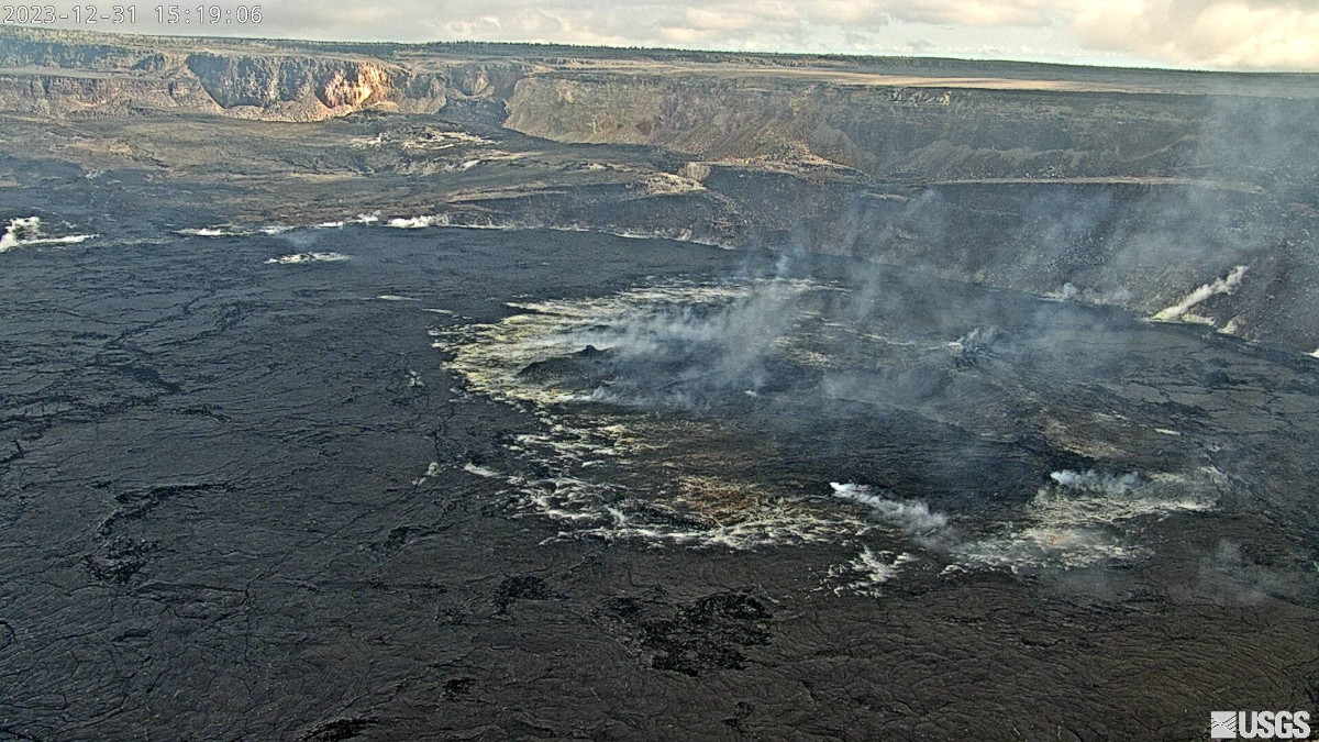
Summit Observations:
The December 29–30 seismic swarm and associated inflation in the southern part of Kīlauea’s summit region has ended, with moderate rates of seismicity being recorded over the past two days. In the past 24 hours about 17 small-magnitude earthquakes (less than M1.5) were recorded south of the caldera, occurring at depths of 1–3 km (0.5–2 mi). Periods of increased or decreased numbers of shallow earthquakes can be expected to continue during repressurization of the summit magma reservoir, which has been ongoing since the end of the September eruption. Seismicity has not reached the levels that immediately preceded recent summit eruptions at Kīlauea.
For the past two days the Sand Hill tiltmeter, located just south of the caldera, has recorded only slight inflation. The summit tiltmeter at Uēkahuna began recording inflationary tilt yesterday morning, as part of another DI event. Kīlauea’s summit region remains at a high level of inflation; relative tilt is above the level reached prior to the most recent eruption in September 2023, and it is higher than at any time since the 2018 eruption.
Sulfur dioxide (SO2) gas emission rates remain low. Field measurements indicated an SO2 emission rate of approximately 80 tonnes per day on December 28, which was similar to measurements in October, November, and early December.
The strong swarm of earthquakes and rapid inflation that occurred south of the caldera on December 29 and 30 indicated that magma was being emplaced at relatively shallow levels. This particular event led to an intrusion, but it is possible that similar events might lead to an eruption in the future. There are currently no signs of an imminent eruption at Kīlauea, but the volcano’s summit region remains unsettled, with a high level of inflation and continued seismic activity. The onsets of previous summit eruptions have been marked by strong swarms of earthquakes caused by magma moving towards the surface 1–2 hours before the appearance of lava. This type of earthquake activity is not being detected at this time.
Source : HVO
Iceland , Reykjanes Peninsula :
Inflation at Svartsengi is slowing down
Indication that magma pressure is building, increasing the likelihood of new dike intrusion and possibly an eruption
Updated 2 January at 14:00 UTC
The rate of ground displacement at Svartsengi is decreasing. Experts gathered at the Meteorological Office this morning confirmed this through an analysis of GPS data.
The deceleration of inflation is an indication that magma pressure is rising, increasing the chances of new dike intrusion and also volcanic eruption. This is a similar change in ground displacement that was observed at the end of the day on December 15, which culminated in an eruption three days later. However, it is difficult to assert whether this pattern will repeat.
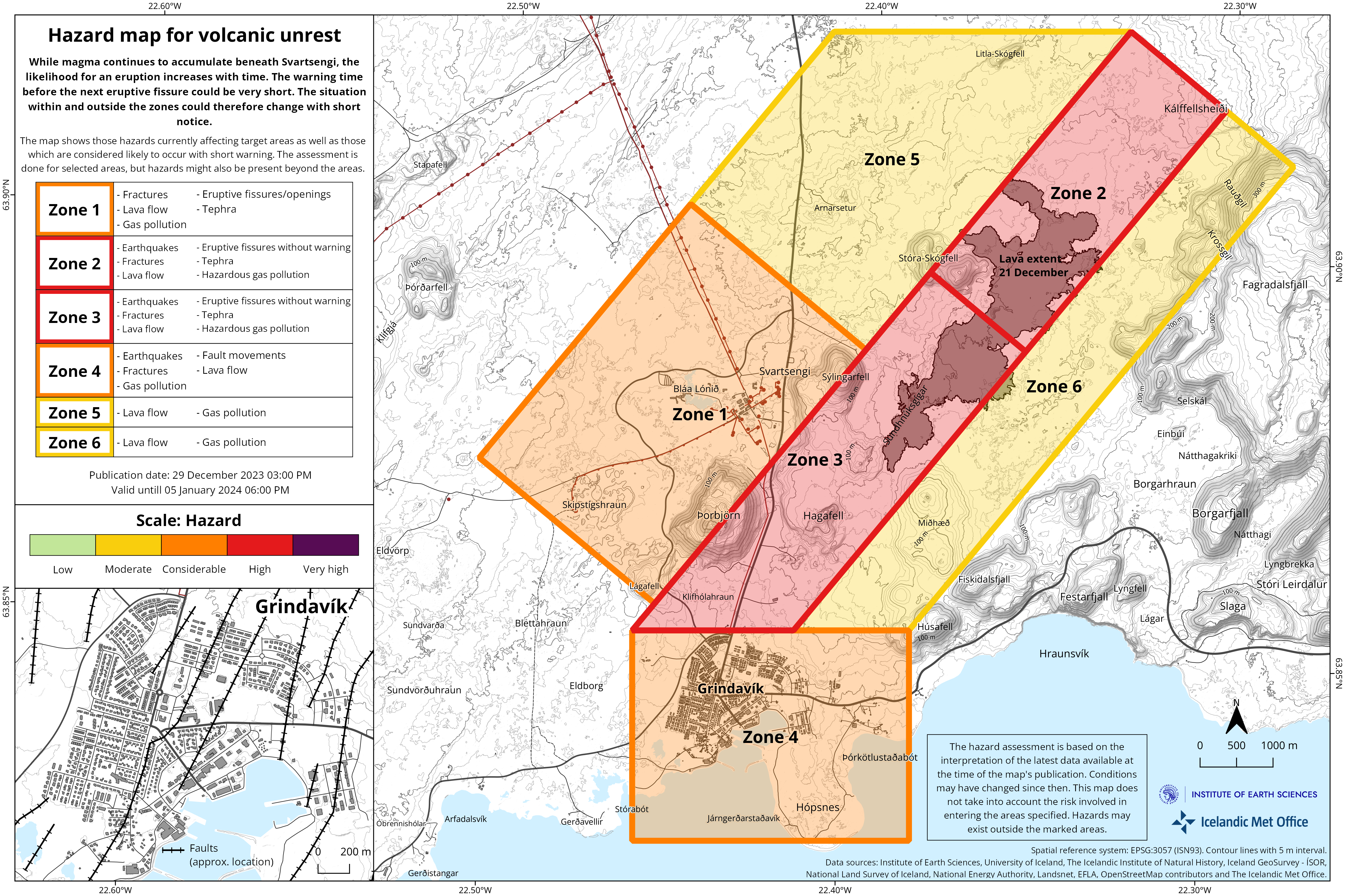
The first signs of an impending volcanic eruption are a sudden increase in seismic activity, and such signs were observed shortly before the eruption began on December 18.
In recent days, seismic activity in the area has been relatively consistant, with around 200 earthquakes recorded per day. Most of the earthquakes measure below magnitude 1.0, but around 30 earthquakes with magnitudes exceeding 1.0 have been recorded since December 29, with the largest being a magnitude 2.1 located in the northern part of Grindavík.
Continued scientific assessment indicates that, should an eruption occur, the Sundhnúkur crater row, between Stóra-Skógafell and Hagafell, is the most probable location for an eruption. However, it is important to note that magma migration does not always result in an eruption, as demonstrated by the activity at Fagradalsfjall and in the Krafla Fires.
Source et photo : IMO.
Philippines , Bulusan :
BULUSAN VOLCANO ADVISORY , 02 January 2024 . 08:00 PM
This is a notice of increased seismic activity at Bulusan Volcano.
A total of one-hundred sixteen (116) volcanic earthquakes has been recorded by Bulusan Volcano Network (BVN) since 9:00 PM of 29 December 2023. Of these, one-hundred ten (110) were volcano-tectonic (VT) earthquakes associated with rock fracturing beneath the southern flanks at depths of two (2) to six (6) kilometers and six (6) were low frequency volcanic earthquakes (LFVQ) associated with movement of volcanic fluids. Ground deformation data from continuous GPS and electronic tilt monitoring respectively recorded inflation or swelling of the southwestern and southeastern slopes since February 2023. In contrast, degassing activity from the summit crater and active vents has been very weak to moderate when the volcano summit has been visible. Nonetheless, increased seismic activity and pressurization of the volcano edifice may indicate that hydrothermal processes may be occurring beneath the volcano and may lead to steam-driven eruptions at any of the summit vents.
The public is reminded that Alert Level 1 prevails over Bulusan Volcano, which means it is currently at low-level unrest with increased chances of steam-driven or phreatic eruptions. Local government units and the public are reminded that entry into the 4-kilometer radius Permanent Danger Zone (PDZ) should be prohibited and that vigilance in the 2-kilometer Extended Danger Zone (EDZ) on the southeast sector must be exercised due to the possibilities of sudden and hazardous phreatic eruptions. Civil aviation authorities must also advise pilots to avoid flying close to the volcano’s summit as ash from any sudden phreatic eruption can be hazardous to aircraft. Furthermore, people living within valleys and along river/stream channels should be vigilant against sediment-laden stream flows and lahars in the event of heavy and prolonged rainfall occurring simultaneous with phreatic eruption.
DOST-PHIVOLCS is closely monitoring Bulusan Volcano’s condition and any new development will be relayed to all concerned.
Source et photo : Phivolcs
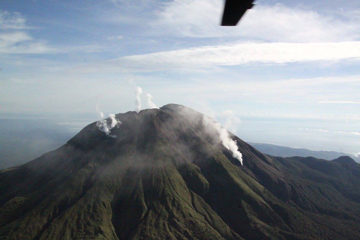
Indonesia , Iya :
Press release on the activity of G. IYA, LEVEL I (NORMAL).
Iya Volcano is administratively located in Ende Regency, East Nusa Tenggara Province and geographically, its summit is located at 8,897° South latitude, 121,645° East longitude and has a height of 637 m au- above sea level. It is a stratovolcano whose eruption history was recorded from 1671 until the last eruption in 1971, with an eruption interval of between 1 and 60 years. The G. Iya is monitored visually and instrumentally from the G. Iya observation post on Jl Ikan Paus, Tewejangga, .
The characteristics of G. Iya eruptions generally take place in the main crater through magmatic eruptions that produce volcanic ash, incandescent rock ejections, and lava flows accompanied by collapses at the summit of Mount Iya. Cracks are developing around the active crater of Mount Iya, indicating a weak area inside the volcano that could lead to a large landslide toward the sea during a future eruption of Mount Iya.
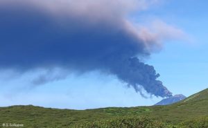
The south side of the small Iya volcano in central Flores with a faint plume rising from a crater near the summit. Gunung Iya is the southernmost of three volcanoes forming a small peninsula south of Ende.
The latest developments on G. Iya’s activities until January 1, 2024 at 6:00 p.m. WITA are as follows:
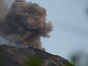
Visual monitoring from G. Iya, indicates that on Sunday, December 31, 2023, the volcano was clearly visible until it was covered in fog, we observed white smoke coming from the main crater with high intensity at around 50 – 80 m from the summit.
From December 1, 2023 to December 31, 2023, 55 deep volcanic earthquakes, 58 local tectonic earthquakes and 54 distant tectonic earthquakes were recorded.
Seismic data from G. Iya shows a significant increase in deep volcanic earthquakes on December 30-31, 2023. 12 VA-type earthquakes were recorded with an amplitude of 4 to 33 mm. This increase in seismicity could indicate an increase in pressure within the body of G. Iya due to increased magmatic activity, but so far no surface earthquakes have been recorded.
Based on the results of observations and analysis of visual and instrumental data, G. Iya’s activity level is still at level I (Normal).
Source : PVMBG.
Photo : Ruska Hadian, 1985 (Volcanological Survey of Indonesia).
Alaska , Shishaldin :
AVO/USGS Volcanic Activity Notice
Current Volcano Alert Level: ADVISORY
Previous Volcano Alert Level: WATCH
Current Aviation Color Code: YELLOW
Previous Aviation Color Code: ORANGE
Issued: Tuesday, January 2, 2024, 11:33 AM AKST
Source: Alaska Volcano Observatory
Notice Number: 2024/A5
Location: N 54 deg 45 min W 163 deg 58 min
Elevation: 9373 ft (2857 m)
Area: Aleutians
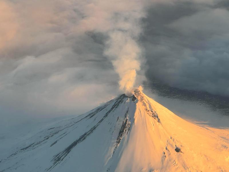
Volcanic Activity Summary:
Volcanic activity at Shishaldin Volcano has gradually declined over the past two months since the last significant explosive event on November 3, 2023. Small explosions within the summit crater continue to be detected in infrasound data during periods of quiet (low wind) conditions but new deposits have not recently been seen inside or outside the crater. Satellite-observed surface temperatures remain low, suggesting lava is not present in the crater. The current activity is consistent with continued volcanic unrest but not an active eruption. Thus, the Aviation Color Code and the Volcano Alert Level are being decreased to YELLOW/ADVISORY.
Shishaldin Volcano is monitored by local seismic and infrasound sensors, web cameras, and a telemetered geodetic network. In addition to the local monitoring network, AVO uses nearby geophysical networks, regional infrasound and lighting data, and satellite images to detect eruptions.
Recent Observations:
[Volcanic cloud height] none observed
[Other volcanic cloud information] intermittent steaming continues
Remarks:
Shishaldin Volcano, located near the center of Unimak Island in the eastern Aleutian Islands, is a spectacular symmetric cone with a base diameter of approximately 10 miles (16 km). A 660 ft. (200 m) wide funnel-shaped summit crater typically emits a steam plume and occasional small amounts of ash. Shishaldin is one of the most active volcanoes in the Aleutian volcanic arc, with at least 54 episodes of unrest including over 26 confirmed eruptions since 1824. Most eruptions are relatively small, although the April-May 1999 event generated an ash column that reached 45,000 ft. (14 km) above sea level.
Source : AVO
Photo : Reedy, Brian