March 22 , 2025.
Hawaii , Kilauea :
Friday, March 21, 2025, 10:12 AM HST (Friday, March 21, 2025, 20:12 UTC)
19°25’16 » N 155°17’13 » W,
Summit Elevation 4091 ft (1247 m)
Current Volcano Alert Level: WATCH
Current Aviation Color Code: ORANGE
Activity Summary:
Kīlauea summit eruption paused as of March 20. Based on less than 24 hours of data since the pause in eruption, preliminary estimates of a new eruptive episode may begin within the next 2-4 days in Hawai’i Volcanoes National Park. Estimates will be refined in the coming days as more data becomes available.
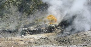
Episode 14 of the ongoing Halemaʻumaʻu eruption ended abruptly at 1:49 p.m. HST on March 20. Episode 14 lasted 28 hours and 23 minutes with the last 7 hours and 19 minutes consisting of fountains up to 600 feet (180 meters) high predominantly from the south vent. Kīlauea’s current eruption in Halemaʻumaʻu crater within Kaluapele (the summit caldera) began on December 23, 2024. There have been 14 episodes of lava fountaining separated by pauses in activity. All eruptive activity remains within Hawai’i Volcanoes National Park. No significant activity has been noted along Kīlauea’s East Rift Zone or Southwest Rift Zone.

As episode 14 lava fountaining occurred during the ongoing Kīlauea summit eruption, the KWcam webcam, F1cam thermal camera and continuous laser rangefinder perched on the crater edge (upper right portion of the photo), provided a continuous record of activity. These cameras were hit by grapefruit-sized pieces of tephra during an earlier episode of fountaining, but were protected by their enclosures.
Current hazards include volcanic gas emissions and windblown volcanic glass (Pele’s Hair) that may impact Hawai’i Volcanoes National Park and nearby communities.
Summit Observations:
Lava flows and fountains stopped erupting from the south vent within Halemaʻumaʻu crater at about 1:49 p.m. HST on March 20. Fountains from the north vent ceased ~ 11 minutes earlier. Lava flows from episode 14 covered 75% of the Halemaʻumaʻu crater floor. Spots of orange glow can still be seen on the crater floor at night as the erupted lava continues to cool. The vents continue to degas and glow at night, indicating magma remains at shallow levels in the vent.
Deflationary tilt at the summit recorded about 6 microradians lost during this episode. Initial deflation was very rapid but slowed at 7:46 a.m. HST when north vent fountains dropped back into the cone and became intermittent. The end of the eruption was coincident with a rapid change from deflation to inflation at the summit and a decrease in seismic tremor intensity. Summit tilt changed rapidly from deflation to inflation, and seismic tremor decreased, at about the same time that the lava fountains stopped erupting on March 20. In the past 19 hours, the Uēkahuna (UWD) tiltmeter has recorded approximately 1 microradians of inflationary tilt since the end of episode 14. Seismic tremor decreased significantly at the end of episode 14 but remains above background. 1 small earthquake was recorded in the summit region over the past 24 hours.

Just after 7:45 a.m. on March 20, the north fountain at the summit of Kīlauea abruptly shut off during episode 14, and the south fountain rose in height. The height was well above the crater rim, roughly 200 meters (650 feet) above the vent.
Volcanic gas emissions remain elevated. A maximum SO2 emission rate measured in the morning on March 20 reached approximately 50,000 t/d. Based on measurements made during earlier episodes and pauses, sulfur dioxide (SO2) emission rates are likely to be approximately 1,000 t/d during the current pause. An SO2 emission rate of 1,500 t/d was measured on March 20 at 5:00 p.m. HST.
Rift Zone Observations:
Rates of seismicity and ground deformation remain very low in the East Rift Zone and Southwest Rift Zone with no significant earthquake activity in the past 24 hours. Sulfur dioxide (SO2) emissions from the East Rift Zone remain below detection limit.
Source : HVO
Photos : USGS / M. Patrick ( 20/03/2025 ).
Indonesia , Lewotobi Laki-laki :
An eruption of Mount Lewotobi Laki-laki occurred on Friday, March 21, 2025, at 01:22 WITA with an observed ash column height of ± 700 m above the peak (± 2284 m above sea level). The ash column was observed to be gray in color with a thick intensity, oriented toward the north and northeast. This eruption was recorded on a seismograph with a maximum amplitude of 11 mm and a duration of 50 seconds.
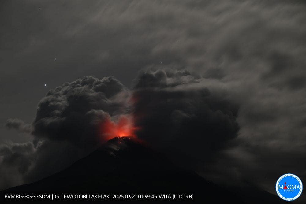
Visual observations on March 20 and 21, 2025, showed that volcanic activity at Mount Lewotobi Laki-laki had increased significantly.
An eruption occurred, accompanied by an explosion that was heard as far away as Maumere and Larantuka, on March 20, 2025, at 22:56 WITA. This eruption was recorded at several volcanic stations on Flores.
The visible incandescence at the summit after the eruption indicated that the incandescent material was located at shallow depths.
A shallow volcanic earthquake (VB) was recorded on March 20, 2025, with the last recorded on February 12, 2025. This indicates that the intensity of magmatic activity in the magma chamber of Lewotobi Laki-laki volcano is increasing and moving toward shallower depths. The number of deep volcanic earthquakes (DVA) increased significantly on March 19-20, 2025, reaching 205 events in one day compared to the previous average of 3-6 events, indicating that the intensity of magmatic activity in the magma pocket of Lewotobi Laki-laki volcano is increasing very rapidly. The significant increase in DVA triggered an explosive eruption at Lewotobi Laki-laki.
Sources : PVMBG , Magma Indonésie.
Photo : Magma Indonésie .
Colombia , Nevado del Ruiz :
Manizales, March 18, 2025, 4:30 p.m.
Monitoring the activity of the Nevado del Ruiz volcano, the Colombian Geological Survey (SGC), an entity affiliated with the Ministry of Mines and Energy, reports that:
During the week of March 11-17, 2025, the volcano continued to exhibit unstable behavior. Compared to the previous week, the main variations in the monitored parameters were:
– Seismic activity associated with rock fracturing processes within the volcanic structure increased in the number of recorded earthquakes and in the seismic energy released. The seismicity was located mainly on the northeast, southeast, south, and west flanks of the volcano, at distances less than 5 km from the Arenas crater and within the crater itself. The depth of the earthquakes ranged from less than 1 km to 9 km from the volcano’s summit. The highest magnitude of the week was 1.5, corresponding to the earthquake recorded on March 17 at 8:30 a.m., located 5 km northeast of the crater, at a depth of 6 km from the volcano’s summit.
– Seismic signals related to fluid dynamics in volcanic conduits generally decreased in the number of recorded earthquakes and in the seismic energy released. These seismic signals presented low and sometimes moderate energy levels, some of them associated with continuous and pulsed ash emissions, which were confirmed by the cameras (conventional or thermographic) used to monitor the volcano. Changes in the apparent temperature of the emitted material were also observed in connection with these ash emissions. As mentioned in last week’s bulletin, on March 11 at 1:00 a.m., a pulsating emission of gas and ash was recorded, associated with the largest temperature change of the week and one of the three highest estimated so far this year.
– The emission of water vapor and gases, mainly sulfur dioxide (SO₂), into the atmosphere through the Arenas crater was variable. Estimated daily SO₂ outgassing values showed levels similar to those of the previous week. It is important to note that atmospheric conditions, with heavy cloud cover and wind direction, continue to be unfavorable for data collection. Satellite monitoring, which is being carried out to complement the assessment of this parameter, continues to show significant SO₂ releases.
– The vertical height of the gas column remained mainly below 600 m measured above the volcano’s summit, with a maximum of 1800 m. In dispersion, the column reached a maximum value of 2100 m during the emission of gas and ash on March 11 at 1:00 a.m. The dispersion direction showed a predominant trend towards the northwest and southwest of the volcano. Due to this preferential wind direction, ashfall occurred in the municipalities of Manizales and Villamaría (Caldas department) on the morning of March 11.
– By monitoring thermal anomalies at the floor of Arenas Crater and using satellite monitoring platforms, some reports of anomalies with low to moderate energy levels were obtained.
Source et photo : SGC
Costa Rica , Poas :
OVSICORI-UNA Statement on Poás Volcano, updated March 21, 2025.
OVSICORI-UNA observes:
● Instability of seismic parameters (swarms, banded tremors),
● Increased tremor amplitude,
● Vertical deformation of crustal uplift.
● Gas compositions and fluxes related to surface magma.
● Decrease in the lake level and water table of the hydrothermal system.
● Hydrothermal system ineffective at capturing volatiles and heat from magma.
● Increased SO2 concentrations in the ambient air of Coronado San José.
We observed that the increase in seismic activity reported on Wednesday, March 19, resulted in moderate phreatic eruptions, smaller than those of March 9. Although eruptions have occurred, no major events have occurred. However, a higher probability scenario for eruptions remains, which could impact visitor areas in Poás Volcano National Park (bomb or rock fall, ash, and gas), as well as communities around Poás (ash, gas) in the coming days and weeks.
The volcano’s activity level is at WARNING level 3 out of 4.
Eruptive Activity:
On the evening of March 14, a sequence of phreatic eruptions was observed at Boca C. On March 19, two eruptions were observed in the afternoon. The largest reached 100 m in height.
Seismic and Acoustic Activity
Since the afternoon of March 18, an increase in the number of high-frequency earthquakes has been observed, reaching a peak of 80 events per hour and a total of 240 in one day. These events occur in the crater area at very shallow depths. Following this seismic swarm, the eruptions of March 19 occurred. A sequence of banded tremors was then observed in the early morning hours of March 20. The amplitude of the tremor has been variable in recent days, with a general upward trend. In the long term, the amplitude of the tremor is high compared to previous eruptive periods (2023-2024 and 2018-2019). Distal volcano-tectonic seismicity remains constant, with an event occurring on average every day.
Hyperacid Lake Level
A temporary rise in the lake level was observed due to the eruptions of March 9, which connected the two residual lakes. In addition, the rain of March 16 raised the lake level. However, despite these two epiphenomena, the levels of both lakes are decreasing rapidly (3 m in 3 weeks, 1.2 m in 1 week). Based on current trends, rough projections suggest that complete drying of the residual lakes is likely by early or mid-April.
Source et photo : Ovsicori.
La Martinique , Mount Pelée :
Weekly Report, Paris Institute of Earth Physics / Martinique Volcanological and Seismological Observatory
Saint-Pierre, March 21, 2025, at 6:00 p.m. local time (GMT-4)
Volcanic activity was significant this week, with 221 earthquakes of volcanic origin observed.
Between March 14, 2025, at 4:00 p.m. (UT) and March 21, 2025, at 4:00 p.m. (UT), the OVSM recorded 221 low-energy volcano-tectonic earthquakes. These earthquakes mainly occurred between March 15, at 7:00 p.m. (UT) and March 19, at 11:00 a.m. (UT), in the form of successive swarms lasting a few hours each. These earthquakes were clearly identified as originating from one of the well-known seismically active zones on Mount Pelée, located between 1.0 and 1.4 km deep beneath the volcano’s summit. The shallow volcano-tectonic seismicity is associated with microfracturing within the volcanic edifice, linked to the overall reactivation of the volcano observed since late 2018.
None of these earthquakes were felt by the population.

The previous week, the OVSM had recorded 18 volcanic earthquakes. As of March 21, 2025, and over the past four weeks, the OVSM has observed a total of 278 volcanic earthquakes, an average of 69 to 70 earthquakes per week.
During phases of volcanic reactivation in volcanoes similar to Mount Pelée, seismic activity of varying intensity and frequency is commonly observed.
For more details on observations and interpretations of volcanic activity over the longer term, refer to the OVSM’s monthly bulletins.
The alert level is currently YELLOW: vigilance.
Magnitude 3.1, 14.75°N, 61.00°W, depth 5 km, Saturday, March 22, 2025, 04:08 UT
An earthquake (magnitude 3.1) was recorded on Saturday, March 22, 2025, at 00:08 (local time) and identified as tectonic in origin. The epicenter was located 3 km south-southwest of Sainte-Marie, at a depth of 5 km (a hypocentral distance of approximately 6 km). This earthquake may have generated, in the nearest affected areas, an average ground acceleration of 9.5 mg, corresponding to a macroseismic intensity IV (widely felt). Depending on the soil type, however, intensities may have locally reached intensity V-VI (potential slight damage).
Source : Direction de l’OVSM-IPGP.
Photo : IPGP