March 06 , 2025 .
Hawaii , Kilauea :
Wednesday, March 5, 2025, 11:48 AM HST (Wednesday, March 5, 2025, 21:48 UTC)
19°25’16 » N 155°17’13 » W,
Summit Elevation 4091 ft (1247 m)
Current Volcano Alert Level: WATCH
Current Aviation Color Code: ORANGE
Activity Summary:
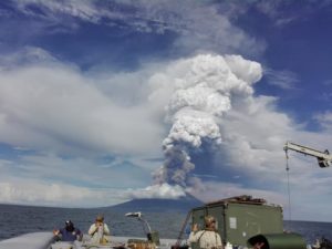
Episode 12 of the Halemaʻumaʻu eruption of Kīlauea within Hawaiʻi Volcanoes National Park ended at 10:37 a.m. HST on March 5 after just under 22 hours of continuous eruptive activity. Fountaining from the south vent ceased at 10:35 a.m. at the same time summit deflation changed to inflation and tremor decreased. Current hazards include volcanic gas emissions and windblown volcanic glass (Pele’s Hair) that may impact Hawai’i Volcanoes National Park and nearby communities.
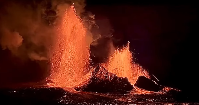
Episode 12 began yesterday, March 4, when small, intermittent flows first erupted at 7:30 a.m. and 9:33 a.m., followed by continuous eruption of sluggish flows at 12:45 p.m. Lava fountaining began at 2:00 p.m. Fountains reached heights of 600 feet (180 meters) by 3:00 p.m. These heights were sustained until the north vent quit erupting at 8:26 p.m. Sustained fountains from the south vent continued overnight with heights of 200-400 feet (60-120 meters) before decreasing this morning, March 5, after 5:00 a.m. Fountaining from the south vent increased again around 8:00 a.m., and the north vent briefly resumed fountaining and erupting lava flows from 8:42 to 9:11 a.m., before both vents quit erupting after 10:30 a.m. Lava flows from this episode covered over two thirds of the floor of Halemaʻumaʻu within the southern part of Kaluapele (Kīlauea caldera).
SO2 emission rates were averaging approximately 35,000 tonnes per day (t/d) during the period of high fountaining yesterday afternoon, March 4, but were down to around 20,000 t/d this morning during lower fountaining. SO2 emission rates during the pause period are estimated to be about 1,000 tones per day, similar to those measured during other pauses in this ongoing eruption.
Summit tiltmeters recorded about 11 microradians of deflation during episode 12. The end of fountaining at 10:35 a.m. was coincident with a rapid change from summit deflation to inflation and a decrease in seismic tremor intensity.
This was the 12th episode of Kīlauea’s ongoing eruption in Halemaʻumaʻu crater within Kaluapele that began on December 23, 2024. Eruptive episides have lasted from 12 hours to 8 days. Episodes have been separated by pauses in eruptive activity lasting less than 24 hours to 12 days.
Source : HVO
Photo : Capture d’écran Private Volcano Tours via Linda McIlroy / FB.
Italy / Sicily , Etna :
Etna Activity Statement, 05 March 2025, 12:13 (11:13 UTC) .
The National Institute of Geophysics and Volcanology, Osservatorio Etneo, announces the end of the previously reported phenomena. In particular, from the inspections carried out by INGV staff in the field and from the analysis of images from the video surveillance network, it has been observed that from 2 March onwards, the emission of lava from the eruptive vent opened on 8 February has gradually ceased and the lava field appears to be cooling down.
From a seismic point of view, it should be noted that the average amplitude of the volcanic tremor is at a medium level with an almost stationary trend and the centroid of its sources is located in the area of the Bocca Nuova crater at an altitude of about 2,800 m above sea level. Infrasound activity is currently absent.
From a deformation point of view, there are no significant variations. The stress/tilt signals have returned to their usual range of variation since the beginning of March.
Further updates will be communicated shortly.
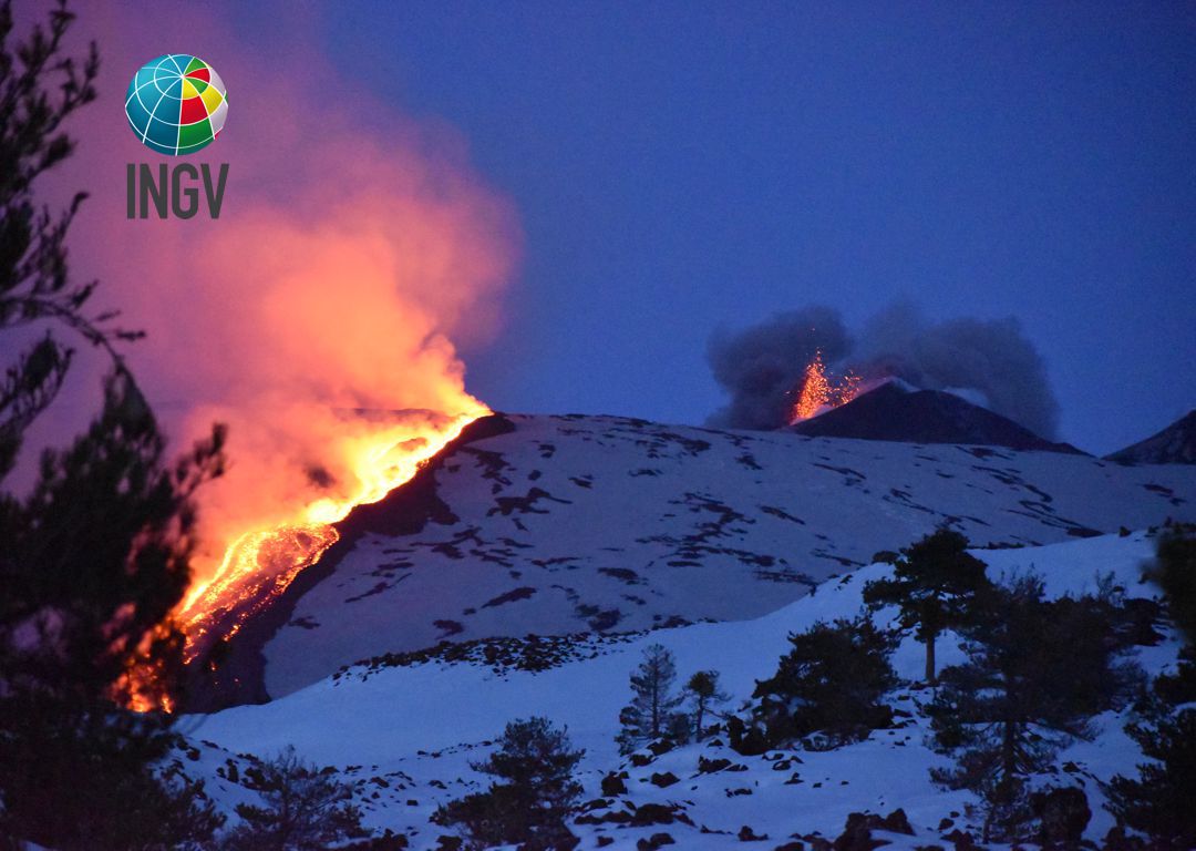
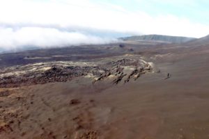
The Sezione di Catania – Osservatorio Etneo (INGV) reported that an eruption at Etna continued during 24 February-2 March. Activity observed through webcams and during field inspections on 28 February and 2 March was characterized by the effusion of lava flows from at least four vents, Strombolian activity at the summit, and gas emissions at several of the summit craters. Strombolian activity at SE Crater stopped on 25 February and the effusion rate at the fissure on the upper S flank of Bocca Nuova Crater decreased significantly. On 27 February Strombolian activity resumed at SE Crater and lava effusion increased at Bocca Nuova Crater. Lava overflowed the SE Crater on 28 February. That same day several new features on the upper S flank of Bocca Nuova Crater were identified in drone images. Several small cracks partly surrounding a 150-m-long, oval depression, oriented NE-SW, was located just upflank of the eruptive fissure. At a higher elevation than the depression was a vent that produced a yellow fumarolic plume. Thermally anomalous areas were located about 100 m both to the E and W of the depression. The lava-flow fronts were most active at an elevation of 2,750 m. Strombolian activity at SE Crater ceased during the evening of 28 February. Lava effusion at the Bocca Nuova vent continued during 1-2 March at a low rate.
Sources : INGV , GVP.
Photo : INGV / Marco Neri
Japan , Yakedake :
The Japan Meteorological Agency (JMA) raised the Alert Level for Yakedake to 2 (on a scale of 1-5) at 0920 on 4 March, noting that the number of small volcanic earthquakes with epicenters near the summit began increasing around 1400 the day before. Additionally, inflation near the summit was detected in Global Navigation Satellite Systems (GNSS) data. JMA warned the public to be cautious within 1 km of the cater.
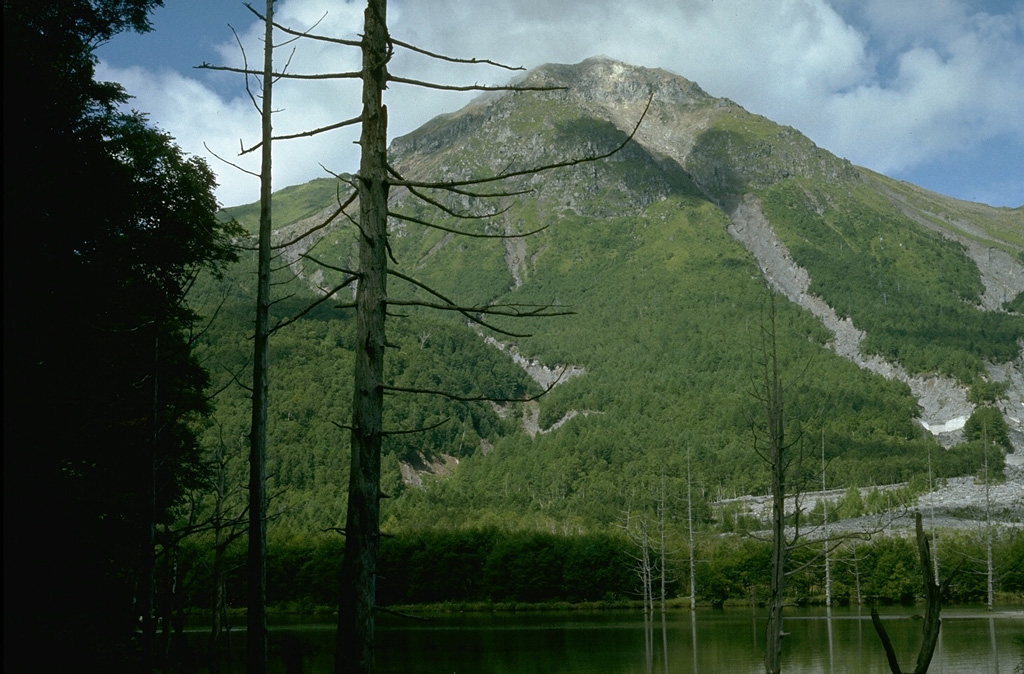
Yakedake rises above Kamikochi resort in the Northern Japan Alps, seen here from Taishoike pond to its ENE. It contains a 300-m-wide crater at the summit and craters are found on the SE and N flanks. Frequent small-to-moderate phreatic eruptions have occurred during the 20th century from both summit and flank vents. An eruption in 1915 produced a lahar that created Taishoike pond and killed the trees in the foreground.
Yakedake rises above the popular resort of Kamikochi in the Northern Japan Alps. The small dominantly andesitic stratovolcano, one of several Japanese volcanoes named Yakedake or Yakeyama (« Burning Peak » or « Burning Mountain »), was constructed astride a N-S-trending ridge between the older volcanoes of Warudaniyama and Shirataniyama. Akandanayama, about 4 km SSW, is a stratovolcano with lava domes that was active into the Holocene. A 300-m-wide crater is located at the summit, and explosion craters are found on the SE and N flanks. Frequent small-to-moderate phreatic eruptions have occurred during the 20th century. On 11 February 1995 a hydrothermal explosion in a geothermal area killed two people at a highway construction site.
Sources: Japan Meteorological Agency (JMA) , GVP.
Photo : Lee Siebert, 1977 (Smithsonian Institution)
Costa Rica , Turrialba / Poas :
Turrialba Volcano :
On 3 March the Observatorio Vulcanológico y Sismológico de Costa Rica-Universidad Nacional (OVSICORI-UNA) reported that over the previous few days small collapses occurred from the inner SW wall of Turrialba’s West Crater, in the same area that is sometimes incandescent. Material from the collapses was mostly deposited inside the crater, though some ash rose above the rim. At 0933 a small ash eruption that lasted for 15 seconds produced an ash-and-gas plume that rose 100 m and drifted SW. No collapses were recorded on 4 March.
Poas Volcano :
The Observatorio Vulcanológico y Sismológico de Costa Rica-Universidad Nacional (OVSICORI-UNA) reported that eruptive activity at Poás continued at variable levels during 21 February-4 March.
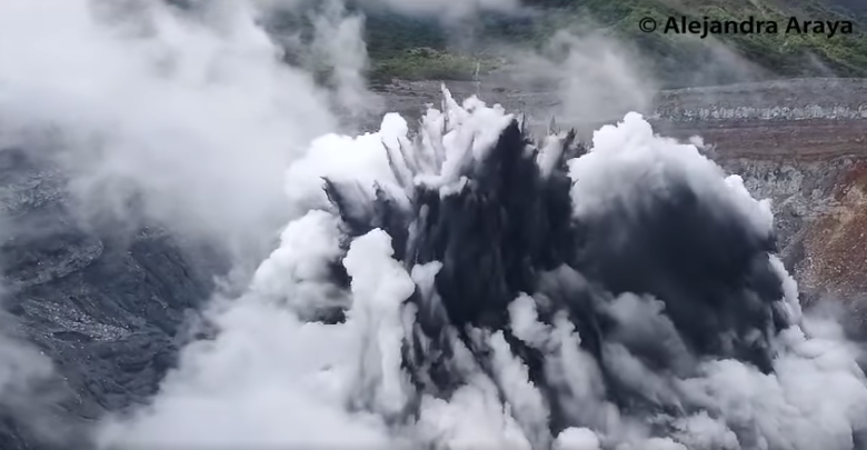
Sulfur dioxide levels fluctuated at high levels. There were no eruptive events recorded during 21-22 February. Frequent small phreatic eruptions from Boca C were detected on 23 February at a rate of 5-20 per hour. Frequent small phreatic eruptions from both Boca A and Boca C continued during 25 February-4 March; the events produced plumes of steam and gas and ejected material to heights as high as 100 m above the surface of Laguna Caliente. According to a news article ashfall may have been reported as far as Sarchí (17 km SW) during 1-2 March, and a strong sulfur odor was reported in several areas near the volcano.
Sources : Observatorio Vulcanologico y Sismologico de Costa Rica-Universidad Nacional (OVSICORI-UNA), Tico Times , GVP.
Photo : Alejandra Alaya , Capture d’écran Poas 06 Mars 2025 .
Vanuatu , Yasur :
On 27 February the Vanuatu Meteorology and Geohazards Department (VMGD) reported that activity at Yasur continued at a level of “major unrest,” as defined by the Alert Level 2 status (on a scale of 0-5). Satellite and webcam images indicated that explosions continued, producing emissions of gas, steam, and/or ash. Gas emissions were identified in satellite images, and seismic data confirmed continuing volcanic activity with explosions that were occasionally strong. Low-level thermal anomalies were identified in satellite images during 12-13 and 16 February. The report warned that ejected material from explosions could fall in and around the crater. The public was reminded to not enter the restricted area within 600 m around the boundaries of the Permanent Exclusion Zone, defined by Danger Zone A .
Yasur has exhibited essentially continuous Strombolian and Vulcanian activity at least since Captain Cook observed ash eruptions in 1774. This style of activity may have continued for the past 800 years. Located at the SE tip of Tanna Island in Vanuatu, this pyroclastic cone has a nearly circular, 400-m-wide summit crater. The active cone is largely contained within the small Yenkahe caldera, and is the youngest of a group of Holocene volcanic centers constructed over the down-dropped NE flank of the Pleistocene Tukosmeru volcano. The Yenkahe horst is located within the Siwi ring fracture, a 4-km-wide open feature associated with eruption of the andesitic Siwi pyroclastic sequence. Active tectonism along the Yenkahe horst accompanying eruptions has raised Port Resolution harbor more than 20 m during the past century.
Sources: Vanuatu Meteorology and Geohazards Department (VMGD), GVP
Photo : Michel Massat