March 02 , 2025 .
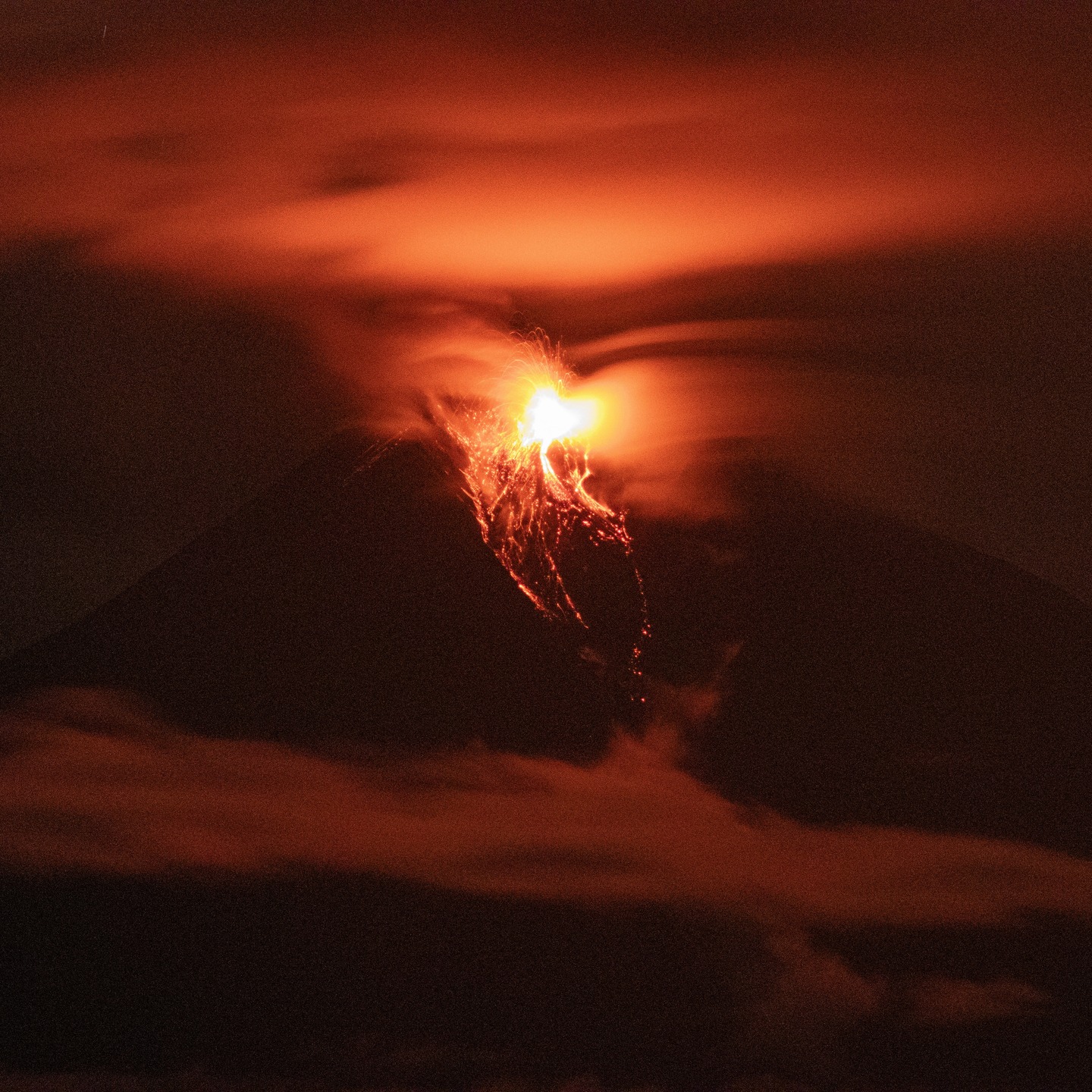
Italy , Stromboli :
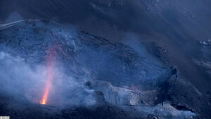
Statement on Stromboli activity, 01 March 2025, 15:16 (14:16 UTC) .
The National Institute of Geophysics and Volcanology, Osservatorio Etneo, reports that surveillance camera images show that the lava overflow fed by the North Crater area, reported in the previous press release, has stopped and is cooling. Ordinary explosive activity at varying rates persists in both crater areas.
After reaching its maximum value around 12:30 UTC yesterday, the average amplitude of volcanic tremor showed a continuous and progressive decrease and around 13:00 UTC today it reached low values. No significant changes were reported in the occurrence rate and amplitude of explosion earthquakes.
High-frequency data from GPS stations show no significant deformation.
Further updates will be communicated shortly.
Source : INGV
Photo : Stromboli stati d’animo / Sebastiano Cannavo
United-States , Yellowstone :
Saturday, March 1, 2025, 8:39 AM MST (Saturday, March 1, 2025, 15:39 UTC)
44°25’48 » N 110°40’12 » W,
Summit Elevation 9203 ft (2805 m)
Current Volcano Alert Level: NORMAL
Current Aviation Color Code: GREEN
Summary
Yellowstone Caldera activity remains at background levels, with 42 located earthquakes in February (largest = M2.6). Deformation measurements indicate a small amount of caldera subsidence since early October.
Recent Work and News
Just before midnight on February 3, Steamboat Geyser had its first major eruption of the year.
Happy 153rd birthday to Yellowstone National Park, which was founded on this day in 1872!
Seismicity
During February 2025, the University of Utah Seismograph Stations, responsible for the operation and analysis of the Yellowstone Seismic Network, located 42 earthquakes in the Yellowstone National Park region. The largest event of the month was a micro earthquake of magnitude 2.6 located about 14 miles southeast of West Thumb in Yellowstone National Park on February 11 at 1:35 AM MST.
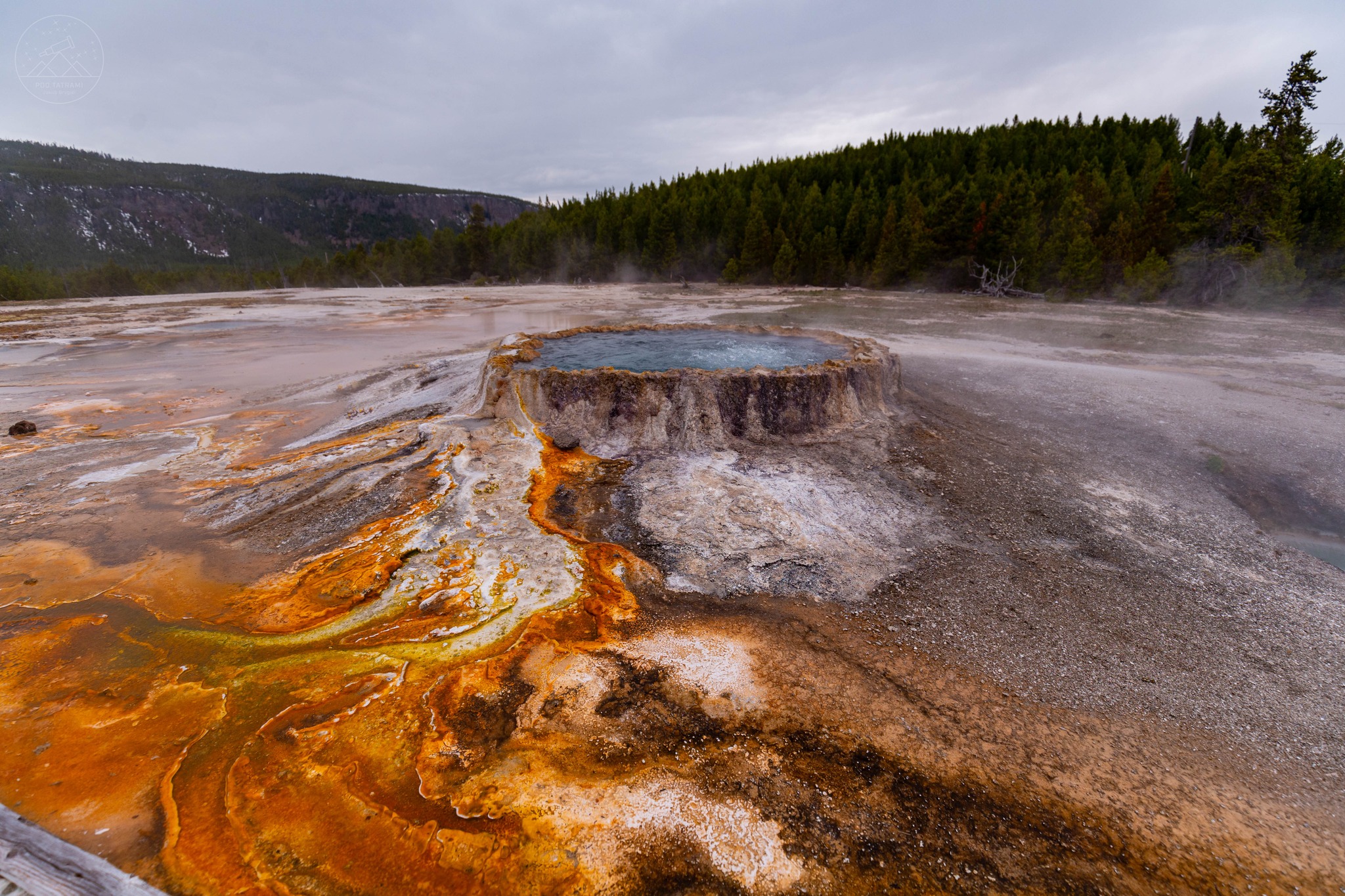
Punch Bowl Spring is another interesting hot spring that can be found in Yellowstone National Park. It definitely attracts the observer’s attention with its unusual appearance – it is surrounded by a rim whose edges resemble a saw blade for cutting wood. The water filling the spring is boiling all the time – even though it has a temperature of about 92 degrees Celsius. This is because the Yellowstone caldera is located at an altitude of about 2,000 meters above sea level and there is much lower pressure there than at sea level.
February seismicity in Yellowstone was marked by two swarms.
A swarm of 18 earthquakes was located approximately 13 miles south-southwest of Mammoth, in Yellowstone National Park, during February 1–8. The largest earthquake in the sequence was a magnitude 1.6 on February 3 at 1:24 AM MST.
A swarm of 11 earthquakes took place approximately 5 miles south-southeast of West Thumb, in Yellowstone National Park, on February 11. The largest earthquake in the sequence was a magnitude 2.4 on February 11 at 1:44 AM MST.
Yellowstone earthquake activity is currently at background levels.
Ground Deformation
Continuous GPS stations in Yellowstone Caldera recorded a small amount (about 2 centimeters, or 0.8 inches) of subsidence since October. This pattern and rate of subsidence continues a trend that started in 2015–2016. Minor subsidence (less than 1 centimeter) was also measured by a continuous GPS station near Norris Geyser Basin since the end of last summer.
Source : YVO
Photo : via Pod Tatrami / FB.
Ecuador , Sangay :
DAILY STATE REPORT OF SANGAY VOLCANO, Saturday, March 01, 2025.
Information Geophysical Institute – EPN.
Surface Activity Level: Moderate, Surface Trend: No change
Internal Activity Level: Moderate, Internal Trend: No change
Seismicity: From February 28, 2025, 11:00 a.m. to March 01, 2025, 11:00 a.m.:
Seismicity:
Below is the count of seismic events recorded at the reference station
Explosion (EXP): 106
Precipitation/Lahars:
The presence of rain in the area of the volcano or in the surrounding area, which could generate mud and debris flows, was not recorded by the surveillance cameras. **In the event of heavy rain, it could remobilize the accumulated materials, generating mud and debris flows that would descend the sides of the volcano and flow into adjacent rivers.
Emission/Ash Column:
Due to weather conditions, it was not possible to observe gas or ash emissions via the surveillance camera network or the GOES-16 satellite system. The Washington VAAC agency has not published any reports of ash clouds from this volcano.
Other monitoring parameters:
The MIROVA-MODIS satellite system recorded 2 thermal anomalies in the last 24 hours.
Observation:
Despite the cloudiness in the region, incandescences have been observed in the crater of the volcano since yesterday evening.
Alert level: yellow
Source : IGEPN
Photo : Cristopher Cárdenas
Colombia , Nevado del Ruiz :
Manizales, February 25, 2025, 5:00 p.m. .
Following the monitoring of the activity of the Nevado del Ruiz volcano, the Colombian Geological Survey (SGC), an entity attached to the Ministry of Mines and Energy, reports that:
During the week of February 18 to 24, 2025, the volcano continued to display unstable behavior. Compared to the previous week, the main variations in the monitored parameters were:
– Seismicity related to fluid dynamics in volcanic conduits associated with continuous ash emission and long-period signals decreased slightly and presented lower energy levels. As for the seismic signals associated with pulsatile ash emission, they increased in the number of earthquakes recorded and decreased in seismic energy released. The occurrence of the seismic event, associated with an ash emission, recorded on February 21 at 10:25 am, is remarkable, which reached a moderate level of seismic energy. Thanks to the cameras (conventional or thermographic) used to monitor the volcano and the reports of the officials of the Los Nevados National Natural Park, some emissions of gas and ash were confirmed. Changes in the apparent temperature of the emitted material were also observed in several of the recorded emissions.

– Seismic activity associated with rock fracturing processes within the volcanic edifice has decreased in the number of recorded earthquakes and in the seismic energy released. Most of the earthquakes were located at distances of up to 13 km from the Arenas crater, on the northeast, west, southwest and southeast flanks of the volcano, at depths between 1 km and 8 km measured from the summit. In addition, low-magnitude earthquakes were recorded in the Arenas crater, at depths less than 2 km from the summit of the volcano. The largest earthquake of the week occurred on February 24 at 16:36 with a value of 1.7 and was located 3 km west-southwest of the Arenas crater, at a depth of 2 km from the summit of the volcano. During the week, seismic activity continued at a low energy level and was related to the activity of the lava dome (protuberance or mound) located at the bottom of the crater.
The emission of water vapor and gases, mainly sulfur dioxide (SO₂), into the atmosphere through the Arenas crater was variable and increased in the estimated SO₂ degassing values compared to previous weeks. This is due to an increase in the measured SO2 concentration and to the fact that the weather conditions and wind direction favored the data collection from the measuring instruments installed on the volcano. Satellite monitoring, carried out in a complementary manner to evaluate this parameter, continues to show significant SO₂ releases into the atmosphere.
– The height of the gas column remained mainly below 800 m measured at the summit of the volcano, with a maximum of 1800 m estimated during the ash emission that occurred on February 20 at 02:28. Regarding the direction of dispersion of the column, it showed a predominant trend towards the West-Northwest of the volcano, with occasional variations towards the Northwest and West-Southwest, generating ash falls on February 21 and 23 in the municipalities of Manizales, Villamaría and Chinchiná (Caldas department). – When monitoring thermal anomalies at the bottom of the Arenas crater, using satellite monitoring platforms, some reports of low-energy anomalies were obtained.
Source et photo : SGC.
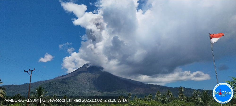
Indonesia , Lewotobi Laki-laki :
An eruption of Mount Lewotobi Laki-laki occurred on Sunday, 2 March 2025 at 12:16 WITA with an observed ash column height of ±1300 m above the peak (±2884 m above sea level). The ash column was observed to be gray with moderate intensity, oriented towards the northwest. This eruption was recorded on a seismograph with a maximum amplitude of 4.4 mm and a duration of 89 seconds.
VOLCANO OBSERVATORY NOTICE FOR AVIATION – VONA
Issued : March 02 , 2025
Volcano : Lewotobi Laki-laki (264180)
Current Aviation Colour Code : ORANGE
Previous Aviation Colour Code : orange
Source : Lewotobi Laki-laki Volcano Observatory
Notice Number : 2025LWK114
Volcano Location : S 08 deg 32 min 20 sec E 122 deg 46 min 06 sec
Area : East Nusa Tenggara, Indonesia
Summit Elevation : 5069 FT (1584 M)
Volcanic Activity Summary :
Eruption with volcanic ash cloud at 04h16 UTC (12h16 local).
Volcanic Cloud Height :
Best estimate of ash-cloud top is around 9229 FT (2884 M) above sea level or 4160 FT (1300 M) above summit. May be higher than what can be observed clearly. Source of height data: ground observer.
Other Volcanic Cloud Information :
Ash cloud moving to northwest. Volcanic ash is observed to be gray. The intensity of volcanic ash is observed to be medium.
Remarks :
Eruption recorded on seismogram with maximum amplitude 4.4 mm and maximum duration 89 second.
Source et photo : Magma Indonésie.