February 6 2025
Hawaii , Kilauea :
Wednesday, February 5, 2025, 11:56 AM HST (Wednesday, February 5, 2025, 21:56 UTC)
19°25’16 » N 155°17’13 » W,
Summit Elevation 4091 ft (1247 m)
Current Volcano Alert Level: WATCH
Current Aviation Color Code: ORANGE
Activity Summary:
The Kīlauea summit eruption paused at 7:23 p.m. HST, on February 4.
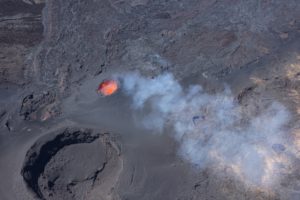
This view from the western caldera rim shows the fountaining at the summit of Kīlauea during the morning of February 4, 2025. Lava fountains were supplying lava into a large ponded area, which had numerous small channels sending lava north and east across the crater floor.
Episode 8 of the ongoing Halemaʻumaʻu eruption ended abruptly at 7:23 p.m. HST on February 4 after about 21.5 hours of eruptive activity. Kīlauea’s current eruption in Halemaʻumaʻu crater within Kaluapele (the summit caldera) began on December 23, 2024. There have been 8 episodes of lava fountaining separated by pauses in activity. Earthquake counts remain low beneath the summit and rift zones. All eruptive activity has occurred in Hawai’i Volcanoes National Park. No unusual activity has been noted along Kīlauea’s East Rift Zone or Southwest Rift Zone.
Current hazards include volcanic gas emissions and windblown volcanic glass (Pele’s Hair) that may impact Hawai’i Volcanoes National Park and nearby communities.
Summit Observations:
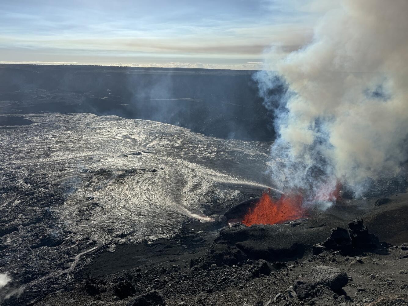
Lava flows and fountains stopped erupting from the north vent within Halemaʻumaʻu crater at about 7:07 p.m. HST on February 4, followed by the south vent at 7:23 p.m. HST. Lava flows from episode 8 covered greater than half of the Halemaʻumaʻu crater floor. Spots of orange glow can still be seen on the crater floor as the erupted lava continues to cool. Glow from the eruptive vents diminished between 1:45 and 3:30 a.m. HST indicating magma is lower in the vent system than during previous pauses.
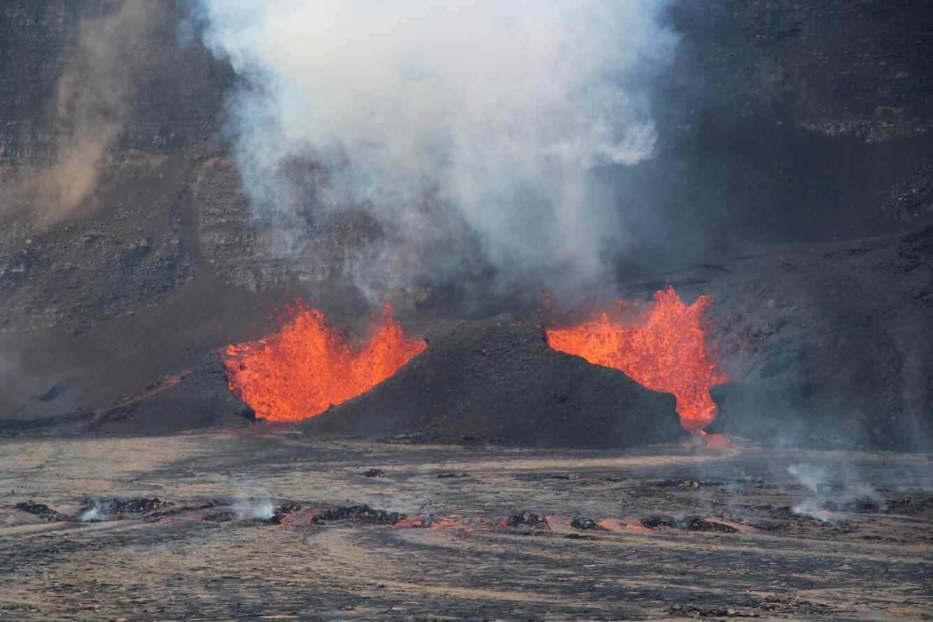
This telephoto view of the active eruptive vents within Halema‘uma‘u crater was captured during the eighth episode of the ongoing Kīlauea summit eruption. Like most of the other recent episodes, this one has had two eruptive vents, known informally as the north vent (right) and south vent (left). Both are actively fountaining and effusing lava flows onto the crater floor.
Summit tilt changed rapidly from deflation to inflation, and seismic tremor decreased, at about the same time that the lava fountains stopped erupting. The Uēkahuna tiltmeter (UWD) recorded about 11 microradians of deflationary tilt during episode 8 and about 1.3 microradians of inflationary tilt since the end of episode 8. Seismic tremor decreased significantly at the end of episode 8, but remains above background. No significant earthquakes were recorded in the summit region over the past 24 hours.
Wind conditions did not allow for an SO2 emission rate measurement during episode 8, but emissions were likely around 10,000 t/d or more, based on measurements made during earlier episodes of this eruption. SO2 emissions have now decreased and are likely to be approximately 1,000 t/d during the current pause.
Rift Zone Observations:
Rates of seismicity and ground deformation remain very low in the East Rift Zone and Southwest Rift Zone with no significant earthquake activity in the past 24 hours. Sulfur dioxide (SO2) emissions from the East Rift Zone remain below detection limit.
Source : HVO
Photo : USGS / M. Patrick , USGS / M. Zoeller .
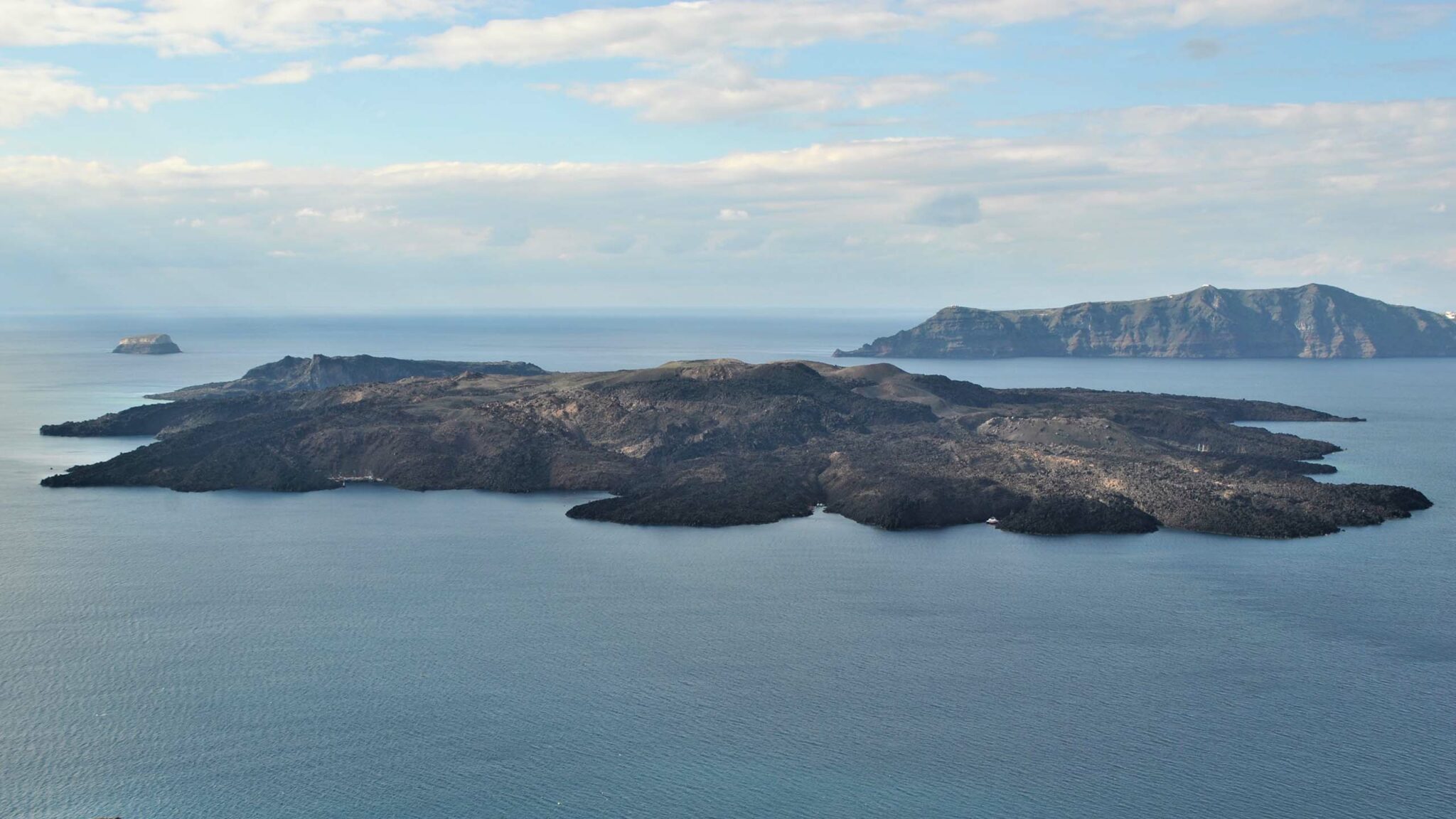
Greece , Santorini / Kolumbo :
According to the Ministry for Climate Crisis and Civil Protection, Greece, press release on 29 January, seismicity increased near Santorini, along the central Kameni fault in the N part of the caldera. Seismicity intensified and shifted NE to an area between the islands of Thira and Amorgos along a NE-SW-trending fault; during 31 January-1 February the largest earthquake was a M 4.3. The submarine Kolumbo volcano is located along that fault line, about 7 km NE of Santorini, though at the time scientists attributed the seismicity to tectonic activity. The Geodynamic Institute of the National Observatory of Athens reported more than 31,000 recorded earthquakes in that area, in a zone extending 15 km long, during 1-4 February, including 630 located events at depths of 2-18 km; events consisted of 155 at M 3.5-3.9, 48 at M 4-4.4, 21 at M 4.5-4.9, and one at M 5. During 4-5 February seismicity extended along an area about 30 km long. The seismicity was similar to a seismic crisis during 2010-2012 that did not lead to a volcanic eruption, though the previous activity was more intense and with larger average earthquake magnitudes.
According to news articles schools on islands including Santorini, Thira, Anafi, Ios, Amorgos, Mykonos, Leros, Syros, and Patmos were closed on 2 February through at least 4 February. Gatherings in enclosed spaces within Municipality of Thira were cancelled. By 3 February more than 11,000 people had left Santorini by ferry or plane, and additional flights to the islands were being scheduled to assist moving people to Athens.
The submarine Kolumbo volcano is about 15 km NE of the center of the Santorini caldera. Although previously considered to be part of a volcanic field associated with Santorini along a fault zone, Klaver et al. (2016) concluded that Kolumbo was a distinct volcanic system with « a deep differentiation history » based on « a signature of high 208Pb/206Pb compared to Santorini ». A strong eruption during September-November 1650 CE killed over 60 people, along with livestock, due to toxic gas emissions; ashfall reached mainland Turkey, and an island of pumice rose above sea level but was rapidly eroded. Klaver et al. (2016) describe the current crater as roughly oval-shaped with a diameter of ~1.7 km, with the crater floor at 500 m below sea level, and the highest point of the crater rim at -18 m. A chain of 19 smaller volcanic features extends ~10 km NE from this primary crater.
Sources: CNN, CBS News, BBC News, Greek City Times, National Observatory of Athens, Ministry for Climate Crisis and Civil Protection , GVP
Photo : Nea Kameni National geological Park
Japan , Sakurajima :
The Japan Meteorological Agency (JMA) reported ongoing eruptive activity at Minamidake Crater (Aira Caldera’s Sakurajima volcano) during 27 January-3 February. Nightly crater incandescence was visible in webcam images. Eruptive events recorded during 17 and 30-31 January produced ash plumes that rose 0.8-1.7 km above the crater rim and drifted E and SE. Ash plumes were continuous during 20h43-20h50 on 30 January. Explosions at 20h13 on 30 January, at 15h48 on 31 January, and at 16h10 on 3 February generated ash plumes that rose 0.8-1.5 km above the crater rim and drifted SE. The explosion at 15h48 on 31 January also ejected large blocks 300-500 m from the crater rim. The Alert Level remained at 3 (on a 5-level scale), and the public was warned to stay 1 km away from both craters.
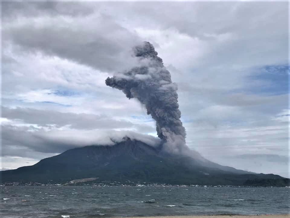
The Aira caldera in the northern half of Kagoshima Bay contains the post-caldera Sakurajima volcano, one of Japan’s most active. Eruption of the voluminous Ito pyroclastic flow accompanied formation of the 17 x 23 km caldera about 22,000 years ago. The smaller Wakamiko caldera was formed during the early Holocene in the NE corner of the caldera, along with several post-caldera cones. The construction of Sakurajima began about 13,000 years ago on the southern rim and built an island that was joined to the Osumi Peninsula during the major explosive and effusive eruption of 1914. Activity at the Kitadake summit cone ended about 4,850 years ago, after which eruptions took place at Minamidake. Frequent eruptions since the 8th century have deposited ash on the city of Kagoshima, located across Kagoshima Bay only 8 km from the summit. The largest recorded eruption took place during 1471-76.
Sources : Agence météorologique japonaise (JMA), GVP.
Photo :Koki Arima
Colombia , Puracé – Chaîne volcanique Los Coconucos :
Popayan, February 4, 2025, 3:30 p.m.
Following the monitoring of the activity of the Puracé volcano – Los Coconucos volcanic chain, the Colombian Geological Survey (SGC), an entity attached to the Ministry of Mines and Energy, reports that:
During the week of January 28 to February 3, 2025, seismic activity showed an increase in the number of events, as reported in the extraordinary bulletin of February 2 at 10:30 a.m. The earthquakes related to rock fracturing occurred at depths between 1 and 3 km below the crater of the Puracé volcano, with a maximum recorded magnitude of 1.7, corresponding to an earthquake that occurred at 5:00 p.m. (local time) on February 1. The fluid events had depths of less than 1 km, located below the crater of the Puracé volcano. Among these, the recording of a continuous tremor signal on January 30 and 31 and February 1 stands out, with a low energy input.
The calculated values of the sulfur dioxide (SO2) flux remain above the reference levels. The slow deformation process continues to be recorded between the volcanic buildings of Puracé, Piocollo and Curiquinga.
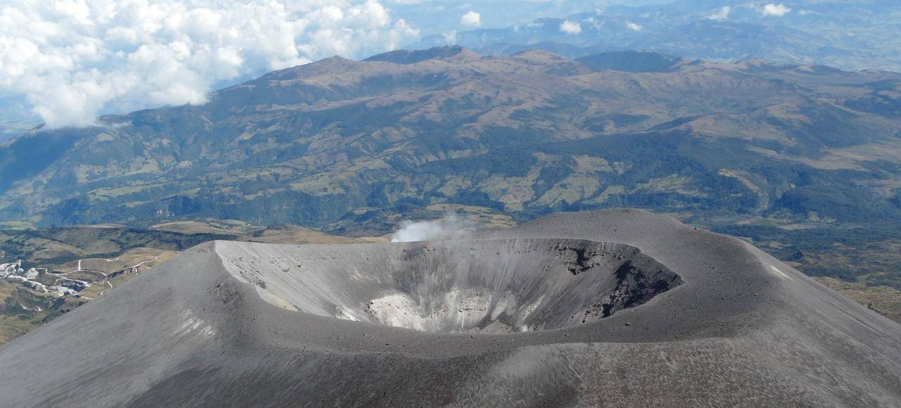
No changes were observed in the fumarole fields in the images captured by the visible and infrared spectrum webcams. In addition, degassing processes were observed in the lateral fumarole of the Puracé volcano crater and in the system of fissures and cavities that extends between the Curiquinga and Piocollo volcanoes.
In Yellow alert status, phenomena such as sporadic ash emissions (minor eruptions) may occur, the magnitude and effects of which are limited and the dispersion of ash depends on the wind direction, the presence of some incandescences, small explosions in the crater, low-energy thermal anomalies, noises, felt earthquakes, odors, precipitation of elemental sulfur near the crater and in hot springs and fumaroles, degassing in areas other than the crater. The formation of fissures and the appearance of minor mudflows, among others, are also observed.
Based on the above, the SGC recommends closely monitoring the evolution of volcanic activity through weekly bulletins and other information published on official channels, as well as complying with the instructions of local and departmental authorities and the National Disaster Risk Management Unit (UNGRD).
The alert status for volcanic activity remains at yellow alert status: active volcano with changes in the behavior of the base level of monitored parameters and other manifestations.
Source : SGC
Photo : National Park .
Philippines , Kanlaon :
The Philippine Institute of Volcanology and Seismology (PHIVOLCS) reported continuing eruptive activity at Kanlaon during 28 January-3 February. The seismic network recorded 5-16 daily volcanic earthquakes that, during 30 January-3 February, included 2-7 periods of volcanic tremor lasting two minutes to two hours and five minutes; volcanic tremor was not detected during 28-29 January. Average daily sulfur dioxide emissions ranged from 1,691 to 4,975 tonnes per day. Gas-and-steam emissions and those occasionally containing ash rose as high as 400 m above the summit and drifted NW, W, and SW. Weather clouds prevented views on 29 January.
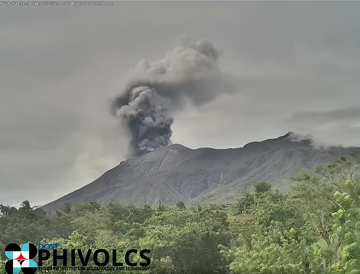
The eruption continued to impact residents. The National Disaster Risk Reduction and Management Council (NDRRMC) report issued at 0800 on 2 February stated that 9,834 people (3,107 families) were spread across 23 evacuation centers and another 8,388 people (2,662 families) were staying elsewhere. The Alert Level remained at 3 (on a scale of 0-5); the public was warned to stay 6 km away from the summit and pilots were warned not to fly close to the volcano.
Sources et photo : Philippine Institute of Volcanology and Seismology (PHIVOLCS), The National Disaster Risk Reduction and Management Council (NDRRMC) , GVP.