February 01 , 2025 .
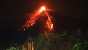
Alaska , Spurr :
Ongoing shallow earthquake activity continues at Mount Spurr Volcano. The rate of detected earthquakes was similar to previous weeks, with around 70 events located. A notable change in earthquake locations has occurred over the past few weeks with more events being located beneath Crater Peak, the flank vent south of the summit that was the site of the 1953 and 19992 eruptions. The Spurr monitoring network continues to experience weather-related telemetry issues that began on January 20—22 that likely contributed to fewer earthquake detections this week than if the network was complete. Ground deformation measured by a local network of Global Navigation Satellite System (GNSS) instruments shows slow, steady ground movement upward and outward since March 2024. An intrusion of magma beneath the volcano is the leading interpretation of the deformation data and the elevated seismicity. Clear views of the volcano in satellite and web camera images showed no unusual activity.

Steaming from the summit crater at Mount Spurr is visible during an overflight on May 14, 2024. The primary steam source is a fumarole (steam vent) inside of the summit crater, but a smaller fumarole is visible on the northeast crater rim. The snow is yellow around both fumaroles, where sulfur is precipitating on the snow from the plume.
AVO continues to closely monitor activity at Mount Spurr for signals that would indicate that the volcano is moving closer to an eruption using local seismic, infrasound, web camera, and GNSS stations along with regional infrasound, lightning networks and satellite data. Based on previous eruptions, additional changes in earthquakes, ground deformation, the summit lake, and fumaroles would be expected if magma begins to move closer to the surface. Therefore, it is very likely that if an eruption were to occur it would be preceded by additional signals that would allow advance warning.
Source : AVO
Photo : Haney, Matthew ( 05/2024)
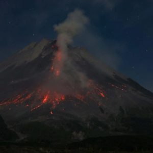
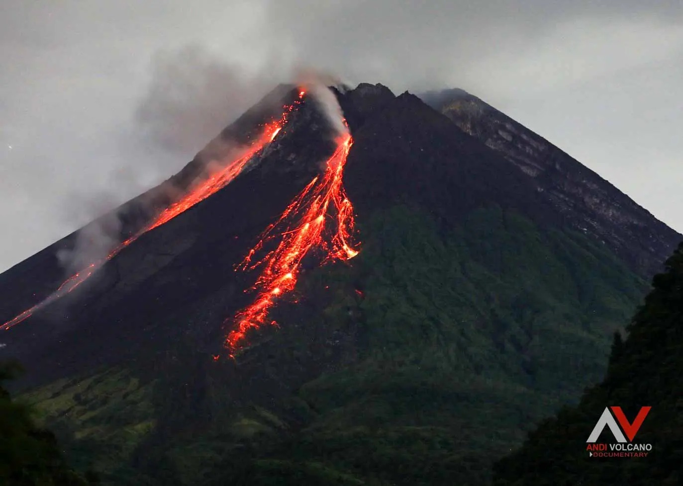
Indonesia , Merapi :
MERAPI ACTIVITY REPORT, January 24-30, 2025
Published on January 31, 2025
OBSERVATION RESULT
Visual
The weather around Mount Merapi is generally sunny in the morning and evening, while during the day and night it is hazy. White smoke, thin to thick, low to moderate pressure and 150 m high was observed from the Kaliurang Mount Merapi observation post on January 26, 2025 at 06:40 WIB. This week, lava avalanches were observed 57 times in the Southwest (upstream of Kali Bebeng) up to a maximum of 1,800 m, 18 times upstream of Kali Krasak up to a maximum of 1,800 m, and 31 times in the West (upstream of Kali Sat/Putih) up to a maximum of 2,000 m. The morphology of the Southwest dome was observed to have changed due to lava flow activity. For the Central dome, no significant morphological changes were observed. According to the analysis of aerial photos dated January 4, 2025, the volume of the Southwest dome was measured at 3,505,900 m3. The Central dome, on the other hand, measures 2,360,700 m3.
Seismicity:
This week, the seismicity of Mount Merapi recorded
148 Multi-phase (MP) earthquakes,
1,086 Avalanche earthquakes (RF),
10 Tectonic earthquakes (TT).
The intensity of earthquakes this week was lower than last week.
Deformation
The deformation of Mount Merapi monitored using EDM and GPS this week showed no significant changes.
Rainfall and Lahars
This week, it rained at Mount Merapi observation post with the highest rainfall intensity of 140 mm/hour for 42 minutes at Kaliurang post on 24 January 2025. There were no reports of additional discharge and lahars in the rivers that originate from Mount Merapi.
Conclusion
Based on the results of visual and instrumental observations, it is concluded that:
The volcanic activity of Mount Merapi is still quite high in the form of effusive eruptions. The activity status is defined at the « SIAGA » level.
Source : BPPTKG
Photo : Andi Volcanist.
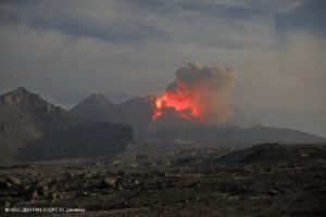
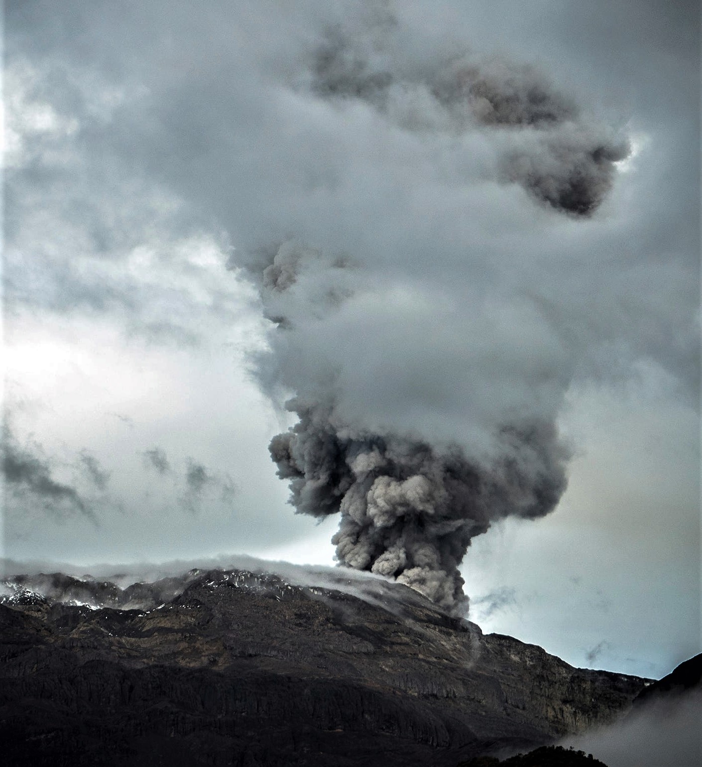
Colombia , Nevado del Ruiz :
Manizales, January 28, 2025, 6:00 p.m. .
Following the monitoring of the activity of the Nevado del Ruiz volcano, the Colombian Geological Survey (SGC), an entity attached to the Ministry of Mines and Energy, reports that:
During the week of January 21 to 27, 2025, the volcano continued to display unstable behavior. Compared to the previous week, the main variations in the monitored parameters were:
– Seismicity related to fluid dynamics in volcanic conduits associated with continuous ash emission and long-duration signals decreased and presented mainly low to sometimes moderate energy levels. In contrast to these seismic signals, those associated with the emission of pulsatile ash increased in the number of earthquakes recorded and in the seismic energy released, and showed energy levels ranging from low to moderate, and sometimes high. Thanks to the cameras (conventional or thermographic) used to monitor the volcano and to the reports of the officials of the Los Nevados National Natural Park and of the residents of the surroundings of the volcano, the emissions of gas and ash associated with some of these seismic signals have been confirmed. Changes in the relative temperature of the emitted material have also been observed during several recorded emissions of gas and ash.
– Seismic activity associated with rock fracturing processes inside the volcanic edifice increased in the number of recorded earthquakes and maintained similar levels in the released seismic energy. The earthquakes were of magnitude less than 1 (low energy level) and were located in the Arenas crater and in the northwest, northeast, east, southeast and south-southwest sectors of the volcano, at distances of up to 10 km from the crater with a predominance of distances less than 6 km from the Arenas crater. The depth of the earthquakes varied from less than 1 km to 8 km from the summit of the volcano.
During this week, seismic activity was also recorded in relation to the lava dome (protuberance or mound) located at the bottom of the crater. The energy levels of this seismicity were low.
– The emission of water vapor and gas, mainly sulfur dioxide (SO₂) into the atmosphere from the Arenas crater, showed variations, however, the SO₂ degassing rates were similar to those recorded the previous week. Satellite monitoring, carried out in a complementary manner to evaluate this parameter, showed significant SO₂ releases. – The maximum height of the gas and ash column was 1300 m vertically and 2600 m in dispersion. These values were measured at the summit of the volcano during the pulsatile emission of ash recorded on January 22 at 09:07. Due to the good atmospheric conditions, the gas and ash column associated with this emission was observed in several sectors of the municipalities located to the northeast and east of the volcano. As for the direction of dispersion of the column, it presented a predominant tendency towards the west and northwest of the volcano. Due to the persistence of winds in this direction and their high speeds, the material emitted during the ash emissions recorded during the week, as well as the material produced by the remobilization processes in the volcanic area, were dispersed causing ash fall in the municipalities of Manizales, Villamaría and Neira, in the department of Caldas. The seismic signals of January 22 at 09:50 and January 26 at 11:37 stand out because they are associated with some of the most significant ash falls that affected these municipalities during the week. – When monitoring thermal anomalies at the bottom of the Arenas crater, using satellite monitoring platforms, some reports of anomalies with low to moderate energy levels were obtained.
Source : SGC.
Photo : Álex Palacio ( 2022 )
Guatemala , Santiaguito :
Weather conditions: Clear
Wind: West
Precipitation: 0.0 mm.
Activity:
Degassing is observed above the crater. Weak to moderate explosions were recorded, ejecting columns of gas and ash that reached up to 900 meters above the crater and dispersed towards the southwest and west. At night and early in the morning, incandescence was observed in the crater of the Caliente dome and in the upper part of the lava flow in a west-southwest direction. Weak, moderate and some strong block avalanches are recorded on the lava flow, on the southern flank and on the southeast flank. Due to the wind direction, fine ash falls are expected on the farms near the west and northwest of the Caliente dome. The possibility of moderate to strong block and ash flows, as well as pyroclastic flows over long distances in different directions, is not excluded, therefore, one should not stay near or in river beds close to the slopes of the volcano.
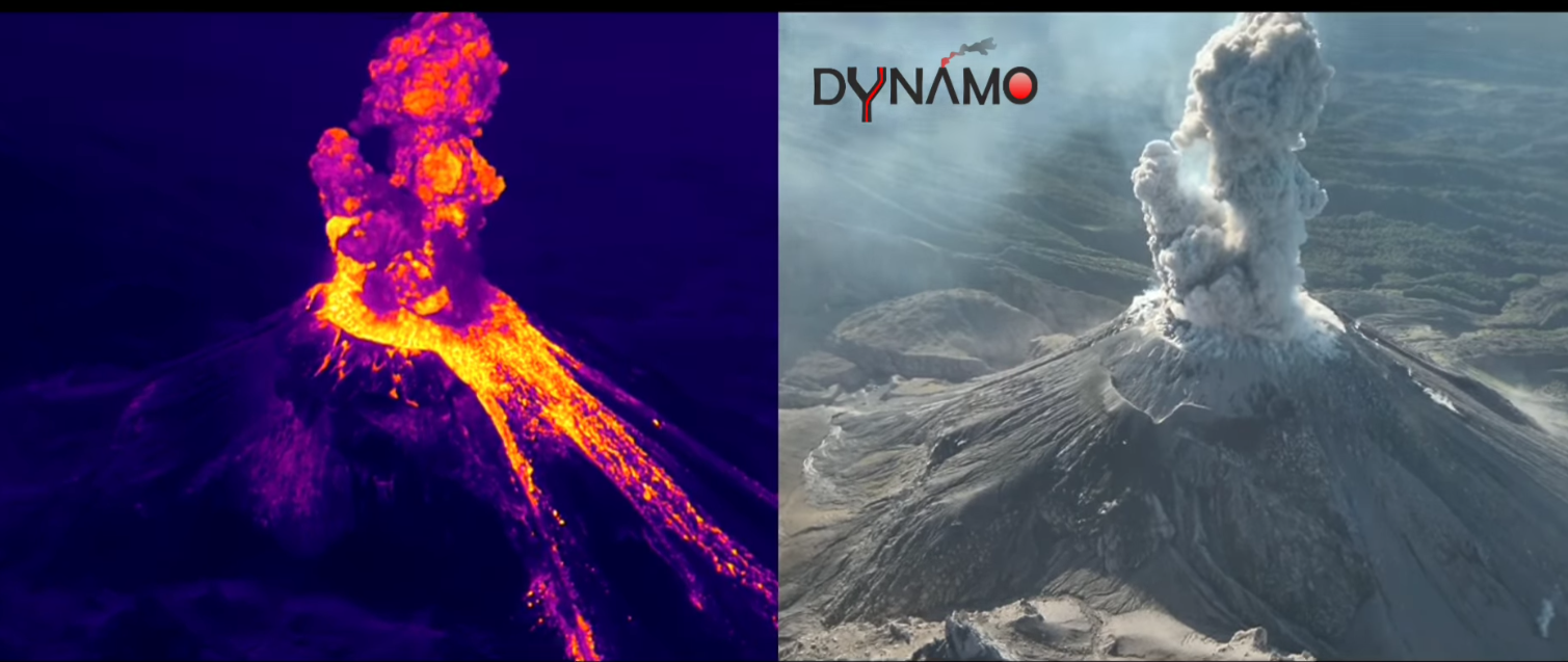
The active volcano Santiaguito in Guatemala, with split screen and drone shots (Dr. Riccardo Civico), both in the visible and with thermal camera.
The eruptive column rising from the summit crater area, after the explosion, certainly exceeds half a kilometer and we know from the INSIVUMEH bulletins that the maximum heights of the gas and ash column in January 2025 reached 1.2 km. The explosions occur from annular fractures present along the crater rim.
As already reported in last week’s post, inside the crater there is a lava dome, but in fact the eruptive history of the volcano tells us that we are facing a complex of dacitic lava domes (La Mitad, El Monje, Le Brujo, Le Caliente. These domes have been active since 1922 inside the crater formed on the southwest flank of the Santa Maria volcano, during the eruption of 1902. The most recent of the four vents that have developed since then is precisely « El Caliente » and is the one visible in the images, very active especially since 2016, with the formation of frequent « boulder avalanches » along the flanks of the volcano, even daily and multidirectional. The thermal camera clearly highlights the pyroclastic material along the slopes of the volcano and the block flows that push down from the edges of El Caliente. Pyroclastic flows can also develop from of higher energy explosions. In Guatemala, during the rainy season, lahars are also frequent.
The group of researchers from the National Institute of Geophysics and Volcanology INGV that is carrying out the latest measurements within the framework of the BACIO-DYNAMO project/experiment, continues to report a frequency of explosions varying between 7-8 minutes and one hour. Even in the last days of monitoring of the volcano, the exit velocities of pyroclastic fragments are confirmed to be lower than those of the explosions of basaltic magma.
Sources : Insivumeh, INGV .
Photo : INGV / Dr. Riccardo Civico.
Costa Rica , Rincon de la Vieja :
Latitude: 10.83°N;
Longitude: 85.34°W;
Elevation: 1916 m.a.s.l.
Current Activity Level: Warning
Eruptive activity remains low with a small eruption occurring on 27 January. In addition, a low-energy exhalation rich in water vapor, aerosols, and volcanic gases was recorded on 23 January. Background seismic tremor remains low in amplitude compared to the last two weeks. The dominant frequency range of this tremor is observed between 4 and 6.5 Hz.
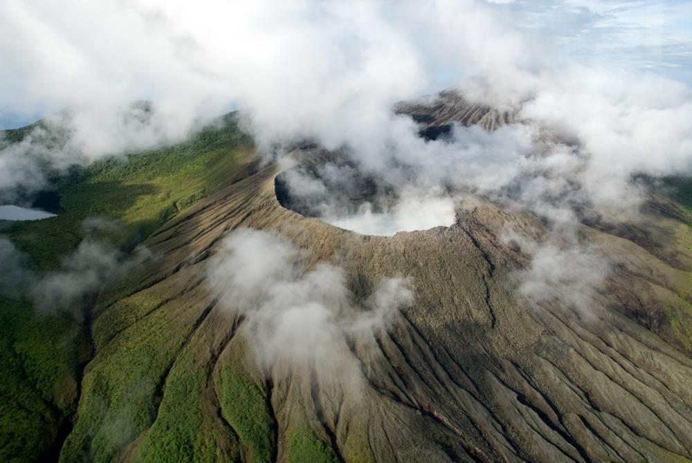
The occurrence of long-period « tornillos » type signals continues. The dominant frequency of « tornillos » shows a slight decreasing trend in recent weeks. A volcano-tectonic earthquake is recorded near the crater. Geodetic observations show stability at the base and summit. During the past week, the average SO2 flux was 286 ± 138 t/d, slightly lower than the previous week 363 ± 153 t/d. The MultiGAS station records low gas concentrations. The OMI instruments on the SENTINEL satellite have not detected SO2 in the atmosphere since 26 December 2024.
Source et photo : Ovsicori.