October 07 , 2024 .
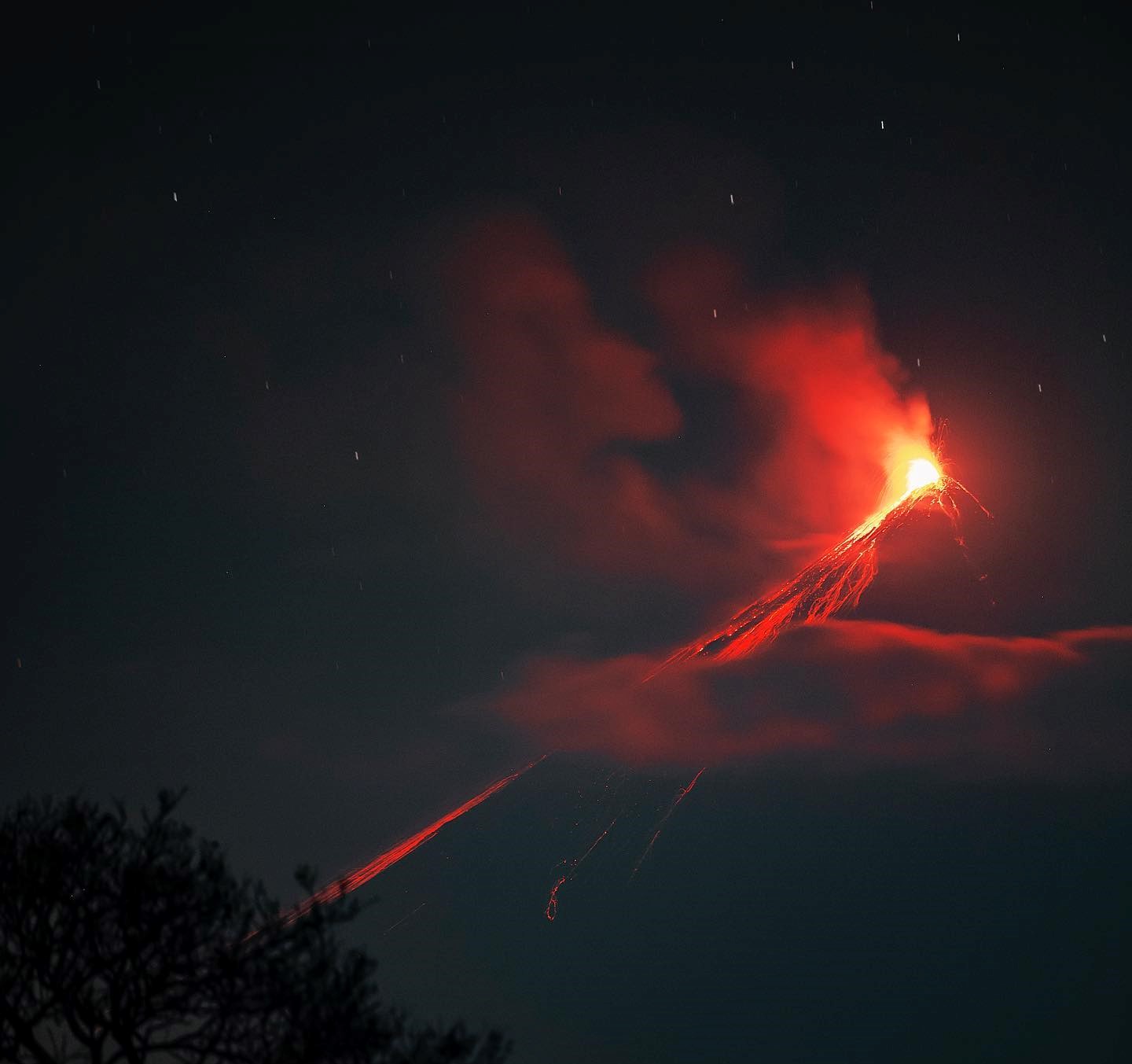
Italy , Stromboli :
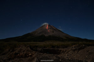
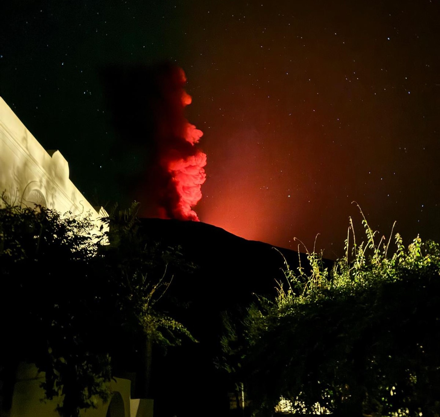
Statement on the activity of Stromboli, 06 October 2024, 02:23 (00:23 UTC) .
The National Institute of Geophysics and Volcanology, Osservatorio Etneo, reports that at 00:20 GMT a major explosion was detected by surveillance cameras.
Statement on the activity of Stromboli, 06 October 2024, 02:54 (00:54 UTC) .
The National Institute of Geophysics and Volcanology, Osservatorio Etneo, reports that, from the analysis of the images from the surveillance cameras, the appearance of a major explosion produced by the area of the North crater was observed at 00:17:23 UTC.
The event developed as a sequence and produced fallout of materials along the Scaria del Fuoco.
From a seismic point of view, at 00:17 UTC, all the stations of Stromboli recorded a seismic signal of amplitude higher than normal. The average amplitude of the tremor reached a very high level during the paroxysmal event, followed by a rapid decrease until reaching the current high level. The frequency of occurrence of explosion earthquakes does not present significant variations.
Concerning the deformations, the TDF inclinometric station is being updated. The GNSS network does not present significant variations.
Statement on the activity of Stromboli, 06 October 2024, 03:32 (01:32 UTC) .
The National Institute of Geophysics and Volcanology, Osservatorio Etneo, reports that the major event was followed by the beginning of a spattering activity in the area of the North crater which, intensifying around 00:25, evolved into an effusive activity with the production of a lava flow that develops along the ravine located in the Sciara del Fuoco and produced by the eruptive activity of July. Currently, the lava flow front is located on the upper part of the Sciaria.
From a seismic point of view, the average amplitude of the volcanic tremor is currently average. The amplitude of the explosion earthquakes remains low.
Regarding the deformations, the GNSS network does not show any significant variations.
The TDF inclinometer station, after the modest variations in the order of the micro-radiant fraction recorded during the previous major explosive event, does not currently show significant variations.
Statement on the activity of Stromboli, 06 October 2024, 09:58 (07:58 UTC) .
The National Institute of Geophysics and Volcanology, Osservatorio Etneo, reports that according to the analysis of the images from the surveillance cameras, the effusive activity of the lava overflow from the North Crater area reported in the press release of 6 October at 01:30 UTC has gradually exhausted itself in the early morning. Projection activity persists with variable regime and intensity.
From a seismic point of view, since the major explosion at 00:17 UTC today, the average amplitude of the volcanic tremor has fluctuated between the average value and the high value. Currently, the amplitude of the tremors is average. The amplitude of the explosion earthquakes remains low.
Concerning the deformations, the GNSS network and the TDF inclinometer station do not show significant variations.
Further updates will be communicated shortly.
Source : INGV.
Photo : @alessandraarati via Stromboli stati d’animo.
Indonesia , Lewotobi Laki-laki :
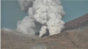
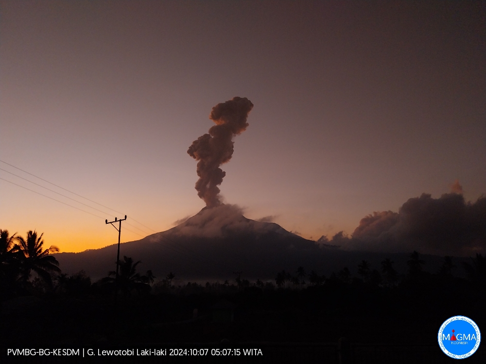
An eruption of Lewotobi Laki-laki occurred on Monday, October 7, 2024 at 05:03 WITA with the height of the ash column observed at ± 800 m above the summit (± 2384 m above sea level). The ash column was observed to be gray in color with a thick intensity, oriented towards the southwest. This eruption was recorded on a seismograph with a maximum amplitude of 4.4 mm and a duration of 279 seconds.
VOLCANO OBSERVATORY NOTICE FOR AVIATION – VONA
Issued : October 07 , 2024
Volcano : Lewotobi Laki-laki (264180)
Current Aviation Colour Code : ORANGE
Previous Aviation Colour Code : orange
Source : Lewotobi Laki-laki Volcano Observatory
Notice Number : 2024LWK599
Volcano Location : S 08 deg 32 min 20 sec E 122 deg 46 min 06 sec
Area : East Nusa Tenggara, Indonesia
Summit Elevation : 5069 FT (1584 M)
Volcanic Activity Summary :
Eruption with volcanic ash cloud at 21h03 UTC (05h03 local).
Volcanic Cloud Height :
Best estimate of ash-cloud top is around 7629 FT (2384 M) above sea level or 2560 FT (800 M) above summit. May be higher than what can be observed clearly. Source of height data: ground observer.
Other Volcanic Cloud Information :
Ash cloud moving to southwest. Volcanic ash is observed to be gray. The intensity of volcanic ash is observed to be thick.
Remarks :
Eruption recorded on seismogram with maximum amplitude 4.4 mm and maximum duration 279 second.
Source et photo : Magma Indonésie.
Colombia , Cerro Machín :
Manizales, October 1, 2024, 7:00 p.m.
From the monitoring of the activity of the Cerro Machín volcano, the Colombian Geological Survey (SGC), an entity attached to the Ministry of Mines and Energy, reports that:
For the week of September 24 to 30, 2024, the recording of seismicity associated with the fracturing of rocks inside the volcanic edifice continued. Compared to the previous week, this activity decreased in the number of earthquakes recorded and in the seismic energy released. The earthquakes recorded were of magnitudes less than 1 (low energy level) and were located on the western flank of the volcano (from northwest to south-southwest), at distances of less than 2 km. The depths of the earthquakes varied between 2 km and 5 km from the summit of the volcano.
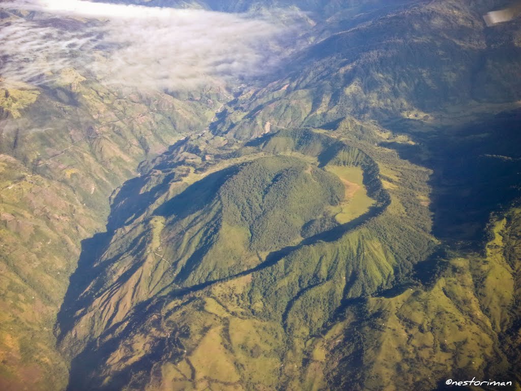
The other parameters measured and used for the diagnosis of volcanic activity have not presented significant changes during the period evaluated.
Based on the above, the SGC recommends to closely monitor the evolution through the weekly bulletins and other information published through our official channels, as well as the instructions of the local and departmental authorities and the National Unit for Disaster Risk Management (UNGRD).
The alert status due to volcanic activity remains Yellow: active volcano with changes in the behavior of the basic level of the monitored parameters and other manifestations.
Source : SGC
Photo : Nestoriman
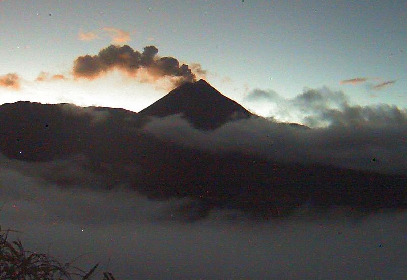
Ecuador , El Reventador :
DAILY REPORT ON THE STATE OF THE REVENTADOR VOLCANO , Sunday, October 06, 2024.
Information Geophysical Institute – EPN.
Surface Activity Level: High , Surface Trend: No Change
Internal Activity Level: Moderate , Internal Trend: No Change
From October 05, 2024, 11:00h to October 06, 2024, 11:00h:
Seismicity:
The count of seismic events recorded at the station is detailed below.
Explosion (EXP) 95
Long Period (LP) 17
Emission Tremor (TREMI) 5
Harmonic Tremor (TRARM) 3
Rainfall / Lahars:
No rain has been recorded in the volcano area. **In the event of heavy rain, it could remobilize the accumulated materials, generating mud and debris flows that would descend the sides of the volcano and flow into adjacent rivers.
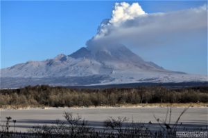
Emissions/ash column:
Due to transmission problems, it was not possible to observe emissions through the surveillance camera system. On the other hand, thanks to the GOES-16 satellite system, an emission of gas and ash was detected at a height of 800 meters above the crater level in a northwest direction. Associated with this activity, the VAAC agency in Washington published four emission reports with heights of 1000 meters above the crater level in north and northwest directions.
Other monitoring parameter:
The FIRMS satellite system recorded 1 thermal anomaly and the MIROVA-VIIRS satellite system recorded 1 thermal anomaly, during the last 24 hours.
Observation:
From yesterday until the closing of this report, thanks to the weather forecast platforms, it was observed that the volcano remained completely cloudy most of the time.
Alert level: Orange
Source : IGEPN
Photo : Archive IGEPN. ( 2021) .
Guatemala , Fuego :
Atmospheric conditions: Clear
Wind: Southeast.
Precipitation: 3.8 mm.
Activity:
INSIVUMEH seismic stations show weak to moderate explosions, occurring at a rate of 3 to 9 per hour, lifting columns of gray gas and ash to heights between 4,500 and 4,800 meters above sea level (14,763 to 15,748 feet), which move west and northwest carrying the ash up to 30 kilometers or more. The explosions have produced weak to moderate avalanches that reach vegetation and at night incandescent pulses 100 to 150 meters above the crater.
Due to the wind direction, a small fall of fine ash may occur in Sangre de Cristo, Santa Emilia, Yepocapa, Ojo de Agua, Panimache I and II, Quisaché, Palo Verde, among others. Regarding explosive activity, follow the recommendations described in the special bulletin BEFGO-003-2024. In the afternoon and evening, moderate and heavy rains will continue in the volcanic area, so lahars could descend. It is recommended to take precautions when passing vehicles through the ravines.
Source : Insivumeh.
Photo : Diego Rizzo ( 03/2022)