April 29 , 2022.
Indonesia , Batu Tara :
VOLCANO OBSERVATORY NOTICE FOR AVIATION – VONA
Issued : April 28 , 2022
Volcano : Batutara (264260)
Current Aviation Colour Code : YELLOW
Previous Aviation Colour Code : yellow
Source : Batutara Volcano Observatory
Notice Number : 2022TAR03
Volcano Location : S 07 deg 47 min 31 sec E 123 deg 34 min 44 sec
Area : East Nusa Tenggara, Indonesia
Summit Elevation : 2394 FT (748 M)
Volcanic Activity Summary :
The eruption has not yet occurred but an increase in degassing has been observed at 07h53 UTC (14h53 local).
Volcanic Cloud Height :
Best estimate of ash-cloud top is around 5594 FT (1748 M) above sea level, may be higher than what can be observed clearly. Source of height data: ground observer.
Other Volcanic Cloud Information :
Ash-cloud moving to west
Remarks :
No seismic observations.
Source : Magma Indonésie .
Photo : Fady Kamar
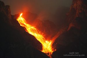
Hawaii , Kilauea :
19°25’16 » N 155°17’13 » W,
Summit Elevation 4091 ft (1247 m)
Current Volcano Alert Level: WATCH
Current Aviation Color Code: ORANGE
Activity Summary:
The summit eruption of Kīlauea Volcano, within Halemaʻumaʻu crater, continued over the past 24 hours. All recent activity has been confined to the crater and current data indicate that this scenario is likely to continue. No significant changes have been noted in the summit or East Rift Zone.
Halemaʻumaʻu crater Lava Lake Observations:
Eruption of lava from the western vent into the active lava lake and onto the crater floor continued over the past 24 hours. The active part of the lava lake showed continuous surface activity. The lake level had minor fluctuations throughout the day, and has dropped slightly below the rim this morning with summit deflation. Sporadic breakouts also continue along the margins of the crater. Since the beginning of this eruption on September 29, 2021, the crater floor has seen a total rise of about 99 meters (325 feet).
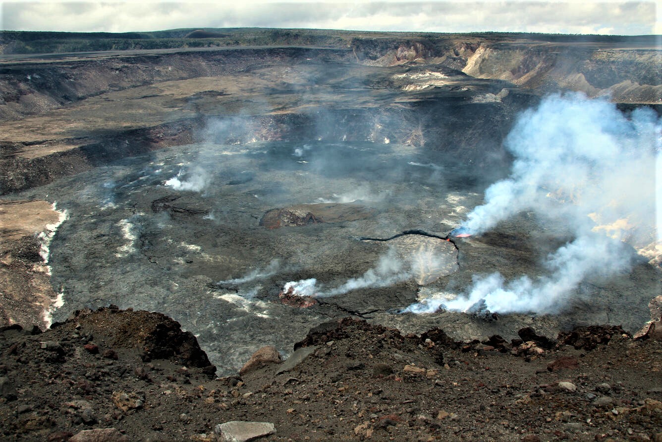
Summit Observations:
Summit tiltmeters recorded the onset of deflationary tilt this morning at about 3 a.m. Volcanic tremor remains above background levels. A sulfur dioxide (SO2) emission rate of approximately 4,300 tonnes per day (t/d) was measured on April 27, 2022.
Source : HVO
Photo : USGS / N. Deligne.
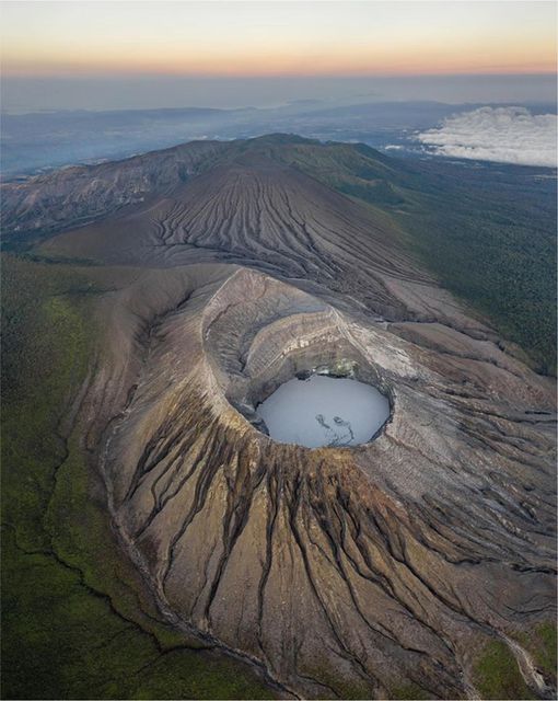
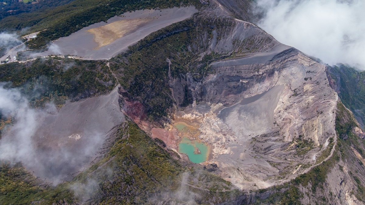
Costa Rica , Turrialba / Poas / Rincon de la Vieja / Irazu / Arenal :
Turrialba Volcano
Latitude: 10.025°N;
Longitude: 83.767°W;
Altitude: 3340m.
Current activity level: warning
Possible manifestations: Small eruptions, projections or geysers, significant emission of acid gases, rise in temperature (incandescence), seismic swarms or volcanic tremor, slight inflation-extension of the volcanic edifice.
The last phreatic eruption occurred on February 28. The downward trend in low frequency activity has been confirmed. An increase in short modulation tremors (broadband and harmonics) was observed. Several VT-type events have been recorded, some of magnitude greater than 2, superficial at the top, and an interesting concentration of earthquakes in the Capellades fault, between the Irazú and Turrialba volcanoes. Geodetic monitoring shows that the Irazú-Turrialba massif remains slightly contracted. Degassing remains stable, with a weekly average of CO2/SO2 of 21.4 +/- 2.3 and H2S/SO2 of 0.19 +/- 0.07, values similar to those of the previous week. The SO2 flux remains stable despite high variability this week (93 +/- 79 t/d).
Poas Volcano
Latitude: 10.2°N;
Longitude: 84.233°W;
Altitude: 2780m.
Current activity level: warning
Possible manifestations: Small eruptions, gushes or geysers, significant emission of acid gases, rise in temperature (incandescence), seismic swarms or volcanic tremor, slight inflation-extension of the volcanic edifice.
Since the April 6 landslide and decompression, several new landslides and small hydrothermal explosions have been observed and recorded on the collapsing vertical wall.
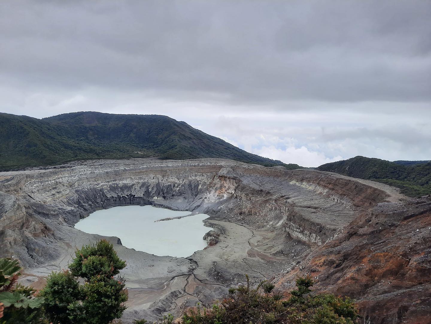
Due to the increase in normal ambient noise for this time of year and the low amplitude of seismic signals, the number of LP-type events has decreased this week. A few short tremors were detected. The distal VT-type events were located in the Cinchona fault zone and near the Platanar-Porvenir massif and the proximal VT-type events under the crater, about 3 km deep. The DSAR has been rising since March and is back to a level not seen for a year.
The geodetic network does not show any significant deformation. Gas monitoring indicates that gas ratios remain relatively stable, with a weekly SO2/CO2 average of 0.47 +/- 0.14, similar to the previous week, and the H2S/SO2 ratio has a value of 0 .02 +/- 0.3 . The SO2 concentration at the Mirador showed several peaks, notably on Monday April 18 (> 5 ppm) due to the absence of wind. The SO2 flow is stable with an average value of 60 +/- 26 t/d. The level of the lake is stable, its temperature too (~ 37°C). The fumarolic fields do not show any changes except for the site of the old « orange fumarole » which is in the process of gravitational stabilization. Thermal anomalies were observed on the vertical wall adjacent to the collapsed site and a fumarolic field is developing above the deposit of material in the lake. The southern edge of the lake is fractured, so we can expect a collapse of the lake wall in the future, similar to what happened in November 2021.
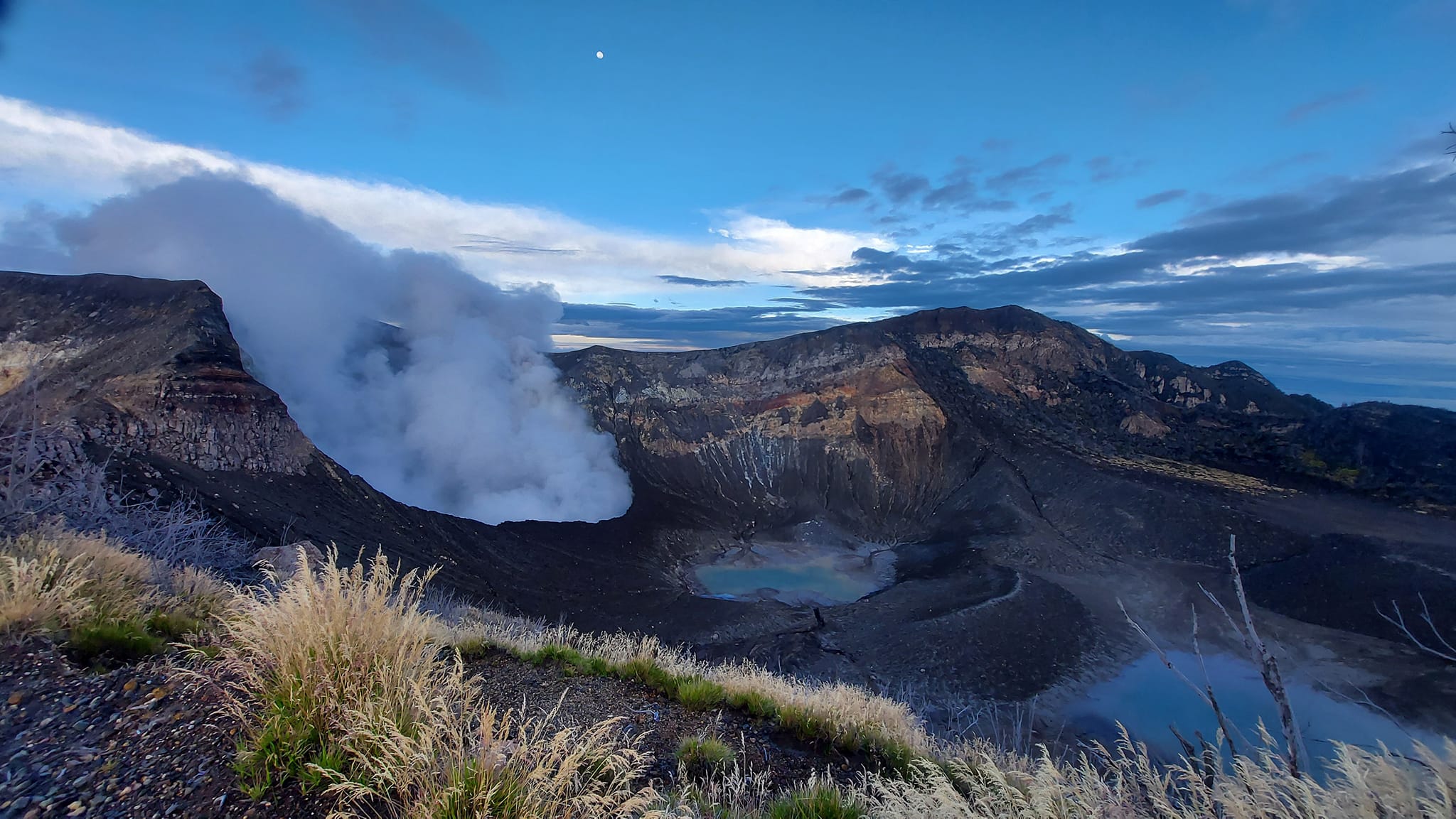
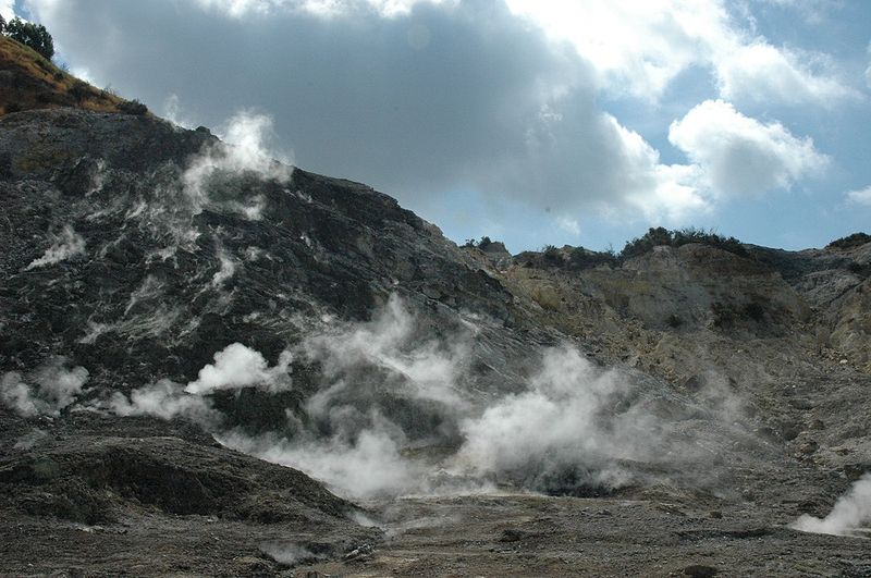
Rincon de la Vieja Volcano
Latitude: 10.83°N;
Longitude: 85.324°W;
Altitude: 1895m.
Current activity level: warning
Possible manifestations: Small eruptions, gushes or geysers, significant emission of acid gases, increase in temperature (incandescence), seismic swarms or/volcanic tremor, slight inflation-extension of the volcanic edifice.
There were 4 phreatic eruptions during the first week of April, none of them being strong enough to generate lahars in the following hours. The tremor has disappeared, the number of LP type events is maintained, “Tornillos” type events of high amplitude and low amplitude VT type events are recorded.
The average frequency has increased. ICE colleagues traveled to the crater this week and observed a low lake level and no active convection cells. Geodetic monitoring shows a slight uplift of the base and the summit.
Irazu Volcano
Latitude: 9.979°N;
Longitude: 83.852°W;
Altitude: 3432 m.
Current activity level: Calm
Possible manifestations: tectonic earthquakes, occasional low-frequency earthquakes, hydrothermal activity (fumaroles, diffuse gas, hot springs, etc.).
VT-type events were recorded mainly between the Turrialba and the Irazú (Capellades fault). No significant change in gas measurements has been observed in the diffuse degassing area on the volcano’s northern flank over the past month.
Arenal Volcano
Latitude: 10.463°N;
Longitude: 84.703°W;
Altitude: 1670m
Current activity level: Calm
Possible manifestations: tectonic earthquakes, occasional low frequency earthquakes, hydrothermal activity (fumaroles, diffuse gas, hot springs, etc.).

Small VT-type events were recorded below the summit of the volcano on April 9 and 13, some very shallow.
Source : Ovsicori.
Photos : parque nacional , New Summit Academy Costa Rica , Soy Tico , RSN.
Italy , Campi Flegrei :
Weekly Bulletin, from April 18, 2022 to April 24, 2022. (Published April 26, 2022)
ACTIVITY STATUS SUMMARY
In the light of the surveillance data, it is highlighted:
1) SEISMOLOGY: During the week of April 18 to 24, 2022, 66 earthquakes were recorded in the Campi Flegrei area (Mdmax = 2.9 ± 0.3).
2) DEFORMATIONS: The average lifting speed value in the maximum deformation zone from December 2021 is about 13 ± 2 mm/month. The lift recorded at the RITE GPS station has been around 88.5 cm since January 2011.
3) GEOCHEMISTRY: The soil CO2 fluxes measured last week did not show any significant changes. The temperature sensor installed in a fumarole 5 meters from
the main Pisciarelli fumarole showed an average value of ~95°C with a minimum value of ~87°C in conjunction with rainfall events.
SEISMOLOGY
In the week of April 18 to 24, 2022, in the Campi Flegrei region, 66 earthquakes were recorded with -0.8≤Md≤2.9 (± 0.3).
It was possible to determine the hypocentral parameters of 44 of the recorded events.
Source : INGV.
Photo : Manuel Mauer / Wikipédia.
Vanuatu , Ambae :
AMBAE VOLCANO ALERT BULLETIN , 28th April 2022 at 12:01 pm:
The Volcanic Alert Level remains at Level 2.
The volcano activity consists of emission of steam and explosions of wet tephra ejected above the lake surface but confined within the caldera while only very light ash is deposited on villages located close to the volcano, especially those exposed to wind directions.
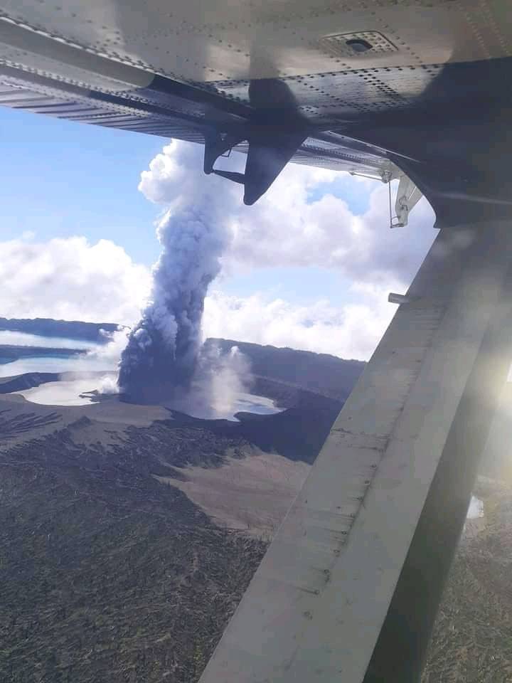
New observations confirmed that the volcanic cone has built up inside Lake Voui and Ambae volcano continues to emit volcanic gas and ash contained within Lake Vui, consistent with the activity of the Ambae volcano under Volcanic Alert Level 2 indicating ‘Major level of unrest; the Danger area remains at 2 km around the volcanic vents and within the area of flowing creeks.
Source : Geohazard.
Photo : Johnston Aga