April 22 , 2022.
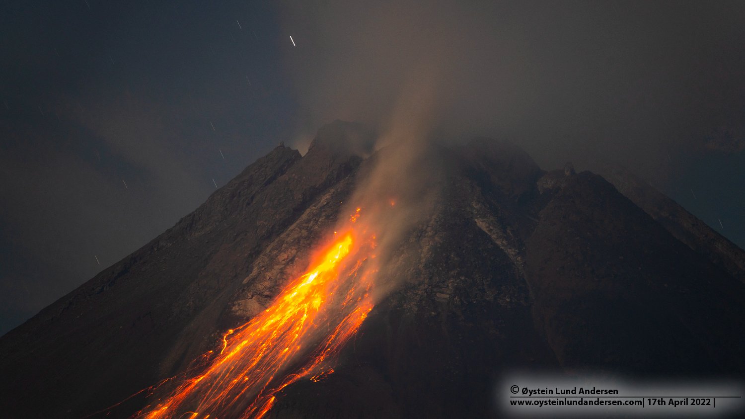
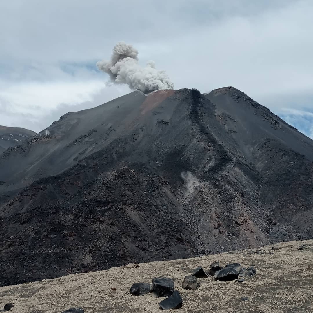
Indonesia , Merapi :
Merapi activity report from April 15 to 21, 2022.
– This week, there was 1 avalanche of hot clouds towards the southwest (upstream of the Bebeng River) with a slip distance of 2,000 m. Lava avalanches were observed 150 times to the southwest, descending the Bebeng River with a maximum slip distance of 2,000 m.
– In the Southwest dome, there is no change in the height of the dome. For the middle dome, no significant morphological change was observed. According to photo analysis, the volume of the southwest lava dome is 1,672,000 m3 and the central dome is 2,582,000 m3.
Seismicity:
This week, the seismicity of Mount Merapi recorded:
1 hot cloud avalanche (APG),
12 shallow volcanic earthquakes (VTB),
86 multi-phase earthquakes (MP),
889 avalanche earthquakes (RF),
9 emission earthquakes (DG),
7 tectonic earthquakes (TT).
– The intensity of seismicity this week is still quite high.
Mount Merapi’s deformation that was monitored using EDM this week showed a distance shortening rate of 0.2 cm/day.
– Rainfall intensity was 74 mm/hour for 80 minutes at Kaliurang Post on April 16, 2022. There was landslide in Woro, Gendol and Krasak rivers on April 19, 2022.
Conclusion:
1. The volcanic activity of Mount Merapi is still quite high in the form of effusive eruption activity. The state of the activity is defined at the « SIAGA » level.
2. The current potential danger is lava avalanches and hot clouds in the South-South-West sector covering the Boyong River for a maximum of 5 km, the Bedog River, Krasak, Bebeng for a maximum of 7 km. The Southeast sector covers the Woro River for a maximum of 3 km and the Gendol River for a maximum of 5 km. Meanwhile, the ejection of volcanic material in the event of an explosive eruption can reach a radius of 3 km around the summit.
Source : BPPTKG.
Photo : Oystein Lund Andersen.
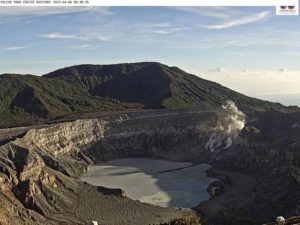
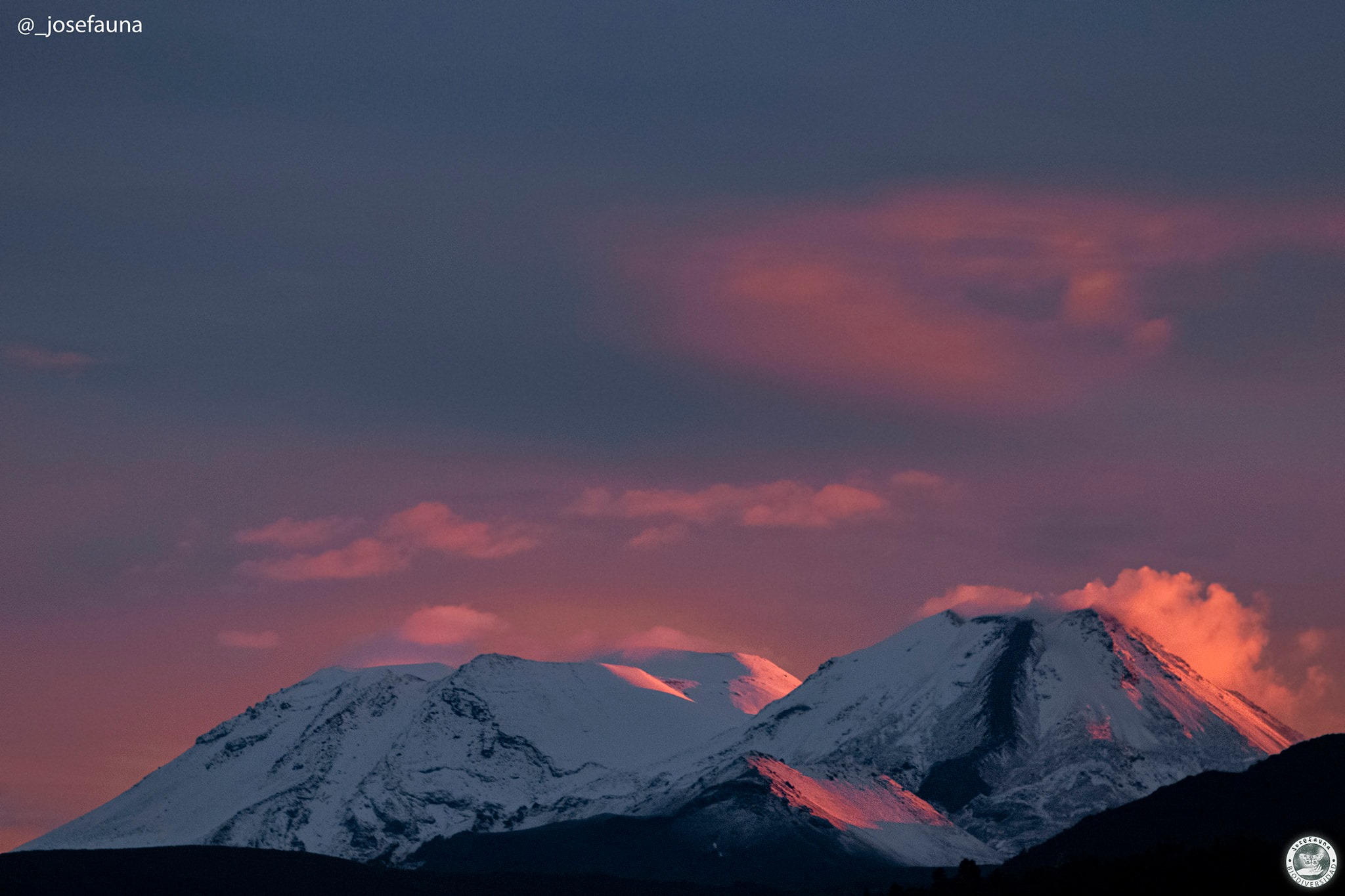
Chile , Nevados de Chillan :
Nevados de Chillán Volcanic Complex
SEISMOLOGY
Volcano-tectonic (VT) seismicity showed a total of 29 events caused by brittle fracture processes; the most energetic had a local magnitude (ML) equal to 2.0, located 3.7 km east-south-east of the volcanic edifice, with a depth of 3.5 km from the summit. This seismicity, which was spatially and temporally linked in the previous phases of this eruptive cycle with changes in the deformation of the volcanic edifice, remains at low levels compared to periods of greater activity.
Long period (LP), explosion (EX) and tremor (TR) seismicity continues to be recorded, associated with fluid dynamics within the volcanic system. 795 LP-type earthquakes were classified, including 243 linked to explosions at surface level, due to the presence of acoustic waves and/or gaseous emissions, often with the addition of particulate matter. The size of the largest LP earthquake estimated from the reduced displacement parameter (DR) reached a value equal to 292 cm2, and was associated with an explosion with the emission of incandescent material with a fissural distribution at its exit. Regarding TR type seismicity, 272 episodes were identified, the most important of which reached a DR of 91 cm2. The daily energy levels observed for these events remained at a level considered low compared to periods of greatest eruptive activity.
FLUID GEOCHEMISTRY
Data on sulfur dioxide (SO2) emissions obtained by optical differential absorption spectroscopy (DOAS) equipment, corresponding to the Philippi and Chillán stations, installed 1.5 km to the South-South-East (SSE ) and 2.7 km east-southeast (ESE) of the active crater, respectively, showed an average value of 595 ± 80 t/d, with a maximum daily value of 1071 t/d, recorded on April 9. An increase in SO2 levels is observed, consistent with the presence of a new effusive body inside the active Nicanor crater.
No anomalies were reported in the emissions of sulfur dioxide (SO2) into the atmosphere in the area near the volcanic complex.
SATELLITE THERMAL ANOMALIES
A thermal alert was recorded in the area associated with the volcanic complex during the period, with a maximum Volcanic Radiative Power (VRP) of 14 MW on April 3, a value considered moderate according to data processed by the Middle Infrared of Observation of Volcanic Activity. (MIROVA, http://www.mirovaweb.it/).
At the same time, according to the analytical processing of satellite images (Sentinel 2-L2A in combination of false color bands), luminance anomalies were observed during days 03, 05, 08, 13 and 15 April with a radiation surface maximum estimated at 2700 m2 on 05 April.
GEODESY
According to the data provided by the geodetic network composed of 5 GNSS and 3 electronic inclinometers, which makes it possible to measure the deformation in the complex, displacements which clearly mark a deflationary trend have been observed in the GNSS stations, indicating a maximum of subsidence at the Northwest of the active crater.
SURVEILLANCE CAMERAS
Explosive surface activity was recorded from the active crater, with the generation of eruptive columns dominated by water vapor and occasional columns with moderate pyroclastic content. The highest height detected corresponds to 1640 m above the crater on April 15. During this fortnight, there was only one explosion accompanied by pyroclastic flows, which affected the North and North-East slopes, with a maximum range of 500 m from the edge of the crater and concentrating mainly in the ravines that descend from the summit of the active crater. The observed incandescence remained at low to moderate levels, being generally observed as a point focus in the crater area. Both in daytime and nighttime activity, fissure-type emissions were observed inside the crater with an approximate North-South trajectory.
Source : Sernageomin
Photos : Sernageomin , Josefauna.
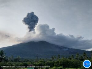
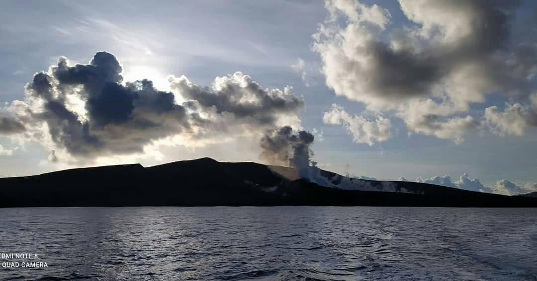
Indonesia , Anak Krakatau :
VOLCANO OBSERVATORY NOTICE FOR AVIATION – VONA
Issued : April 23 , 2022
Volcano : Anak Krakatau (262000)
Current Aviation Colour Code : ORANGE
Previous Aviation Colour Code : orange
Source : Anak Krakatau Volcano Observatory
Notice Number : 2022KRA42
Volcano Location : S 06 deg 06 min 07 sec E 105 deg 25 min 23 sec
Area : Lampung, Indonesia
Summit Elevation : 502 FT (157 M)
Volcanic Activity Summary :
Eruption with volcanic ash cloud 07h34 UTC (14h34 local). Eruption and ash emission is continuing.
Volcanic Cloud Height :
Best estimate of ash-cloud top is around 10102 FT (3157 M) above sea level, may be higher than what can be observed clearly. Source of height data: ground observer.
Other Volcanic Cloud Information :
Visuals directly from the cctv were observed eruptions with the color of the thick black eruption smoke 3000m from the top of the volcano, the wind direction slowly to the southwest and south.
Remarks :
Seismic activity is characterized by continuous volcanic tremor with overscale amplitude. Lava flow is observed through the west direction of the anak krakatau crater.
VOLCANO OBSERVATORY NOTICE FOR AVIATION – VONA
Issued : April 24 , 2022
Volcanic Activity Summary :
Eruption with volcanic ash cloud at 05.00 UTC (12.00 local). Eruption and ash emission is continuing.
Volcanic Cloud Height :
Best estimate of ash-cloud top is around 10102 FT (3157 M) above sea level, may be higher than what can be observed clearly. Source of height data: ground observer.
Other Volcanic Cloud Information :
Visuals directly from the cctv were observed eruptions with the color of the thick white-grey-black eruption smoke 3000m from the top of the volcano, the wind direction slowly to the south-southwest.
Remarks :
Seismic activity is characterized by continuous volcanic tremor. recorded on seismogram with maximum amplitude 55 mm.
Source : Magma Indonésie.
Photos : PVMBG , krakatau_ca_cal
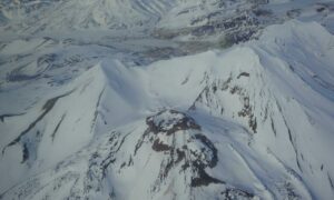
Hawaii , Kilauea :
19°25’16 » N 155°17’13 » W,
Summit Elevation 4091 ft (1247 m)
Current Volcano Alert Level: WATCH
Current Aviation Color Code: ORANGE
Activity Summary:
The summit eruption of Kīlauea Volcano, within Halemaʻumaʻu crater, continued over the past 24 hours. All recent activity has been confined to the crater and current data indicate that this scenario is likely to continue. No significant changes have been noted in the summit or East Rift Zone.
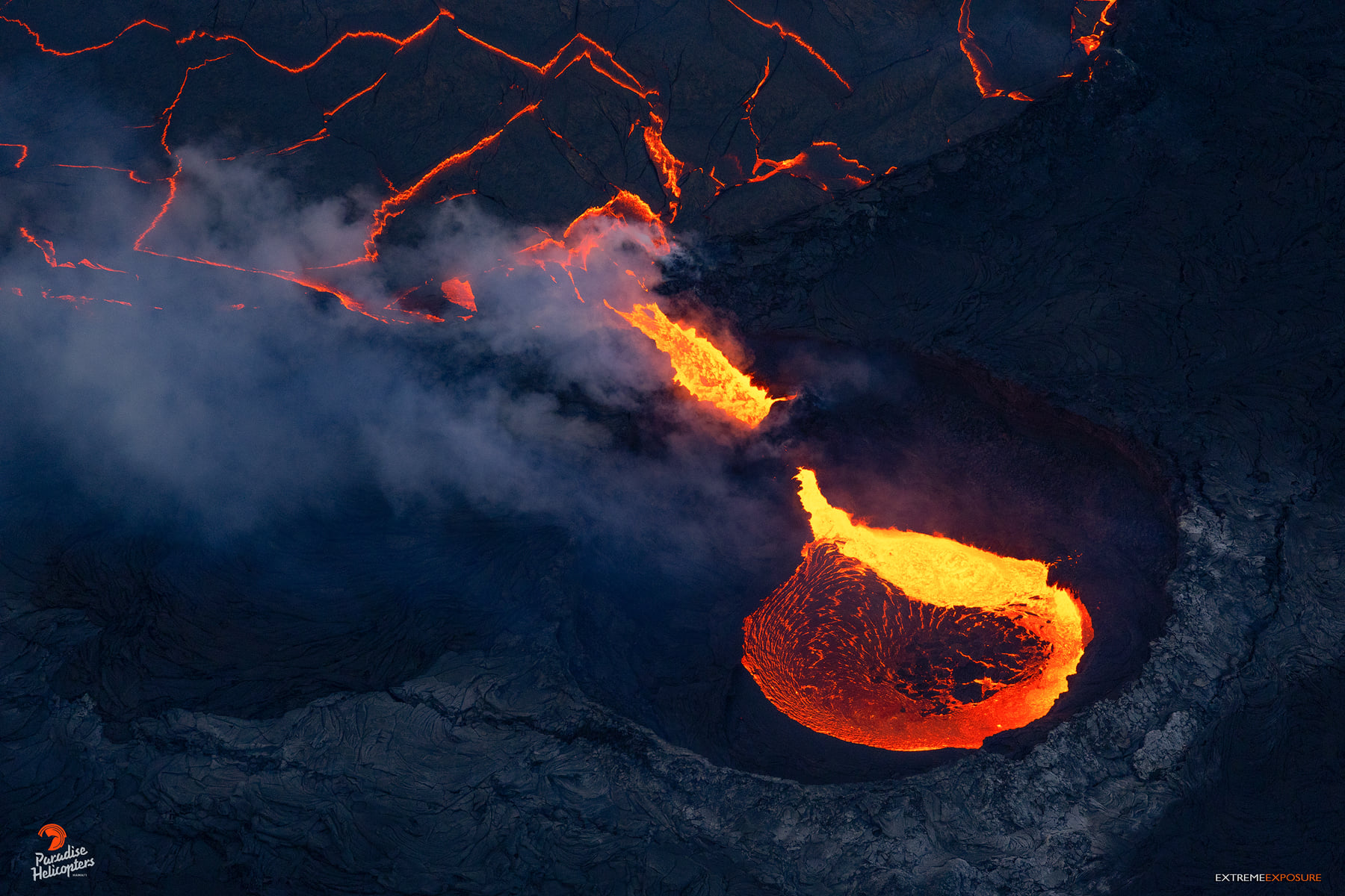
Halemaʻumaʻu crater Lava Lake Observations:
Eruption of lava from the western vent into the active lava lake and onto the crater floor continued over the past 24 hours. The active part of the lava lake showed continuous surface activity and the lake height rose to just below its rim together with the return of inflationary tilt last night. Breakout activity has been minimal, but continues along the margins of the crater to the north, northeast, and south. Since the beginning of this eruption on September 29, 2021, the crater floor has seen a total rise of about 99 meters (325 feet). The volume of lava effused since the beginning of this eruption was approximately 66 million cubic meters (18 billion gallons) as measured on April 6, 2022.
Summit Observations:
Summit tiltmeters began recording inflationary tilt starting at about 11:30pm yesterday evening, consistent with the inflationary phase of a summit Deflation-Inflation (DI) event. The inflationary phase of the DI event is still on-going this morning but should conclude by this afternoon. Volcanic tremor remains above background levels. A sulfur dioxide (SO2) emission rate of approximately 1,550 tonnes per day (t/d) was measured on April 21, 2022.
Source : HVO.
Photo : Bruce Omori / Paradise Helicopters.
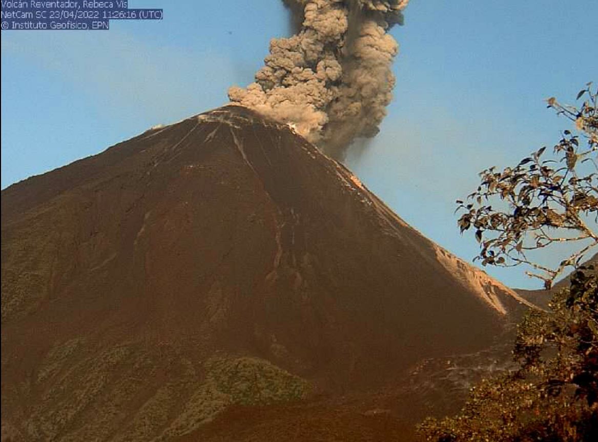
Ecuador , Reventador :
DAILY REPORT OF THE STATE OF THE REVENTADOR VOLCANO, Saturday April 23, 2022.
Information Geophysical Institute – EPN.
Surface Activity Level: High, Surface Trend: No change.
Internal activity level: Moderate, Internal trend: No change.
Seismicity: From April 22, 2022, 11:00 a.m. to April 23, 2022, 11:00 a.m.:
Explosion (EXP) 18
Long Periods (LP) 46
Emission Tremors (TREMI ) 31
Rains / Lahars:
Through the Windy system, rains were recorded in the area in the evening.
Emission / ash column:
Ash emissions greater than 600 meters above crater level were observed, with directions to the northeast, northwest and west. The Washington VAAC has reported several alerts for satellite-observed ash emissions with heights up to 988 meters above crater level with directions to the east and southeast.
Other Monitoring Parameters:
The FIRMS system records 10 thermal alerts in the last 24 hours.
Observation:
In the morning, the volcano area was clear. At the moment it is cloudy.
Gas:
Mounts satellite system reports 54 tons of SO2
Alert level: Orange.
Source : IGEPN
Photos : IGEPN .