January 21 , 2022 .
Hawaii , Kilauea :
19°25’16 » N 155°17’13 » W,
Summit Elevation 4091 ft (1247 m)
Current Volcano Alert Level: WATCH
Current Aviation Color Code: ORANGE
Activity Summary:
The summit eruption of Kīlauea Volcano, within Halemaʻumaʻu crater, continued over the past 24 hours. All recent lava activity has been confined to the crater, and there are no indications of activity migrating elsewhere on Kīlauea.
Summit Observations:
Summit tiltmeters recorded overall gradual deflation since yesterday January 19, 2022 at about 04:15 p.m. HST. Volcanic tremor associated with the eruption—as recorded by nearby seismometers— has been steady over the past 24 hours. The most recent sulfur dioxide (SO2) emission rate of approximately 2100 tonnes per day was measured yesterday January 19, 2022.
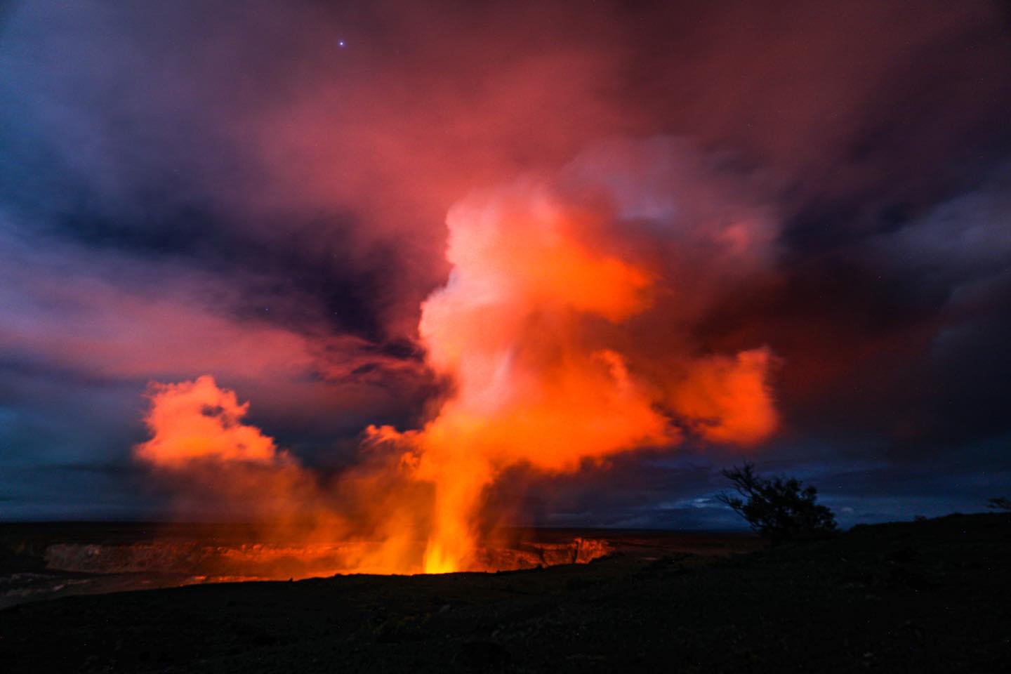
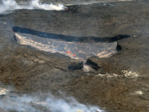
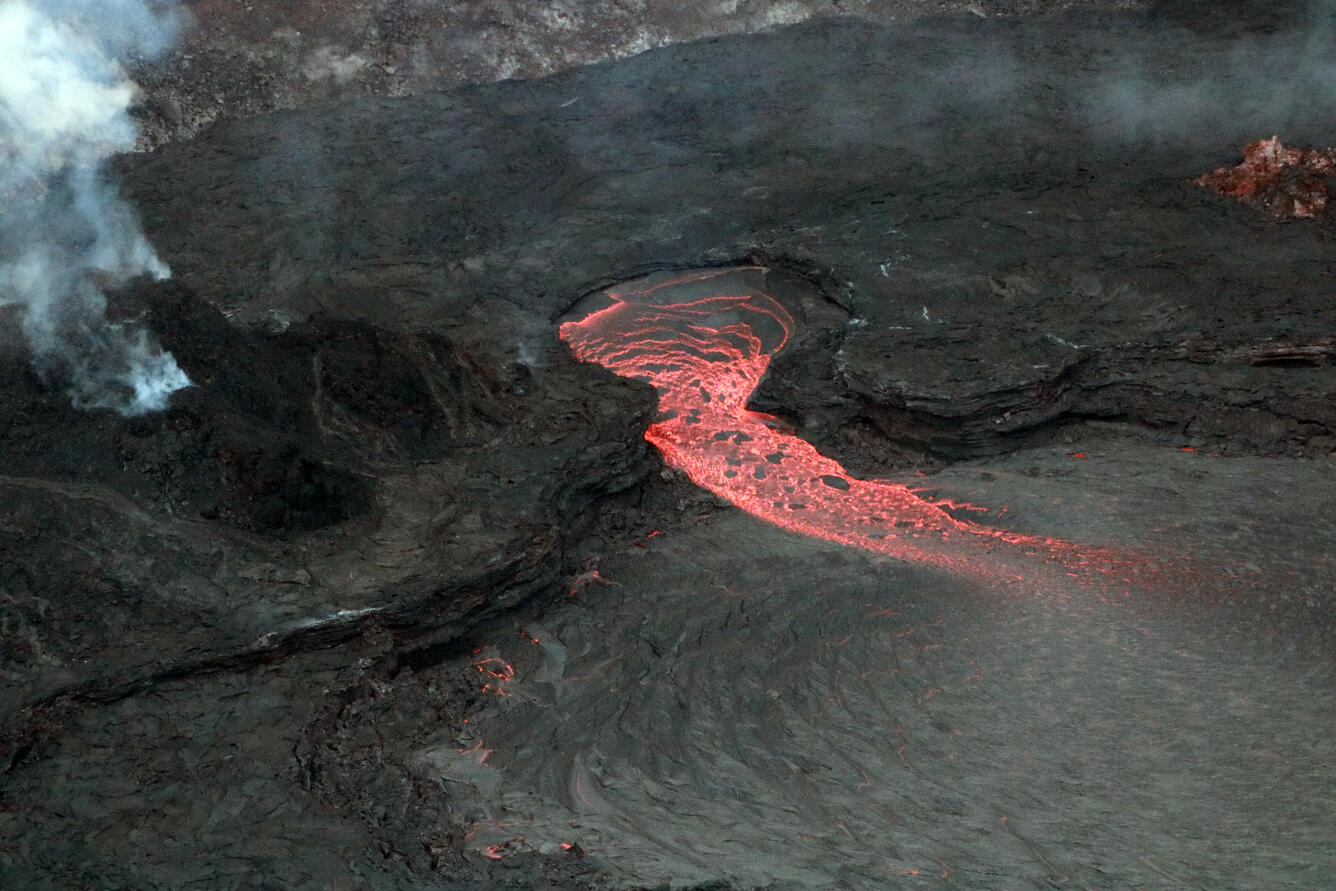
Halemaʻumaʻu Lava Lake Observations:
Lava returned to the western vent within Halemaʻumaʻu crater at about 10:45 a.m. HST on January 18 2022. The active lava lake is in the western part of Halemaʻumaʻu with occasional ooze outs along the southeastern and northwestern margins of the lava lake. The lava lake has seen a total rise of about 83 meters (272 feet) since lava emerged on September 29, 2021. Measurements on January 14, 2022 indicated that the total lava volume effused since the beginning of the eruption was approximately 45 million cubic meters (12.0 billion gallons) at that time.
Source : HVO.
Photo : USGS / K. Mulliken , Epic Lava.
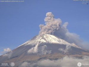
Indonesia , Semeru :
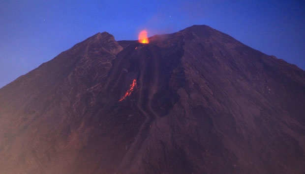
The volcano is clearly visible until it is covered by fog. The observed smoke from the crater is white / gray with moderate intensity, rising about 300 meters above the summit. The weather is sunny to rainy, the wind is light to moderate in the North, North-East and South.
At night, an incandescence is observed.
Earthquakes are related to magma and tectonic activity. We record:
– 33 earthquakes of eruptions/explosions
– 4 avalanche earthquakes
– 26 emission earthquakes
– 6 harmonic earthquakes
– 1 deep volcanic earthquake
– 1 distant tectonic earthquake
– 3 flood earthquakes (lahars).
VOLCANO OBSERVATORY NOTICE FOR AVIATION – VONA
Issued : January 21 , 2022
Volcano : Semeru (263300)
Current Aviation Colour Code : ORANGE
Previous Aviation Colour Code : orange
Source : Semeru Volcano Observatory
Notice Number : 2022SMR12
Volcano Location : S 08 deg 06 min 29 sec E 112 deg 55 min 12 sec
Area : East java, Indonesia
Summit Elevation : 11763 FT (3676 M)
Volcanic Activity Summary :
Eruption with volcanic ash cloud at 02h11 UTC (09h11 local). Eruption and ash emission is continuing.
Volcanic Cloud Height :
Best estimate of ash-cloud top is around 12403 FT (3876 M) above sea level, may be higher than what can be observed clearly. Source of height data: ground observer.
Other Volcanic Cloud Information :
Ash-cloud moving to north
Sources : PVMBG , Magma Indonésie.
Photo : Cucuk Donartono/Koz/pd/12
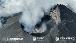
Ecuador , Sangay / Wolf :
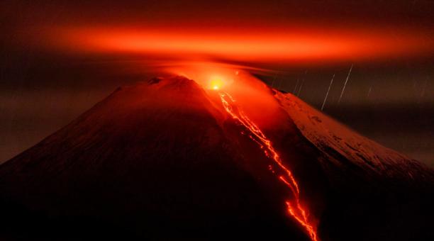
DAILY REPORT OF THE STATE OF SANGAY VOLCANO. January 20, 2022.
Surface activity level: High, Surface trend: No change.
Internal activity level: High, Internal trend: No change.
Seismicity: From January 19, 2022, 11:00 a.m. to January 20, 2022, 11:00 a.m.:
Explosions (EXP): 145
Emission Tremors (TREMI): 43
Long periods (LP): 38
Rains / Lahars:
Light rain was recorded in the volcano area. **In the event of heavy rains, these could remobilize the material accumulated in the gullies, generating mudslides and debris that would descend through the drains of the volcano and flow into the adjacent rivers.**
Emission / ash column:
No emission was observed by the cameras due to the low visibility of the volcano sector. However, the Washington VAAC reported ash emissions at 570, 1,470, and 2,070 meters above the summit in a southwest, west, and northwest direction.
Other Monitoring Parameters:
The volcano area remained cloudy most of the time. No ash fall report was received.
Alert level: yellow.
————————————————————————–
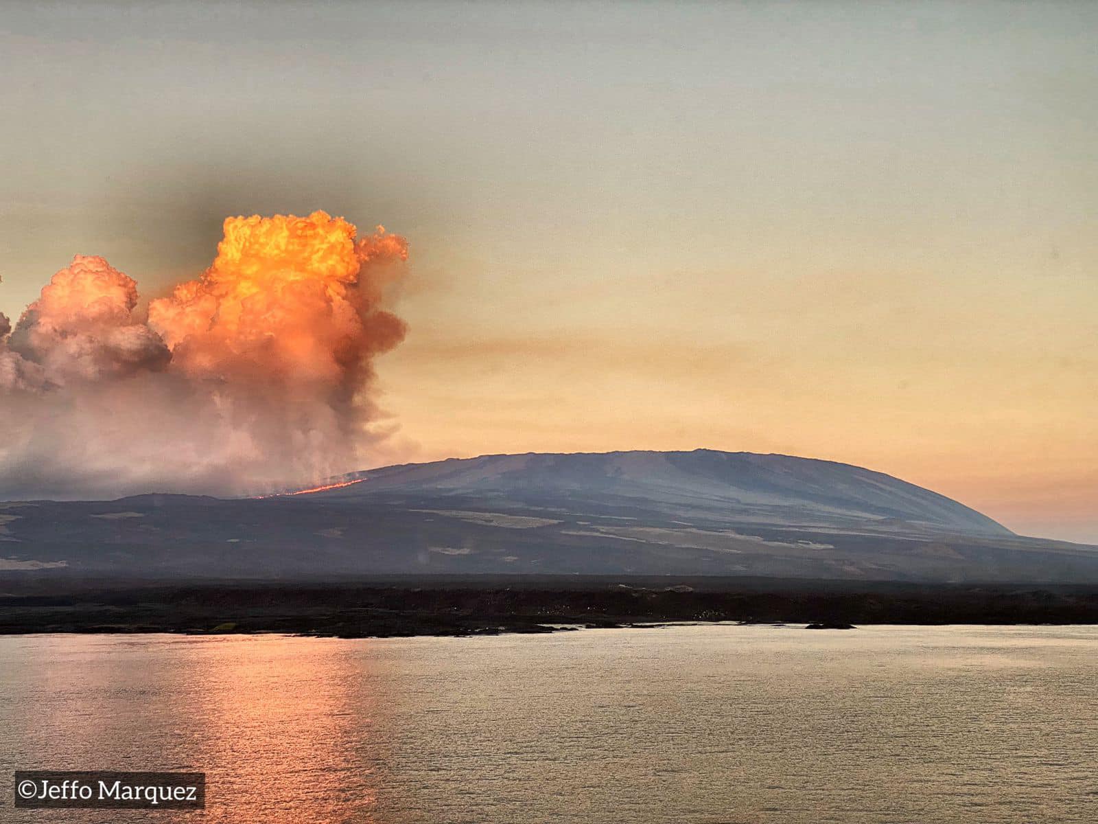
DAILY REPORT OF THE STATE OF WOLF VOLCANO. January 20, 2022.
Surface Activity Level: High, Surface Trend: Unchanged
Internal activity level: High, Internal trend: No change.
Seismicity: From January 19, 2022, 11:00 a.m. to January 20, 2022, 11:00 a.m.:
Long period type (VT): 2
Emission / ash column:
Thanks to the satellites, it was possible to observe slight gas emissions towards the South-West during the last 24 hours.
Other Monitoring Parameters:
MIROVA reports 3 extreme thermal alerts (154, 377 y 690 MW), and 1 moderate. FIRMS reports about 100 thermal alerts in the past 24 hours
Observations
Thanks to satellite images, thermal alerts continue to be observed due to the advance of lava flows
Source : IGEPN.
Photos : EFE. Jeffo Marquez .
La Palma , Cumbre Vieja :
January 18, 2022, 09:00 UTC. Post-eruption activity on Cumbre Vieja, La Palma.
In the last 7 days, since the last communication (January 11 at 9:00 UTC), 88 earthquakes have been located on the island of La Palma.
The magnitudes are between 0.6 and 2.4 (mbLg). None of these earthquakes were felt by the population.
The location of the hypocenters continues under the central area of Cumbre Vieja in the same areas as the previous days, at depths between 0 and 15 km. No earthquake was located at greater depth.

The network of permanent GNSS stations on the island does not show significant deformations that could be associated with volcanic activity.
Today the height of the cone is measured, obtaining a value of 1,120 m above sea level.
Source : IGNes
Photo : I love the world.
Colombia , Galeras :
Weekly bulletin of the activity of the Galeras volcano
The activity of the volcano continues at: YELLOW LEVEL ■ (III): CHANGES IN THE BEHAVIOR OF VOLCANIC ACTIVITY.
From monitoring the activity of VOLCANO GALERAS, the COLOMBIAN GEOLOGICAL SERVICE (SGC) reports that:
For the period evaluated between January 11 and 17, 2022, low seismic activity continued to be recorded, both in occurrence and in energy released. The dominant seismicity was related to the fracture of the rock, which was located in a dispersed way on the zone of influence of the Volcanic Complex of Galeras at distances lower than 17 km, with depths going up to 9 km compared to the level reference of 4200 m (approximately the volcanic summit) and a maximum magnitude of 1.2.

When atmospheric conditions permitted, it was possible to observe gas emissions, mainly from the fumarolic field of El Paisita (towards the northern rim of the central crater), with white, low-rise and dispersing gas columns. variable depending on the direction of the winds.
Other geophysical and geochemical monitoring parameters of the Galeras volcano did not show significant changes.
The COLOMBIAN GEOLOGICAL SERVICE remains attentive to the evolution of the volcanic phenomenon and will continue to report the changes observed in a timely manner.
Source : SGC
Photo : capra