November 16 , 2021.
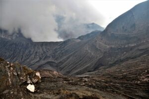
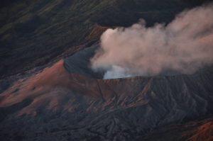
Peru , Sabancaya :
Analysis period: from November 08, 2021 to November 14, 2021, Arequipa, November 15, 2021.
Alert level: ORANGE
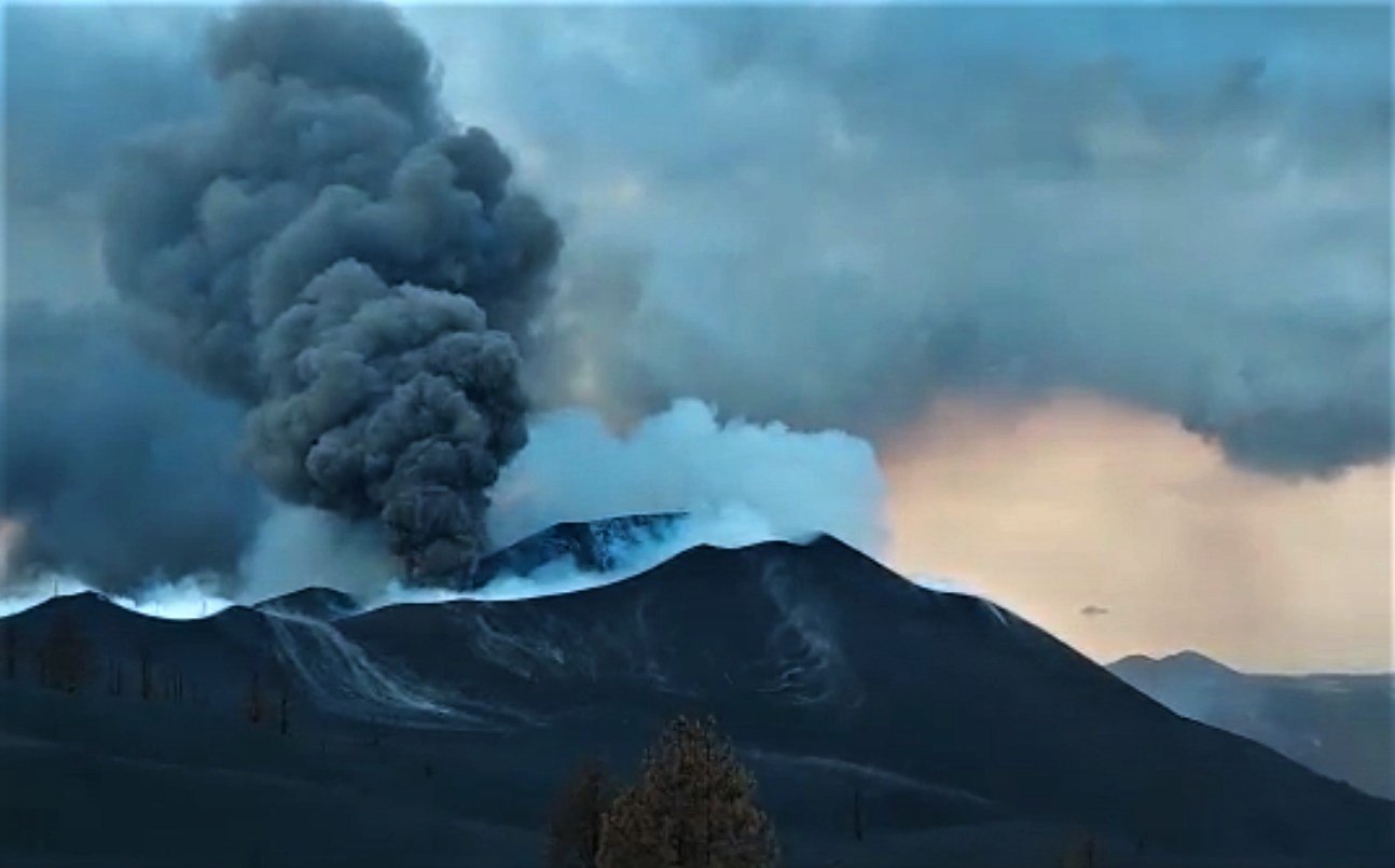
The Geophysical Institute of Peru (IGP) reports that the eruptive activity of the Sabancaya volcano remains at moderate levels, that is to say with the recording of an average of 67 daily explosions, with columns of ash and gas up to 2.5 km altitude above the summit of the volcano and their consequent dispersion. Therefore, for the following days, no significant change is expected in eruptive activity.
The IGP recorded and analyzed the occurrence of 645 earthquakes of volcanic origin, associated with the circulation of magmatic fluids within the Sabancaya volcano. An average of 67 explosions was recorded daily. During this period, Volcano-Tectonic (VT) earthquakes associated with rock fractures were located mainly in the Northwest, Northeast and North of Sabancaya and presented magnitudes between M 2.3 and M 3.4.
The monitoring of the deformation of the volcanic structure using GNSS techniques (processed with fast orbits) does not present any significant anomalies. However, in general, an inflation process was observed in the northern sector (around the Hualca Hualca volcano). The visual surveillance made it possible to identify columns of gas and ash up to 2.5 km altitude above the summit of the volcano, which were scattered towards the South-East, South-West, West and North sectors – East of Sabancaya. Satellite recordings have identified the presence of 6 thermal anomalies (maximum value of 20 MW) associated with the presence of a lava body on the surface of the volcano’s crater.
RECOMMENDATIONS
• Keep the volcanic alert level in orange.
• Do not approach within a radius of 12 km from the crater.
Source : IGP
Photo : Ingemmet.
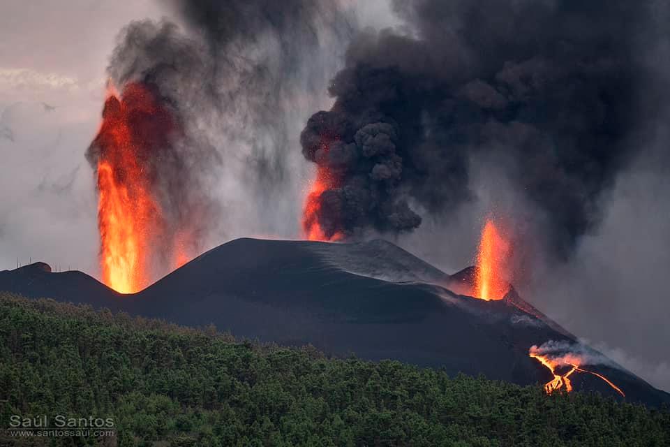
Spain / La Palma , Cumbre Vieja :
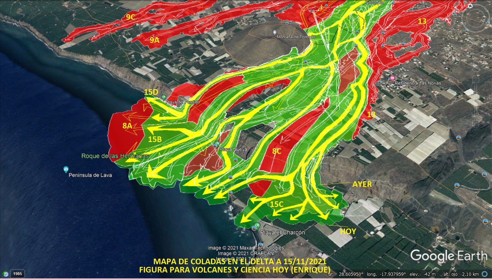
November 15, 2021, 10:00 UTC. Eruptive activity continues on La Palma.
Since the last declaration, 35 earthquakes have been located in the southern area of the island of La Palma, near the ongoing volcanic eruption, two of them were felt by the population.
The highest recorded magnitude value was 4.5 mbLg, corresponding to an earthquake that occurred at 10:20 UTC yesterday and located 37 km deep below the central area of Cumbre Vieja. This earthquake was felt with a maximum intensity IV (EMS98) in the epicentral zone.
The tremor signal continues at low values, similar to the previous days.
The island’s network of permanent GNSS stations shows that after reversing the inflation on days 4 and 5 at station LP03, which is closest to the eruptive centers, it remains at a lower level than previously established. On the other hand, the station continues to record a slight deformation towards the South
In the rest of the stations, the slight deflation possibly linked to the deep seismicity has stabilized.
In view of the calibrated image, a column height of 3,100 m is estimated. at 08:45 UTC heading North West.
As of yesterday, there has been an increase in ash emissions, which affects the Aridane Valley region.
The height of the eruptive column measured this morning is 3,100 meters.
The dispersion of ash clouds and sulfur dioxide is heading west, so this is a positive scenario for the operation of airports and is expected to continue in the next 36 or 48 hours, both on the island of La Palma and the rest of the islands airports.
Seismicity continues to be maintained at the same level at depths greater than 20 kilometers. At intermediate depths, it remains shallow compared to previous weeks. In the past 24 hours, the largest earthquake reached 4.4 to 38 kilometers and was felt with a maximum intensity of three.
Tremor remains at low levels, although it is increasing from yesterday.
The sulfur dioxide emission associated with the volcanic plume continues to be high, reaching values between 12,000 and 15,000 tonnes per day.
As for air quality yesterday it was at good or reasonably good levels in all seasons except in the Aridane Valley and Puntagorda, where it is now consistent.
Particles smaller than ten microns are concentrated at very high levels, placing air quality at unfavorable levels. In the region of Llanos de Aridane, El Paso, Tazacorte, Tijarafe and Puntagorda, the population must reduce their activities outside.
Technicians from the Canary Islands Volcanological Institute (Involcan) have detected that eruption activity has « increased significantly » in recent hours, as the institution shared on its Twitter account. « There is a huge column of ash and gas that started shortly after noon yesterday, which brings the activity of the volcano closer to level 3 of the explosive activity index (VEI) », explains one of the scientists. of Involcan. This index corresponds to a scale ranging from 0, non-explosive eruptions, to 8, the maximum attributed to the largest eruptions identified in the geological records.
Rubén López, volcanologist of the National Geographical Institute, confirmed this Monday to EL PAÍS that a new flow has reached the sea. It is therefore the third lava flow from the volcano Cumbre Vieja, in La Palma, which reaches the ocean after another tongue of magma hit the coast in the Guirres beach area last week. The front which has reached the sea is further south than the previous ones.
Sources : IGN es , El Pais .
Photos : Saul Santos ,
Carte : Volcanes y Ciencia Hoy
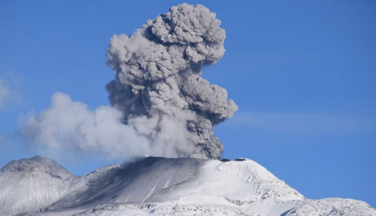
Indonesia , Ibu :
VOLCANO OBSERVATORY NOTICE FOR AVIATION – VONA
Issued : November 16 , 2021
Volcano : Ibu (268030)
Current Aviation Colour Code : ORANGE
Previous Aviation Colour Code : orange
Source : Ibu Volcano Observatory
Notice Number : 2021IBU24
Volcano Location : N 01 deg 29 min 17 sec E 127 deg 37 min 48 sec
Area : North Maluku, Indonesia
Summit Elevation : 4240 FT (1325 M)
Volcanic Activity Summary :
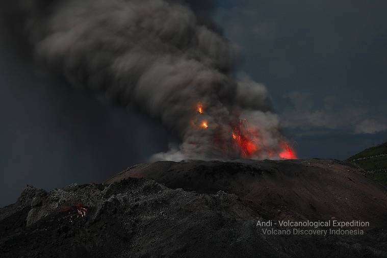
Eruption with volcanic ash cloud at 00h05 UTC (09h05 local).
Volcanic Cloud Height :
Best estimate of ash-cloud top is around 6800 FT (2125 M) above sea level, may be higher than what can be observed clearly. Source of height data: ground observer.
Other Volcanic Cloud Information :
Ash-cloud moving to north.
Remarks :
Eruption and ash emission is continuing
Level of activity Level II (WASPADA). G. Ibu (1340 m altitude) has been in continuous eruption since 2008.
The volcano is clearly visible until it is covered in fog. The smoke from the crater is thick white with low to medium intensity, about 200-800 meters high from the summit. The weather is sunny, cloudy to rainy, the winds are weak to moderate in the south.
According to the seismographs of November 7, 2021, it was recorded:
81 eruption / explosion earthquakes
73 avalanche earthquakes
46 emissions earthquakes
21 harmonic tremors
Sources : Magma Indonésie , PVMBG.
Photo :Andi Rosati / Volcanodiscovery.
Chile , Laguna del Maule :
– 216 earthquakes classified as volcano-tectonic (VT) type have been recorded, associated with fracture processes of rigid materials in volcanic systems. The most energetic earthquake had a local magnitude (ML) of 2.1 and was located 3.7 km east-south-east of the lagoon center, with a depth of 4.6 km.
– Likewise, a seismic activity of the Long Period (LP) type was recorded, signals associated with the dynamics of the fluids inside the volcanic conduits. Among these, 3 earthquakes were classified, the sizes of which, valued from the Reduced Displacement (DR) parameter, reached a maximum value equal to 4.4 cm2.

– The images provided by the fixed camera installed near the complex did not record any surface activity associated with the volcanic system.
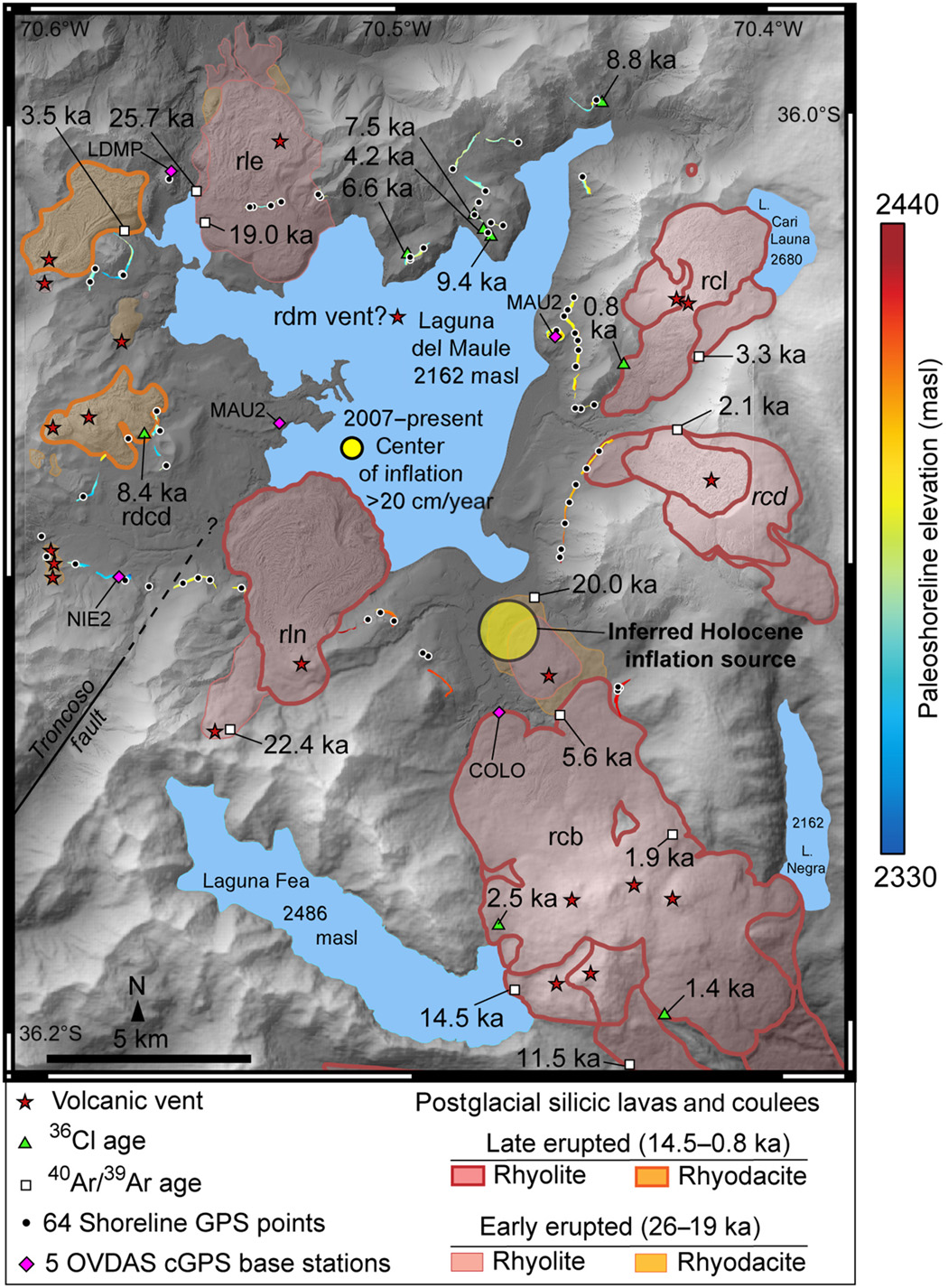
– According to data obtained from the geodetic monitoring network installed in the complex (5 GNSS stations and 4 electronic inclinometers), it was observed that the inflationary process monitored since 2012 continues, with rates of increase equivalent to the average recorded during the last 2 years. For 30 days, the maximum uplift has continued to be recorded in the MAU2 GNSS station, in the southwest sector of the lagoon, with a rate of 2.3 ± 0.2 cm / month. The data obtained with the EI show variations without relevant trends.
– The processing of satellite images (Sentinel 2 – L2 A, Planet Scope) makes it possible to confirm an absence linked to morphological changes and thermal anomalies.
– No anomalies were reported in sulfur dioxide (SO2) emissions into the atmosphere in the area near the volcanic complex, according to data published by the Tropospheric Monitoring Instrument (TROPOMI) and the Ozone Monitoring Instrument (OMI) ) Sulfur Dioxide Group.
– During the period, no thermal alert was recorded in the area associated with the volcanic complex, according to data processed by the near real-time thermal monitoring of global hot spots (MODVOLC).
As described, the monitoring parameters indicate persistent, albeit less, activity above the baseline. The level of technical alert is maintained in Amarilla.
YELLOW TECHNICAL ALERT: Changes in the behavior of volcanic activity.
Observation:
The affected area is considered to be that contained within a radius of 2000m around the passive CO2 degassing center, detected in 2019, 2020 and 2021.
Source : Sernageomin.
Photo : Dr Katie Keranen.
Carte : http://www.science.org/doi/10.1126/sciadv.aat1513
Guatemala , Santiaguito :
Geographical location: 14 ° 44’33 ‘Latitude N; 91 ° 34’13˝ Longitude W.
Height: 2,500 m
Weather conditions Clear
Wind: North 4 km / h
Precipitation: 0.0 mm

Activity:
The observatory of the Santiaguito volcano OVSAN reports a white degassing above the crater which is dispersed in a westerly direction. Weak to moderate explosions were recorded which expel white and gray columns at a height of 3,400 meters above sea level (11,155 feet) which are scattered in a westerly and southwest direction. Weak, moderate and some heavy boulder and ash avalanches continue to be generated on the western, southwest, south and southeast flanks, some reaching the base of Dome Caliente. A slight degassing noise similar to that of an airplane turbine can be heard due to the pressure of the magmatic gases. Due to the blocky lava extrusion from Dome Caliente in a West-South-West direction and unstable material in the crater, there is a likelihood of moderate to heavy pyroclastic flows, so do not stay near or close to it. inside the channels of the rivers near the slopes of the volcano.
Source : Insivumeh.
Photo : Annie Winson , earthobservatory.sg