April 12 , 2021.
La Réunion , Piton de la Fournaise :
Press release of 04/11/2021 – 3.30 p.m.
The eruption that began on 04/09/2021 at 7 p.m. (appearance of the tremor) continues (Figure 1). The intensity of the volcanic tremor (indicator of the intensity of the eruption), after a relatively stable phase on the day of 04/10/2021, has been declining gradually since 9 a.m. (local time, 5 a.m. UT time) today.
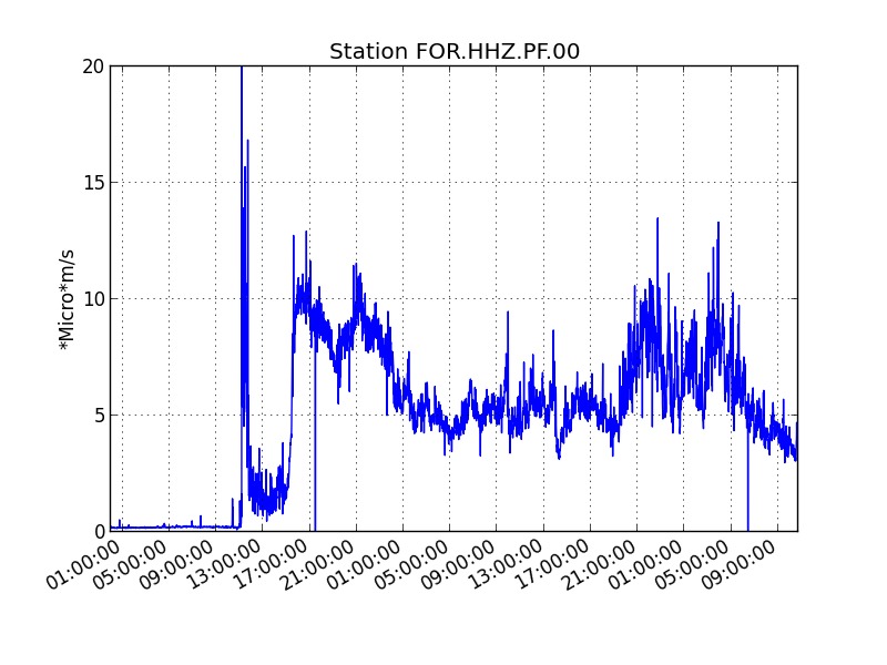
Figure 1: Evolution of the RSAM (indicator of the volcanic tremor and the intensity of the eruption) since 04/09/2021 on the FOR seismological station located at the level of the Château Fort crater (© OVPF / IPGP).
Over the last 24 hours, 32 superficial volcano-tectonic earthquakes (between sea level and the surface) have been recorded under the summit craters.
An observatory mission this morning made it possible to fly over and sample the eruptive site.
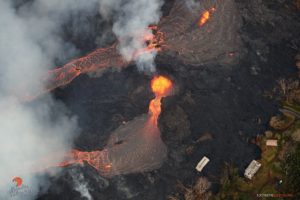
Shot of the eruptive site on 04/11/2021 8:50 a.m. local time (© OVPF-IPGP).
This morning activity focused on a primary eruptive mouth and a smaller secondary eruptive mouth downstream (Figure 2). A cone is being built around these two mouths from which fountains of lava flow intermittently, varying their height between 30 and 60 meters.
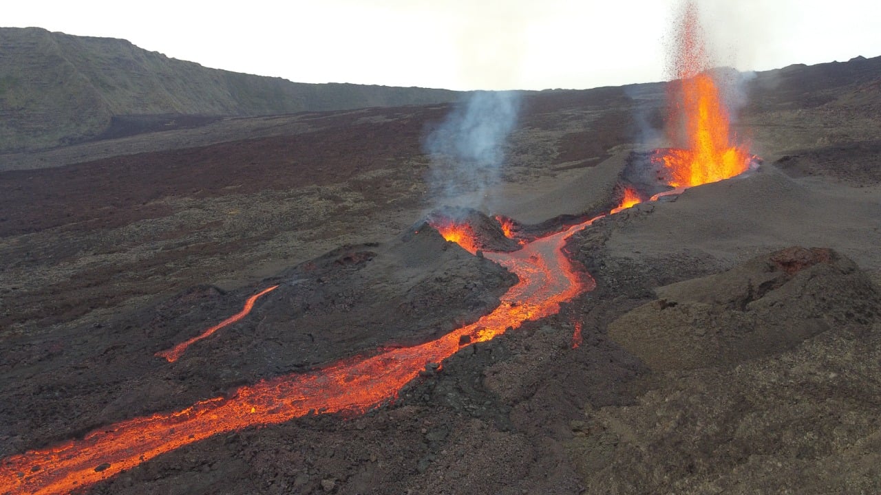
Figure 2: Shot of the eruptive site on 04/11/2021 8:50 a.m. local time (© OVPF-IPGP).
The activity of the vent fed a single flow, the front of which was located this morning (7am) about 700 m from the Grandes Pentes broken at around 1750 m altitude.
The surface flows estimated from satellite data via the HOTVOLC platform (OPGC – University of Auvergne), show flows for the morning of 04/11/2021 of the order of 8 m3 / s. This estimate may however be underestimated given the cloud cover on the eruptive site.
Alert level: Alert 2-2.
Press release of 04/12/2021 – 6:30 a.m.
The eruption that began on 04/09/2021 at 7 p.m. (appearance of the tremor) continues (Figure 1). The intensity of the volcanic tremor (indicator of the intensity of the eruption), despite some fluctuations, remains relatively stable.
Over the last 24 hours, 93 superficial volcano-tectonic earthquakes (between sea level and surface) have been recorded under the summit craters.
InSAR satellite data shows that the deformations, in the order of decimeter, linked to the injection of magma towards the eruptive site have remained confined inside the Enclos Fouqué caldera.
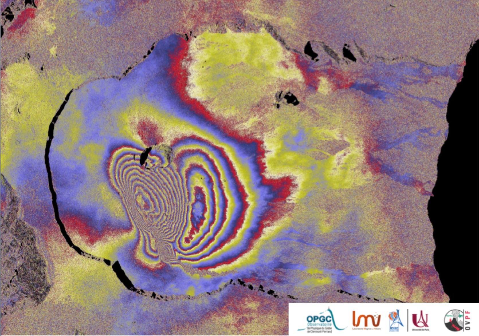
Interferogram representing the deformations at Piton de la Fournaise associated with the eruption of April 9, 2021 (© LMV-OPGC). In addition to ground measurements, the OVPF also uses a satellite technique called dInSAR to monitor edifice inflation / deflation cycles associated with magma movements at depth. To do this, the satellite “illuminates” an area of the ground with an electromagnetic wave and collects the signal reflected from the ground. Comparing two measurements of this type of the same surface taken at different times makes it possible to image the deformations of the surface. The above interferogram shows the deformation of the surface associated with the eruption of April 9, 2021. Each complete color cycle (from red to blue) of the interferogram corresponds to 27.8 mm of surface displacement towards (positive) or the opposite (negative) of the Sentinel-1 satellite (whose direction is represented by the arrow “LOS” at the top right of the figure). (© LMV-OPGC-OVPF-IPGP)
These data are in good agreement with the data recorded on the permanent GPS stations of the OVPF-IPGP which recorded up to forty cm of deformation in the
Château Fort crater.
Satellite data also made it possible to trace the precise outline of the lava flow. Yesterday evening (around 7 p.m. local time), the flow had traveled since the start of the eruption about 3.2 km and the flow front was located at the level of the Grandes Pentes broken (around 1690 m above sea level), like this was visible on the OVPF-IPGP webcam located in Piton des Cascades.
The NOVAC data from the OVPF-IPGP stations since April 9 indicates a moderate SO2 emission rate of between 2 and 4 ktons / day at most. With regard to the composition of
emissions at Piton de la Fournaise, this is equivalent to a surface flow of the order of 10-25 m3 / s.
These surface flows are in agreement with the flows estimated from satellite data via the HOTVOLC platform (OPGC – Clermont Auvergne University), which show flows since the start of the eruption between 8 and 30 m3 / s. These fluctuations are partly due to cloud cover at the eruptive site which disturbs these estimates.
Alert level: Alert 2-2
Source : OVPF.
Lire l’article : https://www.ipgp.fr/sites/default/files/ovpf_20210411_15h30_communique_eruption.pdf
Photos : OVPF
Saint Vincent , Soufrière Saint Vincent :
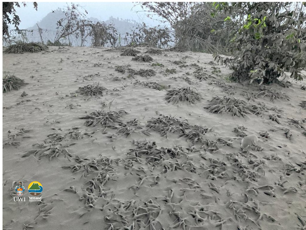
La Soufriere Eruption Scientific Update 11/04/21 9am
– Thunder and lightning were experienced during these periods.
– Heavy ash fall was observed at the Belmont Observatory throughout the night.
– Ashfall was also reported to have occurred in most areas of the island overnight and in neighbouring islands: the Grenadines, Barbados and Saint Lucia.
– Explosions and accompanying ashfall, of similar or larger magnitude, are likely to continue to occur over the next few days.
Source et photo : UWI
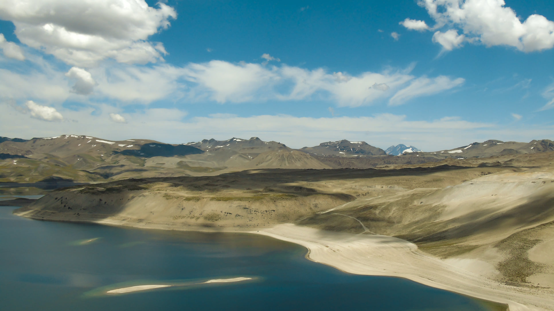
Chile , Laguna del Maule :
For the period evaluated, the seismic activity associated only with rock fracturing (VT) showed a decrease in energy and the number of events compared to the previous fortnight.
The event with the highest energy recorded had a local magnitude (ML) of 1.6 and was located 5.5 km west-southwest (WSW) of the center of the lagoon with a depth of 5.0 km.
During this period, events associated with fluid dynamics (LP types and a tremor pulse) as well as activity associated with mixed processes, rock breaking and fluid circulation (HB type) have occurred. been registered.
The hybrid events (HB) with the highest energy were located 12.3 km and 12.4 km south-southeast of the center of the lagoon with depths of 7.4 km and 7.6 km respectively , both with a local magnitude (ML) of 2.4.
Data from GNSS stations showed that the deformation process continues with higher heave rates than the average recorded since 2012. The highest heave rate of the last 30 days is 2.6 cm / month in the station closest to the deformation center. . Horizontal displacements showed a maximum rate of 0.9 cm / month. The data analyzed with remote sensors shows consistency with the information provided by the GNSS network plus some additional signals possibly associated with local processes in response to the main inflationary process.
Surveillance camera images did not report surface activity associated with the volcanic complex.
Source : Segemar.
Photo : Franco Vera.
Russia / Kurile Islands , Ebeko :
VOLCANO OBSERVATORY NOTICE FOR AVIATION (VONA).
Issued: April 12 , 20210412/0228Z
Volcano: Ebeko (CAVW #290380)
Current aviation colour code: ORANGE
Previous aviation colour code: orange
Source: KVERT
Notice Number: 2021-51
Volcano Location: N 50 deg 41 min E 156 deg 0 min
Area: Northern Kuriles, Russia
Summit Elevation: 1156 m (3791.68 ft)
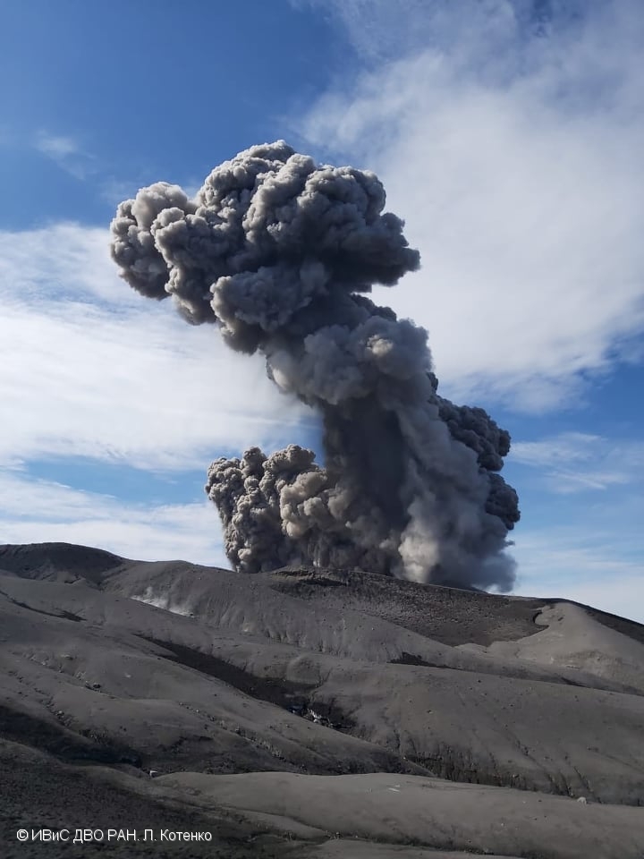
Volcanic Activity Summary:
A moderate eruptive activity of the volcano continues. According to visual data by volcanologists from Severo-Kurilsk, explosion sent ash up to 2 km a.s.l., an ash cloud is drifting to the east of the volcano.
A moderate eruptive activity of the volcano continues. Ash explosions up to 6 km (19,700 ft) a.s.l. could occur at any time. Ongoing activity could affect low-flying aircraft and airport of Severo-Kurilsk.
Volcanic cloud height:
2000 m (6560 ft) AMSL Time and method of ash plume/cloud height determination: 20210412/0224Z – Visual data
Other volcanic cloud information:
Distance of ash plume/cloud of the volcano: 5 km (3 mi)
Direction of drift of ash plume/cloud of the volcano: E
Time and method of ash plume/cloud determination: 20210412/0224Z – Visual data
Source : Kvert.
Photo : L. Kotenko. IVS FEB RAS