April 10, 2021.
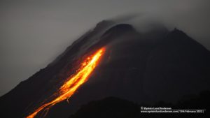
Saint Vincent , Soufrière Saint Vincent :
LA SOUFRIÈRE VOLCANO , ACTIVITY BULLETIN, APRIL 09, 2021, 9:00 a.m.
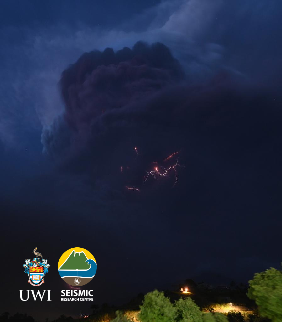
1. Scientists at the Belmont Observatory confirmed that there was an explosive eruption at the La
Soufriere Volcano at 8.40 this morning.
2. Ash plumes of up to 8 km were observed.
3. Ash fall has been recorded at the Argyle International Airport
4. All persons in the red volcano hazard zone are asked to evacuate immediately.
As of 8:41 am this morning April 9, 2021 an explosive eruption began at the La Soufrière volcano in St. Vincent. This is a culmination of the seismic activity that began on April 8. The eruption is ongoing and more information will be shared as things progress.
La Soufriere Eruption Scientific Update – April 9, 2021 8pm
– Vigorous ash venting resumed at La Soufriere at approximately 2:45 pm.
– Lightning can now be seen in the ash column due to its highly charged nature.
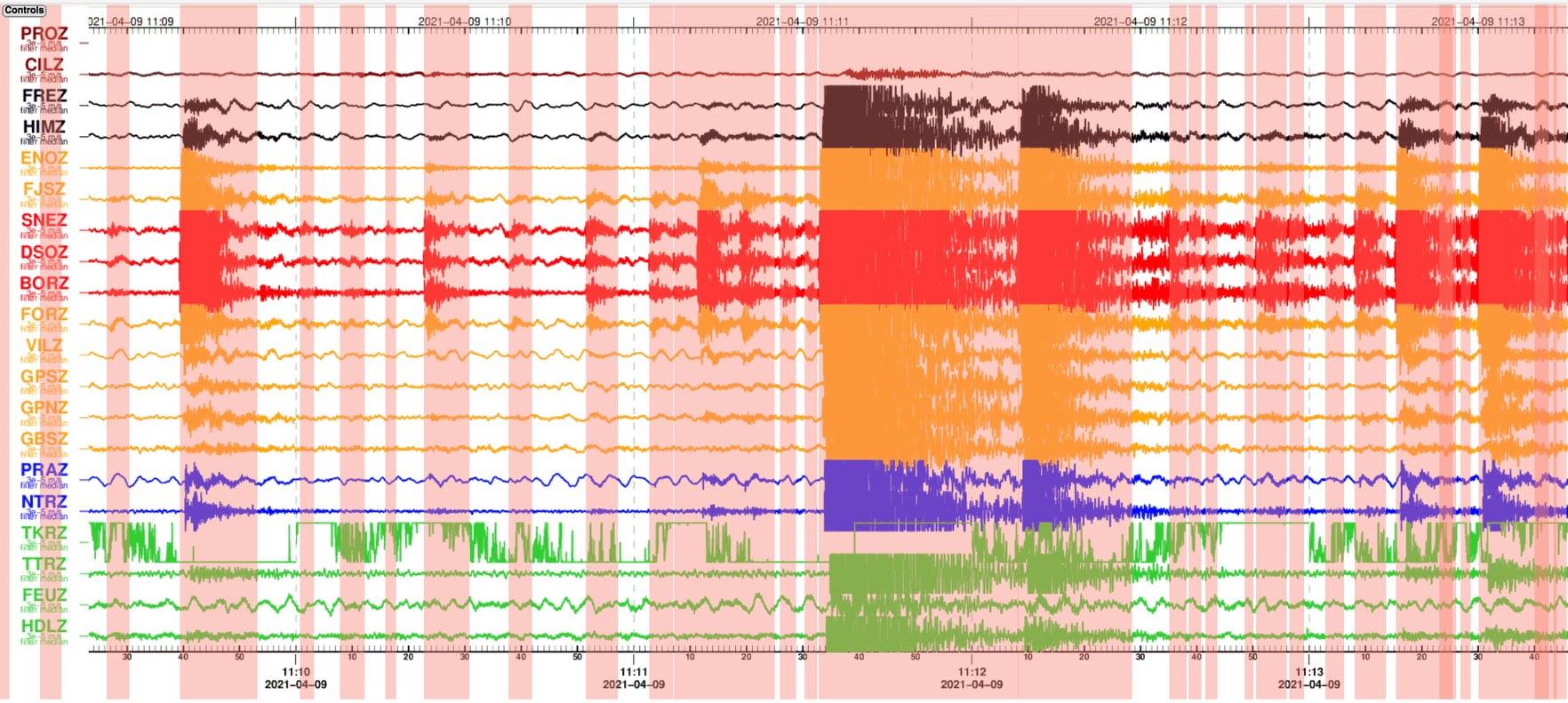
– After the initial explosion, seismicity increased again at approximately 11:30am with a swarm of earthquakes lasting until 2:40pm.
– Continuous tremor has been recorded since 3pm with the largest signals accompanying the most vigorous venting.
– The volcano continues to be in an explosive phase that may last several days to weeks.
Source : Nemo .
Photos : UWL
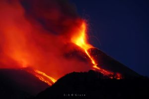
La Réunion , Piton de la Fournaise :
OVPF press release of 04/09/2021 – 3:20 p.m.
Since 2:57 p.m. local time (10:57 a.m. UTC), a seismic crisis has been recorded on the instruments of the Piton de la Fournaise Volcanological Observatory. This seismic crisis is accompanied by rapid deformation. This indicates that the magma is leaving the magma reservoir and is spreading towards the surface.
A rash is likely shortly within the next few minutes or hours.
Additional information will follow concerning the sector impacted by this magmatic propagation towards the surface.
Following the seismic crisis which began at 2:57 p.m. local time, the volcanic tremor synonymous with the arrival of magma near the surface has been recorded since 7:00 p.m. local time. According to OVPF records, the source of this tremor is located on the southern flank of the volcano inside the Enclosure.
Alert level: Alert 2-2.
Press release 04/09/2021 – 6:10 p.m.
The seismic crisis that began at 2:57 p.m. local time (10:57 a.m. UTC) at Piton de la Fournaise continues. This seismic crisis is accompanied by rapid deformation. This indicates that the magma
is leaving the magmatic reservoir and spreading towards the surface. Between 2:47 p.m. and 5:45 p.m. (local time), more than 700 superficial volcano-tectonic earthquakes were recorded by the Piton de la Fournaise Volcanological Observatory. The source of the deformation and the seismicity show a propagation of magma under the southern flank, with events located less than 1 km from the rampart of the Enclos Fouqué.
The activity is currently focused on two main eruptive mouths. The upstream part of the crack is no longer active (© OVPF-IPGP).
Press release 04/09/2021 – 7:25 p.m.
Following the seismic crisis which began at 2:57 p.m. local time, the volcanic tremor synonymous with the arrival of magma near the surface has been recorded since 7:00 p.m. local time. According to the
OVPF records, the source of this tremor is located on the southern flank of the volcano inside the Enclosure.
No visual confirmation of the start of an eruption could be made on webcams yet due to bad weather conditions and we cannot confirm the arrival of lava on the surface. However, the presence of a tremor shows the emission of hot and incandescent gases on the surface, and the possibility of lava emission in the very short term.
Press release of 04/10/2021 – 10:00 a.m.
The eruption that started on 04/09/2021 at 7 p.m. (appearance of the tremor) continues. The intensity of the volcanic tremor (indicator of the intensity of the eruption), after an increasing phase at the start of the eruption, has been declining gradually since 9 p.m. (local time, 5 p.m. UT).
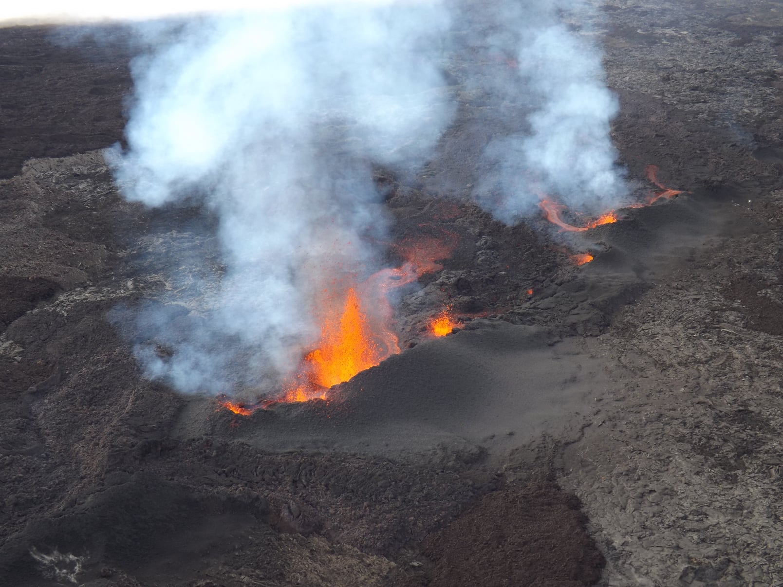
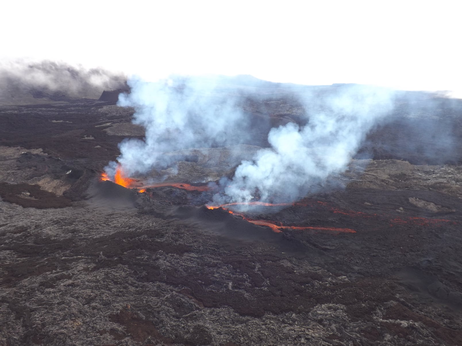
Following an overview of the eruptive site carried out this morning with the assistance of the SAG and the PGHM, the eruptive fissure could be located with precision, 700 m southwest of the Château Fort crater.
During the flyby, around 8:40 a.m. local time, activity focused on two main eruptive vents in which several regimes of lava fountains were observed. The upstream part of the crack is no longer active. The lava fountains did not exceed thirty meters in height.
The flow had traveled about a mile to the east and the flow front, consisting of aa lava, was spreading very slowly. It was this morning at 8:40 am around 1800 m altitude.
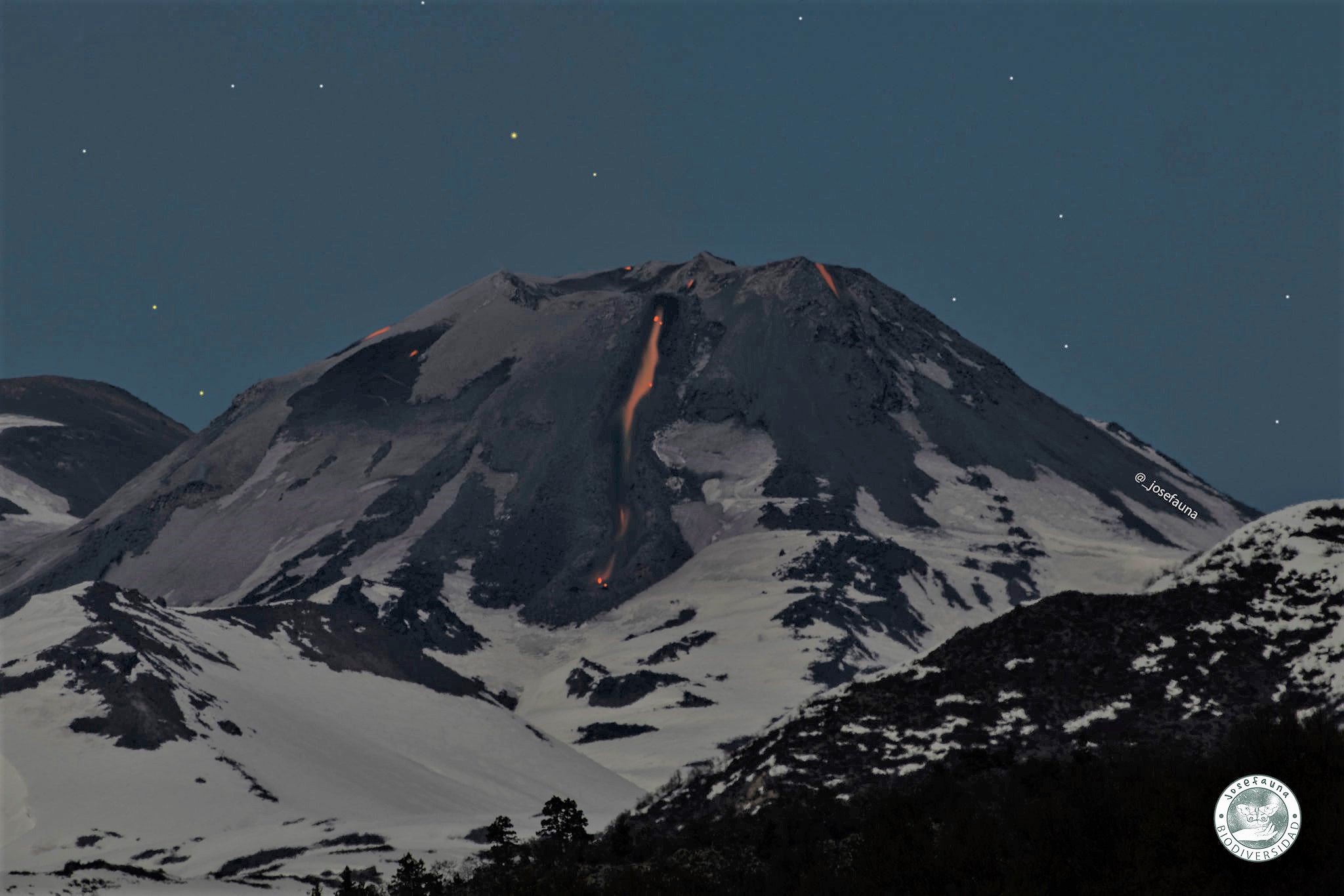
Chile , Nevados of Chillan :
The seismicity parameters associated with the fracturing processes of rigid materials (VT types) and fluid dynamics (LP, TR and EX types) showed a stable trend compared to the previous period, both due to their energy and the number of events.
The highest energy VT-type event, with a local magnitude (ML) of 3.2, was located 3.5 km east-southeast (ESE) of the active crater and at a 3.9 km deep.
The analysis of the images provided by the surveillance cameras belonging to the OVDAS as well as those obtained during an overflight demonstrated the continuity of the effusive and explosive dynamics during this fortnight. The effusive activity maintains the growth of the dome which records explosions and the emission of fragments at a distance of 138 m from the crater. The advance of the lava flow, at a speed of 0.1 m / h and with an estimated range of 945 m, continues to show greater development of its central channel and front. Explosive activity exhibited maximum column heights of 1060 m, with varying particulate matter content.
A volume for the dome of 305,850 m³ and a volume of 1,725,484 m³ is estimated, calculated from digital elevation models.
When weather conditions permitted, it was possible to record the nocturnal incandescence associated with the dome on a recurring basis and focused on the crater area.
According to data obtained from the network of GNSS stations and inclinometers installed on the volcano, the inflationary trend continues to be observed with a slight decrease in the rate of uplift at all stations.
Eleven (11) thermal alerts were recorded in the area with a maximum value of 8 MW, considered moderate for this volcano. Radiation anomalies were detected on March 16, 19, 24, 26, 29 and 31 from Sentinel 2-L2A image analysis.
There was no increase in the mean temperature observed for the lava flow during this period.
Source : Segemar .
Photo : Josefauna.
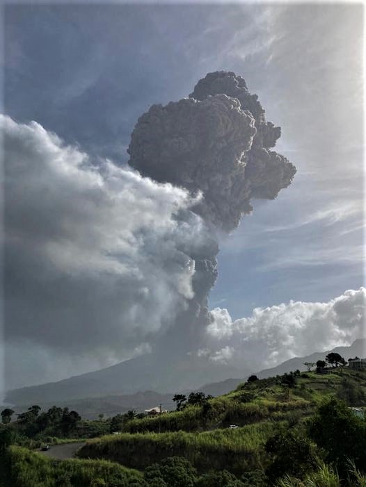
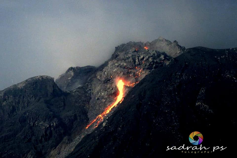
Indonesia , Sinabung :
The activity level has been at level III (SIAGA) since May 20, 2019 at 10:00 a.m. WIB. Mount Api Sinabung (2460 m above sea level) has been erupting since 2013. The last eruption occurred on April 8, 2021 with a maximum column height of 700 meters above the summit.
The volcano was clearly visible until it was covered in fog. The smoke from the crater is observed to be white with moderate to strong intensity, about 50-200 meters above the summit. The weather is sunny to cloudy, with light to moderate winds from the east, south-east, south-west, west and north-west. There was an eruption / explosion, but visually the height of the eruption and the color of the ash was not observed. Avalanches were observed with a sliding distance of 500 to 1000 m to the east and south-east
According to the seismographs of April 9, 2021, it was recorded:
1 eruption earthquake.
64 avalanche earthquakes
1 emission earthquake
16 low frequency earthquakes
93 hybrid / multi-phase earthquakes
2 deep volcanic earthquakes
4 distant tectonic earthquakes.
VOLCANO OBSERVATORY NOTICE FOR AVIATION – VONA.
Issued : April 10 , 2021
Volcano : Sinabung (261080)
Current Aviation Colour Code : ORANGE
Previous Aviation Colour Code : orange
Source : Sinabung Volcano Observatory
Notice Number : 2021SIN35
Volcano Location : N 03 deg 10 min 12 sec E 98 deg 23 min 31 sec
Area : North Sumatra, Indonesia
Summit Elevation : 7872 FT (2460 M)
Volcanic Activity Summary :
Eruption with volcanic ash cloud at 01h16UTC (08h16 local)
Volcanic Cloud Height :
Best estimate of ash-cloud top is around 9472 FT (2960 M) above sea level, may be higher than what can be observed clearly. Source of height data: ground observer.
Other Volcanic Cloud Information :
Ash-cloud moving to W – NW
Remarks :
Seismic activity is characterized by eruption
Source : PVMBG, Magma Indonésie .
Photo : Sadrah PS.