April 09 , 2021 .
Saint Vincent , Soufrière Saint Vincent :
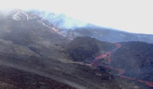
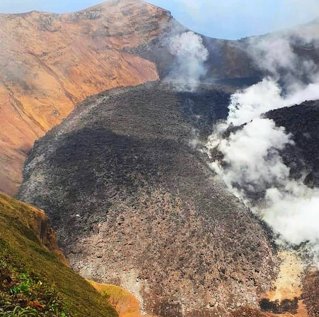
La Soufriere volcano raised to alert level Red . St. Augustine, Trinidad and Tobago, W.I. – 6:30pm April 8th, 2021
– Scientists have observed a significant increase in activity at La Soufriere volcano which has prompted The Government of Saint Vincent and the Grenadines to raise the volcanic alert level at the La Soufriere volcano to Red.
The UWI-Seismic Research Centre scientific team based at the Belmont Observatory in St. Vincent recorded six separate bands of volcanic tremor throughout the day. This new type of seismic event has not yet been observed since the beginning of the eruption in December 2020. This type of seismic signal is usually associated with movement of magma and fluids close to the surface. Ash venting was also observed during the most recent tremor episode.
The effusive eruption is continuing and an explosive phase of the eruption may begin with very little warning.
An evacuation order has been issued for communities in the Red volcanic hazard zone. Prime Minister Ralph Gonsalves made the announcement during the second of two press conferences held in Kingstown today. The UWI-SRC Geologist and Scientific Team Lead, Prof. Richard Robertson indicated that “We cannot give any clear warning that nothing can happen within the next 24-48 hours and we would not be surprised if there are explosions at the volcano during that period.”
At alert level Red the public is advised to urgently comply with directives issued by NEMO. NEMO has advised that safe areas are those from North Union to Kingstown, on the Windward side of the island, Barouallie to Kingstown on the Leeward side and the Grenadine Islands.
Seismic activity at La Soufrière, St Vincent changed significantly today when the seismic station closest to the summit began recording low-level seismic tremors on April 8.
2. Six separate episodes, or bands, of tremors starting at 3 am were recorded with intervals of about two and a half hours between them. The tremor episodes have slowly increased in magnitude.
3. A tremor is a continuous seismic signal that is usually associated with the movement of magma to the surface.
4. The seismic network also recorded five long-period earthquakes during the second and fourth bands of tremor. Long-period earthquakes are also usually associated with the movement of magma.
5. There were also two brief swarms of small volcano-tectonic (VT) earthquakes, both taking place between bands of tremor. These were located at depths up to 5 kilometres below the summit of La Soufrière, which is consistent with the depths of the two VT swarms on 23-26 March and on April 5.
6. Elevated and continuous periods of gas venting from the summit of the volcano, coinciding with the bands of tremor were observed. At times there was a well-defined plume.
7. Visual observations made from the Observatory at Belmont during the early evening indicate that the dome height increased significantly during the day. The glow from the dome was visible from Belmont.
8. The volcano has entered a heightened period of activity indicative of a fresh batch of magma either near to, or approaching the surface. The possibility for activity to move to an explosive phase has increased significantly. Given the current data it’s not possible to say exactly what the time scale would be.
Source : UWI.
Photo : UWI
Hawaii , Kilauea :
19°25’16 » N 155°17’13 » W,
Summit Elevation 4091 ft (1247 m)
Current Volcano Alert Level: WATCH
Current Aviation Color Code: ORANGE
Activity Summary:
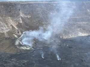
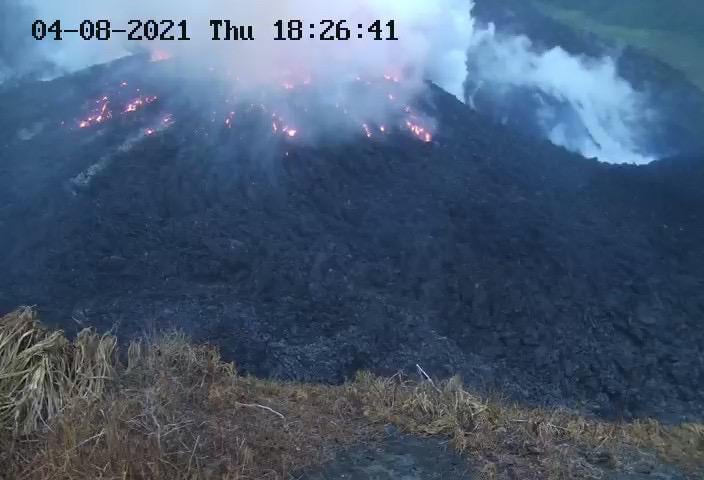
Kīlauea Volcano is erupting. Lava activity is confined to Halemaʻumaʻu with lava erupting from a vent on the northwest side of the crater. This morning, April 7, the lava lake was 225 m (738 ft) deep and remains stagnant over its eastern half. SO2 emission rates remain elevated at 850 t/day, last measured on April 5.
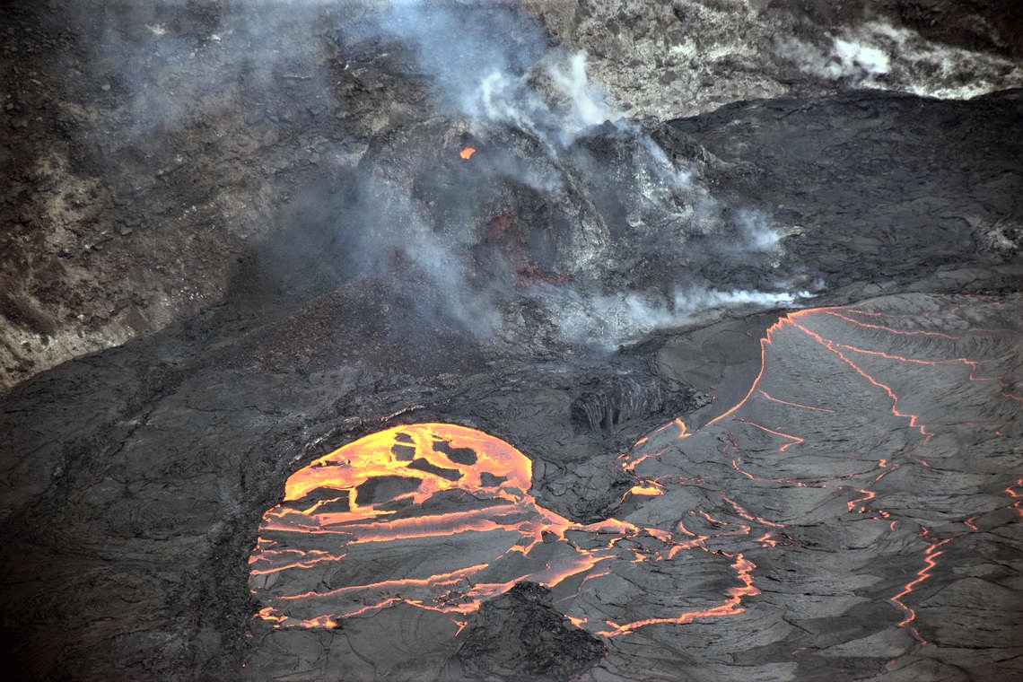
A telephoto image from the ongoing eruption within Halema‘uma‘u crater at the summit of Kīlauea. Lava continues to enter the lava lake through an inlet near the base of the west vent cone (right). An incandescent opening near the top of the cone (upper center), ejected occasional bursts of spatter. Crustal foundering of a section of the lava lake surface crust (lower center) is common. This photo was taken from the southern crater rim, in an area of Hawai‘i Volcanoes National Park which remains closed to the public due to safety reasons.
Summit Observations:
The most recent sulfur dioxide emission rate, measured on April 5, was 850 t/day. This is elevated compared to rates in the months before the eruption started on December 20 (less than 100 t/day), but lower than emission rates from the pre-2018 lava lake (around 5,000 t/day). Summit tiltmeters recorded minor change over the past 24 hours. Seismicity remains stable, with elevated tremor.
East Rift Zone Observations:
No unusual activity noted in the region. Geodetic monitors indicate that the summit and upper East Rift Zone—between the summit and Puʻu ʻŌʻō—is refilling at rates similar to those measured over the past 2 years and before the December 2020 eruption. SO2 and H2S emissions from Puʻu ʻŌʻō were below instrumental detection levels when last measured on January 7.
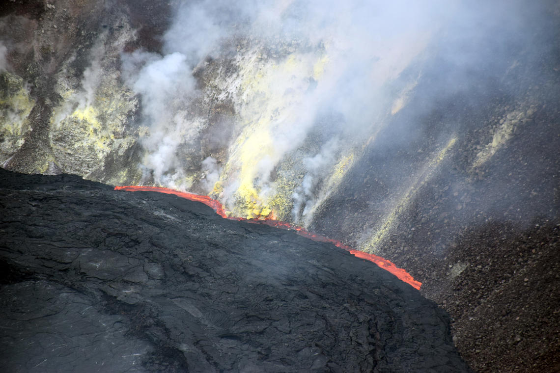
A telephoto view of the eastern Halema‘uma‘u crater wall and portion of the crusted-over lava lake at Kīlauea summit. In this photo, molten lava from below the surface crust has squeezed up between the lava crust and the crater wall as an “ooze-out.”
Observations of the Halema’uma’u lava lake:
Lava effusion from the West Vent continues to feed the lava lake in Halema’uma’u Crater. The West Vent constantly emits low-flow lava through a crusted channel and a submerged inlet into the lake. Lava circulation and intermittent crustal submersion continue in the western part of the lava lake, with lava seeping sporadically in areas along the perimeter of the lake. The total depth of the lake is 225 m (738 ft) this morning, measured by a continuous laser rangefinder over the active western part of the lake. Stagnant and solidified lava crust covers the eastern part of the lava lake and slowly grows west.
Source : HVO.
Photo : USGS/ L. DeSmither ,
Philippines , Taal :
TAAL VOLCANO BULLETIN: 09 April 2021 08:00 A.M.
In the past 24-hour period, the Taal Volcano Network recorded fifty-eight (58) volcanic earthquakes, including fifty-one (51) episodes of volcanic tremors having durations of one (1) to three (3) minutes, one (1) volcano-tectonic event, six (6) low frequency volcanic earthquakes, and an ongoing low-level background tremor that started at 9:05 AM on 08 April 2021.
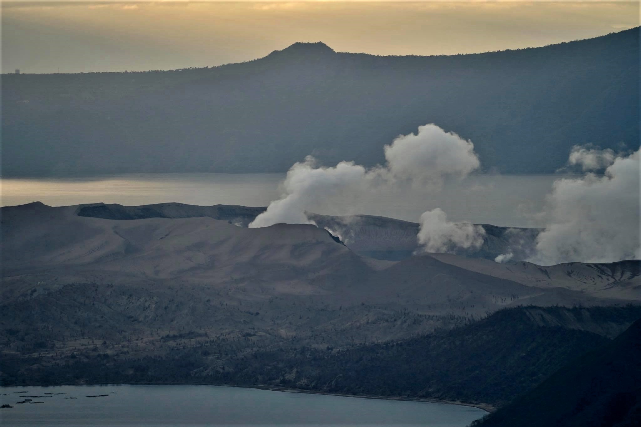
Activity at the Main Crater consisted of weak emission of steam-laden plumes from fumarolic vents that rose five (5) meters. Sulfur dioxide (SO2) emission averaged 1,155 tonnes/day yesterday, 08 April 2021. Temperature highs of 71.8°C and pH of 1.59 were last measured from the Main Crater Lake respectively on 04 March and 12 February 2021. Ground deformation parameters from electronic tilt, continuous GPS and InSAR data analysis indicated a very slow and steady inflation and expansion of the Taal region since after the January 2020 eruption. These parameters indicate magmatic activity at shallow depths beneath the edifice.
Source : Phivolcs
Photo : Raffy Tima .
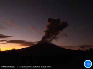
Indonesia , Mérapi :
Two hot avalanche clouds occurred over the Merapi on April 8, 2021 at 10:31 WIB, recorded on a seismogram with an amplitude of 36 mm and a duration of 106 seconds. Sliding distance of ± 1000 meters to the southwest.
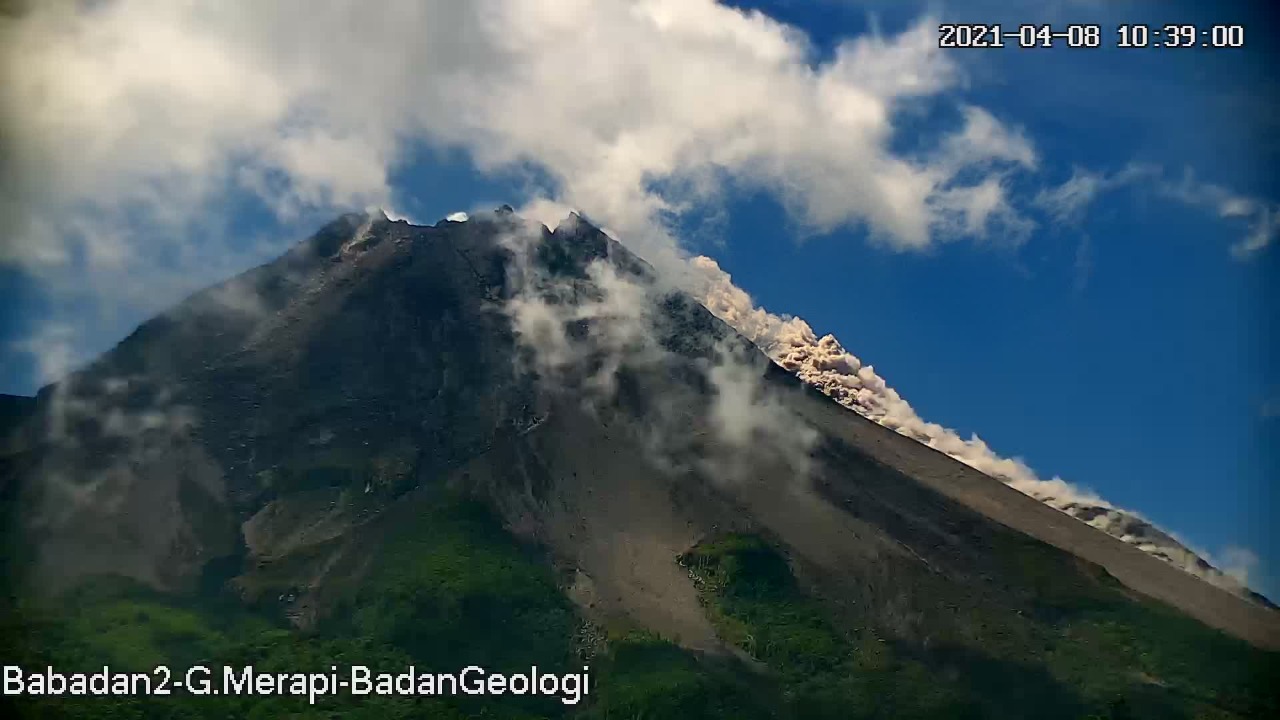
Level of activity level III (SIAGA) since November 5, 2020 at 12:00 WIB. The Merapi volcano (2968 m above sea level) erupted continuously. The last eruption took place on March 27, 2021 with a height of the eruption column 500 m above the summit. We observe that the color of the ash column is gray.
The volcano was clearly visible until it was covered in fog. The crater emits white smoke with strong intensity, about 50 meters above the summit. The weather is sunny to cloudy, with light to moderate winds to the east and southeast. There were 20 lava avalanches with a sliding distance of 900-1000 meters to the southwest, 2 hot avalanche clouds with a distance of 1500 meters to the southwest, 1 lava avalanches with a distance of 500 meters to the southwest.
According to the seismographs of April 8, 2021, it was recorded:
2 hot cloud avalanche earthquakes
127 avalanche earthquakes
7 hybrid / multi-phase earthquakes
1 distant tectonic earthquake.
Source : BPPTKG, PVMBG.