April 01 , 2021 .
Italy / Sicily , Etna :
Press release on ETNA’s activity, March 31, 2021. 12:15 (10:15 UTC).
The National Institute of Geophysics and Volcanology, Osservatorio Etneo, announces that following the previous press release (Etna Update Communication n. 252), it is reported that the thermal anomaly, observed by surveillance cameras from 09:00 UTC around the southern base of the Southeast Crater, is produced by the emission of a lava flow. The latter, observed by INGV staff in the field, is generated by the same field of fractures that fed the lava flows that developed in the same area from March 2021.
On the morning of March 31, 2021, the effusive vent at the base of the Southeast Crater of Etna reactivated, which had emitted lava at the end of some of the paroxysmal episodes of recent weeks.
Compared to press release no. 251, the eruptive activity at the level of the other summit craters remains unchanged. Compared to update 251, no significant changes were observed in seismic and infrasound signals. There are no substantial variations in the time series of incline stations.
The signal from the GNSS summit stations is currently very disturbed and does not allow reliable evaluations.
Press release on ETNA’s activity, March 31, 2021. 18:34 (16:34 UTC).
The National Institute of Geophysics and Volcanology, Osservatorio Etneo, announces that observations made by INGV staff in the field confirm the opening of an effusive vent from the fracture field at the south base of the Southeast Crater .
The effusive vent at 02:30 UTC was active and fed a lava field made up of several lava flows that were propagating in a South-South-West, South and South-South-East direction. During the observation period, the South-South-West and South lava flows seemed poorly fed and their fronts were confined between 2800 and 2900 m altitude. The South-South-East flow was well fed and its front, which reached about 2750 m altitude, had almost reached the edge of the Valle del Bove. Regarding Strombolian activity at the Southeast Crater, no increase in intensity was observed and the activity remains mostly confined in the crater.
Compared to press release no. 251, the eruptive activity at the level of the other summit craters remains unchanged.
The trend of the amplitude of the volcanic tremor remains on average values and for a few hours, is characterized by minor fluctuations in the amplitude, due to a substantial decrease in low frequency transients that characterized the seismic signal until today. morning. The center of gravity of the sources of volcanic tremor remains located in correspondence with the Southeast Crater at an altitude of between 2400 and 2700 m above sea level.
Infrasound activity for a few hours showed a decrease in both the frequency of occurrence and the amplitude of events. The sources are mainly located in the Northeast Crater and the Bocca Nuova / Voragine region.
Data from GNSS and tilt stations do not show substantial variations.
Press release on ETNA’s activity, April 01, 2021. 03:54 (01:54 UTC).
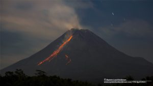
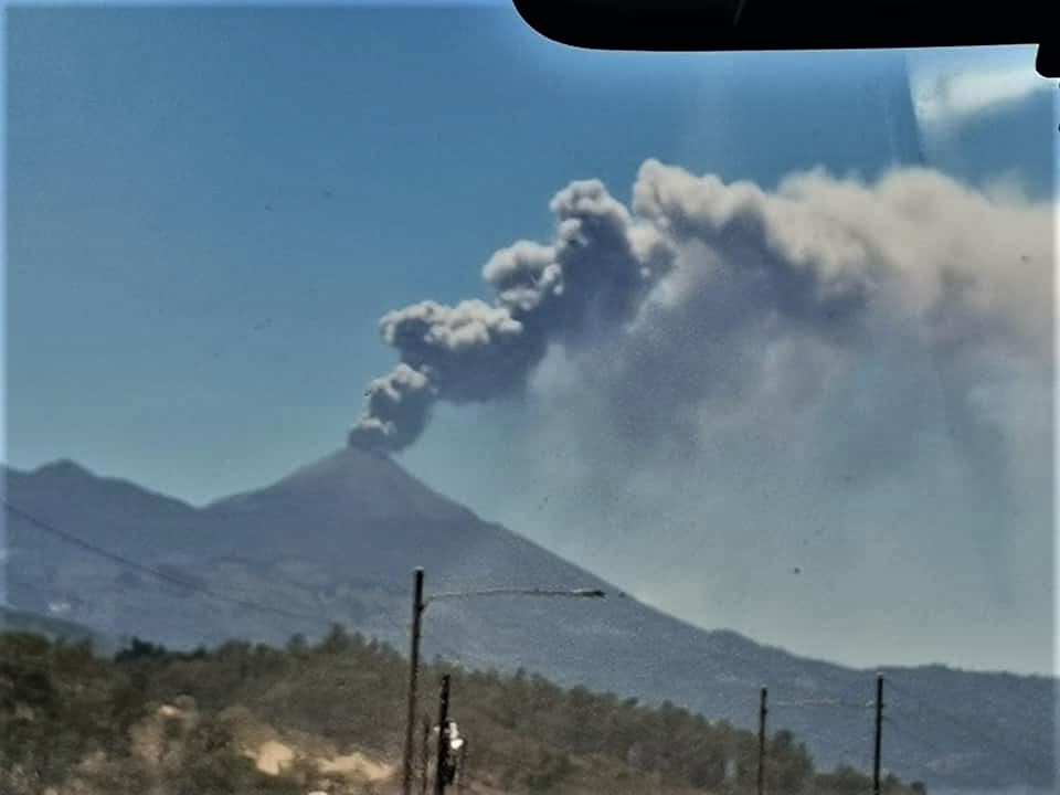
From around 23:00 UTC on March 31, the Strombolian activity of the Southeast Crater gradually turned into a lava fountain. According to the forecast model, the ash cloud, which reached a height of about 7000 m above sea level, disperses in a south-southwest direction.
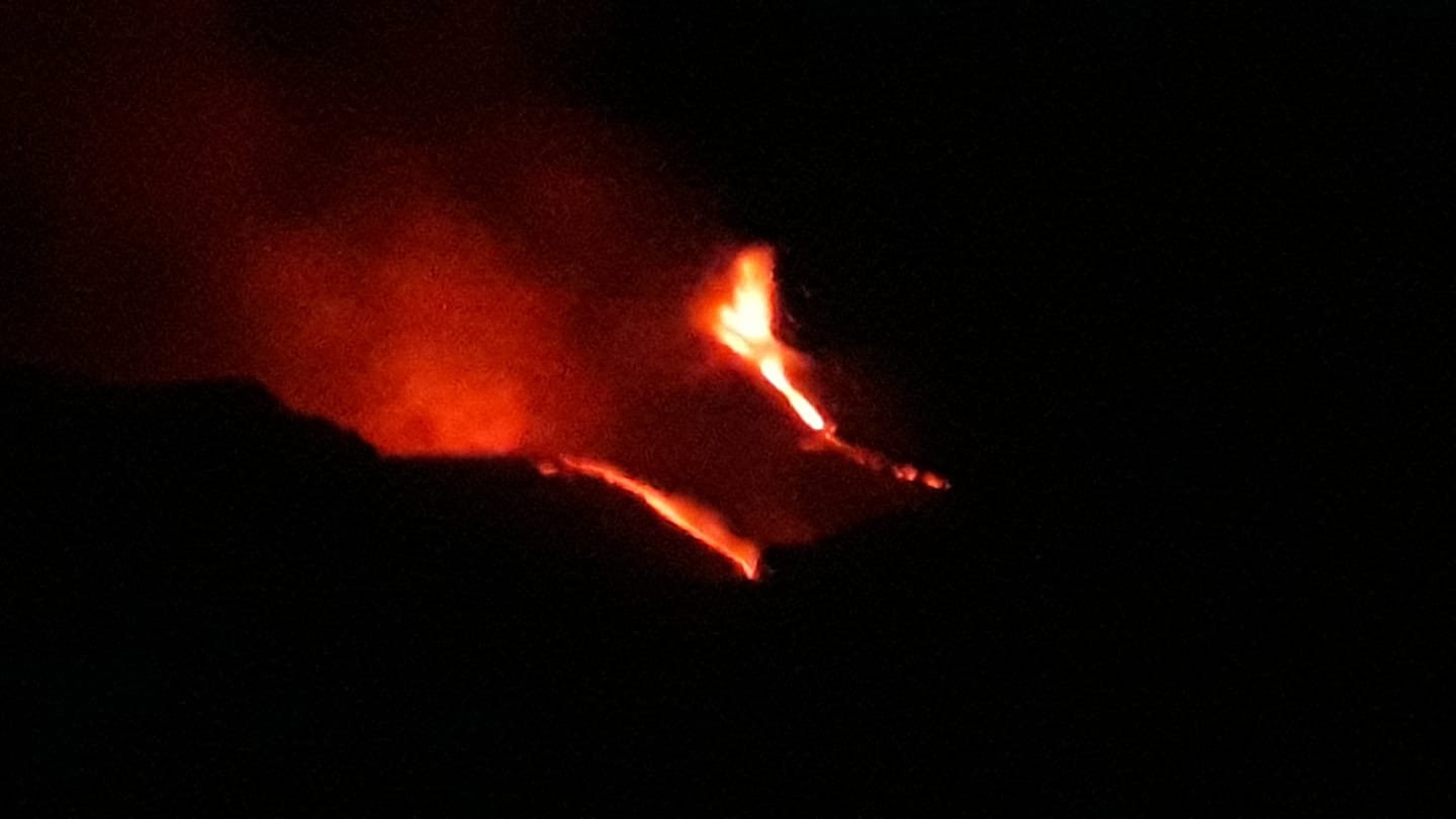
At the same time, from 00:18 UTC on April 1, an overflow of lava can be observed from the eastern edge of the Southeast Crater which develops in the upper part of the Valle del Bove.
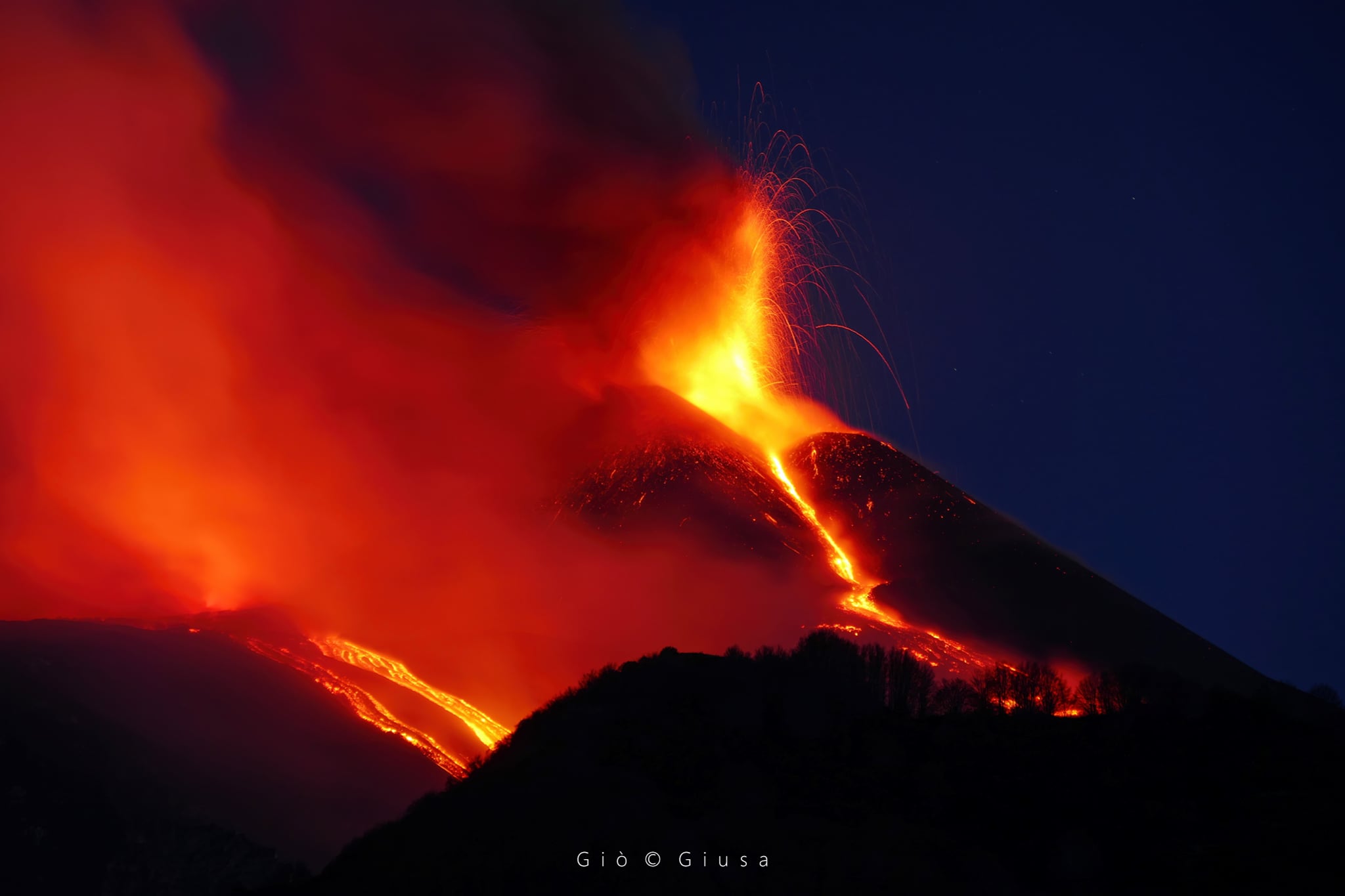
In addition, effusive activity continues from the active vent at the southern base of the Southeast Crater. This vent produces a weak explosive activity and continues to feed the South-South-East lava flow which flows into the western sector of the Valle del Bove.
Compared to what has been previously reported, the eruptive activity at the level of the other summit craters remains unchanged.
The temporal evolution of the amplitude of the volcanic tremor shows a continuous increase in values which have reached very high levels. The center of gravity of the sources of volcanic tremor is located in correspondence with the Southeast Crater at an altitude of between 2,500 and 2,800 m above sea level.
The infrasonic activity reached very high levels, characterized by infrasonic events and tremors located in the Southeast Crater.
A modest variation equal to about 0.4 microradians is visible in the time series of the X and Y components of the inclination of the Cratere del Piano station, while no significant variation is present in the data of the GNSS network.
Further updates will be communicated shortly
Source : INGV.
Photo : Tullio Ricci /INGV Roma. Gio Giusa
Japan , Sakurajima :
JMA reported that during 22-26 March incandescence from Minamidake Crater (at Aira Caldera’s Sakurajima volcano) was visible nightly. An explosion on 25 March produced an eruption plume that rose 1.4 km above the crater rim. On 27 March at 0236 an eruption generated an ash plume that rose 2.5-4 km above the crater rim and drifted NW, resulting in a large amount of ashfall in Kagoshima City (about 10 km W).
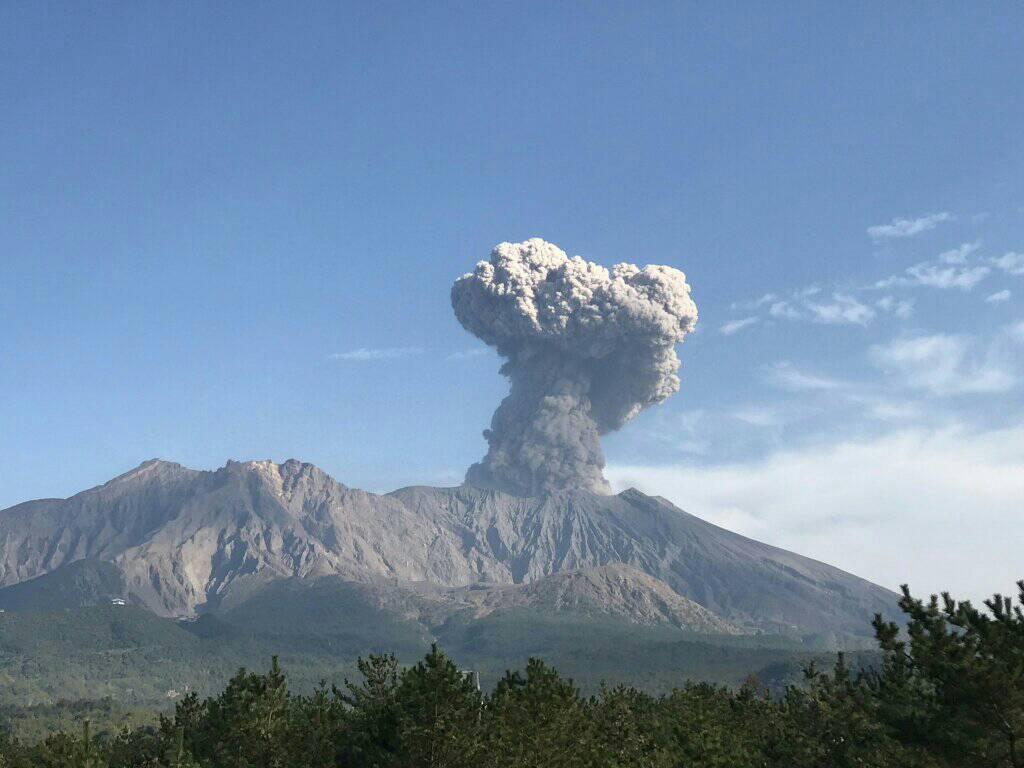
Volcanic bombs were ejected 1-1.3 km away from the crater. An eruption on 29 March at 1557 produced an eruption plume that rose 2.2 km above the crater rim and drifted SE, resulting in a pyroclastic flow down the SE flank and ashfall in Kagoshima City and the Kagoshima Prefecture. An explosion on 30 March at 0433 generated an ash plume that rose 2.7 km above the crater and drifted E, ejecting bombs 600-900 m from the crater. Ashfall was again reported in Kagoshima City. The Alert Level remained at 3 (on a 5-level scale).
Source : GVP.
Photo : Rizal M.
La Martinique , Montagne Pelée :
Weekly report on the activity of Mount Pelée for the period from March 19 to 26, 2021
Seismicity of volcanic origin has increased over the past week. None of these earthquakes were felt by the population. Between March 19, 2021 4:00 p.m. UT (local time + 4h) and March 26, 2021 4:00 p.m. UT (local time + 4h), the OVSM recorded at least 55 volcano-tectonic earthquakes of magnitude less than or equal to 1.0 , located at shallow depth inside the volcanic edifice, between 1.7 km below sea level and 1.0 km above sea level. Superficial volcano-tectonic seismicity, characterized by signals of high frequencies, is associated with micro-fracturing in the volcanic edifice.
During the period of this report, OVSM again recorded a volcanic tremor-type signal on March 24, 2021. These signals containing low frequencies are associated with the migration of fluids in the volcanic edifice.
During phases of volcanic reactivation, it is common for periods of higher seismic activity to alternate with phases of weaker seismicity. The seismicity of volcanic origin remains clearly above the average base level recorded between January 1, 2015 and April 2019 (date of the start of its increase).
L’Observatoire Volcanologique et Sismologique de Martinique (OVSM) reported that seismicity at Pelée increased during 19-26 March. The seismic network recorded at least 55 high-frequency volcano-tectonic earthquakes with magnitudes less than or equal to 1, located at depths between 1.7 km below sea level and 1 km above sea level. The Alert Level remained at Yellow (the second lowest level on a four-color scale).
Source : OVSM/IPGP , GVP.
Photo : Ville-Saintemarie.
Guatemala , Pacaya :
SPECIAL VOLCANOLOGICAL BULLETIN.
UPDATE ON ERUPTIVE AND EFFUSIVE ACTIVITY
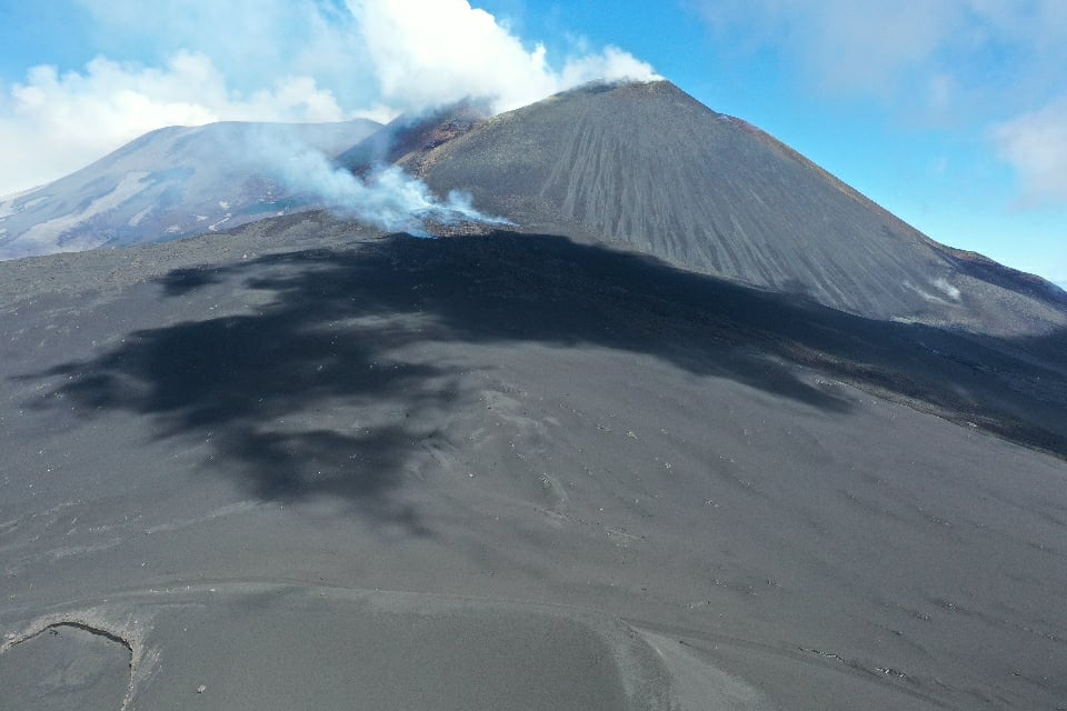
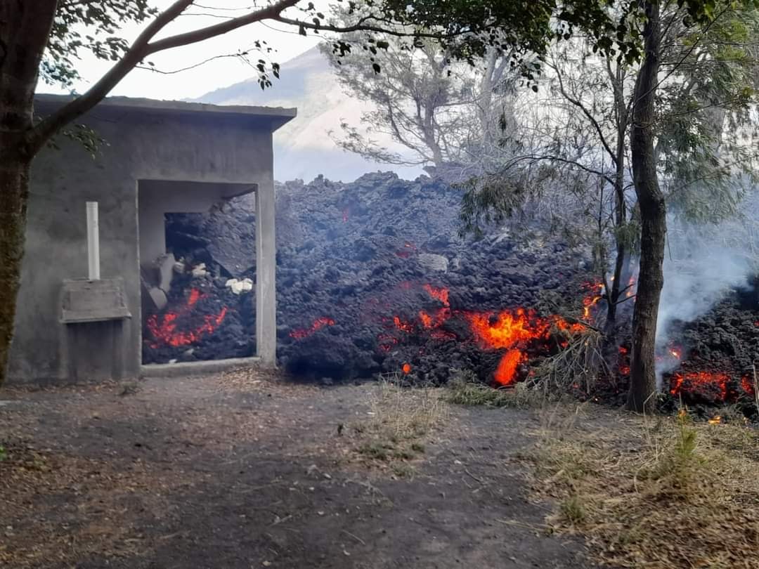
The eruption of the Pacaya volcano continues to generate explosive activity in the Mackenney crater, which has expressed itself in recent hours through columns of ash, water vapor and other magmatic gases that rise to heights between 3000 and 4300 meters of altitude (9482 and 14108 feet approximately), moving towards the South, the South-West, the West and the North-West, over distances of up to 50 kilometers or more depending on the wind speed and direction. Explosions are sometimes heard and ballistic projections of blocks are ejected at heights of up to 150 meters above the crater. Effusive activity on the western flank continues with the reactivation of the front of the lava flow at the place known as La Breña, which again moved west, while the front of the farm Campo Alegre has stopped for the moment; the total length of the stream exceeds 3000 meters. The movement of the magma that feeds this lava flow produces seismic tremors recorded by the seismic stations around the volcano.
Lava flows cause fires in the vegetation and crops it encounters, as well as the destruction of buildings and the permanent disruption of roads. Glowing blocks are released from the lava flow which can cause severe burns and injury, as well as magmatic gases such as sulfur dioxide, which can cause respiratory damage and poisoning if inhaled.
Given the high level of activity that the Pacaya volcano has shown in recent weeks, it is not excluded that increasing pulses will continue to occur in the coming hours or days, generating explosions, eruptive columns, sources of incandescent material, ballistic projections and ash fall and / or the appearance of new lava flows or the increase in their length.
INSIVUMEH reported moderate to s trong explosions at Pacaya’s Mackenney Crater during 24-30 March, accompanied by abundant ash plumes that rose to 2.9-4.5 km (9,500-13,000 ft) a.s.l. and drifted in multiple directions as far as 15-20 km. Resulting ashfall was reported in El Pepinal (7 km N), San Francisco de Sales (5 km N), El Cedro (9 km NNW), Calderas (3 km N), Mesías Altas, Mesías Baja (5 km NE), El Rodeo (4 km WSW), El Patrocinio (5 km W), and San Vicente Pacaya (5 km NW).
The lava flow that began on 18 March was 2.5 km long, continuing down the SW flank; the height of the flow was 2.5 m with a width of 400 m, but the advancing front was 250 wide and set fire to nearby vegetation. Incandescent material ejected 150-300 m above the rim fell around the crater on 25 and 27 March. On 30 March ash plumes drifted 7 km S, causing ashfall in El Chupadero (2-2.5 km S) and Los Pocitos (5.5 km S).
Source : Insivumeh , GVP.
Photos : Carmen Morataya de Rehnberg , Melvin Santisteban Torres via Jeannie Curtis ,
Japan , Asamayama :
On 23 March JMA raised the Alert Level for Asamayama to 2 (on a scale of 1-5), noting slight inflation on the W side of the volcano since 15 March and an increase in the number of daily volcanic earthquakes that have occurred since 20 March (36 recorded on 20 March and increasing to 77 events by 1500 on 23 March). After 23 March the number of daily volcanic earthquakes began to fluctuate, decreasing to 15 on 28 March and then 23 by 1500 on 29 March. The sulfur dioxide emission rate was 800 tons per day (t/d) on 22 March, 400 t/d on 24 March, and 700 t/d on 25 March, compared to the previous measurement of 200 t/d on 25 February.

Asamayama, Honshu’s most active volcano, overlooks the resort town of Karuizawa, 140 km NW of Tokyo. The volcano is located at the junction of the Izu-Marianas and NE Japan volcanic arcs. The modern Maekake cone forms the summit and is situated east of the horseshoe-shaped remnant of an older andesitic volcano, Kurofuyama, which was destroyed by a late-Pleistocene landslide about 20,000 years before present (BP). Growth of a dacitic shield volcano was accompanied by pumiceous pyroclastic flows, the largest of which occurred about 14,000-11,000 BP, and by growth of the Ko-Asama-yama lava dome on the east flank. Maekake, capped by the Kamayama pyroclastic cone that forms the present summit, is probably only a few thousand years old and has an historical record dating back at least to the 11th century CE. Maekake has had several major plinian eruptions, the last two of which occurred in 1108 (Asamayama’s largest Holocene eruption) and 1783 CE.
Source : GVP.
Photo : Yu Nakai .