November 14, 2020. EN. Kamchatka : Klyuchevskoy , Hawaii : Mauna Loa , Indonesia : Merapi , Ecuador : Reventador , Mexico : Popocatepetl .

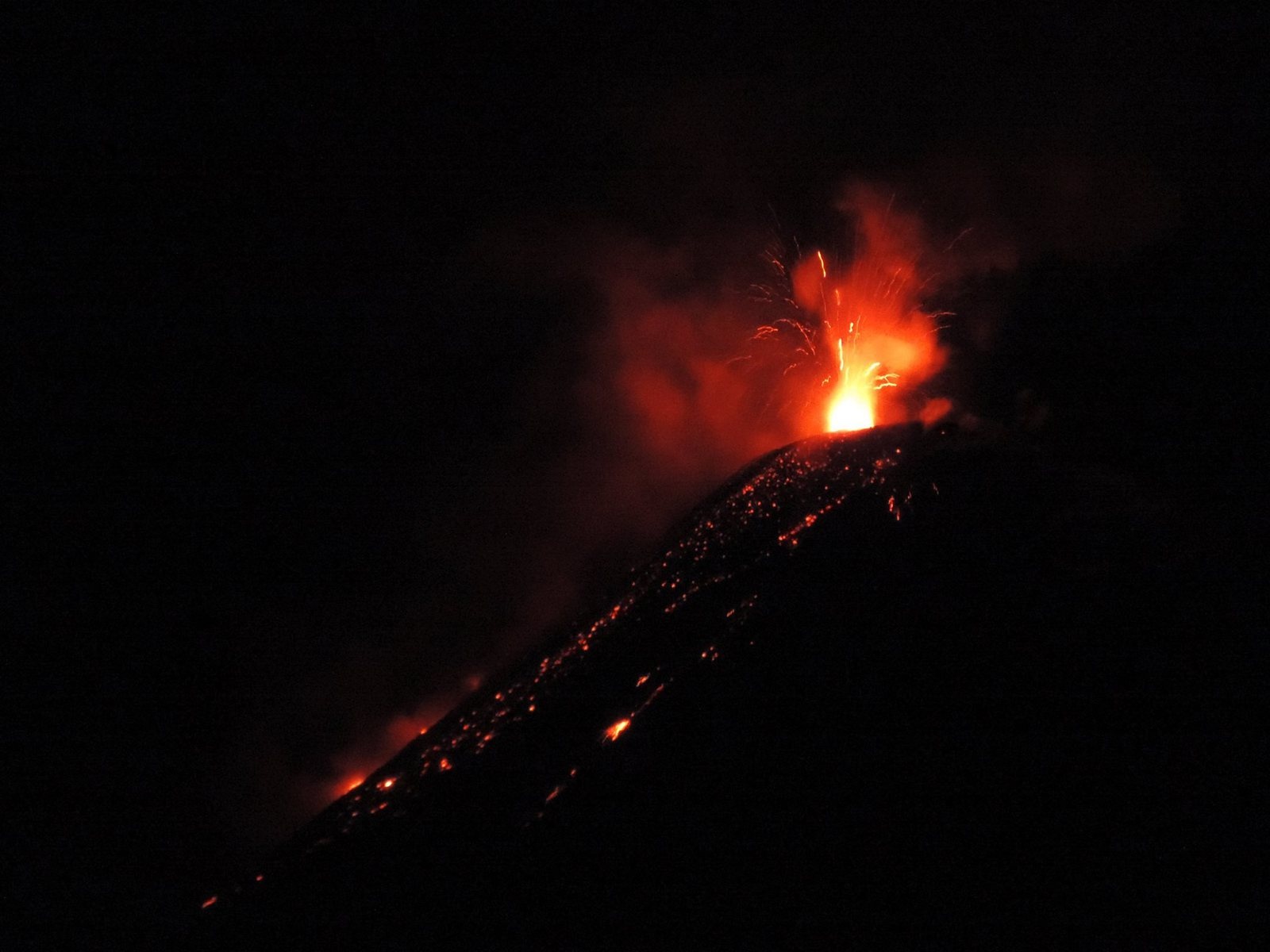
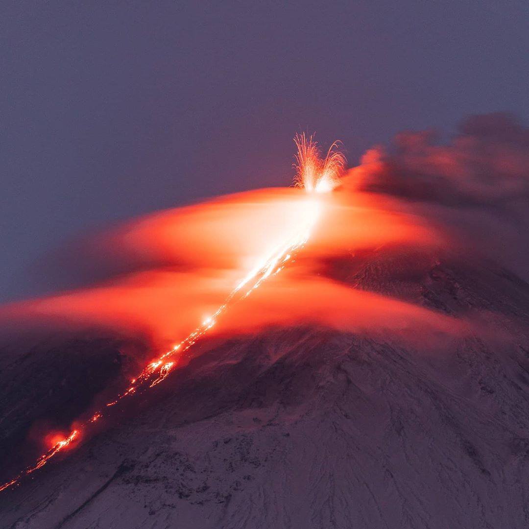
November 14 , 2020.


Kamchatka , Klyuchevskoy :

56.06 N, 160.64 E;
Elevation 15580 ft (4750 m)
Aviation Colour Code is ORANGE

A moderate explosive-effusive eruption of the volcano continues. Ash explosions up to 19,700-23,000 ft (6-7 km) a.s.l. could occur at any time. Ongoing activity could affect low-flying aircraft.

This eruption of the volcano continues, the Strombolian and gas-steam activity with some amount of ash is observing. The lava flow continues to move along Apakhonchich chute on the southeastern volcanic flank. Satellite data showed a large bright thermal anomaly in the area of the volcano all week; gas-steam plumes containing some amount of ash extended for 85 km to the east of the volcano on 07-09 November.

Source : Kvert.

Photo : Камчатский Репортёр via Sherine France .


Hawaii , Mauna Loa :

19°28’30 » N 155°36’29 » W,
Summit Elevation 13681 ft (4170 m)
Current Volcano Alert Level: ADVISORY
Current Aviation Color Code: YELLOW

Activity Summary:
Mauna Loa Volcano is not erupting. Rates of deformation and seismicity have not changed significantly over the past week and remain above long-term background levels.


Observations:
During the past week, HVO seismometers recorded 89 small-magnitude earthquakes across the whole volcano, 26 of which were under the volcano’s summit and upper-elevation flanks. Most of these earthquakes occurred at shallow depths of less than 8 kilometers (~5 miles) below ground level.

Global Positioning System (GPS) measurements show overall continued slow summit inflation, consistent with magma supply to the volcano’s shallow storage system. A minor shortening of the line length across the summit has been occurring since a small earthquake flurry at the end of October and early November.

Gas concentrations and fumarole temperatures at both the summit and Sulphur Cone on the Southwest Rift Zone remain stable.

Webcam views have revealed no changes to the landscape over the past week.

Source et photo : HVO.


Indonesia , Merapi :

Mount Merapi Activity Report, November 6-12, 2020

OBSERVATION RESULTS
Visual
The weather around Mount Merapi is generally sunny in the morning, while the afternoon until evening is foggy. There is a white smoke, thin to thick in thickness with low pressure. A maximum smoke height of 250 m was observed from the Selo observation post on November 8, 2020 at 2:50 p.m. Avalanches were observed from the observation post of Mount Merapi in Babadand with a maximum sliding distance of 3 km in the western sector upstream of Kali Sat on November 8 at 12:57 p.m.
Morphological analysis of the crater area based on photos of the southeast sector from November 11, 2020 showed no change in the morphology of the dome. The calculation of the volume of the lava dome from measurements using aerial photos with drones on November 3, 2020, is 200,000 m3.

Seismicity
This week, the seismicity of Mount Merapi recorded:
244 shallow volcanic earthquakes (VTB),
2,189 multiphase earthquakes (MP),
9 low frequency earthquakes (LF),
385 avalanche earthquakes (RF),
403 emission earthquakes (DG)
6 tectonic earthquakes (TT).

The seismic intensity this week is higher than last week.

Deformation
The deformation of Mount Merapi which was monitored by EDM this week showed a shortening rate of 10cm / day.

Rain and lahars:
This week, there was rain at the Mount Merapi observation post with the highest rainfall intensity of 34 mm / hour for 35 minutes at Ngepos post on November 11, 2020. There was no rain. laharse or additional flow in the rivers that descend from Mount Merapi.

Conclusion:
Based on the results of visual and instrumental observations, it is concluded that:
There is an increase in volcanic activity on Mount Merapi, so the activity status is defined as the activity level « SIAGA »

Current potential dangers come in the form of lava avalanches, eruption of volcanic material in the event of an explosive eruption, and hot cloud avalanches up to a maximum of 5 km.

Source : PVMBG.

Photos : Frekom , Klangon.


Ecuador , Reventador :

DAILY REPORT OF THE STATE OF THE REVENTADOR VOLCANO, Friday 13 November 2020.
Information Geophysical Institute – EPN.

Surface activity level: High, Surface trend: Increasing.
Internal activity level: High, Internal trend: No change.

Seismicity: From November 12, 2020, 11:00 a.m. to November 13, 2020, 11:00 a.m.
Explosions (EXP): 82 events.
Long periods (LP): 87 events.
Emission tremor (TE): 11 events.

Rains / lahars: No rains were recorded in the area.

Emission / ash column: Several gas and ash emissions were observed which rose between 800 and 1000 meters above the level of the crater, the direction of these emissions was mainly towards the North-West. The VAAC reported 3 alerts of emissions observed by satellites, which reached altitudes between 700 and 1000 meters above crater level and the directions of these emissions varied between East, North and Northwest .

Other monitoring parameters: No notable change. No thermal alert recording for the Reventador.

Observations: In the afternoon and at night of yesterday for several moments the volcano was cleared allowing to observe the described emissions and at night the incandescence in the crater accompanied by the rolling of blocks on the sides of the volcano. The lava flow is still active (~ 450 m) in the northeast and without notable changes.

Alert level: Orange.

Source : IGEPN.

Photo : Benjamin Bernard.


Mexico , Popocatepetl :

November 13, 11:00 a.m. (November 13, 5:00 p.m. GMT)

During the last 24 hours, according to the monitoring systems of the Popocatépetl volcano, 307 exhalations have been identified, accompanied by emissions of water vapor, volcanic gases and small amounts of ash). In addition, 22 minutes of low amplitude tremor were recorded.

During the morning and at the time of this report, the volcano was observed with a slight emission of water vapor, gas and ash which disperses towards the northwest.

CENAPRED urges not to go as close as possible to the volcano and in particular to the crater, because of the danger posed by the fall of ballistic fragments and, in the event of heavy rains, to stay away from the bottom of the ravines due to the danger of mudslides and debris.

The Popocatépetl volcanic alert semaphore is in YELLOW PHASE 2.

Source : Cenapred.

14 Novembre 2020. FR. Kamchatka : Klyuchevskoy , Hawaii : Mauna Loa , Indonésie : Merapi , Equateur : Reventador , Mexique : Popocatepetl .

14 Novembre 2020.


Kamchatka , Klyuchevskoy :

56,06 N, 160,64 E;
Altitude : 15580 pi (4750 m)
Code couleur de l’aviation : ORANGE

Une éruption explosive-effusive modérée du volcan se poursuit. Des explosions de cendres jusqu’à 19,700-23,000 ft (6-7 km) d’altitude pourraient survenir à tout moment. L’ activité en cours pourrait affecter les aéronefs volant à basse altitude.

Cette éruption du volcan se poursuit, une activité strombolienne et des émissions gaz-vapeur avec une certaine quantité de cendres sont observée. La coulée de lave continue de se déplacer le long de la ravine d’Apakhonchich sur le flanc volcanique Sud-Est. Les données satellitaires ont montré une grande anomalie thermique lumineuse dans la zone du volcan toute la semaine; des panaches de gaz-vapeur contenant une certaine quantité de cendres se sont étendus sur 85 km à l’Est du volcan les 7 et 9 novembre.

Source : Kvert.

Photo : Камчатский Репортёр via Sherine France .


Hawaii , Mauna Loa :

19 ° 28’30 « N 155 ° 36’29 » W,
Altitude du sommet  :13681 pi (4170 m)
Niveau d’alerte volcanique actuel: AVIS
Code couleur de l’aviation actuel: JAUNE

Résumé de l’activité:
Le volcan Mauna Loa n’est pas en éruption. Les taux de déformation et de sismicité n’ont pas changé de manière significative au cours de la semaine dernière et restent au-dessus des niveaux de fond à long terme.


Observations:
Au cours de la semaine dernière, les sismomètres du HVO ont enregistré 89 tremblements de terre de petite magnitude sur tout le volcan, dont 26 sous le sommet du volcan et les flancs en altitude. La plupart de ces tremblements de terre se sont produits à de faibles profondeurs de moins de 8 kilomètres (~ 5 miles) sous le niveau du sol.

Les mesures du système de positionnement global (GPS) montrent une inflation globale continue lente au sommet, compatible avec l’apport de magma au système de stockage peu profond du volcan. Un léger raccourcissement de la longueur de la ligne qui traverse le sommet s’est produit depuis une petite rafale de tremblement de terre à la fin d’octobre et au début de novembre.

Les concentrations de gaz et les températures des fumerolles au sommet et à Sulphur Cone dans la zone du Rift Sud-Ouest restent stables.

Les vues de la webcam n’ont révélé aucun changement dans le paysage au cours de la semaine dernière.

Source et photo : HVO.


Indonésie , Merapi :

Rapport d’activité du mont Merapi, du 6 au 12 novembre 2020

RÉSULTATS DE L’OBSERVATION
Visuel
Le temps autour du mont Merapi est généralement ensoleillé le matin, tandis que l’après-midi jusqu’au soir est brumeuse. On note une fumée blanche, d’épaisseur fine à épaisse avec une faible pression. Une hauteur de fumée maximale de 250 m a été observée depuis le poste d’observation de Selo le 8 novembre 2020 à 14h50 . Des avalanches ont été observées depuis le poste d’observation du Mont Merapi de Babadand avec une distance de glissement maximale de 3 km dans le secteur Ouest en amont de Kali Sat le 8 novembre à 12h57  .
L’analyse morphologique de la zone du cratère basée sur des photos du secteur Sud-Est du 11 novembre 2020 n’a montré aucun changement dans la morphologie du dôme. Le calcul du volume du dôme de lave à partir de mesures à l’aide de photos aériennes avec drones le 3 novembre 2020, est de 200000 m3.  

Sismicité
Cette semaine, la sismicité du mont Merapi a  enregistré:
244 tremblements de terre volcaniques peu profonds (VTB),
2,189 séismes multiphases (MP),
9 tremblements de terre de basse fréquence (LF),
385 tremblements de terre d’avalanches (RF),
403 tremblements de terre d’émissions (DG)
6 tremblements de terre tectoniques (TT).

L’intensité sismique cette semaine est plus élevée que la semaine dernière.

Déformation
La déformation du mont Merapi qui a été surveillée par EDM cette semaine a montré un taux de raccourcissement de 10 cm / jour. 

Pluie et lahars :
Cette semaine, il y a eu de la pluie au poste d’observation du mont Merapi avec la plus forte intensité de pluie de 34 mm / heure pendant 35 minutes au poste de Ngepos le 11 novembre 2020. Il n’y a pas eu de laharse ou d’écoulement supplémentaire dans les rivières qui descendent du mont Merapi.

Conclusion :
Sur la base des résultats des observations visuelles et instrumentales, il est conclu que:
 Il y a une augmentation de l’activité volcanique du mont Merapi, de sorte que le statut d’activité est défini comme le niveau d’activité «SIAGA  »

Les dangers potentiels actuels se présentent sous la forme d’avalanches de lave, d’éruption de matière volcanique en cas d’éruption explosive et d’avalanches de nuages ​​chauds jusqu’à un maximum de 5 km.

Source : PVMBG.

Photos : Frekom , Klangon.


Equateur , Reventador :

RAPPORT QUOTIDIEN DE L’ETAT DU VOLCAN REVENTADOR , Vendredi 13 Novembre 2020.
Information Geophysical Institute – EPN.

Niveau d’activité Superficiel: Haut , Tendance de surface : En hausse .
Niveau d’activité interne: Haut , Tendance interne : Pas de changement.

Sismicité : Du 12 Novembre 2020, 11:00h au 13 Novembre 2020, 11:00h :
Explosions (EXP): 82 événements.
Longues périodes ( LP) : 87 événements.
Tremor d’émission  (TE) : 11 événements.

Pluies / lahars: Il n’a pas été enregistré de pluies dans le secteur .


Emission / colonne de cendres: Plusieurs émissions de gaz et de cendres ont été observées qui s’élevaient entre 800 et 1000 mètres au-dessus du niveau du cratère, la direction de ces émissions était majoritairement vers le Nord-Ouest. Le VAAC a signalé 3 alertes d’émissions observées par des satellites, qui atteignaient des altitudes comprises entre 700 et 1000 mètres au-dessus du niveau du cratère et les directions de ces émissions variaient entre l’Est, le Nord et le Nord-Ouest.

Autres paramètres de surveillance: Aucun changement notable. Aucun enregistrement d’alerte thermique pour  le Reventador.

Observations: Dans l’après-midi et la nuit d’hier pendant plusieurs instants le volcan était dégagé permettant d’observer les émissions décrites et la nuit l’incandescence dans le cratère accompagnée du roulement de blocs sur les flancs du volcan. La coulée de lave est toujours active (~ 450 m) au Nord-Est et sans changements notables .

Niveau d’alerte: Orange.

Source : IGEPN.

Photo : Benjamin Bernard.


Mexique , Popocatepetl :

13 novembre, 11h00 (13 novembre, 17h00 GMT)

Au cours des dernières 24 heures, selon les systèmes de surveillance du volcan Popocatépetl, 307 exhalaisons ont été identifiées, accompagnées d’émissions de vapeur d’eau, de gaz volcaniques et de faibles quantités de cendres ). De plus, 22 minutes de tremor de faible amplitude ont été enregistrées.

Au cours de la matinée et au moment de ce rapport , le volcan a été observé avec une légère émission de vapeur d’eau, de gaz et de cendres qui se disperse vers le Nord-Ouest .

Le CENAPRED exhorte à ne pas aller au plus près du volcan et en particulier du cratère, en raison du danger posé par la chute de fragments balistiques et, en cas de fortes pluies, de rester à l’écart du fond des ravins en raison du danger de coulées de boue et de débris.

Le sémaphore d’alerte volcanique du Popocatépetl est en PHASE JAUNE 2.

Source : Cenapred.

November 13, 2020. EN . Kamchatka : Karymsky , New Zealand : White Island , Chile : Villarica , Indonesia : Sinabung .

November 13 , 2020.


Kamchatka , Karymsky :

54.05 N, 159.44 E;
Elevation 4874 ft (1486 m)
Aviation Colour Code is ORANGE

A moderate eruptive activity of the volcano continues. Ash explosions up to 19,700-23,000 ft (6-7 km) a.s.l. could occur at any time. Ongoing activity could affect low-flying aircrafts.

A moderate eruptive activity of the volcano continues. According to satellite data by KVERT, explosions sent ash up to 8 km a.s.l. on 08 November; ash plumes and clouds drifted for 230 km to the northeast of the volcano. A thermal anomaly over the volcano was noted on 07-09 and 12 November.

Source : Kvert .

Photo : Belkamtour


New Zealand , White Island :

Minor ash emission at Whakaari/White Island. Volcanic Alert Level raised to Level 2.
Published: Fri Nov 13 2020 4:35 PM

Volcanic Alert Level is raised to 2
Aviation Colour Code is raised to Yellow

New observations show small amounts of volcanic ash being carried in the steam and gas plume at Whakaari/White Island and deposited on the island’s webcams. The Volcanic Alert Level is now raised to Level 2.

Following a period of severe wet weather, scientists completed a gas monitoring and observation flight over Whakaari/White Island on Thursday 12 November 2020. Some occasional deposits had been observed on some of the islands’ webcams, and a darker than usual plume was also reported at times from the mainland.

Observations during the flight confirmed the presence of some fine material (ash) in the plume. The fine particles originate from the main steam vent at the back of the crater lake. Initial analyses of the ash particles suggest that it is loose material from around the vent or underlying conduit being carried by the steam and gas emission.

While the gas output observed on Thursday is higher than recent observations, other monitoring parameters do not show significant changes. The Volcanic Alert Level is now raised to Level 2 in response to these observations of vent activity and monitoring data.

Observations from the flight show there is no substantial change in the location and size of active vents. The rainfall has formed a pool of water on the floor of the 1978/90 Crater, re-forming a shallow lakelet. During the past week, a small sequence of earthquakes has been located close to the volcano and we had several episodes of slightly increased volcanic tremor. None of these observations are unusual for Whakaari/White Island and it remains unclear whether these are just coincidental with the incorporation of material in the plume.

During fine weather conditions, moderate to large gas-steam plumes will be seen rising above the island and trailing off downwind. Some of the particles may be carried a few kilometres downwind but are unlikely to reach the mainland. Should any explosive activity produce a significant ash cloud, the likelihood of ash affecting the mainland remains very low. The gas and steam plume may be noticed on the mainland as weak acid rain.

The changes at the vent resulting in the minor ash emissions have not been observed at Whakaari/White Island in 2020 and indicate a greater level of unrest at the surface. There are no indications currently of a substantial change in the overall behaviour of the volcano. The main plausible triggers for a sudden eruption with little or no warning remain the collapse of unstable material in an active vent and the possible ingress of water underground onto the shallow magma body.

Overall, recent observations are consistent with moderate-heightened volcanic unrest and, therefore, the Volcanic Alert Level is raised to Level 2 and the Aviation Colour Code to Yellow.

The Volcanic Alert Level reflects the current level of volcanic unrest or activity and is not a forecast of future activity.

GNS Science and our National Geohazards Monitoring Centre continue to closely monitor Whakaari/White Island continuously for changes in activity. Further updates will be provided as needed.

Source : Geonet /  Yannik Behr (Duty Volcanologist)

Photos : Rotorua Daily Post , Geonet .


Chile , Villarica :

Special Report on Volcanic Activity (REAV), La Araucanía region, Villarrica volcano, November 10, 2020, 4:30 p.m. local time (Continental Chile).

The National Service of Geology and Mines of Chile (Sernageomin), on the basis of information obtained through the monitoring equipment of the National Volcanic Surveillance Network (RNVV), processed and analyzed at the Volcanological Observatory of the Andes of the South ( Ovdas), and in relation to the activity of the Villarrica volcano, reports the following:

On Tuesday, November 10, at 3:14 p.m. local time (6:14 p.m. UTC), the IP cameras installed near the volcano recorded a pulsatile gas emission with emission of particulate matter associated with continuous tremor-type seismicity.

The data obtained are as follows:
MAXIMUM HEIGHT OF THE COLUMN: 320 m with particle emission.
DISPERSAL DIRECTION: South-South-West (SSO).

REDUCED DISPLACEMENT VALUE OF THE CONTINUOUS TREMOR: 3.9 cm2.

It is important to emphasize that during this day, explosions were recorded, with magnitudes of lower amplitude than that described.

The volcanic alert remains at the Yellow level.

Source : Sernageomin .


Indonesia , Sinabung :

The activity level has been at level III (SIAGA) since May 20, 2019 at 10:00 a.m. WIB. The Sinabung volcano (2460 m altitude) has been erupting since 2013.

The volcano was clear until it was covered in fog. The main crater emits white smoke with a moderate height, thick, about 50 to 500 m above the peak. The weather is cloudy to rainy, with light to moderate winds to the east, south-east, south-west and north-west. The air temperature is around 17-26 ° C. Hot avalanche clouds were observed with a sliding distance of 1500 m to the east and south-east. Lava avalanches were observed with a sliding distance of 200 to 500 m from the summit to the east and south-east.

According to the seismographs of November 12, 2020, it was recorded:

1 hot cloud avalanche earthquake
32 avalanche earthquakes
4 emissions earthquakes
21 low frequency earthquakes
3 hybrid / multiphase earthquakes
3 local tectonic earthquakes
1 remote tectonic earthquake.


Recommendation:

The public and visitors / tourists should not carry out activities in the villages that have been relocated, as well as within a radial radius of 3 km around the summit of G. Sinabung, and a sector radius of 5 km for the southern sector. -East and 4 km for the East-North sector.

Source : PVMBG.

Vidéo et photo :  Beidar sinabung .


13 Novembre 2020. FR . Kamchatka : Karymsky , Nouvelle Zélande : White Island , Chili : Villarica , Indonésie : Sinabung .

13 Novembre 2020.


Kamchatka , Karymsky :

54,05 N, 159,44 E;
Élévation : 4874 pi (1486 m)
Code couleur de l’aviation : ORANGE

Une activité éruptive modérée du volcan se poursuit. Des explosions de cendres jusqu’à 19,700-23,000 ft (6-7 km) d’altitude pourraient survenir à tout moment. L’activité en cours pourrait affecter les avions volant à basse altitude.

Cette activité continue . Selon les données satellitaires du KVERT, des explosions ont envoyé des cendres jusqu’à 8 km d’altitude le 08 novembre .Des panaches de cendres et des nuages ont dérivé sur 230 km au Nord-Est du volcan. Une anomalie thermique sur le volcan a été notée les 07-09 et 12 novembre.

Source : Kvert .

Photo : Belkamtour


Nouvelle Zélande , White Island :

Émissions mineures de cendres sur Whakaari / White Island. Niveau d’alerte volcanique élevé au niveau 2.
Publié: Ven 13 nov.2020 16:35

Le niveau d’alerte volcanique est augmenté à 2
Le code couleur de l’aviation passe au jaune

De nouvelles observations montrent de petites quantités de cendres volcaniques transportées dans le panache de vapeur et de gaz sur Whakaari / White Island et déposées sur les webcams de l’île. Le niveau d’alerte volcanique est maintenant élevé au niveau 2.

Après une période de temps très pluvieux, les scientifiques ont effectué un vol de surveillance et d’observation des gaz au-dessus de Whakaari / White Island le jeudi 12 novembre 2020. Des dépôts occasionnels avaient été observés sur certaines des webcams des îles, et un panache plus sombre que d’habitude a également été signalé, parfois depuis le continent.

Les observations pendant le vol ont confirmé la présence de certains matériaux fins (cendres) dans le panache. Les fines particules proviennent de l’évent principal de vapeur à l’arrière du lac de cratère. Les analyses initiales des particules de cendres suggèrent qu’il s’agit d’un matériau en vrac autour de l’évent ou du conduit sous-jacent transporté par l’émission de vapeur et de gaz.

Alors que la production de gaz observée jeudi est supérieure aux observations récentes, d’autres paramètres de surveillance ne montrent pas de changements significatifs. Le niveau d’alerte volcanique est maintenant élevé au niveau 2 en réponse à ces observations de l’activité des évents et aux données de surveillance.

Les observations du vol montrent qu’il n’y a pas de changement substantiel dans l’emplacement et la taille des évents actifs. Les pluies ont formé une mare d’eau sur le fond du cratère 1978/90, reformant un lac peu profond. Au cours de la semaine dernière, une petite séquence de tremblements de terre a été localisée près du volcan et nous avons eu plusieurs épisodes de tremor volcanique légèrement accru. Aucune de ces observations n’est inhabituelle pour Whakaari / White Island et on ne sait pas si elles coïncident simplement avec l’incorporation de matériel dans le panache.

Par beau temps, des panaches de gaz-vapeur modérés à importants seront observés s’élevant au-dessus de l’île et s’éloigner sous le vent. Certaines des particules peuvent être transportées quelques kilomètres sous le vent, mais il est peu probable qu’elles atteignent le continent. Si une activité explosive produit un nuage de cendres important, la probabilité que les cendres affectent le continent reste très faible. Le panache de gaz et de vapeur peut être remarqué sur le continent comme de faibles pluies acides.

Les changements à l’évent entraînant des émissions mineures de cendres n’ont pas été observés sur Whakaari / White Island en 2020 et indiquent un niveau plus élevé de troubles à la surface. Il n’y a actuellement aucune indication d’un changement substantiel dans le comportement général du volcan. Les principaux déclencheurs plausibles d’une éruption soudaine avec peu ou pas d’avertissement restent l’effondrement d’un matériau instable dans un évent actif et la possible pénétration d’eau souterraine sur le corps de magma peu profond.

Dans l’ensemble, les observations récentes concordent avec des troubles volcaniques d’intensité modérée et, par conséquent, le niveau d’alerte volcanique est élevé au niveau 2 et le code de couleur de l’aviation au jaune.

Le niveau d’alerte volcanique reflète le niveau actuel d’agitation ou d’activité volcanique et ne constitue pas une prévision d’activité future.

Le GNS Science et notre Centre national de surveillance des géorisques continuent de surveiller étroitement Whakaari / White Island en permanence pour détecter les changements d’activité. D’autres mises à jour seront fournies au besoin.

Source : Geonet /  Yannik Behr (Volcanologue de service)

Photos : Rotorua Daily Post , Geonet .


Chili , Villarica :

Rapport spécial sur l’activité volcanique (REAV), région de La Araucanía, volcan Villarrica, 10 novembre 2020, 16:30 heure locale (Chili continental) .

Le Service National de Géologie et des Mines du Chili (Sernageomin), sur la base des informations obtenues grâce à l’équipement de surveillance du Réseau National de Surveillance Volcanique (RNVV), traitées et analysées à l’Observatoire Volcanologique des Andes du Sud ( Ovdas), et en relation avec l’activité du volcan Villarrica, rapporte ce qui suit:

Le Mardi 10 novembre, à 15h14   heure locale (18h14 UTC), les caméras IP installées à proximité du volcan, ont enregistré une émission de gaz pulsatile avec apport de matière particulaire  associée à une sismicité de type tremor continu .

Les données obtenues sont les suivantes:
HAUTEUR MAXIMALE DE LA COLONNE: 320 m avec émission de particules.
DIRECTION DE DISPERSION: Sud-Sud-Ouest (SSO).

VALEUR DE DEPLACEMENT REDUIT DU TREMOR CONTINU : 3,9 cm2.

Il est important de souligner que durant cette journée, il a été enregistré des explosions , avec des magnitudes de plus faible amplitude que celle décrite .

L’alerte volcanique reste au niveau Jaune .

Source : Sernageomin .


Indonésie , Sinabung :

Le niveau d’activité est au niveau III (SIAGA) depuis le 20 mai 2019 à 10h00 WIB. Le volcan Sinabung (2460 m d’altitude) est en éruption depuis 2013.

Le volcan était clair jusqu’à ce qu’il soit couvert de brouillard. Le cratère principal émet une fumée blanche avec une hauteur modérée , épaisse , à environ 50 à 500 m au-dessus du pic. Le temps est nuageux à pluvieux, les vents faibles à modérés à l’Est, au Sud-Est, Sud-ouest et Nord-Ouest. La température de l’air est d’environ 17 à 26 ° C. Des nuages ​​chauds d’avalanches ont été observés avec une distance de glissement de 1500 m vers l’Est et le Sud-Est. Des avalanches de lave ont été observées avec une distance de glissement de 200 à 500 m du sommet à l’Est et au Sud-Est.

Selon les sismographes du 12 novembre 2020, il a été enregistré:

1 tremblement de terre d’avalanche de nuages ​​chauds
32 tremblements de terre d’avalanches
4  tremblements de terre d’émissions
21 tremblements de terre à basse fréquence
3 séismes hybrides / multiphases
3 tremblements de terre tectoniques locaux
1 tremblement de terre tectonique à distance.


Recommandation:

Le public et les visiteurs / touristes ne doivent pas effectuer d’activités dans les villages qui ont été relocalisés, ainsi que dans un rayon radial de 3 km autour du sommet du G. Sinabung, et un rayon sectoriel de 5 km pour le secteur Sud-Est et de 4 km pour le secteur Est-Nord .

Source : PVMBG.

Vidéo et photo :  Beidar sinabung .


November 12, 2020. EN. India / Andaman Islands : Barren Island , Japan : Sakurajima , Costa Rica : Turrialba / Poas / Rincon de la Vieja / Irazu , Chile : Laguna del Maule .

November 12 , 2020.


India / Andaman Islands : Barren Island ,

The Darwin VAAC reported that an eruption at Barren Island on 5 November produced ash plumes that rose 1.5 km (5,000 ft) a.s.l. and drifted SW and WSW.

An ash plume in 1991 rises above Barren Island along the volcanic arc connecting north of Sumatra. The 3-km-wide island contains a 1.6-km-wide crater that is partially filled by a scoria cone that has been the source of eruptions since the first was recorded in 1787. Lava flows reached the coast during several recent eruptions.

Barren Island, a possession of India in the Andaman Sea about 135 km NE of Port Blair in the Andaman Islands, is the only historically active volcano along the N-S volcanic arc extending between Sumatra and Burma (Myanmar). It is the emergent summit of a volcano that rises from a depth of about 2250 m. The small, uninhabited 3-km-wide island contains a roughly 2-km-wide caldera with walls 250-350 m high. The caldera, which is open to the sea on the west, was created during a major explosive eruption in the late Pleistocene that produced pyroclastic-flow and -surge deposits. Historical eruptions have changed the morphology of the pyroclastic cone in the center of the caldera, and lava flows that fill much of the caldera floor have reached the sea along the western coast.

Source : GVP , Darwin Volcanic Ash Advisory Centre (VAAC).

Photo : D. Haldar, 1991 (Geological Survey of India).


Japan , Sakurajima :

JMA reported that during 2-9 November incandescence from Minamidake Crater (at Aira Caldera’s Sakurajima volcano) was visible nightly. Two explosions during 1-2 November produced ash plumes that rose as high as 1.8 km above the crater rim. An explosion was recorded at 1504 on 7 November but the weather conditions prevented visual conformation. The daily sulfur dioxide emission rate was high at 2,200 tons per day on 9 November. The Alert Level remained at 3 (on a 5-level scale).


The Aira caldera in the northern half of Kagoshima Bay contains the post-caldera Sakurajima volcano, one of Japan’s most active. Eruption of the voluminous Ito pyroclastic flow accompanied formation of the 17 x 23 km caldera about 22,000 years ago. The smaller Wakamiko caldera was formed during the early Holocene in the NE corner of the Aira caldera, along with several post-caldera cones. The construction of Sakurajima began about 13,000 years ago on the southern rim of Aira caldera and built an island that was finally joined to the Osumi Peninsula during the major explosive and effusive eruption of 1914. Activity at the Kitadake summit cone ended about 4850 years ago, after which eruptions took place at Minamidake. Frequent historical eruptions, recorded since the 8th century, have deposited ash on Kagoshima, one of Kyushu’s largest cities, located across Kagoshima Bay only 8 km from the summit. The largest historical eruption took place during 1471-76.

Source:Japan Meteorological Agency (JMA) , GVP.

Photo : 8nov19 , @volcanohull / public domain / Volcanodiscovery


Costa Rica , Turrialba / Poas / Rincon de la Vieja / Irazu :

Weekly bulletin, November 9, 2020.

Turrialba volcano
Lat: 10.025 ° N; Long: 83.767 ° W;
Height: 3340 m.s.n.m.
Current activity level: 2 (active volcano)
Potentially associated hazards: gas, ash emission, proximal ballistic projections.

No ash emission was observed. The seismic activity remains high with LP type events and short tremors. Geodetic observations continue to detect horizontal contraction of the Turrialba-Irazú massif, and they have noted significant deflation in recent days. Gas ratios or SO2 flow could not be measured due to unfavorable wind direction.
No thermal anomaly was detected by the MODIS analysis. The high level of seismicity is interpreted as infiltration of rainwater into the building, which, if confirmed, could produce small ash emissions and groundwater eruptions capable of proximal ballistic projections.

Poas volcano
Lat: 10.2 ° N; Long: 84.233 ° W;
Height: 2780 m.s.n.m.
Current activity level: 2 (active volcano)
Potentially associated hazards: gas, phreatic eruptions, proximal ballistic projections.

No eruption was detected. The seismic activity continues with more permanent background tremors of varying amplitude. Inflation observed by geodetic monitoring since August has decreased, now it is no longer significant. The H2S / SO2 ratio remains high and the SO2 / CO2 ratio remains low. These measurements are consistent with the observation of elemental sulfur floating in the lake during the week. The SO2 flux could not be measured due to an unfavorable wind direction. The level of the lake rose 1.4 m in one week due to heavy rainfall (~ 450 mm under the influence of Hurricane Eta). Evaporation / infiltration rate has decreased. No thermal anomaly was detected by the MODIS analysis.

Rincon de la Vieja volcano
Lat: 10.83 ° N; Long: 85.324 ° W;
Height: 1895 m.s.n.m.
Current activity level: 3 (erupting volcano)
Potentially associated hazards: gas, phreatic eruptions, proximal ballistic projections, lahars.

Seismic activity is low. The eruptions are more sporadic but with a greater amplitude. Geodetic monitoring shows a significant narrowing of the summit of the volcano.
No thermal anomaly was detected by the MODIS analysis.

At 5:40:00 local time on November 11, 2020, an eruption was recorded on the Rincon de la Vieja volcano, with a column that rose 1,000 meters above the height of the crater and 2,916 meters above above sea level (9,564.48 ft).
Duration of activity: 5 minutes.

Irazu volcano
Lat: 9.979 ° N; Long: 83.852 ° W;
Altitude: 3432 m.s.n.m.
Current activity level: 1 (active)
Potentially associated hazards: landslides.

Seismic monitoring detected a significant landslide on November 4 with a lahar-type flood (mud runoff). The main landslide in the western sector of the volcano presented a vertical acceleration during the weekend, without being associated with an acceleration on the horizontal components. MODIS satellite analysis detected a small thermal anomaly on November 4.

Source : Ovsicori .


Chile , Laguna del Maule :

SERNAGEOMIN reported that 10 low-magnitude volcano-tectonic earthquakes were detected at the Laguna del Maule Volcanic Complex during 16-31 October; seismicity was low in the region where a swarm had occurred in June. Satellite data showed no deformation, surface changes, gas emissions, or thermal anomalies. On 6 November the Alert Level was lowered to Green, the lowest level on a four-color scale. ONEMI cancelled the Yellow Alert for San Clemente, but declared a “Preventive Early Warning” ensuring continued surveillance of the area and coordination within the Civil Protection System.

– 10 seismic events classified as volcano-tectonic (VT) were recorded, associated with fracture processes of rigid materials in volcanic systems. No event presented a level of energy to locate it.
– The images provided by the IP camera installed near the complex did not record any surface activity associated with the volcanic system.
– Thanks to the analysis of Sentinel L2 A and Planet Scope satellite images, no surface or morphological variation is observed. There are also no variations in temperature or radiances associated with thermal anomalies, according to the LandSat 8 OLI TIIRS and Sentinel L2 A image processing.

– No anomalies were reported in the emissions of sulfur dioxide (SO2) into the atmosphere in the area near the volcanic complex, according to data published by the Tropospheric Monitoring Instrument (TROPOMI) and the Ozone Monitoring Instrument (OMI ) Sulfur Dioxide Group (http: //so2.gsfc.nasa.gov/).
– During the period, no thermal alert was recorded in the area associated with the volcanic complex, according to data processed by Middle Infrared Observation of Volcanic Activity (MIROVA) and by temporal thermal monitoring of global hot spots (MODVOLC) (http://modis.higp.hawaii.edu/).
– Data for the geodesic assessment of the volcanic complex was not available due to problems originally. The interferometric data make it possible to detect behavior similar to that observed historically in the area, without evidence of notable changes in the behavior of the complex.

Despite the recording of low energy seismic activity in the area where the seismic swarms occurred in June of this year, no new high seismic recurrence events were observed in the area. The above, along with the analysis of satellite images, where no variation or surface anomaly is observed, suggests stability in the volcanic complex.

The above allows to change the volcanic alert level to:
GREEN TECHNICAL ALERT: Active volcano with stable behavior – No immediate risk.

Source : GVP , Sernageomin .

Photo : Oscar González-Ferrán (University of Chile)

12 Novembre 2020. FR. Inde / Iles Andaman : Barren Island , Japon : Sakurajima , Costa Rica : Turrialba / Poas / Rincon de la Vieja / Irazu , Chili : Laguna del Maule .

12 Novembre 2020.


Inde / Iles Andaman : Barren Island ,

Le Darwin VAAC a rapporté qu’une éruption à Barren Island le 5 novembre a produit des panaches de cendres qui se sont élevés de 1,5 km (5000 pieds) d’altitude. et ont dérivé vers le Sud-Ouest et l’Ouest-Sud-Ouest .

Un panache de cendres en 1991 s’élève au-dessus de l’île Barren le long de l’arc volcanique reliant le Nord de Sumatra. L’île de 3 km de large contient un cratère de 1,6 km de large qui est partiellement rempli par un cône de scories qui a été la source d’éruptions depuis la première enregistrée en 1787. Des coulées de lave ont atteint la côte lors de plusieurs éruptions récentes.

Barren Island, une possession de l’Inde dans la mer d’Andaman à environ 135 km au Nord-Est de Port Blair dans les îles Andaman, est le seul volcan historiquement actif le long de l’arc volcanique Nord-Sud  s’étendant entre Sumatra et la Birmanie (Myanmar). C’est le sommet émergent d’un volcan qui s’élève d’une profondeur d’environ 2250 m. La petite île inhabitée de 3 km de large contient une caldeira d’environ 2 km de large avec des murs de 250 à 350 m de haut. La caldeira, ouverte sur la mer à l’Ouest, a été créée lors d’une importante éruption explosive à la fin du Pléistocène qui a produit des coulées pyroclastiques et des dépôts de surges . Les éruptions historiques ont changé la morphologie du cône pyroclastique au centre de la caldeira et les coulées de lave qui remplissent une grande partie du fond de la caldeira ont atteint la mer le long de la côte Ouest.

Source : GVP , Darwin Volcanic Ash Advisory Centre (VAAC).

Photo : D. Haldar, 1991 (Geological Survey of India).


Japon , Sakurajima :

Le JMA a signalé que du 2 au 9 novembre, l’incandescence du cratère Minamidake (sur le volcan Sakurajima dans la caldeira Aira  ) était visible tous les soirs. Deux explosions au cours des 1er et 2 novembre ont produit des panaches de cendres qui ont atteint 1,8 km au-dessus du bord du cratère. Une explosion a été enregistrée à 15 h 04 le 7 novembre mais les conditions météorologiques en ont empêché la conformation visuelle. Le taux d’émission quotidien de dioxyde de soufre était élevé à 2 200 tonnes par jour le 9 novembre. Le niveau d’alerte est resté à 3 (sur une échelle de 5 niveaux).


La caldera Aira dans la moitié Nord de la baie de Kagoshima contient le volcan Sakurajima, l’un des plus actifs au Japon, après la caldera. L’éruption du volumineux flux pyroclastique d’Ito a accompagné la formation de la caldera de 17 x 23 km il y a environ 22 000 ans. La caldera plus petite de Wakamiko a été formée au début de l’Holocène dans le coin Nord-Est de la caldera d’Aira, avec plusieurs cônes post-caldera. La construction du Sakurajima a commencé il y a environ 13 000 ans sur le rebord Sud de la caldeira d’Aira et a construit une île qui a finalement été reliée à la péninsule d’Osumi lors de la grande éruption explosive et effusive de 1914. L’activité au sommet du cône de Kitadake s’est terminée il y a environ 4850 ans après quoi des éruptions ont eu lieu depuis le Minamidake. De fréquentes éruptions historiques, enregistrées depuis le VIIIe siècle, ont déposé des cendres sur Kagoshima, l’une des plus grandes villes de Kyushu, située dans la baie de Kagoshima, à seulement 8 km du sommet. La plus grande éruption historique a eu lieu entre 1471 et 1476.

Source: Agence météorologique japonaise (JMA) , GVP.

Photo : 8nov19 , @volcanohull / public domain / Volcanodiscovery


Costa Rica , Turrialba / Poas / Rincon de la Vieja / Irazu :

Bulletin hebdomadaire , 9 novembre 2020 .

Volcan Turrialba
Lat: 10,025 ° N; Long: 83,767 ° O;
Hauteur: 3340 m.s.n.m.
Niveau d’activité actuel: 2 (volcan actif)
Dangers potentiellement associés: gaz, émission de cendres, projections balistiques proximales.

Aucune émission de cendres n’a été observée. L’activité sismique reste élevée avec des évènements de type LP et de courts tremors. Les observations géodésiques continuent de détecter une contraction horizontale du massif   Turrialba-Irazú, et elles ont noté une déflation importante ces derniers jours. Les rapports de gaz ou le flux de SO2 n’ont pas pu être mesurés en raison d’une direction du vent défavorable.
Aucune anomalie thermique n’a été détectée par l’analyse MODIS. Le niveau élevé de sismicité est interprété comme une infiltration d’eau de pluie dans le bâtiment, qui, si elle est confirmée, pourrait produire de petites émissions de cendres et des éruptions d’eaux souterraines capables de projections balistiques proximales.

Volcan Poas
Lat: 10,2 ° N; Long: 84,233 ° O;
Hauteur: 2780 m.s.n.m.
Niveau d’activité actuel: 2 (volcan actif)
Dangers potentiellement associés: gaz, éruptions phréatiques, projections balistiques proximales .

Aucune éruption n’a été détectée. L’activité sismique se poursuit avec des tremors de fond plus permanents et d’une amplitude variable. L’inflation observée par la surveillance géodésique depuis août a diminué, maintenant elle n’est plus significative. Le rapport H2S / SO2 reste élevé et le rapport SO2 / CO2 reste faible. Ces mesures sont cohérentes avec l’observation du soufre élémentaire flottant dans le lac au cours de la semaine. Le flux de SO2 n’a pas pu être mesuré en raison d’une direction du vent défavorable. Le niveau du lac a augmenté de 1,4 m en une semaine en raison de fortes précipitations (~ 450 mm sous l’influence de l’ouragan Eta). Le taux d’évaporation / d’infiltration a diminué. Aucune anomalie thermique n’a été détectée par l’analyse MODIS.

Volcan Rincon de la Vieja
Lat: 10,83 ° N; Long: 85,324 ° O;
Hauteur: 1895 m.s.n.m.
Niveau d’activité actuel: 3 (volcan en éruption)
Dangers potentiellement associés: gaz, éruptions phréatiques, projections balistiques proximales, lahars.

L’activité sismique est faible. Les éruptions sont plus sporadiques mais avec une plus grande amplitude. La surveillance géodésique montre un rétrécissement important du sommet du volcan.
Aucune anomalie thermique n’a été détectée par l’analyse MODIS.

À 05:40:00 heure locale le 11 novembre 2020, une éruption a été enregistrée sur le volcan Rincon de la Vieja, avec une colonne qui s’est élevée à 1000 mètres au-dessus de la hauteur du cratère et à 2916 mètres au-dessus du niveau de la mer.  (9564,48 ft).
Durée de l’activité: 5 minutes.

Volcan Irazu
Lat: 9,979 ° N; Long: 83,852 ° O;
Altitude: 3432 m.s.n.m.
Niveau d’activité actuel: 1 (actif)
Dangers potentiellement associés: glissements de terrain.

La surveillance sismique a détecté un glissement de terrain important le 4 novembre avec une crue de type lahar (ruissellement de boue). Le glissement de terrain principal dans le secteur Ouest du volcan a présenté une accélération verticale pendant le week-end, sans être associée à une accélération sur les composantes horizontales. L’analyse par satellite MODIS a détecté une petite anomalie thermique le 4 novembre.

Source : Ovsicori .


Chili , Laguna del Maule :

Le SERNAGEOMIN a rapporté que 10 tremblements de terre volcano-tectoniques de faible magnitude ont été détectés dans le complexe volcanique de Laguna del Maule du 16 au 31 octobre; la sismicité était faible dans la région où un essaim s’était produit en juin. Les données satellitaires n’ont montré aucune déformation, changement de surface, émission de gaz ou anomalie thermique. Le 6 novembre, le niveau d’alerte a été abaissé au vert, le niveau le plus bas sur une échelle à quatre couleurs. L’ONEMI a annulé l’alerte jaune pour San Clemente, mais a déclaré une «alerte précoce préventive» assurant une surveillance continue de la zone et une coordination au sein du système de protection civile.

– 10 événements sismiques classés comme de type volcano-tectonique (VT) ont été enregistrés, associés à des processus de fracture de matériaux rigides dans des systèmes volcaniques. Aucun événement ne présentait un niveau d’énergie permettant de le localiser.
– Les images fournies par la caméra IP installée à proximité du complexe, n’ont pas enregistré d’activité de surface associée au système volcanique.
– Grâce à l’analyse des images satellites Sentinel L2 A et Planet Scope, aucune variation superficielle ou morphologique n’est observée. Il n’y a pas non plus de variations de température ou de radiances associées aux anomalies thermiques, selon le traitement d’image LandSat 8 OLI TIIRS et Sentinel L2 A.

– Aucune anomalie n’a été signalée dans les émissions de dioxyde de soufre (SO2) dans l’atmosphère dans le secteur proche du complexe volcanique, selon les données publiées par le Tropospheric Monitoring Instrument (TROPOMI) et l’Ozone Monitoring Instrument (OMI) Sulfur Dioxide Group (http: //so2.gsfc.nasa.gov/).
– Au cours de la période, aucune alerte thermique n’a été enregistrée dans la zone associée au complexe volcanique, selon les données traitées par Middle Infrared Observation of Volcanic Activity (MIROVA)  et par la surveillance thermique temporelle des points chauds globaux (MODVOLC) (http://modis.higp.hawaii.edu/).
– Les données pour l’évaluation géodésique du complexe volcanique n’étaient pas disponibles en raison de problèmes à l’origine. Les données interférométriques permettent de détecter un comportement similaire à celui observé historiquement dans la zone, sans preuve de changements notables dans le comportement du complexe.

Malgré l’enregistrement d’une activité sismique de faible énergie dans la zone où les essaims sismiques se sont produits en juin de cette année, aucun nouvel épisode de récurrence sismique élevée n’a été observé dans le secteur. Ce qui précède, accompagné de l’analyse d’images satellites, où aucune variation ou anomalie superficielle n’est observée  , suggèrent une stabilité dans le complexe volcanique.

Ce qui précède permet de changer le niveau d’alerte volcanique en:
ALERTE TECHNIQUE VERTE: Volcan actif au comportement stable – Aucun risque immédiat.

Source : GVP , Sernageomin .

Photo : Oscar González-Ferrán (University of Chile)

November 11, 2020. EN . Italy : Stromboli , Italy / Sicily : Etna , Iceland : Reykjanes Peninsula , Philippines : Taal / Pinatubo , Indonesia : Sinabung .

November 11 , 2020.


Italy , Stromboli :

Weekly bulletin from November 02, 2020 to November 08, 2020 (issue date November 10, 2020)

SUMMARY OF THE STATE OF ACTIVITY

In the light of surveillance data, it is highlighted:
1) VOLCANOLOGICAL OBSERVATIONS: Normal explosive volcanic activity of Strombolian type on low and medium levels (4-11 events / h) and of medium intensity in the area of the North crater and medium in the area of the Center-South crater.

2) SEISMOLOGY: The seismological parameters do not show significant variations.
4) DEFORMATIONS: The island’s soil deformation monitoring networks did not show any significant changes to report for the period under review.
5) GEOCHEMISTRY: Medium-low SO2 flux
C / S Ratio – Latest values (C / S = 10) are average levels.
Isotope Ratio – There are no updates, the latest measurements (10/22/2020) are on average values and without significant changes.
6) SATELLITE OBSERVATIONS: The thermal activity in the summit area is at a low level.


VOLCANOLOGICAL OBSERVATIONS
During the period under observation, the eruptive activity of Stromboli was characterized by the analysis of the images recorded by the surveillance cameras INGV-OE located at 190 m altitude, Punta dei Corvi and 400 m.

In the area of ​​the north crater, the N1 crater, characterized by three emission points, produced explosions of low intensity (less than 80 m high) to medium-high intensity (sometimes the projectiles reached 250 m high) emitting coarse materials (lapilli and bombs) sometimes mixed with fine materials (ash). The N2 mouthpiece, with three emission points, showed mainly a low / medium intensity explosive activity emitting coarse materials sometimes mixed with fine materials. The average frequency of the explosions varied from 4 to 10 events / h.

In the Center-South zone, the explosions emitting mainly fine materials, with an average intensity (the products reached 150 m in height).
The explosive activity showed frequency values ​​varying between less than 1 and 2 events / h.

The amplitude of the volcanic tremor had values ​​between low and medium-low.


STROMBOLI PRESS RELEASE [UPDATE n. 2]

The National Institute of Geophysics and Volcanology, Osservatorio Etneo Observatory, announces that at 20.04.20 UTC there was a major explosion that affected the CentrSsud area of ​​the crater terrace. The event lasted about 6 minutes and produced a vertical eruptive column that exceeded the height of Pizzo. The dispersion of the products took place mainly along the Sciara del Fuoco causing a generalized rolling of pyroclastic products, while a small part fell on the Pizzo Sopra La Fossa. The phenomenon ended at 20:10 UTC with at least three explosions of less intensity than the largest.
From the seismic point of view, the phenomenon, clearly visible at all the seismic stations of Stromboli, is characterized by a sequence of explosive events which started at 20: 03.50 (UTC). Regarding the amplitude of the volcanic tremor, no significant variation is reported.
Further updates will be communicated promptly and in any event within 3 hours of this press release.

STROMBOLI PRESS RELEASE [UPDATE n. 3]

The National Institute of Geophysics and Volcanology, Etneo Observatory, announces that the monitoring networks recorded the return of parameters to normal activity at 11:11 p.m. (10:11 p.m. UTC).

Source : INGV .

Read the article : http://www.ct.ingv.it/index.php/monitoraggio-e-sorveglianza/prodotti-del-monitoraggio/bollettini-settimanali-multidisciplinari/388-bollettino-settimanale-sul-monitoraggio-vulcanico-geochimico-e-sismico-del-vulcano-Stromboli20201110/file

Photos : Web cam , INGV , LGS.


Italy / Sicily , Etna :

Weekly bulletin from November 02, 2020 to November 08, 2020 (issue date November 10, 2020)

SUMMARY OF THE STATE OF ACTIVITY:

In the light of surveillance data, it is highlighted:

VOLCANOLOGICAL OBSERVATIONS: Strombolian activity of variable frequency and intensity accompanied by discontinuous ash emissions at the New Southeast Crater. Intra-crater strombolian activity at the northeast crater, intracrater Strombolian activity at the Bocca Nuova crater, associated with low ash emissions and degassing. Degassing activity at the Voragine crater.
2) SEISMOLOGY: Increased rate of occurrence of fracturing earthquakes.
Stationarity of the parameters of the volcanic tremor.
3) INFRASOUND: Modest infrasound activity.
4) DEFORMATIONS: During the last week, the trend of the time series of the Etna soil deformation monitoring networks has not shown any significant changes. There are only very small permanent deformations associated with the seismic activity in some stations of the inclinometric network which in any case did not change the trend of the signals.

5) GEOCHEMISTRY: the flow of SO2 is at a medium-low level
HCl flow occurs at a medium-low level.
Soil CO2 flux is at low degassing levels.
The partial pressure of dissolved CO2 does not show significant changes.
The value of the C / S ratio is at medium-low levels (last measurement available on 10/16/2020).
The helium isotope ratio is at average values (last update 04/11/2020).
6) SATELLITE OBSERVATIONS: The thermal activity in the summit area is at a medium-low level.

VOLCANOLOGICAL OBSERVATIONS

During the week, the monitoring of the volcanic activity at the level of the summit craters of Etna was carried out by analyzing the images of the network of surveillance cameras of the INGV section of Catania, Osservatorio Etneo (INGV-OE) and through inspections carried out by INGV-OE staff on November 2, 3, 4, 5 and 6.

During the period under review, the summit craters were mainly characterized by strombolian intracrater activity with discontinuous ash emissions at the New Southeast Crater (NSEC) and by intracrater Strombolian activity at the Northeast Crater ( NEC). Intra-crater Strombolian activity also began at the Bocca Nuova (BN) crater, while degassing continued at the Voragine (VOR) crater, accompanied by rare and light ash emissions.
In particular, the New Southeast Crater (NSEC) was characterized by intracrater Strombolian activity, with explosions whose intensity and frequency were variable over time.
During the most energetic phases, the launches of coarse materials reached heights of several tens of meters at the edge and the products sometimes fell outside the crater, settling on the sides. There were also sporadic emissions of volcanic ash, with the formation of dilute clouds that were quickly dispersed by winds through the atmosphere.

Regarding the Bocca Nuova crater, observations made during the inspections of the first days of the week showed that intense degassing continued, with occasional emissions of reddish ash from the pit crater formed in the area. West of the crater depression in early September. From November 5, BN 1 was affected by Strombolian activity, with launches of coarse material whose height sometimes exceeded the edge of the crater, but which did not fall on the edges of the crater terrace. The other pit crater formed in the center of the depression of the Bocca Nuova crater in April (BN 2) was affected by intense degassing and collapses of material from the vertical walls, which sometimes produced ash. A fumarolic degassing is also visible on the entire bottom and internal walls of the Bocca Nuova.

The Northeast Crater, with explosive activities from different mouths (note the ring of gas emitted by the mouth on the far right), October 22, 2020 (photo by Mauro Couteaux)

Concerning the northeast crater, the deep intracrater Strombolian activity continued with varying intensity; during the inspection on November 2, it was observed that at the bottom of the crater there were 4 vents but only 3 of them fuel the eruptive activity. In particular, Vent 1 produced Strombolian explosions approximately every 5-7 minutes with the emission of coarse materials. At mouth 2, rare explosions were observed interspersed with phases of «  projection  », mouth 3 produced a weak explosive activity associated with a continuous emission of gas under pressure, finally mouth 4 showed no eruptive activity but only a permanent thermal anomaly. Finally, the Voragine crater was affected by a slight degassing of the main slag cone.

Source : INGV.

Read the article : http://www.ct.ingv.it/index.php/monitoraggio-e-sorveglianza/prodotti-del-monitoraggio/bollettini-settimanali-multidisciplinari/389-bollettino-settimanale-sul-monitoraggio-vulcanico-geochimico-e-sismico-del-vulcano-etna20201110/file

Photos : Gio Giusa , INGV / Mauro Couteaux .


Iceland , Reykjanes Peninsula :

Around 370 earthquakes were located by the IMO¿s automatic SIL seismic network in the passing week, fewer than in week 44 where about 520 earthquakes were mesured. Most activity was measured at the Reykjanes Peninsula also north of the country.

The larges measured eathquake this week measured M2.8 by just NE of Mt. Herðubreið. Two earthquakes M2.6 and 2.5 just west of lake Kleifarvatn were felt in the capital region on the 4. and 7. of November. One earthquake M1.0 was mesured by Grímsvötn. A short seismic swarm just north of Hrísey island that began in the previous week ended on November 3rd, until then around 20 earthquakes were mesured there in Week 45.

Source : Vedur .


Philippines : Taal / Pinatubo :

LAHAR ADVISORY FOR PINATUBO AND TAAL VOLCANOES 11 November 2020 10:00 AM

Based on the Severe Weather Bulletin #12 issued at 08:00 AM today by the Philippine Atmospheric Geophysical and Astronomical Services Administration (PAGASA), Severe Tropical Storm “ULYSSES” is expected to intensify into a typhoon in the next 12 to 24 hours affecting Metro Manila and portions of CALABARZON and Central Luzon. Heavy to intense rainfall can be expected on these areas which could generate volcanic sediment flows or lahars, muddy streamflows or muddy run-off in rivers and drainage areas on Pinatubo and Taal volcanoes. DOST-PHIVOLCS thus strongly recommends increased vigilance and readiness of communities in pre-determined zones of lahar and related hazards on these volcanoes.

The Pinatubo eruption in the Philippines in 1991 created a new caldera with an average diameter of 2.5 km. The caldera collapse occurred as a result of the ejection of about 5 km3 of material during one of the largest eruptions of the 20th century and lowered the height of the volcano by about 300m. This 1994 view from the northwest shows a lake in the caldera and two small islands of a partially submerged lava dome that dates from 1992.

Prolonged and intense rainfall may generate non-eruption lahars on major rivers draining western Pinatubo Volcano where significant deposits of the 1991 PDCs remain on the watershed. Pinatubo lahars are likely be channel-confined and occur on the upper to middle reaches of the Sto. Tomas- Marella and Bucao River systems but may transition to muddy streamflows and floods on the lower reaches and affect adjacent communities of San Marcelino, San Narciso, San Felipe and Botolan, Zambales Province. Muddy streamflows may likewise be generated along the O’Donnell and Pasig-Potrero River systems draining the Pinatubo edifice to the north and southeast, respectively and affect downstream communities in Tarlac and Pampanga Provinces.


Prolonged and heavy rainfall may also generate muddy streamflow and muddy runoff around Taal Volcano, particularly on the slopes west of Taal Lake where thin remnant ash can be remobilized in streams and roads and overland of the lakeward slopes. In particular, muddy streamflow and runoff can recur on previously affected communities of Agoncillo and Laurel, Batangas Province.

Source : Phivolcs .

Photo : Ray Punungbayan, 1994 (Philippine Institute of Volcanology and Seismology).


Indonesia , Sinabung :

The activity level has been at level III (SIAGA) since May 20, 2019 at 10:00 a.m. The Sinabung volcano (2460 m altitude) has been erupting since 2013.

The volcano was clear until it was covered in fog. The main crater was observed to emit white smoke of moderate intensity, with a high thickness, about 100 to 500 m above the peak. The weather is cloudy to rainy, with weak to moderate winds to the east and southeast. The air temperature is about 18-25 ° C. An eruption was observed with a height of 2000 m above the peak, a column of gray ash, hot avalanche clouds with a distance landslide from 1,500 to 2,500 m east and south-east, a lava avalanche with a slide distance of 500 to 1,000 m from the summit to the east and south-east.

According to the seismographs of November 10, 2020, it was recorded:

1 eruption earthquake
3 hot cloud avalanche earthquakes
32 avalanche earthquakes
5 emissions earthquakes.
12 low frequency earthquakes
7 hybrid / multiphase earthquakes
4 local tectonic earthquakes
2 distant tectonic earthquakes.

VOLCANO OBSERVATORY NOTICE FOR AVIATION – VONA .

Issued : November 10 , 2020 .
Volcano : Sinabung (261080)
Current Aviation Colour Code : ORANGE
Previous Aviation Colour Code : orange
Source : Sinabung Volcano Observatory
Notice Number : 2020SIN29
Volcano Location : N 03 deg 10 min 12 sec E 98 deg 23 min 31 sec
Area : North Sumatra, Indonesia
Summit Elevation : 7872 FT (2460 M)

Wednesday November 4, 2020, at 08:26 WIB, lava avalanche flowing to the South-East with a sliding distance of 1000 meters from the summit. / CCTV footage from PGA Sinabung, PVMBG Geological Agency. /

Volcanic Activity Summary :
Eruption with volcanic ash cloud and pyroclastic flow at 09h50 UTC (16h50 local)

Volcanic Cloud Height :
Best estimate of ash-cloud top is around 14272 FT (4460 M) above sea level, may be higher than what can be observed clearly. Source of height data: ground observer.

Other Volcanic Cloud Information :
Ash-cloud moving to east southeast and pyroclastic flow to southeast as far as 2500 meters

Remarks :
Seismic activity is characterized by eruption quake and pyroclastic flow

Source : PVMBG . Magma Indonésie.

Photos : Sadrah Peranginangin .

11 Novembre 2020. FR . Italie : Stromboli , Italie / Sicile : Etna , Islande : Péninsule de Reykjanes , Philippines : Taal / Pinatubo , Indonésie : Sinabung .

11 Novembre 2020.


Italie , Stromboli :

Bulletin hebdomadaire du 02 Novembre 2020 au 08 Novembre 2020 (date d’émission 10 Novembre 2020)

SOMMAIRE DE L’ÉTAT D’ACTIVITÉ

À la lumière des données de surveillance, il est mis en évidence:
1) OBSERVATIONS VOLCANOLOGIQUES: Activité volcanique explosive normale de type strombolienne sur des niveaux bas et moyens (4-11 événements / h) et d’intensité moyenne dans la zone du cratère  Nord et moyenne dans la zone du cratère Centre-Sud.

2) SISMOLOGIE: Les paramètres sismologiques ne montrent pas de variations significatives.
4) DÉFORMATIONS: Les réseaux de surveillance de la déformation des sols de l’île n’ont pas montré de changements significatifs à signaler pour la période sous revue.
5) GÉOCHIMIE: Flux de SO2 moyen-faible
Rapport C / S – Les dernières valeurs (C / S = 10) sont des niveaux moyens.
Rapport isotopique – Il n’y a pas de mises à jour, les dernières mesures (22/10/2020) sont sur des valeurs moyennes et sans changements significatifs.
6) OBSERVATIONS SATELLITES: L’activité thermique dans la zone du sommet est à un niveau bas.


OBSERVATIONS VOLCANOLOGIQUES
Pendant la période sous observation, l’activité éruptive de Stromboli a été caractérisée par l’analyse des images enregistrées par les caméras de surveillance INGV-OE situées à 190 m d’altitude, Punta dei Corvi et 400 m.

Dans la zone du cratère nord, le cratère N1, caractérisé par trois points d’émission, a produit des explosions de faible intensité (moins de 80 m de haut) à moyenne-haute intensité (parfois les projectiles atteignaient 250 m de haut) émettant des matériaux grossiers ( lapilli et bombes) parfois mélangés à des matériaux fins (cendres). L’embouchure N2, à trois points d’émission, a montré principalement une activité explosive d’intensité faible / moyenne émettant des matériaux grossiers parfois mélangés à des matériaux fins. La fréquence moyenne des explosions variait de 4 à 10 événements / h.

Dans la zone Centre-Sud, les explosions émettant principalement des matériaux fins, avec une intensité moyenne (les produits atteignaient 150 m de hauteur).
L’activité explosive a montré des valeurs de fréquence variant entre moins de 1 et 2 événements / h.

L’amplitude du tremor volcanique avait des valeurs comprises entre faible et moyen-faible.


COMMUNIQUÉ DE PRESSE STROMBOLI [MISE À JOUR n. 2]

L’Institut national de géophysique et de volcanologie, Osservatorio Etneo , annonce qu’à 20.04.20 UTC, il y a eu une explosion majeure qui a affecté la zone CentrSsud de la terrasse du cratère. L’événement a duré environ 6 minutes et a produit une colonne éruptive verticale qui dépassait la hauteur du Pizzo. La dispersion des produits s’est faite principalement le long de la Sciara del Fuoco provoquant un laminage généralisé des produits pyroclastiques, tandis qu’une petite partie est tombée sur le Pizzo Sopra La Fossa. Le phénomène s’est terminé à 20h10 UTC avec au moins trois explosions de moindre intensité que la plus grande.
Du point de vue sismique, le phénomène, bien visible à toutes les stations sismiques de Stromboli, est caractérisé par une séquence d’événements explosifs qui a débuté à 20: 03.50 (UTC). En ce qui concerne l’amplitude du tremor volcanique, aucune variation significative n’est signalée.
D’autres mises à jour seront communiquées rapidement et dans tous les cas dans les 3 heures suivant ce communiqué de presse.

COMMUNIQUÉ DE PRESSE STROMBOLI [MISE À JOUR n. 3]

L’Institut National de Géophysique et Volcanologie, Observatoire Etneo, annonce que les réseaux de surveillance ont enregistré le retour des paramètres à l’activité normale à 23h11 (22h11 UTC).

Source : INGV .

Lire l’articlehttp://www.ct.ingv.it/index.php/monitoraggio-e-sorveglianza/prodotti-del-monitoraggio/bollettini-settimanali-multidisciplinari/388-bollettino-settimanale-sul-monitoraggio-vulcanico-geochimico-e-sismico-del-vulcano-Stromboli20201110/file

Photos : Web cam , INGV , LGS.


Italie / Sicile , Etna :

Bulletin hebdomadaire du 02 Novembre 2020 au 08 Novembre 2020 (date d’émission 10 Novembre 2020)

SOMMAIRE DE L’ÉTAT D’ACTIVITÉ:

À la lumière des données de surveillance, il est mis en évidence:

OBSERVATIONS VOLCANOLOGIQUES: Activité strombolienne de fréquence et d’intensité variables accompagnée d’émissions discontinues de cendres au Nouveau Cratère Sud-Est. Activité strombolienne intra-cratère au cratère nord-est, activité strombolienne intra-cratère au cratère de la Bocca Nuova, associée à de faibles émissions de cendres et à un dégazage. Activité de dégazage au cratère de la Voragine.
2) SISMOLOGIE: Augmentation du taux d’occurrence des tremblements de terre de fracturation.
Stationnarité des paramètres du tremor volcanique.
3) INFRASONS: Activité infrasonore modeste.
4) DÉFORMATIONS: Au cours de la semaine dernière, la tendance des séries chronologiques des réseaux de surveillance de la déformation des sols de l’Etna n’a pas montré de changements significatifs. Il n’y a que de très petites déformations permanentes associées à l’activité sismique dans certaines stations du réseau inclinométrique qui en tout cas n’ont pas changé la tendance des signaux.

5) GÉOCHIMIE: le flux de SO2 est à un niveau moyen-bas
Le flux de HCl se produit à un niveau moyen-bas.
Le flux de CO2 du sol est à de faibles niveaux de dégazage.
La pression partielle de CO2 dissous ne montre pas de changements significatifs.
La valeur du rapport C / S se situe à des niveaux moyens-bas (dernière mesure disponible du 16/10/2020).
Le rapport isotopique de l’hélium est à des valeurs moyennes (dernière mise à jour du 04/11/2020).
6) OBSERVATIONS SATELLITES: L’activité thermique dans la zone du sommet est à un niveau moyen-bas.

OBSERVATIONS VOLCANOLOGIQUES

Au cours de la semaine, le suivi de l’activité volcanique au niveau des cratères sommitaux de l’Etna a été réalisé en analysant les images du réseau de caméras de surveillance de la section INGV de Catane, Osservatorio Etneo (INGV-OE) et au travers d’inspections réalisées par le personnel d’INGV-OE les 2, 3, 4, 5 et 6 novembre.

Au cours de la période sous revue, les cratères sommitaux étaient principalement caractérisés par une activité intra-cratère strombolienne avec des émissions de cendres discontinues au Nouveau Cratère Sud-Est (NSEC) et par une activité strombolienne intra-cratère au Cratère Nord-Est ( NEC). Une activité strombolienne intra-cratère a également commencé au cratère de la Bocca Nuova (BN), tandis que le dégazage s’est poursuivi au cratère de la Voragine (VOR), accompagné d’émissions de cendres rares et légères.
En particulier, le Nouveau Cratère Sud-Est (NSEC) a été caractérisé par une activité strombolienne intra-cratère, avec des explosions dont l’intensité et la fréquence ont été variables dans le temps.
Lors des phases les plus énergétiques, les lancements de matériaux grossiers atteignaient des hauteurs de plusieurs dizaines de mètres en bordure et les produits retombaient parfois à l’extérieur du cratère, se déposant sur les côtés. Il y a également eu des émissions sporadiques de cendres volcaniques, avec la formation de nuages ​​dilués qui ont été rapidement dispersés par les vents dans l’atmosphère .

En ce qui concerne le cratère de la Bocca Nuova, les observations effectuées lors des inspections des premiers jours de la semaine ont montré qu’un dégazage intense s’est poursuivi, avec des émissions occasionnelles de cendres rougeâtres du cratère de fosse formé dans le secteur Ouest de la dépression du cratère début septembre. A partir du 5 novembre, la BN 1 a été affectée par une activité strombolienne , avec des lancements de matériau grossier dont la hauteur a parfois dépassé le bord du cratère, mais qui ne sont pas retombé sur les bords de la terrasse du cratère. L’autre cratère fosse formé au centre de la dépression du cratère de la Bocca Nuova en avril (BN 2 ) a été affectée par un dégazage intense et des effondrements de matériaux depuis les parois verticales, qui ont parfois produit des cendres. Un dégazage fumerolien est également visible sur tout le fond et les parois internes de la Bocca Nuova.

Le Cratère du Nord-Est, avec des activités explosives de différentes bouches (remarquez bien l’anneau de gaz émis par la bouche la plus à droite), 22 octobre 2020 (photo de Mauro Couteaux)

En ce qui concerne le cratère Nord-Est, l’activité strombolienne intra-cratère profonde s’est poursuivie avec une intensité variable; lors de l’inspection du 2 novembre, il a été observé qu’au fond du cratère il y avait 4 évents mais seulement 3 d’entre eux alimentent l’activité éruptive. En particulier, l’évent 1 a produit des explosions stromboliennes environ toutes les 5-7 minutes avec l’émission de matériaux grossiers . A la bouche 2 i a été observés de rares explosions entrecoupées de phases de «  projection  », la bouche 3 a produit une faible activité explosive associée à une émission continue de gaz sous pression, enfin la bouche 4 n’a montré aucune activité éruptive mais seulement une anomalie thermique permanente. Enfin, le cratère de la Voragine a été affecté par un léger dégazage du cône de scorie principal.

Source : INGV.

Lire l’article en entierhttp://www.ct.ingv.it/index.php/monitoraggio-e-sorveglianza/prodotti-del-monitoraggio/bollettini-settimanali-multidisciplinari/389-bollettino-settimanale-sul-monitoraggio-vulcanico-geochimico-e-sismico-del-vulcano-etna20201110/file

Photos : Gio Giusa , INGV / Mauro Couteaux .


Islande , Péninsule de Reykjanes :

Environ 370 tremblements de terre ont été localisés par le réseau sismique automatique SIL de l’OMI au cours de la semaine passée , moins que la semaine 44 où environ 520 tremblements de terre avaient été mesurés. La plupart des activités ont été mesurées dans la péninsule de Reykjanes, également au Nord du pays.

Le plus grand tremblement de terre enregistré cette semaine a mesuré M2,8 juste au Nord-Est du mont Herðubreið. Deux tremblements de terre M2.6 et 2.5 juste à l’Ouest du lac Kleifarvatn ont été ressentis dans la région de la capitale les 4 et 7 novembre. Un tremblement de terre M1.0 a été mesuré sur le Grímsvötn. Un court essaim sismique juste au Nord de l’île de Hrísey qui a commencé la semaine précédente s’est terminé le 3 novembre, jusque-là environ 20 tremblements de terre y ont été mesurés au cours de la semaine 45.

Source : Vedur .


Philippines : Taal / Pinatubo :

AVIS DE LAHAR POUR LES VOLCANS PINATUBO ET TAAL 11 novembre 2020 , 10:00

D’après le bulletin météorologique n ° 12 publié à 08h00 aujourd’hui par l’Administration philippine des services géophysiques et astronomiques atmosphériques (PAGASA), la tempête tropicale sévère «ULYSSES» devrait s’intensifier en un typhon dans les 12 à 24 prochaines heures affectant Metro Manila et des portions de CALABARZON et du centre de Luzon. On peut s’attendre à des pluies fortes à intenses sur ces zones qui pourraient générer des écoulements de sédiments volcaniques ou des lahars, des ruisseaux boueux ou des ruissellements boueux dans les rivières et les zones de drainage des volcans Pinatubo et Taal. Le DOST-PHIVOLCS recommande donc fortement une vigilance et une préparation accrues des communautés dans les zones prédéterminées de lahar et les risques associés sur ces volcans.

L’éruption du Pinatubo aux Philippines en 1991 a créé une nouvelle caldeira d’un diamètre moyen de 2,5 km. L’effondrement de la caldeira s’est produit à la suite de l’éjection d’environ 5 km3 de matériaux lors de l’une des plus grandes éruptions  du 20e siècle et a abaissé la hauteur du volcan d’environ 300 m. Cette vue de 1994 du Nord-Ouest montre un lac dans la caldeira et deux petites îles d’un dôme de lave partiellement submergé qui date de 1992.

Des pluies prolongées et intenses peuvent générer des lahars sans éruption sur les principales rivières drainant l’Ouest du volcan Pinatubo où des dépôts importants des PDC de 1991 restent sur le bassin versant. Les lahars du Pinatubo se produisent sur les tronçons supérieurs et moyens du Sto. Les systèmes fluviaux Tomas-Marella et Bucao peuvent évoluer vers des cours d’eau boueux et des inondations sur les cours inférieurs et affecter les communautés adjacentes de San Marcelino, San Narciso, San Felipe et Botolan, province de Zambales. Des courants boueux peuvent également être générés le long des systèmes fluviaux O’Donnell et Pasig-Potrero drainant l’édifice du Pinatubo au Nord et au Sud-Est respectivement et affecter les communautés en aval des provinces de Tarlac et de Pampanga.

Des pluies prolongées et abondantes peuvent également générer des écoulements boueux et un ruissellement boueux autour du volcan Taal, en particulier sur les pentes à l’Ouest du lac Taal où de minces couches de cendres résiduelles peuvent être remobilisées dans les ruisseaux et sur les pentes du lac. En particulier, des courants boueux et des ruissellements peuvent se reproduire sur les communautés précédemment affectées d’Agoncillo et Laurel, dans la province de Batangas.

Source : Phivolcs .

Photo : Ray Punungbayan, 1994 (Philippine Institute of Volcanology and Seismology).


Indonésie , Sinabung :

Le niveau d’activité est au niveau III (SIAGA) depuis le 20 mai 2019 à 10h00 . Le volcan Sinabung (2460 m d’altitude) est en éruption depuis 2013.

Le volcan était clair jusqu’à ce qu’il soit couvert de brouillard. Il a été observé que le cratère principal émettait une fumée blanche d’intensité modérée , avec une épaisseur élevée , à environ 100 à 500 m au-dessus du pic. Le temps est nuageux à pluvieux, les vents faibles à modérés à l’Est et au Sud-Est. La température de l’air est d’environ 18-25 ° C. Une éruption a été observée avec une hauteur de 2000 m au-dessus du pic, une colonne de cendres grise, des nuages ​​d’avalanche chauds avec une distance de glissement de 1500 à 2500 m vers l’Est et le Sud-Est, une avalanche de lave avec une distance de glissement de 500 à 1000 m depuis le sommet à l’Est et au Sud-Est.

Selon les sismographes du 10 novembre 2020, il a été enregistré:

1 tremblement de terre d’ éruption 
3 tremblements de terre d’avalanches de nuages ​​chauds
32 tremblements de terre d’avalanches
5 tremblements de terre d’émissions .
12 tremblements de terre à basse fréquence
7  tremblements de terre hybrides / multiphases
4  tremblements de terre tectoniques locaux
2  tremblements de terre tectoniques lointains.

AVIS D’OBSERVATION DU VOLCAN POUR L’AVIATION – VONA.

Diffusion: 10 novembre 2020.
Volcan: Sinabung (261080)
Code couleur de l’aviation actuel: ORANGE
Code couleur de l’aviation précédent: orange
Source: Observatoire du volcan Sinabung
Numéro de l’avis: 2020SIN29
Emplacement du volcan: N 03 deg 10 min 12 sec E 98 deg 23 min 31 sec
Région: North Sumatra, Indonésie
Altitude du sommet: 7872 FT (2460 M).

Mercredi 4 novembre 2020, à 08h26 WIB,  avalanche de lave  coulant vers le Sud-Est Est avec une distance de glissement de 1000 mètres depuis le sommet. / Images de vidéosurveillance de PGA Sinabung, Agence géologique PVMBG. /

Résumé de l’activité volcanique:
Éruption avec nuage de cendres volcaniques et coulée pyroclastique à 09h50 UTC (16h50 locales)

Hauteur du nuage volcanique:
La meilleure estimation du sommet des nuages de cendres est d’environ 14272 FT (4460 M) au-dessus du niveau de la mer, ce qui peut être plus élevé que ce qui peut être observé clairement. Source des données d’altitude: observateur au sol.

Autres informations sur le nuage volcanique:
Nuage de cendres se déplaçant vers l’Est Sud-Est et coulée pyroclastique vers le Sud-Est jusqu’à 2500 mètres

Remarques :
L’activité sismique est caractérisée par un tremor d’éruption et des flux pyroclastiques.

Source : PVMBG . Magma Indonésie.

Photos : Sadrah Peranginangin .

10 Novembre 2020. Covid et Noel…

10 Novembre 2020.


En cette période qui n’est pas facile , vous manquez d’idées pour vos cadeaux de

Noel  


Aussi rapidement qu’une coulée pyroclastique , le live ‘Volcans de légendes  » du Chaudron de Vulcain peut être dans votre boite aux lettres.


Prix : 20 E . sans frais de port .


Me contacter par MP.


November 10, 2020. EN . Peru : Sabancaya , Ecuador : Reventador , Chile : Copahue , Costa Rica : Rincon de la Vieja .

November 10 , 2020.


Peru , Sabancaya :

Analysis period: November 02 to 08, 2020, Arequipa, November 09, 2020.
Alert level: ORANGE

The Geophysical Institute of Peru (IGP) reports that the eruptive activity of the Sabancaya volcano remains at moderate levels, that is, with the continuous recording of explosions with columns of ash and gas up to 3 km of altitude above the summit of the volcano and their consecutive dispersion. Therefore, for the following days, no significant change is expected in the eruptive activity.

The IGP recorded and analyzed the occurrence of 2,200 earthquakes of volcanic origin, associated with the circulation of magmatic fluids inside the Sabancaya volcano. An average of 43 explosions were recorded daily of low to medium intensity. During this period, Volcano-Tectonic (VT) earthquakes were localized mainly in the North-East and South-East of Sabancaya and presented magnitudes between M2.2 and M2.6. The most representative earthquake (M2.6) was recorded on November 08 at 1:30 p.m., 16 km north-east of Sabancaya and 15 km deep.


The monitoring of the deformation of the volcanic structure using GNSS techniques (processed with fast orbits) does not present any significant anomalies. However, in general, an inflation process has been observed in the south-eastern sector of Sabancaya and the north sector (Hualca Hualca volcano). Visual surveillance made it possible to identify columns of gas and ash up to 3 km altitude above the summit of the volcano, which were scattered to the southwest, west, southeast, south and east of Sabancaya. Satellite monitoring has identified the presence of 9 thermal anomalies with values between 9 MW and 42 MW, associated with the presence of a lava body on the surface of the volcano crater.

RECOMMENDATIONS
• Keep the volcanic alert level in orange.
• Do not approach within a radius of less than 12 km from the crater.

Source : IGP.

Photo : Losviajesdeali .


Ecuador , Reventador :

DAILY REPORT OF THE STATE OF THE REVENTADOR VOLCANO, Monday 09 November 2020.
Information Geophysical Institute – EPN.

Surface activity level: High, Surface trend: Increasing.
Internal activity level: High, Internal trend: No change.

Seismicity: From November 08, 2020, 11:00 a.m. to November 09, 2020, 11:00 a.m.
Explosions (EXP): 73 events
Long period type events (LP): 82
Emissions tremor (TR): 13
Harmonic tremor (TR): 6

Rains / lahars: There were no rainfall events in the area.


Emission / ash column: Thanks to the cameras, various gas and ash emissions were observed, with heights of up to 1000 meters above the crater level and directions of dispersion to the North and North-East . The Washington VAAC agency issued 3 alerts of emissions detected by satellite, which reached 1,400 meters above crater level. These emissions have dispersed to the North, North East and North West.

Other monitoring parameters: During the last 24 hours, MIROVA has recorded 1 low level thermal anomaly. The MOUNTS system did not detect any SO2 emissions exceeding the minimum daily threshold (0.1 tonnes).

Observations: Sometimes, the volcano was cleared, allowing to observe the ash emissions already described. During the night, an incandescence was observed in the crater as well as the rolling of blocks on the northeast flank, descending up to 600 meters below the level of the crater. The lava flow continues to be active (~ 450 m) to the northeast, without major changes.

Alert level: Orange.

Source : IGEPN.

Photo : Hosteria.


Chile , Copahue :

During the period, 17 seismic events classified as VT type were recorded, associated with fragile rupture processes in volcanic systems. The most energetic event had a local magnitude (ML) value of 1.3 and was located 8.1 km east-north-east (ENE) with a depth of 5.9 km. Likewise, 10 seismic events classified as LP type were recorded, associated with the dynamics of fluids present in a volcanic system. The most energetic event had a reduced displacement value (DR) of 2.6 cm2.

– The images provided by the IP cameras installed near the volcano recorded degassing columns with heights that showed a downward trend in the period evaluated, the maximum value being 1420 meters above the point of emission . The nocturnal incandescence, frequent during the preceding periods, ceased during the second half of October, as did the particulate matter content, which was imperceptible during the period evaluated.

Thanks to the analysis of satellite images (Sentinel L2 A and Planet Scope in true color, in combination of thermal bands and others), no new deposit associated with ash falls around the active crater has been identified. Those associated with an activity occurring during the first half of October with a maximum range of 6 km remain. On October 17, the presence of a body of water in the El Agrio crater, adjacent to the active emission center, begins. It has an ellipsoidal shape and to date covers an area of ​​9300 m2. On the other hand, no radiation anomaly was detected in the infrared bands observed regularly during the last weeks thanks to the Sentinel 2 L2A images.

– From the geodetic data provided by the 3 GNSS stations which monitor the surface deformation of the volcano, no significant change linked to the internal activity of the volcanic system is detected. The trends observed during the previous period are maintained, with maximum average displacement rates below 0.1 cm / month.
– In addition, 4 anomalies were reported in the emissions of sulfur dioxide (SO2) in the atmosphere of the sector near the volcanic building during the period assessed according to data published by the Tropospheric Monitoring Instrument (TROPOMI) and Ozone Monitoring Instrument (IMO) Dioxide Group (http://so2.gsfc.nasa.gov/).

During the period, the activity of the Copahue volcano presented a slight decrease in monitoring parameters, represented by the absence of nocturnal incandescence, the cessation of particle emissions, the partial restoration of the crater lake and the low-energy seismic activity recording. , which suggests heat loss from the surface volcanic system. However, due to recent events recorded during the previous fortnight, where the activity was characterized by fluctuating behavior of the surface system, there is still the probability that the volcano could evolve in episodes with emissions of gases and particles. unexpectedly.

Consequently, the volcanic technical alert is maintained at the level: YELLOW TECHNICAL ALERT: Changes in the behavior of volcanic activity.

Observation: An impacted zone is considered to be that close to the active crater within a radius of 1000 m.

Source : Sernageomin.

Photos : Auteurs inconnus


Costa Rica , Rincon de la Vieja :

At 03:55:00 local time on November 09, 2020, an eruption was recorded on the Rincon de la Vieja volcano, the height reached by the column is unknown due to the visibility conditions of the site.
 
Duration of activity: 1 minute.
 
 
Seismic activity is higher compared to yesterday.
At the time of this report, the winds are blowing to the southwest.
The Rincón de la Vieja volcano continues to exhibit small to moderate hydrothermal eruptions. The largest eruption was recorded yesterday at 11:55 p.m. There is an intermittent background tremor. However, the eruptive activity of Rincón de la Vieja decreased in terms of the frequency of eruptions, but not in their amplitude. The number of daily LP type events and RSAM has also decreased. Geodetic monitoring shows a slight contraction of the summit of the volcano. No thermal anomaly was detected by the MODIS analysis.
 
Source : Ovsicori .