April 12 , 2020 .
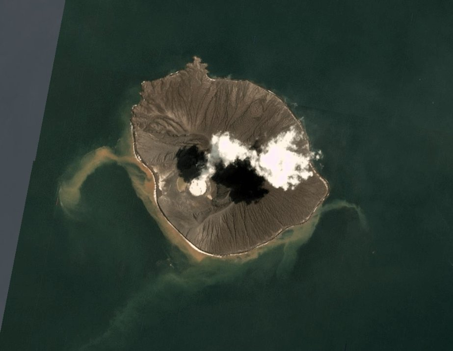
Indonesia , Anak Krakatau :
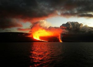
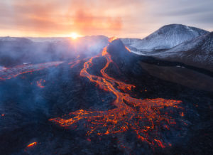
Level II activity level (Waspada) since March 25, 2019. The Anak Krakatau volcano (157 m above sea level) has experienced an increase in its volcanic activity since June 18, 2018, which was followed by a series eruptions in the period from September 2018 to February 2019. The last eruption occurred on April 10, 2020 with a strong column of eruption rising at most 500 meters above the summit.
Eruptions have been observed with a column height of 200 to 2000 m and gray / black smoke colors. Thanks to the CCTV camera, a continuous strombolian eruption was observed with an altitude of 200 to 500 m. In the absence of an eruption, a fine white smoke is observed at a height of 25 to 50 m. The weather is sunny / cloudy, the wind blows weakly towards the North and West.
According to seismographs, on April 11, 2020, it was recorded:
5 eruption earthquakes
8 explosion earthquakes.
Two non harmonic tremors
11 low frequency earthquake
Continuous tremor (Microtremor) amplitude 0.5 to 10 mm (dominant value 1 mm)
Recommendation: People / tourists are not allowed to approach the crater within a radius of 2 km.
VOLCANO OBSERVATORY NOTICE FOR AVIATION – VONA.
Issued: April 11 , 2020.
Volcano: Anak Krakatau (262000)
Current Aviation Colour Code: ORANGE
Previous Aviation Colour Code: orange
Source: Anak Krakatau Volcano Observatory
Notice Number: 2020KRA14
Volcano Location: S 06 deg 06 min 07 sec E 105 deg 25 min 23 sec
Area: Lampung, Indonesia
Summit Elevation: 502 FT (157 M)
Volcanic Activity Summary:
recorded eruption at 10:48 UTC (17:48 local)
Volcanic Cloud Height:
Best estimate of ash-cloud top is around 2102 FT (657 M) above sea level, may be higher than what can be observed clearly. Source of height data: ground observer.
Other Volcanic Cloud Information:
ash-cloud moving to north, volcanic ash gray thick 500 meters high from bottom crater
Remarks:
Eruption recorded on seismogram with maximum amplitude 40 mm and duration 40.38 second
Source : PVMBG , Magma Indonésie .
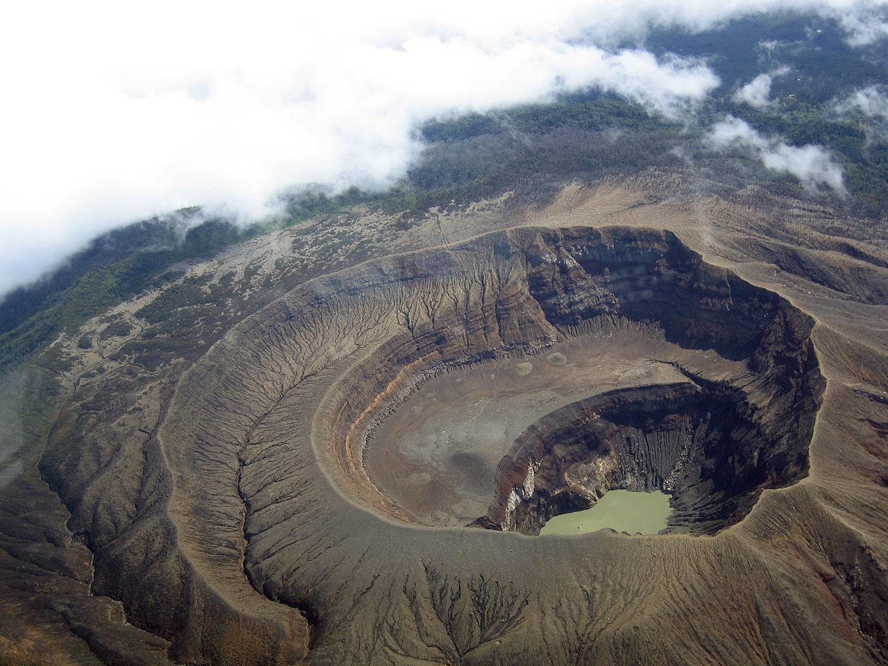
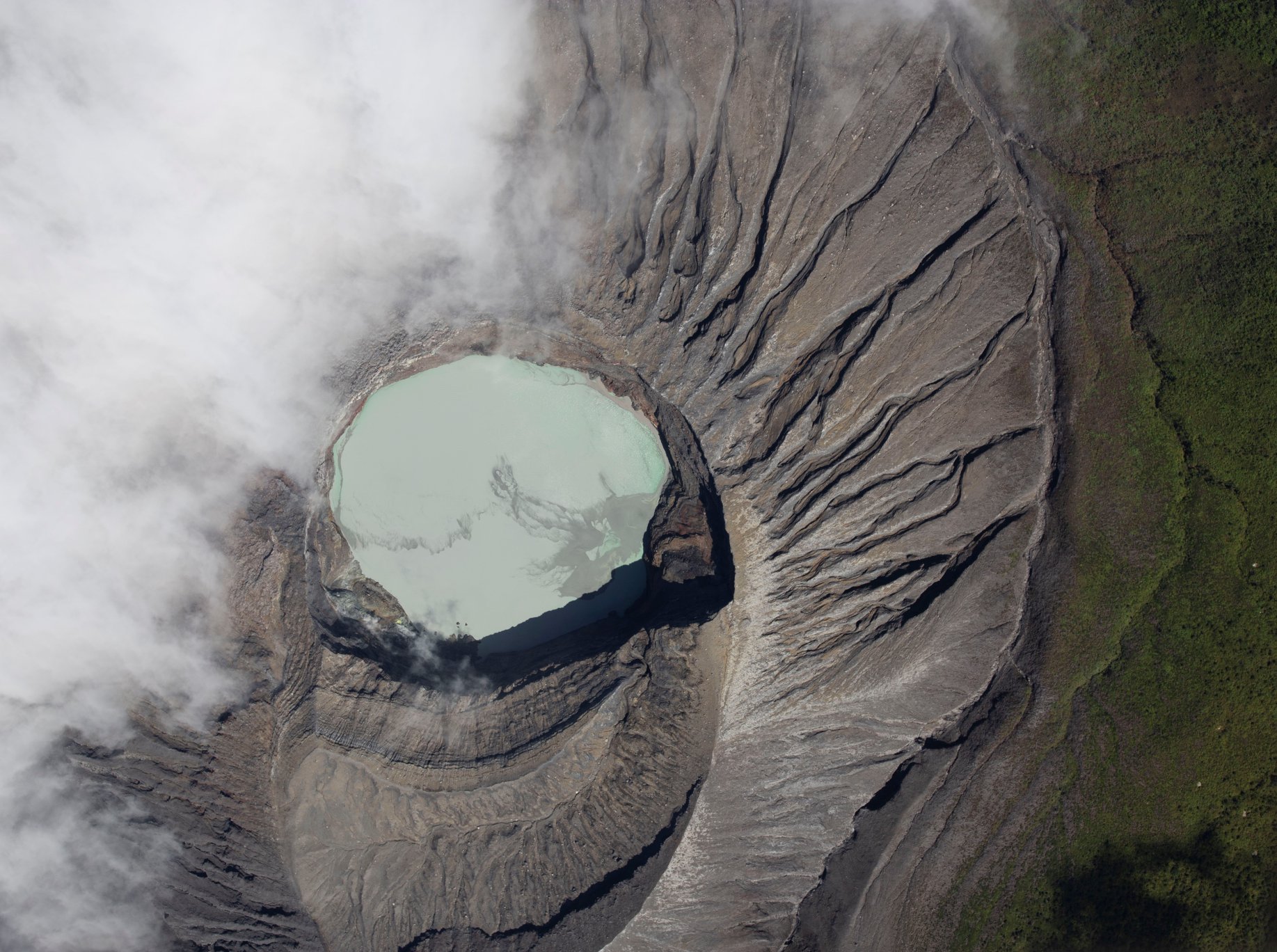
Photos : 31 March 2020 PlanetScope image , Info Pandeglang.
El Salvador , Santa Ana (Ilamatepec) :
Location: shared by the departments of Santa Ana and Sonsonate
Altitude: 2381 meters above sea level
Type of volcano: Stratovolcan
Type of activity: Vulcanienne- Strombolienne
Last eruption: October 1, 2005.
The seismic vibration of the volcano was maintained between 18 and 23 RSAM units on average per day, i.e. within a normal range.
As for sulfur dioxide (SO2) emissions, measured with DOAS equipment, they fluctuated between 171 and 414 tonnes per day, with an average of 215 tonnes per day, the threshold being 300 tonnes per day.
Park wardens monitoring the area have reported small plumes of gas coming out of the lagoon body of water. Despite the above parameters, the activity of the volcano remains stable and at its normal level, like all active volcanoes.
Source : Marn.
Photo : Volcano.USAF.C-130.3.
Costa Rica , Rincon de la Vieja :
Activity report of the Rincón de la Vieja volcano.
On April 11, 2020 at 00:33 local time, an eruption was recorded on the Rincón de la Vieja volcano, the height reached by the column is unknown due to the visibility conditions of the site.
Duration of the activity: 20 seconds (1/3 minute).
Ash falls reported: No report
Reported sulfur odor: No report
Comments: This is a small-scale hydrothermal explosion preceded by long-period type earthquakes (LP) linked to the transport of fluids (water, steam, gas and / or magma). The hydrothermal explosion was recorded by both the seismographs and the OVSICORI-UNA infrasound sensor system located near the active crater of Rincón. This explosion had enough energy to push the water and fine sediments out of the lake, most of which fell in the upper part of the volcano, around the active crater. This is demonstrated by images from the webcam located in Sensoria, 4 km north of the crater, and by the white / milky color of the waters of the Pénjamo river observed this morning by the neighbors of the volcano.
Source : Ovsicori / María Martínez Cruz.
Photo : RSN.
Kamchatka , Klyuchevskoy :
VOLCANO OBSERVATORY NOTICE FOR AVIATION (VONA).
Issued: April 11 , 2020
Volcano: Klyuchevskoy (CAVW #300260)
Current aviation colour code: ORANGE
Previous aviation colour code: orange
Source: KVERT
Notice Number: 2020-44
Volcano Location: N 56 deg 3 min E 160 deg 38 min
Area: Kamchatka, Russia
Summit Elevation: 15580 ft (4750 m)
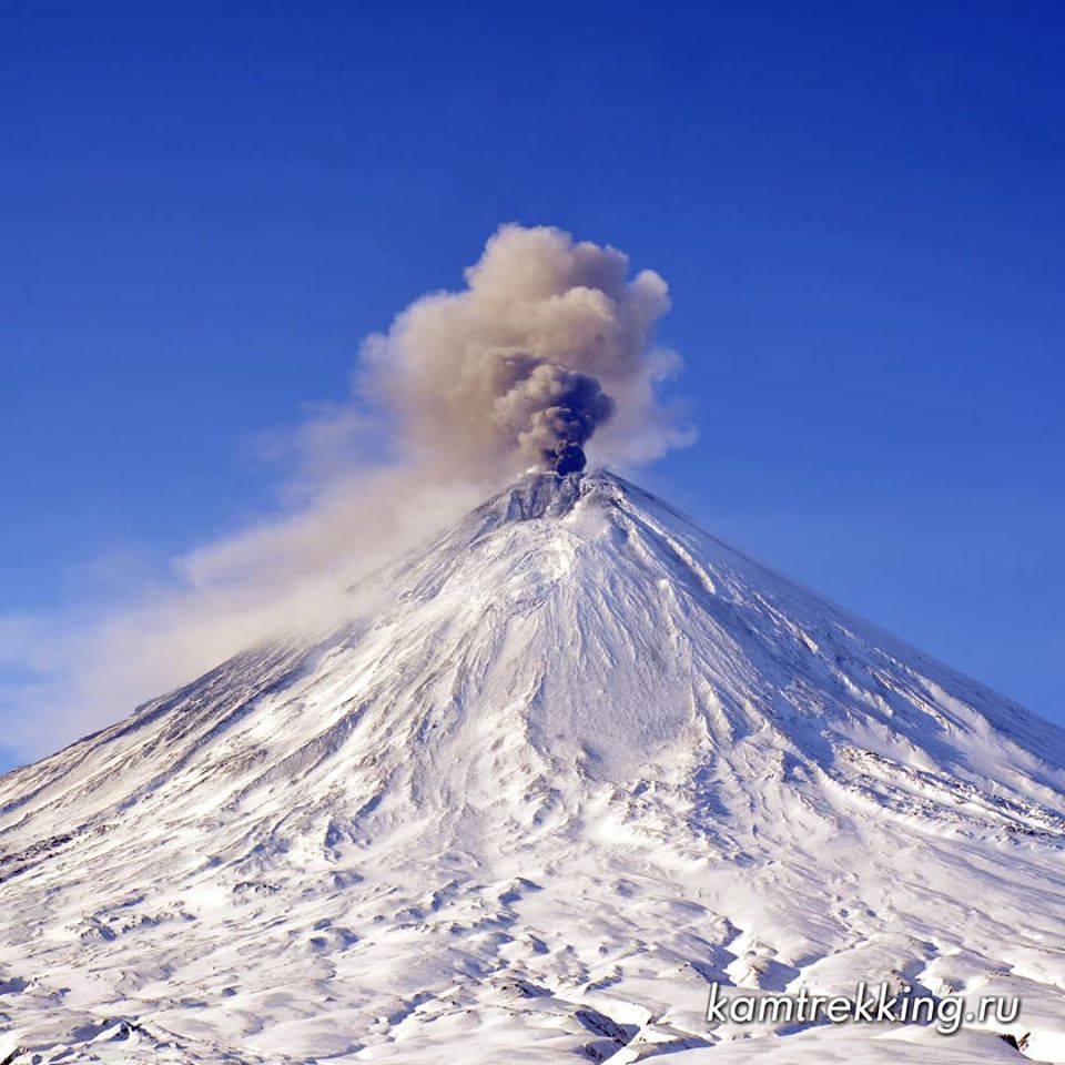
Volcanic Activity Summary:
A moderate explosive eruption of the Strombolian and sometimes Vulcanian types of the volcano continues. According to video and satellite data, a gas-steam plume containing some amount of ash is extending for 200 km to the south of the volcano.
A moderate explosive eruption of the volcano continues. Ash explosions up to 16,400-23,000 ft (5-7 km) a.s.l. could occur at any time. Ongoing activity could affect low-flying aircraft.
Volcanic cloud height:
18040-19680 ft (5500-6000 m) AMSL Time and method of ash plume/cloud height determination: 20200411/2320Z – Video data
Other volcanic cloud information:
Distance of ash plume/cloud of the volcano: 124 mi (200 km)
Direction of drift of ash plume/cloud of the volcano: S / azimuth 169 deg
Time and method of ash plume/cloud determination: 20200411/2250Z – Himawari-8
Source : Kvert .
Photo : Kamtrekking .
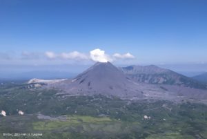
Indonesia , Karangetang :
Level III activity level (SIAGA). The Karangetang volcano (1784 m above sea level) has entered an eruption period since November 25, 2018. The last eruption occurred on November 29, 2019, causing an eruption column 100 meters above the summit . It is observed that the color of the smoke column is white.
The mountain is clear, the smoke from the crater is of low pressure, white in color, with a thick intensity and a height of 50 m above the top of the crater. The smoke from crater two is thick white, 50m high. The weather was sunny and cloudy, the wind blowing weakly towards the Southwest.
https://www.facebook.com/100041907843842/videos/239219044151689/
According to the seismographs of April 11, 2020, it was recorded:
1 emission earthquake
1 felt earthquake
Recommendation:
The community and visitors / tourists should not approach, climb or move around in the danger forecast area, which is a radius of 2.5 km around the summit of Kawah Dua (North crater) and from the main crater (South) and a sectoral expansion zone of the Kawah Dua to the North-West, to the North up to 4 km and from the main crater up to 3 km to the West.
The communities around G. Karangetang are recommended to prepare masks to cover the nose and mouth, in order to anticipate the potential danger of respiratory problems in the event of ash rain.
People living around the banks of rivers from the summit of Mount Karangetang must increase their preparedness for the potential threat of lahars and flash floods that may reach the coast.
Source : PVMBG.