January 30 , 2020 .
Philippines , Taal , ( Exclusive photos / 80 jours voyages ) :
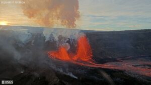
TAAL VOLCANO BULLETIN: 30 January 2020 8:00 A.M.
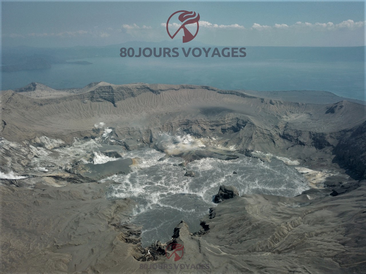
Activity in the Main Crater in the past 24 hours has been characterized by weak emission of white to dirty white steam-laden plumes 300 – 500 meters tall that drifted southwest. Sulfur dioxide (SO2) emission was below instrumental detection.
Exclusive: Taal crater drone video taken today 29/01/2020 by Sylvain Chermette.
The fallout from the ashes is of course visible as well as a lot of damage in the surroundings, outside and inside the houses, with many imposing cracks in the walls..
The Philippine Seismic Network (PSN) plotted a total of seven hundred sixty-three (763) volcanic earthquakes since 1:00 PM, January 12, 2020. One hundred seventy-seven (177) of these registered at magnitudes M1.2-M4.1 and were felt at Intensities I-V. Since 5:00 AM on January 29, 2020 until 5:00 AM today, there were seven (7) volcanic earthquakes plotted that registered at magnitudes M1.7-M2.5 with no felt event.
For the past 24 hours, the Taal Volcano Network, which can record small earthquakes undetectable by the PSN, recorded one hundred thirty-seven (137) volcanic earthquakes including two (2) low-frequency events and one (1) harmonic tremor that lasted for 97 seconds. These earthquakes signify magmatic activity beneath the Taal edifice that could lead to eruptive activity at the Main Crater.
From our correspondent on the spot: people came back to clear the houses of the ashes, to take care of the animals, to repair the significant damage due to the earthquakes. Access to the island is prohibited and monitored by the army.

Alert Level 3 is maintained over Taal Volcano. DOST-PHIVOLCS reminds the public that sudden steam-driven and even weak phreatomagmatic explosions, volcanic earthquakes, ashfall, and lethal volcanic gas expulsions can still occur and threaten areas within Taal Volcano Island and nearby lakeshores. DOST-PHIVOLCS recommends that entry into the Taal Volcano Island as well as into areas over Taal Lake and communities west of the island within a seven (7) km radius from the Main Crater must be strictly prohibited. Local government units are advised to assess areas outside the seven-kilometer radius for damages and road accessibilities and to strengthen preparedness, contingency and communication measures in case of renewed unrest.
People are also advised to observe precautions due to ground displacement across fissures, frequent ashfall and minor earthquakes. Communities beside active river channels particularly where ash from the main eruption phase has been thickly deposited should increase vigilance when there is heavy and prolonged rainfall since the ash can be washed away and form lahars along the channels. Civil aviation authorities must advise pilots to avoid flying close to the volcano as airborne ash and ballistic fragments from sudden explosions and wind-remobilized ash may pose hazards to aircrafts.
DOST-PHIVOLCS is closely monitoring Taal Volcano’s activity and any new significant development will be immediately communicated to all stakeholders.
Source : Phivolcs , Sylvain Chermette / 80 Jours / Voyages .
Photos and vidéo : Sylvain Chermette / 80 Jours / Voyages . https://80joursvoyages.com/
Japan , Kuchinoerabujima :
30.443°N, 130.217°E
Elevation 657 m
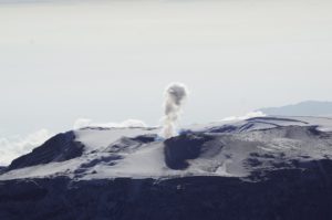
Very small eruptive events recorded at Kuchinoerabujima on 20, 23, and 24 January produced grayish-white plumes that rose 500 m above the crater rim. Ashfall 2 km NE of the crater was confirmed during aerial observations on 23 January. The number of volcanic earthquakes increased during 25-26 January. An eruptive event was recorded at 0148 on 27 January, though weather clouds prevented visual confirmation; volcanic tremor, changes in tilt data, and infrasound signals accompanied the event. Sulfur dioxide gas emissions were 200-1,000 tons per day during 20-27 January; JMA characterized emissions of 600-1,000 tons per day as high.
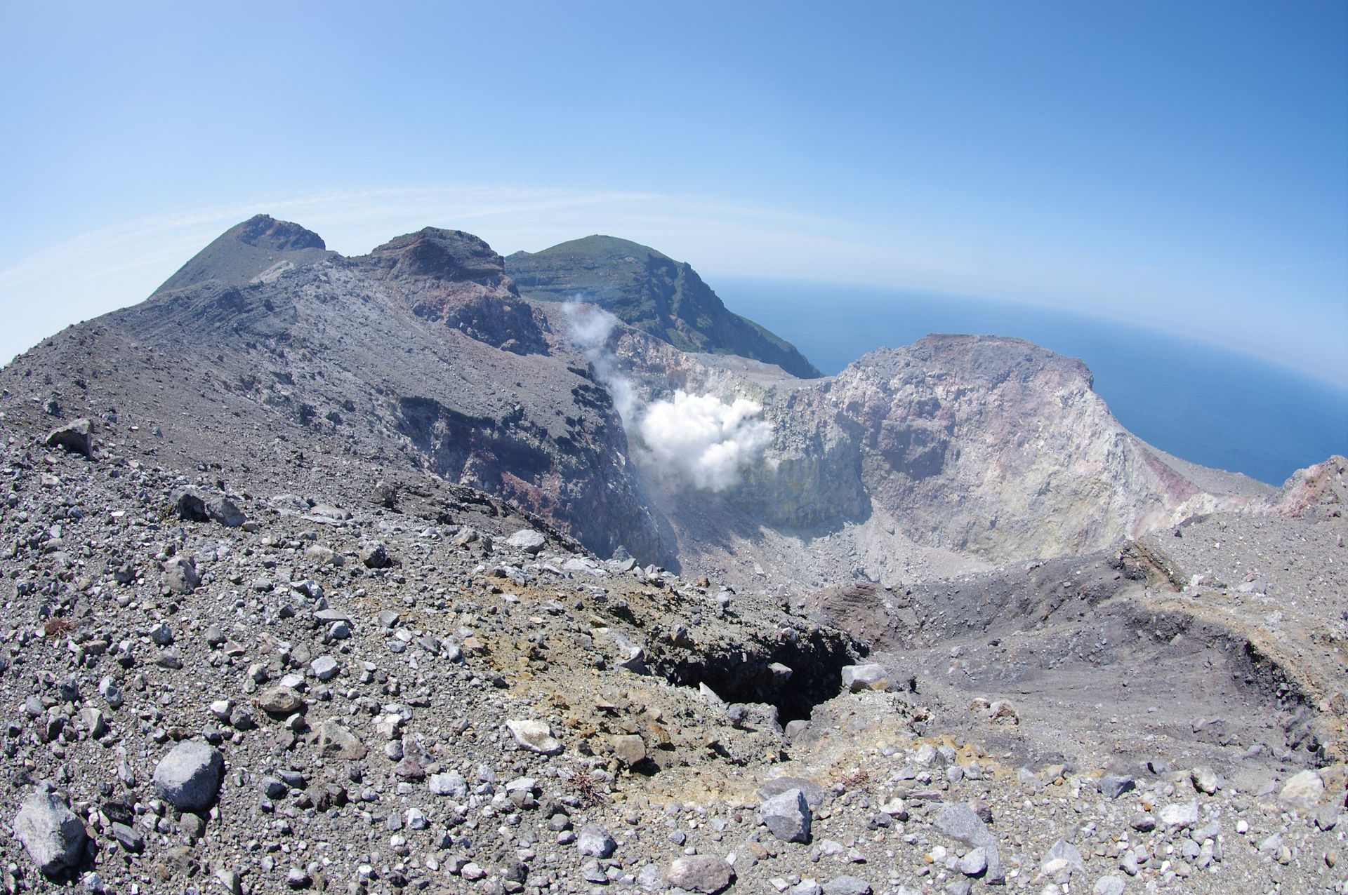
Shindake crater .
A group of young stratovolcanoes forms the eastern end of the irregularly shaped island of Kuchinoerabujima in the northern Ryukyu Islands, 15 km W of Yakushima. The Furudake, Shindake, and Noikeyama cones were erupted from south to north, respectively, forming a composite cone with multiple craters. The youngest cone, centrally-located Shindake, formed after the NW side of Furudake was breached by an explosion. All historical eruptions have occurred from Shindake, although a lava flow from the S flank of Furudake that reached the coast has a very fresh morphology. Frequent explosive eruptions have taken place from Shindake since 1840; the largest of these was in December 1933. Several villages on the 4 x 12 km island are located within a few kilometers of the active crater and have suffered damage from eruptions.
Source : GVP , JMA .
Photo : Par tsuda — Flickr: Kuchino-erabu island (volcano), CC BY-SA 2.0, https://commons.wikimedia.org/w/index.php?curid=30876298.
Kamchatka , Klyuchevskoy :
VOLCANO OBSERVATORY NOTICE FOR AVIATION (VONA).
Issued: January 30 , 2020
Volcano: Klyuchevskoy (CAVW #300260)
Current aviation colour code: ORANGE
Previous aviation colour code: orange
Source: KVERT
Notice Number: 2020-14
Volcano Location: N 56 deg 3 min E 160 deg 38 min
Area: Kamchatka, Russia
Summit Elevation: 15580 ft (4750 m)

Volcanic Activity Summary:
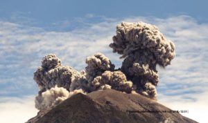
A moderate eruptive activity of the volcano continues. According to video data, a gas-steam with some amount of ash activity of the volcano continues. An ash plume extended to the east of the volcano.
This activity continues. Ash explosions up to 16,400-23,000 ft (5-7 km) a.s.l. could occur at any time. Ongoing activity could affect low-flying aircraft.
Volcanic cloud height:
16400-18040 ft (5000-5500 m) AMSL Time and method of ash plume/cloud height determination: 20200130/0228Z – Video data
Other volcanic cloud information:
Distance of ash plume/cloud of the volcano: 29 mi (46 km)
Direction of drift of ash plume/cloud of the volcano: E / azimuth 93 deg
Time and method of ash plume/cloud determination: 20200130/0137Z – MODIS TERRA (31m32)
Source : Kvert.
Photo : Yu. Demyanchuk, IVS FEB RAS, KVERT ( 2017).
Colombia , Galeras :
Galeras Volcano Weekly Bulletin
The activity of the volcano continues at the level: YELLOW LEVEL ■ (III): CHANGES IN THE BEHAVIOR OF VOLCANIC ACTIVITY.
Following the activity of VOLCÁN GALERAS, the COLOMBIAN GEOLOGICAL SERVICE (SGC) reports that:
For the period from January 21 to 27, 2020, the seismic activity maintained low levels, characteristic of the last years on the Galeras. Seismicity was mainly associated with the processes of rock fracture inside the volcanic building, in two sources. The first towards the western sector of the volcano, at a distance of approximately 6 km from the active crater and at an average depth of 7.5 km from its summit (4200 m above sea level); the most energetic event from this source was recorded on January 27 at 4:44 am (local time), with a magnitude of 2.0 on the Richter scale. The second source was located towards the northeast of the volcano, at an average distance of 13.5 km from the crater and at a depth of about 8 km below the summit. The most energetic event was recorded on January 27 at 18 h 52 (local time), with a magnitude of M 3.5 on the Richter scale. This earthquake was reported to be felt by residents of the municipalities of Pasto, Nariño, La Florida, Buesaco and Chachagüi.

Favorable climatic conditions made it possible to observe the summit of the volcano with degassing processes from various sectors of the active cone. Gas emissions were characterized by low height, low pressure and a white color. The other geophysical and geochemical monitoring parameters of the Galeras volcano did not show any significant variation.
The COLOMBIAN GEOLOGICAL SERVICE remains attentive to the evolution of the volcanic phenomenon and will continue to report the changes observed in due course.
Source : SGC.
Photo : capra.
Italy , Stromboli :
Weekly bulletin from 20/01/2020 to 26/01/2020 (date of issue 28/01/2020).
SUMMARY OF ACTIVITY STATUS
In light of the monitoring data, it is highlighted:
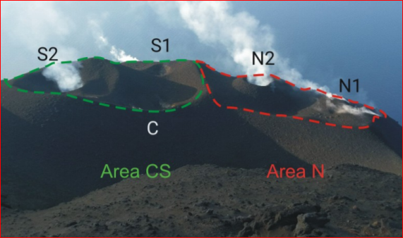
1) VOLCANOLOGICAL OBSERVATIONS: During this period, a normal strombolian type explosive activity was observed accompanied by degassing and splashing activities. The hourly frequency of explosions fluctuated between medium to high values (15-20 events / h). The intensity of the explosions was mainly medium-low in the area of the North crater and medium-high in the area of the Center-South crater.
2) SEISMOLOGY: The seismological parameters do not show significant variations.
4) DEFORMATIONS: There are no significant variations. There is a modest variation in the N275E component of the TDF tilt.
5) GEOCHEMISTRY: The flow of SO2 is at an average level. The CO2 / SO2 ratio was established at a medium / low value. There is no update from last week regarding the isotopic ratio of dissolved helium in the aquifer.
VOLCANOLOGICAL OBSERVATIONS
The analysis of the images recorded by the cameras placed at an altitude of 400 m, at an altitude of 190 m and at Punta dei Corvi made it possible to characterize the eruptive activity of Stromboli. During the reporting period, the explosive activity was mainly produced by at least 3 (three) eruptive vents located in the area of the North crater and by at least 3 (three) eruptive vents located in the area of the Center-South crater . All the vents are located inside the depression which occupies the crater terrace.
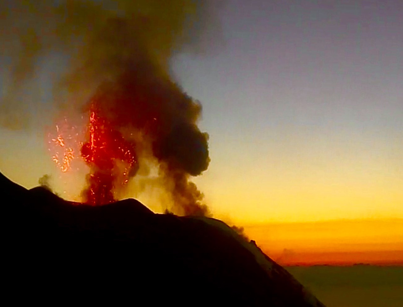
In the North zone, the explosions were mainly low (less than 80 m high) and medium (less than 150 m high), sometimes high (greater than 150 m high) emitting coarse materials (lapilli and bombs). In numerous explosions, the fallout covered the outer slopes of the area overlooking the Sciara del Fuoco and some blocks rolled a few hundred meters before the mesa in place along the Sciara. In addition, occasional splashes were observed at the southern mouth of the crater area N. The average frequency of explosions in the northern area varied between 5 and 8 events / h. The explosive activity of the Center-South zone produced explosions of coarse materials mixed with fines, of medium intensity (less than 150 m high) and high (the products reached 200 m high). In some explosions, the products fell in the upper part of the Sciara. The frequency of explosions in the Center-South zone varied between 9 and 14 events / h.
Source : INGV.
Read the whole article : file:///C:/Users/Utilisateur/AppData/Local/Packages/Microsoft.MicrosoftEdge_8wekyb3d8bbwe/TempState/Downloads/BollettinoStromboli20200128%20(1).pdf
Photo : Webcam.