December 30 , 2019 .
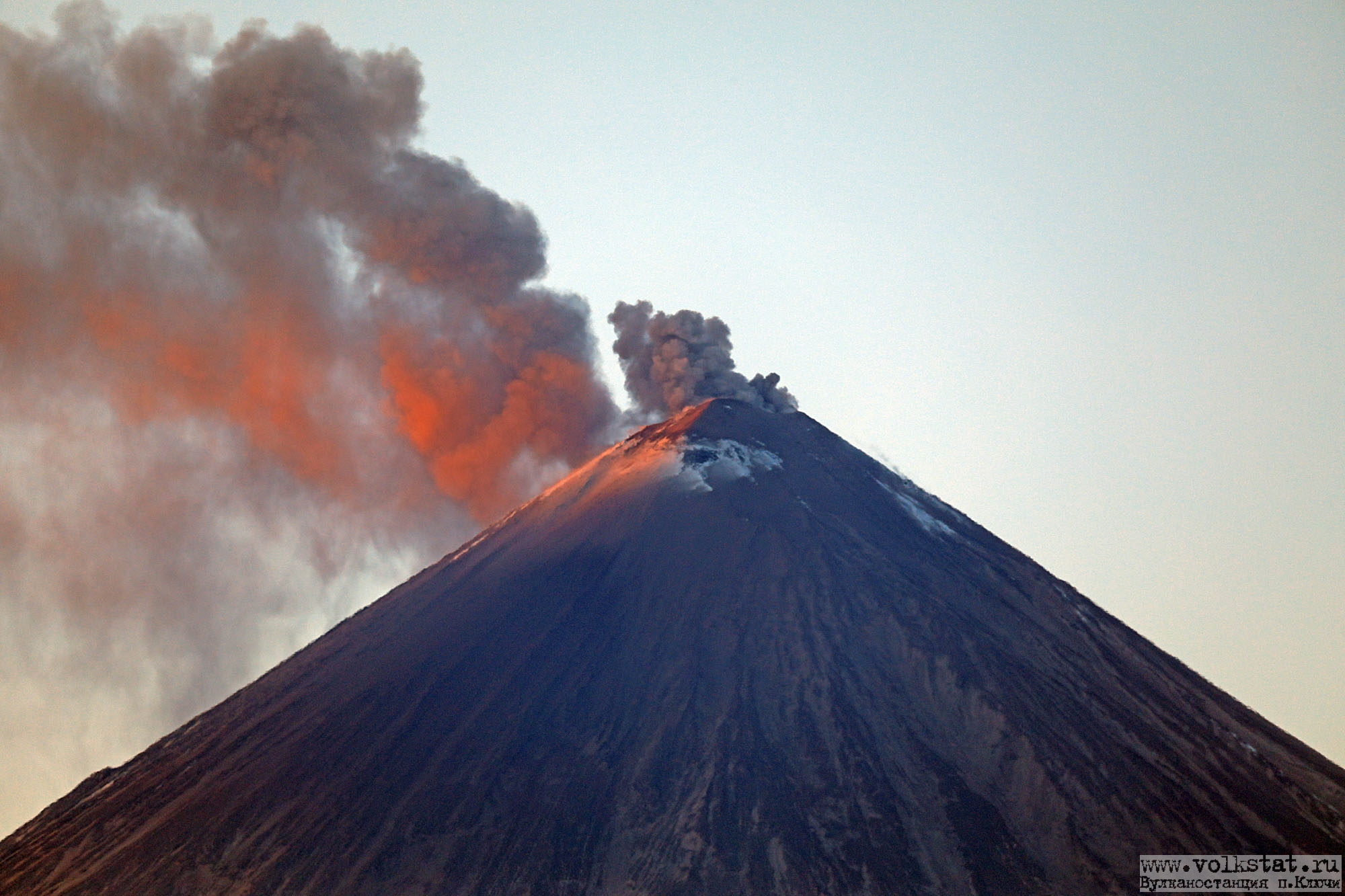
Kamchatka , Klyuchevskoy :
VOLCANO OBSERVATORY NOTICE FOR AVIATION (VONA).
Issued: December 30 , 2019.
Volcano: Klyuchevskoy (CAVW #300260)
Current aviation colour code: ORANGE
Previous aviation colour code: orange
Source: KVERT
Notice Number: 2019-185
Volcano Location: N 56 deg 3 min E 160 deg 38 min
Area: Kamchatka, Russia
Summit Elevation: 15580 ft (4750 m)
Volcanic Activity Summary:
A moderate activity of the volcano continues. Ash plume extend to the east-south-east of the volcano.
A moderate activity of the volcano continues. Ash explosions up to 16,400-23,000 ft (5-7 km) a.s.l. could occur at any time. Ongoing activity could affect low-flying aircraft.
Volcanic cloud height:
16400-18040 ft (5000-5500 m) AMSL Time and method of ash plume/cloud height determination: 20191230/0150Z – Video data
Other volcanic cloud information:
Distance of ash plume/cloud of the volcano: 81 mi (130 km)
Direction of drift of ash plume/cloud of the volcano: ESE / azimuth 108 deg
Time and method of ash plume/cloud determination: 20191230/0200Z – Himawari-8
Source : Kvert.
Photo : Volkstat ru.
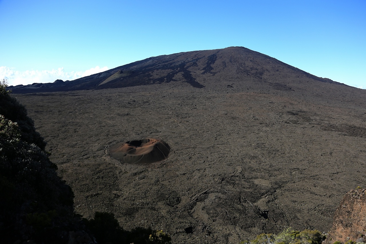
La Réunion , Piton de la Fournaise :
Activity bulletin for Monday, December 30, 2019 at 10:15 a.m. (local time)
Alert level: Vigilance
For the past week, inflation (swelling) of the base and top of the Piton de la Fournaise building has been observed again by the OVPF deformation network (Figure 1). This resumption of building inflation is synonymous with the pressurization of a deep source located under the summit craters (Figure 2).
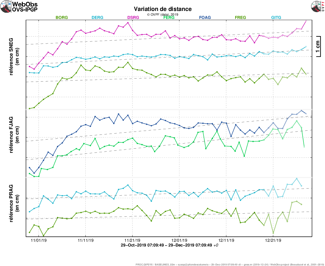
Figure 1: Illustration of the deformation over the last two months. Here are shown the variations in distance between two GPS receivers crossing the Piton de la Fournaise building, at the top (reference SNEG; top), at the base of the terminal cone (reference FJAG; in the middle) and in the far field (reference PRAG; below). An increase is synonymous with elongation and therefore swelling of the volcano; conversely, a decrease is synonymous with contraction and therefore deflation of the volcano. (© OVPF-IPGP)

Figure 2: Map of horizontal soil movements recorded in the past two weeks. (© OVPF-IPGP)
In parallel, the CO2 concentrations in the far field soil (Plaine des Cafres and Plaine des Palmistes sectors) are still increasing since the end of the eruption of October 25-27 (Figure 3). These CO2 concentrations are in agreement with a deep rise in magma.
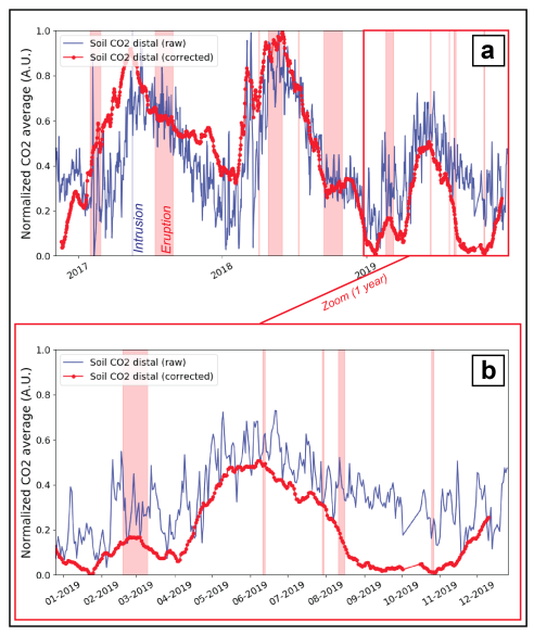
Figure 3: Comparison between normalized means of raw CO2 flux data in the soil (in blue) and corrected (in red), recorded at stations located in the far field (a) since October 2016 (date of installation of the last station) and (b) over a year. Eruptive periods are shown in red. (© OVPF-IPGP)
These two parameters (CO2 concentration and resumption of inflation) are in agreement with a pressurization of the surface magmatic reservoir (located between 1.5 and 2.5 km deep) due to its replenishment by magmatic fluids more deep.
For the moment the seismicity does not show a significant increase: only 9 superficial volcano-tectonic earthquakes were recorded in the last week (between 23 and 29 December).
Note that this process of recharging the surface reservoir can last several days to several weeks before the reservoir roof weakens and ruptures, thus giving rise to an injection of magma towards the surface and an eruption, and can also stop without giving rise to an eruption in the short term.
Source : OVPF.
Read the article : http://www.ipgp.fr/fr/ovpf/bulletin-dactivite-lundi-30-decembre-2019-a-10h15-heure-locale
Photo : B Duyck.
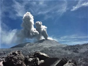
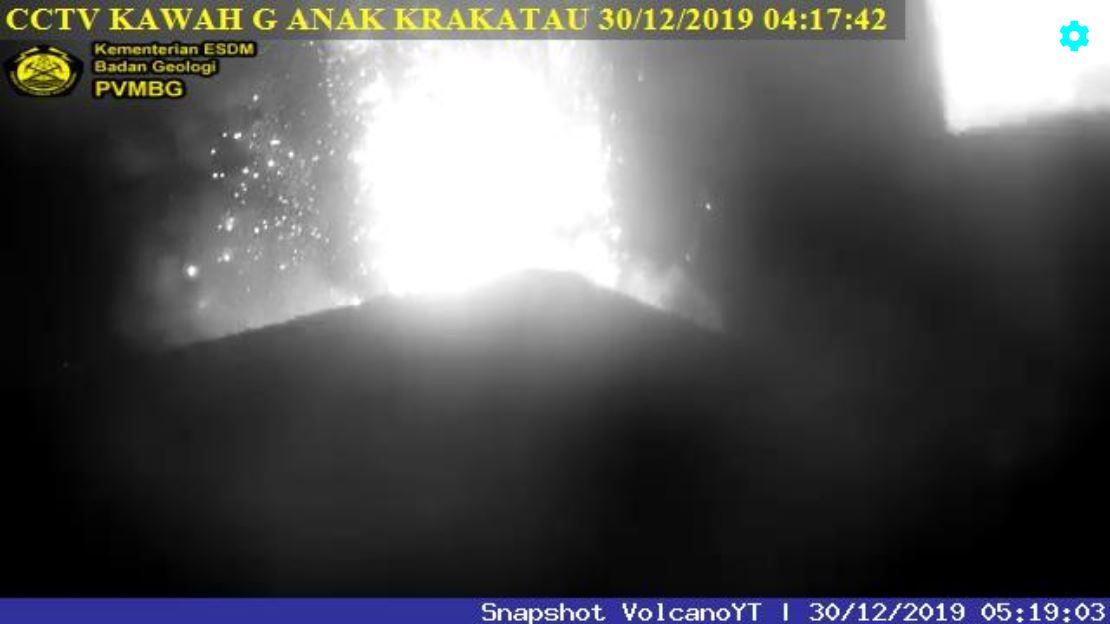
Indonesia , Anak Krakatau :
VOLCANO OBSERVATORY NOTICE FOR AVIATION – VONA.
Issued: December 30 , 2019 .
Volcano: Anak Krakatau (262000)
Current Aviation Colour Code: ORANGE
Previous Aviation Colour Code: orange
Source: Anak Krakatau Volcano Observatory
Notice Number: 2019KRA201
Volcano Location: S 06 deg 06 min 07 sec E 105 deg 25 min 23 sec
Area: Lampung, Indonesia
Summit Elevation: 502 FT (157 M)
Volcanic Activity Summary:
Eruption with ash clouds at 06h35 UTC (13h35 local time).
Volcanic Cloud Height:
Best estimate of ash-cloud top is around 3702 FT (1157 M) above sea level, may be higher than what can be observed clearly. Source of height data: ground observer.
Other Volcanic Cloud Information:
Ash-cloud moving to south.
Remarks:
Eruption recorded on seismogram with maximum amplitude 44 mm and duration 137 second.
Level of activity at level II (Waspada), since March 25, 2019. The Anak Krakatau (157 m above sea level) has experienced an increase in its volcanic activity since June 18, 2018, which was followed by a series of eruptions in the period from September 2018 to February 2019. The last eruption occurred on December 29, 2019, with a height of the eruption column of 200 m from the bottom of the crater. The color of the gray column was observed to be white / black.
Volcano covered with fog. Thanks to video surveillance, we observed the main crater with white / gray smoke, of fine to thick intensity, at a height of about 25-200 meters above the summit. The weather is sunny to cloudy, the wind is weak in the east. The temperature is around 24.9-30 ° C. Humidity 47 – 54%.
According to the seismographs of December 29, 2019, it was recorded:
1 eruption earthquake
11 low frequency earthquakes
Continuous tremor, amplitude 5-55 mm (dominant value 23 mm)
Recommendation:
The public / tourists are not allowed to approach the crater within a radius of 2 km.
Source : Magma Indonésie , PVMBG.
Photos : PVMBG , Andrey Nikiforov / Volcanodiscovery .
Guatemala , Pacaya :
Type of activity: Strombolian.
Morphology: composite stratovolcano
Location: 14 ° 22’50’ Latitude N; 90 ° 36’00˝ Longitude W
Height: 2552msnm
Atmospheric conditions: Clear
Wind: North at 5 km / h
Precipitation: 0.00 mm.
https://www.facebook.com/B.castillo310/videos/1498689123620716/
Activity:
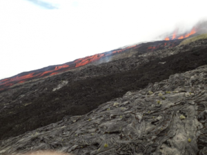
A white and blue degassing plume rises to a height of 2800 meters above sea level and disperses over 500 m to the North. At night and early in the morning we observe the reflection of the incandescence of the lava flows of a length of 300 towards the Southwest, Strombolian explosions are generated which expel incandescent materials from 15 to 75 m above the crater MacKenney, the seismic stations record constant tremors associated with the rise of magma and gases.
Source : Insivumeh .
Vidéo : Billy Castillo / Facebook.