December 17 , 2019.
New Zealand , White Island :
Volcanic Alert BulletinWI – 2019/25 . Tue Dec 17 2019 11:45 AM; White Island Volcano
Volcanic Alert Level remains at 2
Aviation Colour Code remains at Orange
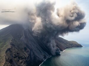
The volcanic tremor at Whakaari/White Island continues at a low level. No eruptions have occurred since Monday 9 December and further eruptions are unlikely in the next 24 hours. The Volcanic Alert Level remains at Level 2.
Since the eruption on Monday, December 9th, there has been no further significant eruptive activity and the level of volcanic tremor remains low.
The expert judgement made this morning calculated the likelihood of another eruption within the next 24 hours at 25 – 40%. This means another eruption is unlikely over the next 24 hours. Following this confirmed likelihood, the distances for GNS Science staff access zones have remained the same. This will be reviewed tomorrow.
From aerial observations on Saturday and Sunday (14 and 15 December) at least three open vents are seen within a 100-metre square area. One is pulsing transparent high temperature gas, which indicates magma is located not far below the surface. This open hot vent is responsible for the glow still being seen in night time camera images. There are also extensive steam and gas emissions from other active vents in the main vent area.
An explosive eruption from the main vent area can still occur with no precursory activity, especially if there is a collapse of unstable material around one of the vents, or if the gas emission decreases allowing groundwater to enter the vent.
Sudden steam/gas eruptions from other active vents are also possible.
As the wind remains northerly today, a sulphur-like gas smell might be noticed in the Ōpōtiki to Whakatāne area, as occurred on many occasions during the 1976 to 2000 eruptive period. People may feel this gas as a slight irritant on skin or eyes.
Should any explosive activity produce an ash cloud there is an extremely low likelihood of ash affecting the mainland in the next 24 hours. This ash would be a nuisance only, unless someone has a respiratory disorder. Check with your GP if you are concerned.
Some monitoring equipment remains partially buried under ash, but rain washing has cleared some off and helped improve solar power charging. We still receive data from the remaining equipment, which allows us to continue monitoring the volcano. Both seismic stations on the island are fully operational and are providing us with round the clock data.
We will continue to provide 24-hour estimates of eruption likelihood to support operations.
GNS Science and our National Geohazards Monitoring Centre continue to closely monitor Whakaari/White Island for further signs of activity.
Source : Geonet / Michael Rosenberg, Duty Volcanologist.
Photo : George Novak.
Japan , Nishinoshima :
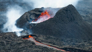
Japanese authorities have extended the danger zone surrounding the active volcano of Nishinoshima, an isolated island in the Pacific, due to the increased lava flow.
Nishinoshima is located approximately 130 kilometers west of Chichijima in the Ogasawara Islands. The volcano erupted in 2013.
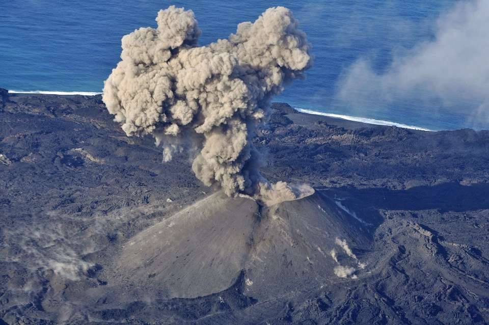
After the resumption of volcanic activity in early December, the Meteorological Agency issued a warning to the passage of ships.
The Japanese Coast Guard conducted an aerial observation of the volcano on Sunday. Officials say they have spotted lava flowing from a new crater. This one has reached the ocean.
Meteorological Agency officials say that a larger volume of lava can travel on the northern slopes of the volcano. The agency updated the warning on Monday. She now states that people should not approach within 2.5 kilometers of the crater.
Agency officials and the coast guard also issued a navigation warning for the waters around Nishinoshima, warning of possible rockfalls and lava flows.
Source : www3.nhk.or.jp
Photo : Archives gardes cotes japonais .
Peru , Sabancaya :
Analysis period: December 9 to 15, 2019 Arequipa, December 16, 2019
Alert level: ORANGE
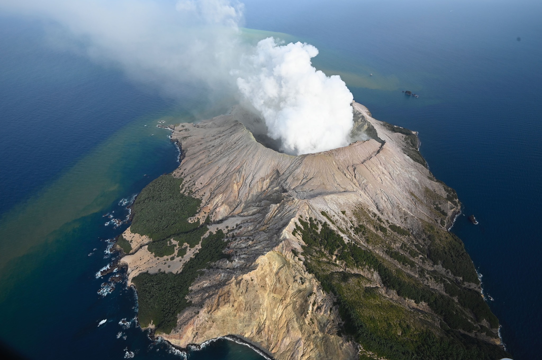
The Peruvian Geophysical Institute (IGP) reports that the eruptive activity of the Sabancaya volcano has been maintained at moderate levels; that is, with the continuous recording of moderate explosions and the resulting ash emissions. Consequently, for the following days, no significant change in activity is expected.
Analysis of the records obtained from the seismic network of the Sabancaya volcano in the period from December 9 to 15, 2019 has identified the occurrence of around 1,070 earthquakes of volcanic origin, the highest percentage of which is associated with the circulation of fluids (magma, gas, etc.) inside the volcano. During this period, there were on average 23 daily explosions of medium to low intensity.
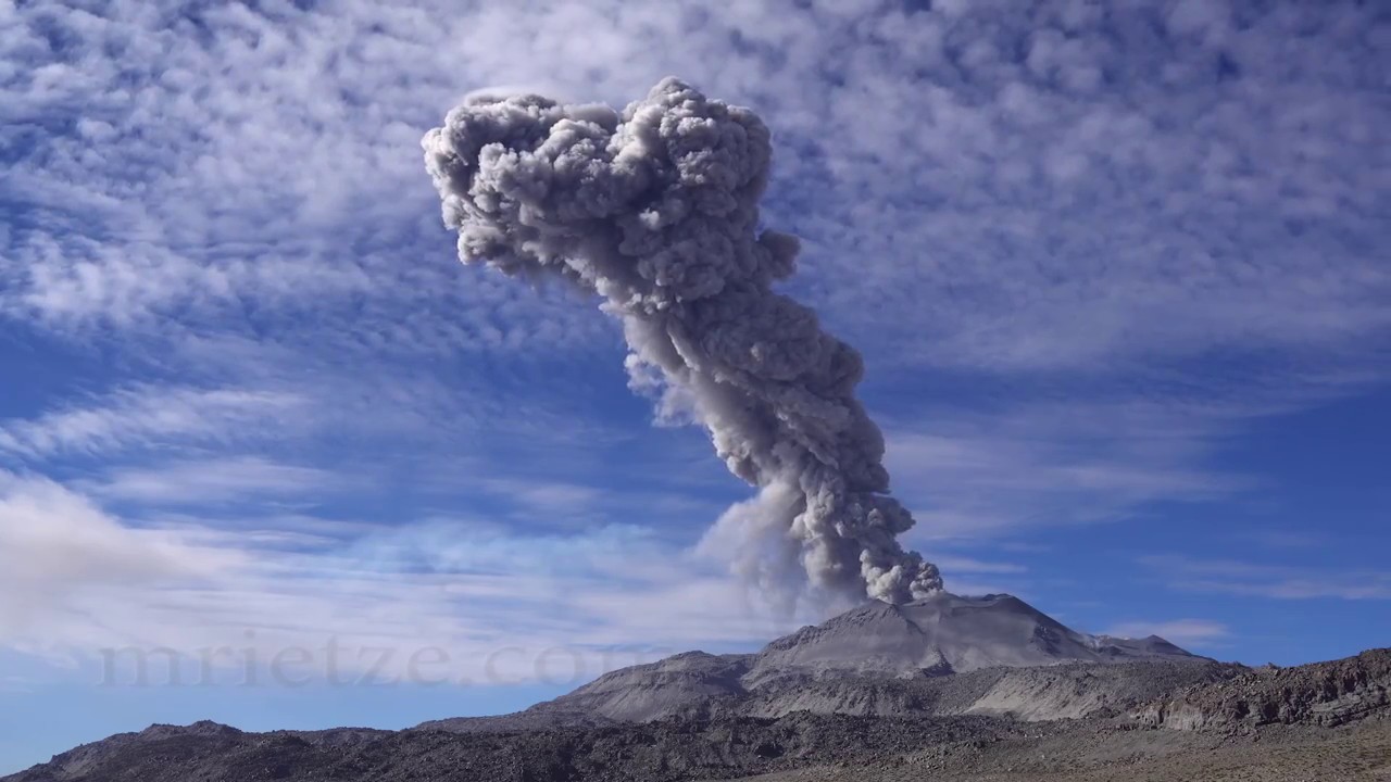
The monitoring of the deformation of the volcanic structure, using GNSS data (processed with fast orbits), does not present any significant anomalies. Visual surveillance, using surveillance cameras, made it possible to identify the presence of columns of gas and ash up to 3.3 km high above the summit of the volcano, which dispersed in the sectors South-West, West and North-West of Sabancaya. In addition, between December 10 and 11, the expulsion of rock fragments from the dome at distances close to 3 km from the crater was recorded. Satellite surveillance has made it possible to identify, on the volcano, the presence of 7 thermal anomalies of values between 1 MW and 29 MW, associated with the presence of a lava dome in the crater of the volcano of approximately 240 m of diameter.
Source : IGP.
Photo : Martin Rietze.
Kamchatka , Bezymyannyi :
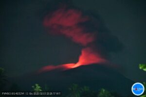
The Bezymyannyi volcano in Kamchatka is preparing for an eruption A powerful eruption of the Bezymyannyi volcano in Kamchatka is possible at any time of the week.
This was reported in the press service of the Institute of Volcanology and Seismology FEB RAS. – According to daily monitoring: The activity of the Bezymyannyi volcano began to increase from the first days of December. A gradual increase in the temperature of the thermal anomaly was noted in the region of the summit of the volcano, as well as an increase in its vapor-gas activity. On December 11, a small lava flow was discovered on a satellite image on the western slope of the lava dome of Bezymyanny. Over the past two days, the temperature of the anomaly has risen significantly, which could point to a possible explosive eruption of the volcano, « said Olga Girina, director of the KVERT Institute of Volcanology and Seismology.
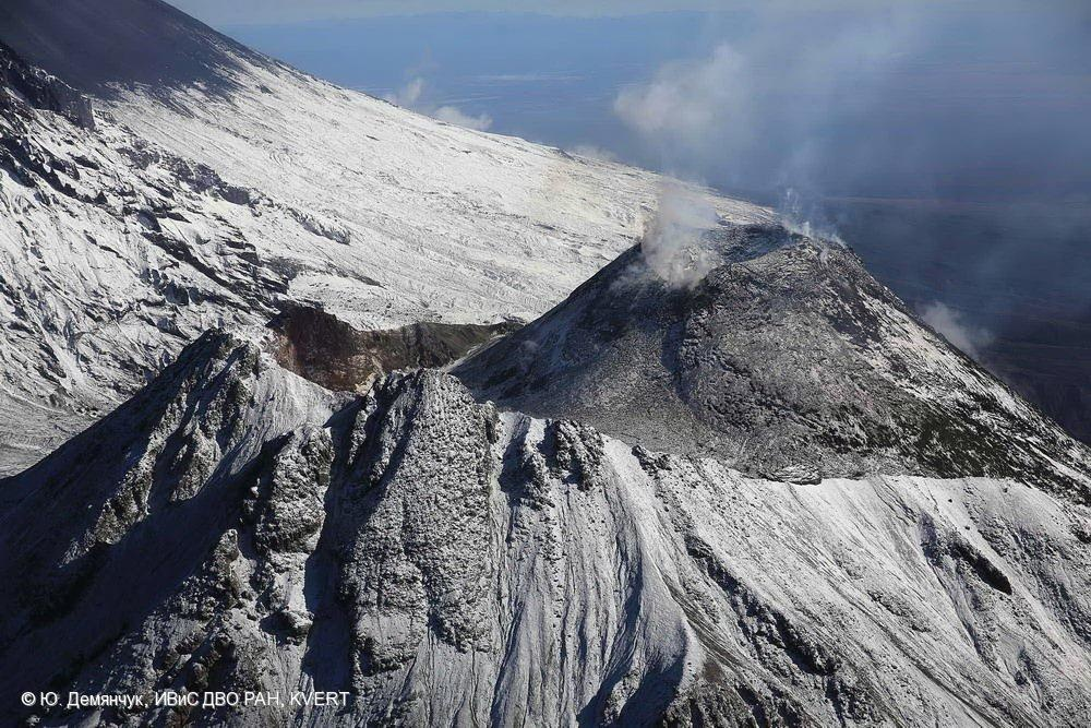
She added that the Bezymyanny aviation danger code had changed from yellow to orange. This week, an eruption with an ash discharge from 10 to 15 km above sea level can occur. It will be dangerous for international and local airlines. Ash falls could be possible in the villages of Kozyrevsk, Maiskoye, Klyuchi, Ust-Kamchatsk. It was reminded by the institute that the Bezymyannyi volcano is located in the central part of the group of Klyuchevsky volcanoes 40 km from the village of Klyuchi in the Ust-Kamchatsky region and 350 km from Petropavlovsk-Kamchatsky. Its height reaches 3 km. The previous powerful explosive eruption occurred on March 15, 2019.
Information from the Institute of Volcanology and Seismology: Thanks to the Bezymyanny, the volcanology service appeared in the USSR: the catastrophic eruption of the volcano on March 30, 1956 became the first predicted reliably. The ash cloud had reached a height of over 35 km, and the mudslides passed 90 km and dammed the Kamchatka River. The volume of eruption material ejected and moved was approximately three cubic kilometers.
Source : ia41.ru
Photo: Yuri Demyanchuk.
Read the article : http://ia41.ru/2019/12/16/vulkan-bezymyannyj-na-kamchatke-gotovitsya-k-izverzheniyu/?fbclid=IwAR17zWhrxfVc_NzCs-e6U_t_cXIyxnaZzd7s-1m9bC3yY8qHCPXa0TAD8D8
Peru , Ubinas :
Analysis period: December 9 to 15, 2019 Arequipa, December 16, 2019
Alert level: ORANGE
The Geophysical Institute of Peru (IGP) reports that the eruptive activity of the Ubinas volcano remains at low levels. To date, the energy of earthquakes associated with the rise of magma to the surface has considerably decreased. There are low and sporadic emissions of bluish gases (of magmatic origin) and water vapor, observed by means of surveillance cameras. According to this scenario, the possibility of volcanic explosions and / or ash emissions is low.
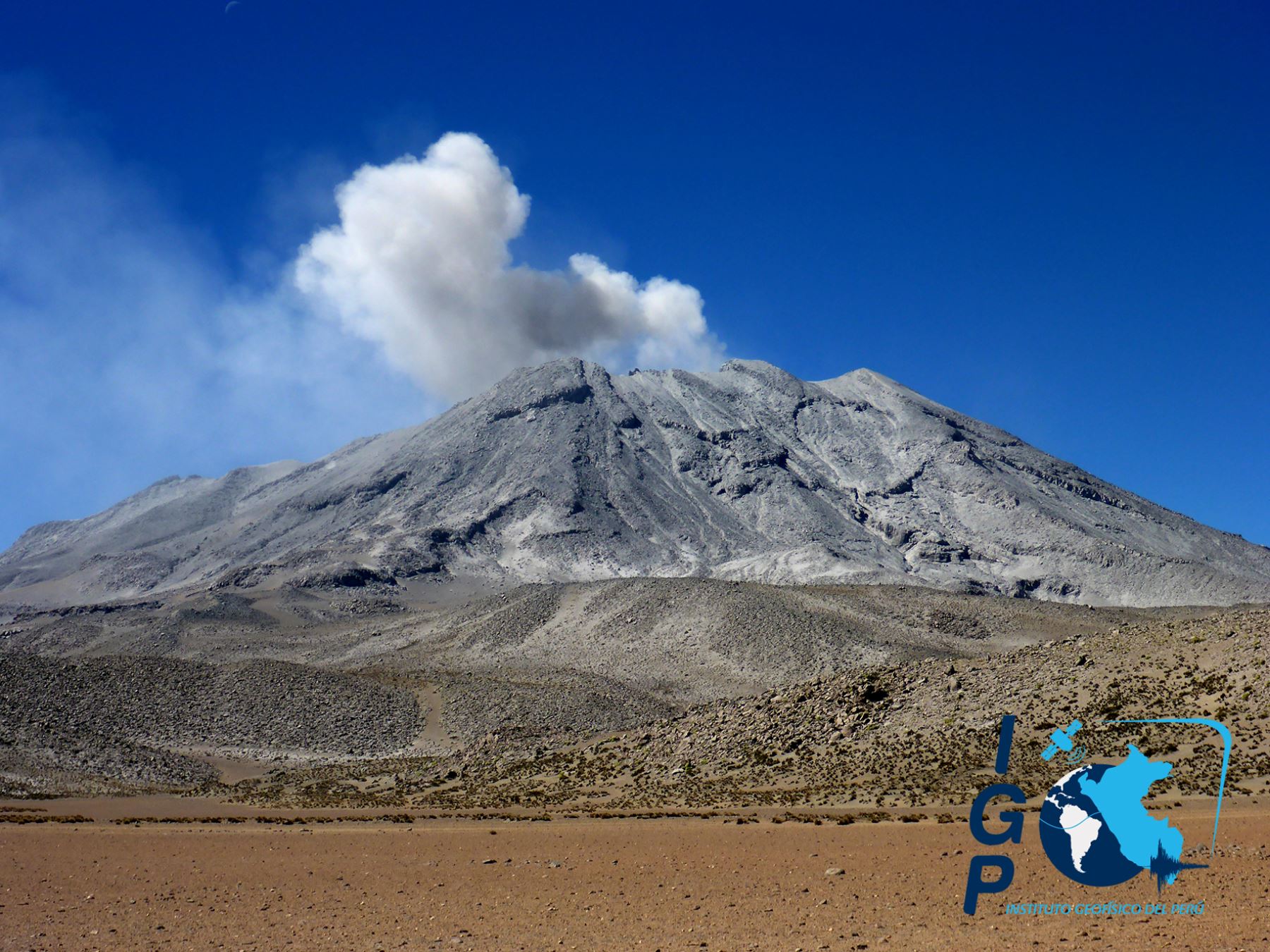
During the period from December 9 to 15, the IGP recorded and analyzed a total of 156 seismic events associated with the eruptive process of the Ubinas volcano, among which the Volcano-Tectonic (VT) type seismic signals predominate, related to the fracturing of rocks inside the volcano, which recorded an average of 10 earthquakes per day, all of magnitude less than M1.8. The seismic signals linked to the rise of magma (hybrid type) have decreased, both in number of events (7 daily earthquakes) and in energy. It should be noted that no volcanic explosion has been recorded since September 12.
Surveillance cameras recorded light and sporadic emissions of blue gases (of magmatic origin) and water vapor with heights less than 500 m above the summit of the volcano. Monitoring the deformation of the volcanic structure, using GNSS data (processed with fast orbits), does not record any anomalies. MIROVA satellite surveillance also did not record thermal anomalies on the volcano.
Source : IGP