Septembre 08 ,2019.
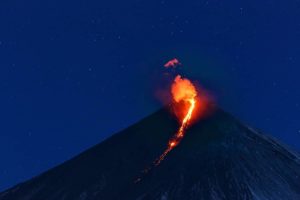
Italy , Stromboli :
Daily Bulletin of 07/09/2019
SUMMARY OF ACTIVITY REPORT
In light of the surveillance data, we highlight:
1) VOLCANOLOGICAL OBSERVATIONS: Normal explosive activity of Strombolian type accompanied by degassing activities.
2) SISMOLOGY: The seismological parameters do not show any significant changes.
3) DEFORMATIONS: There is no significant change regarding GNSS permanent networks and tilt meters.
4) GEOCHEMISTRY: The flow of SO2 indicates a degassing regime at a medium-high level.
https://www.facebook.com/1716786028369949/videos/493056754846691/
Strombolian persistent activity of ordinary intensity and discontinuous splashing. It is not possible to exclude the occurrence of explosions of greater intensity than ordinary emissions and lava flows. In case of heavy rainfall, it is not possible to exclude the formation of lahars following the remobilization of the pyroclastic deposits of paroxysms of July 3 and August 28, 2019.
VOLCANOLOGICAL OBSERVATIONS
During the period in question, the eruptive activity of Stromboli was characterized by the analysis of thermal and visible images recorded by the network of cameras located at altitude (400 SQV and SQT), in Punta dei Corvi (SPCT) and 190 m (SCT).
The total number of explosions was between 18 and 21 events / hr (medium-high frequency). In the North Zone, there were 15-16 explosions / h of medium to low intensity (less than 120 m in height) emitting coarse material. It should be noted that in the southern part of the North zone splashes are very intense. In the Center-South zone, an average frequency of 5 to 6 events / h was observed emitting coarse materials mixed ash with heights ranging from low to medium (sometimes the products reach a height of 150 m). In conclusion, the observations indicate that the explosive activity, compared to the ordinary characteristics of Stromboli, is at an average level.
Seismology
The bulletin is established with data acquired from a maximum of 7 stations. The seismic activity recorded during the last 24 hours has the following characteristics: No seismic signal associated with a landslide has been recorded.
Very long period (VLP) event logging provides an average of approximately 27 events / hour. The magnitude of the VLP events showed values generally ranging from low to medium to low. The amplitude of the explosion earthquake showed values generally between low and medium low, with some events of medium to high amplitude.
Source : INGV Vulcani.
Video : INGV.
Photo : Ronny Quireyns via Volcanoadventures.
Indonesia , Tangkuban Parahu :
Level of activity at Level II (WASPADA). The Tangkuban Parahu (2084 m above sea level) erupted on July 26, 2019 at 3:48 pm: 18 Western Indonesia time with a column of ash rising to within 200 m above the summit (± 2284 m above sea level). Following a second eruption on August 1, 2019 at 20:46, the smoke column was 180 m above the crater floor, followed by two eruptions on August 2, 2019 from 00:43 and 04:00. 56 hours of western Indonesia. Another eruption occurred on August 31, 2019 at 9:30 am with a column of ash about 150 meters high from the bottom of the crater. Since yesterday until this morning, the volcano was clearly visible. The CCTV observed a moderate to thick white smoke with a 200 meter high column and a 50-200 m ash column above the base of the crater.
https://www.facebook.com/sagara.manik/videos/131250718162258/
The seismographs, on September 7, 2019, recorded:
1 earthquake of eruption
5 emission earthquakes
1 distant tectonic earthquake
Continuous Tremor amplitude 2 – 50 mm, dominant value 30 mm
Recommendation: Communities around Mount Tangkuban Parahu and visitors / tourists / mountaineers should not approach the crater within 1.5 km of the active crater. It is recommended to temporarily close the Tangkuban Parahu Nature Park for a greater safety distance.
VONA: The latest code VONA received the color code ORANGE, published August 2, 2019 at 4:20 WIB, relating to the observation of the emission of volcanic ash at 1:45 WIB. With the height of the ash column not observed.
Source : PVMBG .
El Salvador , Santa Ana (Ilamatepec) :
Location: shared by the departments of Santa Ana and Sonsonate
Altitude: 2381 meters above sea level
Type of volcano: Stratovolcano
Type of activity: Vulcanian- Strombolian.
Last eruption: October 1, 2005.
The seismic vibration of the volcano remained between 17 and 21 RSAM units per day, that is to say in the normal range. A total of 58 earthquakes related to the movements of fluids in the volcanic system were recorded during the month of August. With regard to the earthquakes associated with the rupture of solid media, 4 were recorded and one of them was located on the northwest flank of the volcano crater, with a depth of less than 9 km and a magnitude less than M2.0. Due to its small size, it was not reported as felt by the inhabitants of the region. According to the monitoring, the activity of the volcano remains normal.
Source : Marn.
Photo : Volcano.USAF.C-130.3.
Costa Rica , Turrialba / Poas / Rincon de la Vieja :
Daily report of the state of volcanoes. Date: September 07 , 2019.
Updated at: 17:49:00.
Turrialba Volcano:
No eruption is reported.
The seismic activity is lower than yesterday.
At the time of this report, the winds blow from the northwest.
During the past 24 hours, seismographs have recorded a small amount of low-frequency, long-period LP-type volcanic earthquakes. We associate these LPs with the transport of fluids (water, vapors, gas) through ducts and cracks inside the volcano and in fumaroles. The vapor and aerosol plume is rich in water vapor and contains a low particulate load. The OVSICORI-UNA volcanic gas monitoring station in Coronado has recorded the lowest SO2 concentrations recorded in the past year, barely detectable and 0.5 ppb.
Poas Volcano:
No eruption is reported
The seismic activity is higher than yesterday.
At the time of writing, winds are blowing from the southwest.
Many seismic signals of low frequency volcanic tremors continue to be recorded with a configuration suggesting the movement of fluids (water, gas, steam or magma) through the ducts in a steady and steady manner, so that the transport of materials to the interior of the volcano seems to take place without substantially altering the conditions and characteristics of the environment in which the fluids are moving.
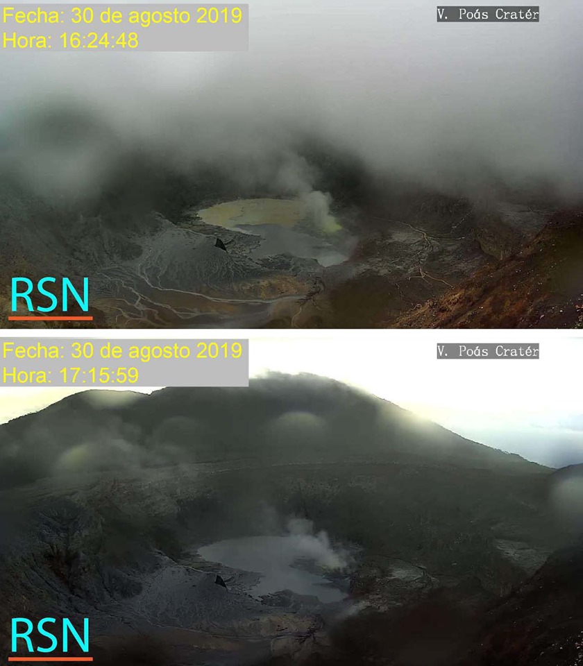
These images taken on Friday, August 30, 2019, were made with a difference of about 50 minutes with the volcanic camera of the volcano Poás of the RSN.
The upper image shows the crater lake with two different colors at the same time. The northern sector of the lake was yellowish in color while the southern sector was dark gray in color.
In the photo below, you can see the lake with only one gray shade. The yellowing of the first photo can be explained by the sulfur inputs into the lake from the fumarole field located in the East sector.
The gray color is explained by the trail of ash caused by runoff after the typical rains of the season.
Rincon de la Vieja Volcano:
No eruption is reported.
The seismic activity is similar to that of yesterday.
At the time of writing, winds are blowing from the Southwest.
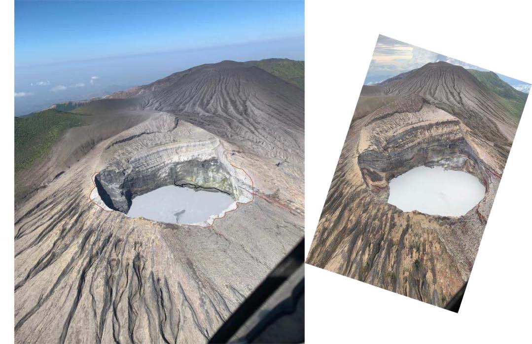
Comparison of oblique aerial photographs of the active crater of Rincon de la Vieja volcano between February 2019 (left) and August 2019 (right).
In the image on the left, you can see sediment and ash deposits on the edges and walls of the crater, the fumaroles of the western sector more active, a level of lower acid lake (comparative black border compared to the month of August 2019); as well as sulfur spherules floating in the lake.
In the photo on the right, recent eruption deposits are not identified and fumaroles are less active than in February 2019.
It continued to be recorded for several minutes and in a random pattern, tremors of low amplitude and very low frequency on the Rincon. The crater lake has a gray color, moderate evaporation on its surface and fumaroles with a low flow of fluids (water, steam, gas) in and out of the water. The lake level has increased by a few meters compared to the level observed in June 2019 (personal communication by Henriette Bakkar, OSIVAM-ICE).
Source : OVSICORI-UNA.
Photos : jcarvaja17 , RSN , Christopher Allen / Sunquest Helitours.