August 14 , 2019.
La Réunion , Piton de la Fournaise :
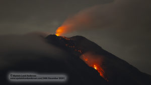
The Laves road was stormed on Tuesday night by amateur volcanologists. The eruption started on Sunday around 16 h 20, continues its slow descent to the RN 2. The flow was yesterday, 2 km.
The incandescent lava pierces the night. Its slow glowing flow is hypnotic. Despite the traffic jams, the gloomy weather and the freshness of the night, the crowd rushes to the event.
https://www.facebook.com/ObsVolcanoPitonFournaise/videos/2102101350091064/
Flying over the active crack this morning from August 13th at 9:30 am with the help of SAG and PGHM. © OVPF-IPGP
Seismology:
– Number of landslides of 13-08-2019: 5
Area affected by landslides: Top Cone
– Number of volcano-tectonic earthquakes (VT) from 13-08-2019: 5
Area affected by VTs: Top Cone
– Volcano-tectonic earthquake of greater magnitude of 13-08-2019:
Duration: 3.84 s
Magnitude of duration: 0.30
Source : la1ere.francetvinfo.fr, OVPF ( http://volcano.ipgp.fr/reunion/Bulletin_quotidien/bulletin.html ) .
Kamchatka , Karymsky :
VOLCANO OBSERVATORY NOTICE FOR AVIATION (VONA).
Issued: August 14 , 2019
Volcano:Karymsky (CAVW #300130)
Current aviation colour code:ORANGE
Previous aviation colour code:orange
Source:KVERT
Notice Number:2019-116
Volcano Location:N 54 deg 2 min E 159 deg 26 min
Area:Kamchatka, Russia
Summit Elevation:4874.08 ft (1486 m)
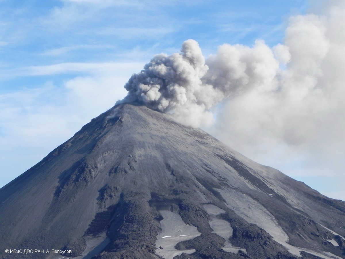
Volcanic Activity Summary:
According to visual data by volcanologists which work near the volcano, explosions send ash up to 4.0-4.5 km a.s.l., ash clouds drift to the east of the volcano.
A moderate eruptive activity of the volcano continues. Ash explosions up to 19,700 ft (6 km) a.s.l. could occur at any time. Ongoing activity could affect low-flying aircraft.
Volcanic cloud height:
13120-14760 ft (4000-4500 m) AMSL Time and method of ash plume/cloud height determination: 20190814/0445Z – Visual data
Other volcanic cloud information:
Distance of ash plume/cloud of the volcano: 3 mi (5 km)
Direction of drift of ash plume/cloud of the volcano: E
Time and method of ash plume/cloud determination: 20190814/0445Z – Visual data
Source : Kvert.
Photo : A. Belousov, IVS FEB RAS.
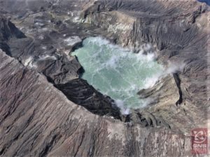
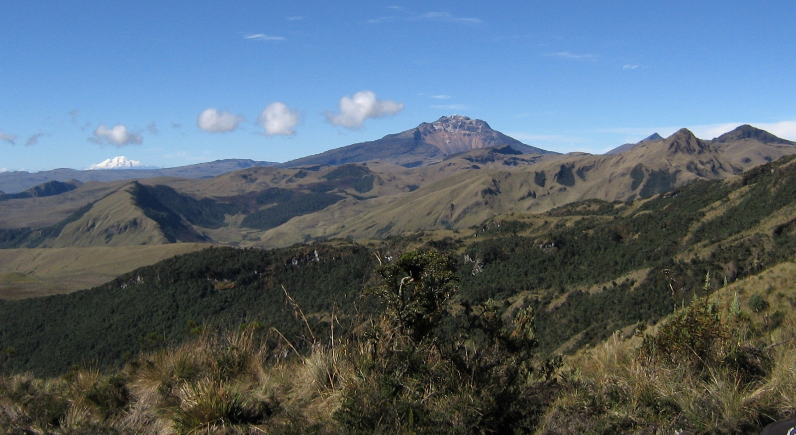
Colombia , Chiles / Cerro Negro :
Weekly activity bulletin of Chiles and Cerro Negro volcanoes
The level of activity of volcanoes continues at level: LEVEL YELLOW ■ (III): CHANGES IN THE BEHAVIOR OF THE VOLCANIC ACTIVITY.
Following the activities of VOLCANS CHILES AND CERRO NEGRO, the COLOMBIAN GEOLOGICAL SERVICE (SGC) reports that:
Between August 6 and 12, 2019, seismic activity in the Chiles – Cerro Negro volcano region increased from 137 to 392 events. The seismic energy released this week also recorded an increase over the previous week. Most of the localized earthquakes were located south-southwest of the Chiles volcano, at a maximum distance of 2.5 km and at a depth of less than 6 km below the summit of the volcano (at an altitude of 4,700 meters). The maximum local magnitude calculated for this week was 2.8 on the Richter scale. None of the earthquakes recorded during the period evaluated were reported as being felt in the area of influence of the Chile-Cerro Negro Volcanic Complex.
According to the special report prepared by the Geological Survey of Colombia and the Institute of Geophysics of the National Polytechnic School of Ecuador, published on August 1, 2019, fluctuations in seismicity, associated with other physicochemical parameters, record changes slow but that are maintained in time, allowing us to consider as one of the scenarios the probability that earthquakes of significant magnitude could be felt by the inhabitants of the zone of influence of Chiles – Cerró Negro volcanoes.
The Colombian Geological Service and the Institute of Geophysics of the National Polytechnic School of Ecuador are attentive to the evolution of the volcanic phenomenon and inform in good time on the observed changes. Due to the fluctuating and permanent development of seismic activity in the region of these volcanoes, the possibility of occurrence of earthquakes with higher energy levels than those reported can not be ruled out.
Source : SGC.
Photo : SGC.
Peru , Sabancaya :
Period of analysis: August 5 to 11, 2019. Arequipa, August 12, 2019
Alert level: ORANGE
The Geophysical Institute of Peru (IGP) reports that the eruptive activity of the Sabancaya volcano has remained at moderate levels; that is, with the recording of continuous explosions and the resulting ash emission. Therefore, for the following days, no significant change is expected.
The analysis of records obtained from the seismic network of the Sabancaya volcano for the period from August 5 to 11, 2019 has identified the occurrence of about 2227 earthquakes of volcanic origin, the highest percentage of which is associated with the movement of magmatic fluids. During this week, there was an average of 30 explosions per day of moderate to low intensity.
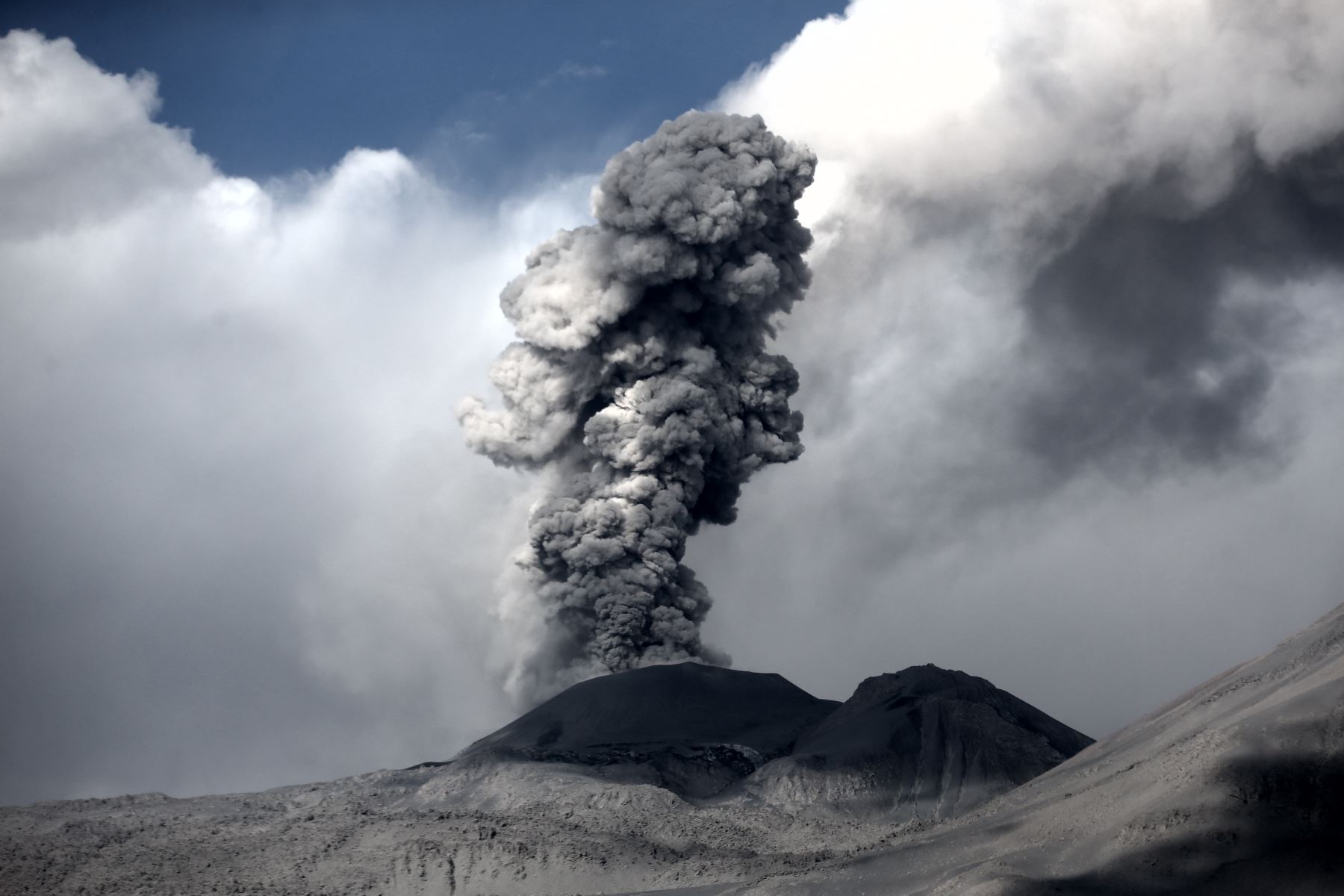
The monitoring of the deformation of the volcanic structure, using GNSS data (processed with fast orbits), does not present significant anomalies. Visual surveillance, using surveillance cameras, identified the appearance of columns of gas and ash up to 4 km high above the top of the volcano, which dispersed in the SW, NE sectors. and SE of Sabancaya. Satellite monitoring identified 9 volcanic anomalies on the volcano ranging from 3 to 49 MW, associated with the presence of a hot body near the surface and the persistence of explosions.
RECOMMENDATIONS
• Do not approach within 12 km of the crater. In case of ash fall, cover your nose and mouth with damp cloths or masks. Keep the doors and windows of the houses closed.
• Implement prevention and mitigation actions in response to an increase in volcanic activity.
OUTLOOK
• No significant changes in the current eruption process of Sabancaya volcano are expected in the following week.
• In the event of a volcanic explosion, the ashes would be dispersed, preferably towards the south-east and south sectors of the volcano, with moderate to strong winds exceeding 30 km / h. From August 15 to 17, dispersal would occur to the North and Northeast areas, conditioning dispersal over distances greater than 30 km.
Source : IGP Peru .
Photo : Auteur inconnu.
Hawaii , Kilauea :
19°25’16 » N 155°17’13 » W,
Summit Elevation 4091 ft (1247 m)
Current Volcano Alert Level: NORMAL
Current Aviation Color Code: GREEN
Activity Summary:
Kīlauea Volcano is not erupting. Monitoring data continue to show steady rates of seismicity and ground deformation, low rates of sulfur dioxide emission, and only minor geologic changes since the end of eruptive activity in September 2018. Water has begun pooling at the lowest elevations in summit crater. Currently there are two small puddles that began forming on July 25, 2019 and August 1, 2019. These puddles continue to slowly expand and deepen.
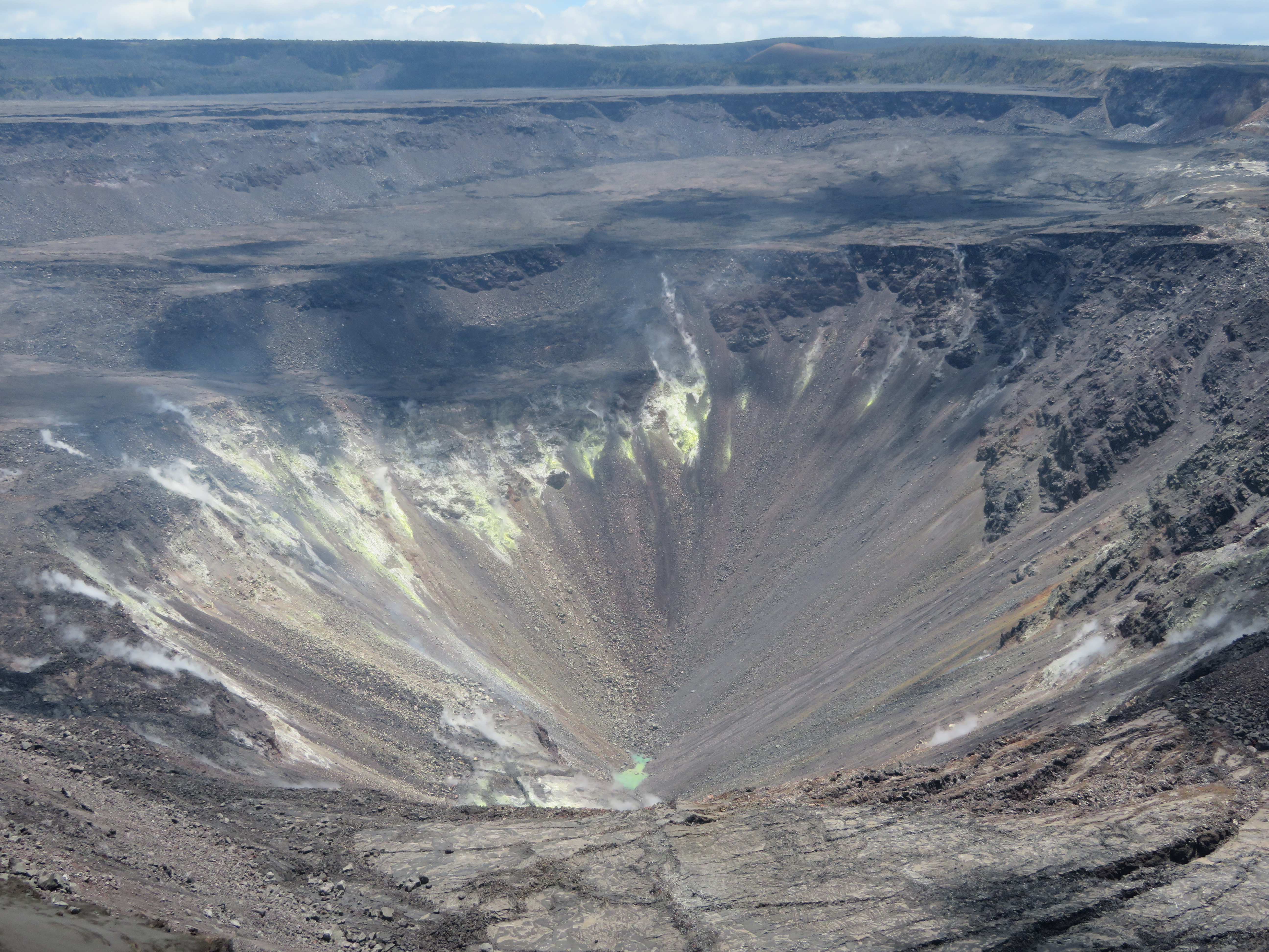
The ponded water at the bottom of Halema‘uma‘u has continued to slowly rise. This wide view shows much of Halema‘uma‘u and the fumaroles on the upper walls of the pit. USGS photo by M. Patrick, 08-11-2019.
Observations:
Monitoring data have shown no significant changes in volcanic activity over the past week. Rates of earthquake activity or seismicity across the volcano remain low. Sulfur dioxide emission rates are low at the summit and are below detection limits at Puʻu ʻŌʻō and the Lower East Rift Zone.
Although not currently erupting, at and uprift of the 2018 lower East Rift Zone eruptive fissures, there are areas of persistently elevated ground temperatures and minor release of gases. These include steam (water), very small amounts of hydrogen sulfide, and carbon dioxide. These conditions are expected to be long-term. Similar conditions following the 1955 eruption continued for years to decades after the end of activity.
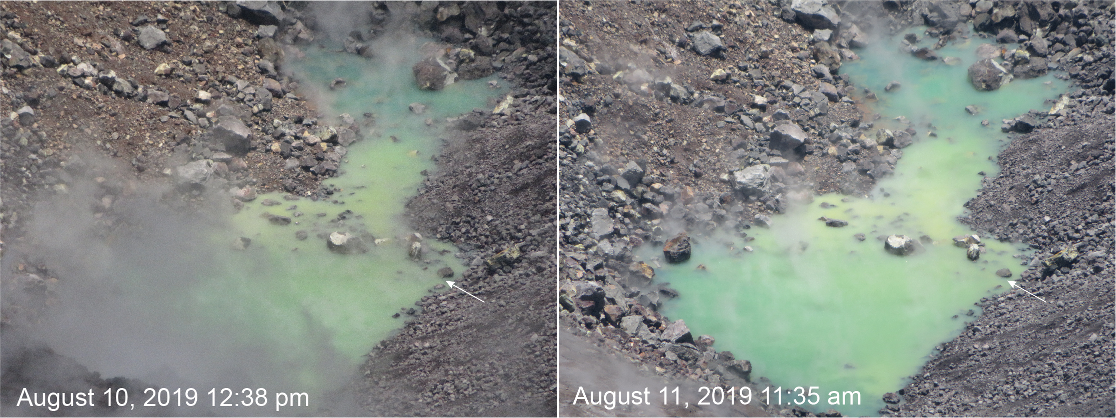
This comparison between Saturday, August 10, and Sunday, August 11, shows a slight rise in the water level. The day-to-day rise in water level is smaller than the precision of our laser rangefinder (about 1 meter) at this long distance, so photo comparisons and close inspection of the water level against key rocks is the best tool to see these small changes. Compare the water level at the small rock on the edge of the pond (marked by an arrow in each photo) to note how it has risen. USGS photos by M. Patrick.
Since early March 2019, GPS stations and tiltmeters at the Kīlauea summit have recorded deformation consistent with slow magma accumulation within the shallow portion of the Kīlauea summit magma system (1-2 km or approximately 1 mile below ground level). However, gas measurements have yet to indicate significant shallowing of magma. HVO continues to carefully monitor all data streams at the Kīlauea summit for important changes.
Further east, GPS stations and tiltmeters continue to show motions consistent with slowed refilling of the deep East Rift Zone magmatic reservoir in the broad region between Puʻu ʻŌʻō and Highway 130. While the significance of this pattern is unclear, monitoring data do not suggest any imminent change in volcanic hazard for this area. In addition to motion along the East Rift Zone, the south flank of Kīlauea continues to creep seaward at elevated rates following the May 4, 2018 M6.9 earthquake near Kalapana. HVO continues to carefully monitor all data streams along the Kīlauea East Rift Zone and south flank for important changes.
Source : HVO.