May 22 , 2019.
Hawaii , Kilauea :
19°25’16 » N 155°17’13 » W,
Summit Elevation 4091 ft (1247 m)
Current Volcano Alert Level: NORMAL
Current Aviation Color Code: GREEN
Activity Summary:
Kīlauea Volcano is not erupting. Monitoring data over the past nine months have shown relatively low rates of seismicity, deformation, and sulfur dioxide emissions at the summit and East Rift Zone, including the area of the 2018 eruption.
As of March 26, Kīlauea Volcano is at NORMAL/GREEN.
Despite this classification, Kīlauea remains an active volcano, and it will erupt again. Although we expect clear signs prior to a return to eruption, the time frame of warning may be short.
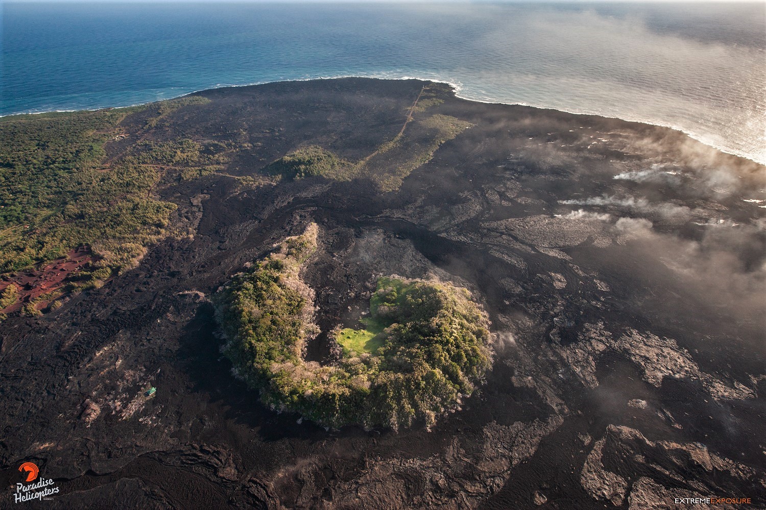
Good weather provided clear views of Halema‘uma‘u during a routine visit to the webcam on the northwest rim of the caldera. USGS photo by M. Patrick, 05/17/2019.
Observations:
Monitoring data have revealed no significant changes in volcanic activity over the past week. Generally low seismicity continues across the volcano, with earthquakes occurring primarily in the summit and south flank regions. The largest Kīlauea earthquake over the past week was a M2.8 event south of Mauna Ulu on May 20, at a depth of 3.6 km (2.2 miles) below ground level. USGS received 4 felt-reports following this event.
Since early March, tiltmeters at the Kīlauea summit have recorded modest inflationary tilt. Over about the same time period, a GPS station within the 2018 collapse area has recorded approximately 5 cm (3 inches) of uplift. Satellite radar data (InSAR) show deformation consistent with inflation of the shallow Halemaʻumaʻu source, confirming the trends noted by both tiltmeters and GPS. One possible interpretation is that magma has begun to slowly accumulate within the shallow portion of the Kīlauea summit magma system, 1-2 km or approximately 1 mile below ground level. However, gas measurements have yet to indicate significant shallowing of large volumes of melt. HVO continues to carefully monitor gas output at the Kīlauea summit and East Rift Zone for important changes.
Further east, GPS stations and tiltmeters continue to show motions consistent with refilling of the deep East Rift Zone magmatic reservoir in the broad region between Puʻu ʻŌʻō and Highway 130. This trend has been observed since the end of the 2018 eruption, and while its significance is unclear, monitoring data do not suggest any imminent change in volcanic hazard for this area.
Source : HVO.
Photos : USGS / M. Patrick, 17/05/2019. Bruce Omori ( 2018).
Colombia , Chiles / Cerro Negro :
Weekly activity bulletin of Chiles and Cerro Negro volcanoes.
The activity level of volcanoes continues at the level: YELLOW LEVEL ■ (III): CHANGES IN THE BEHAVIOR OF THE VOLCANIC ACTIVITY.
Following the activity of the CHILE / CERRO NEGRO volcanoes, the COLOMBIAN GEOLOGICAL SERVICE (SGC) reports that:
During the period evaluated between 14 and 20 May 2019, seismic activity in the Chiles – Cerro Negro volcano region continued to increase, mainly reflected in the number of events, from 2695 to 7528 volcano-tectonic earthquakes, associated with a fracture of rocky materials in the volcanic building. The seismic energy released by these events has gradually decreased, especially in recent days.
This seismicity was concentrated to the south and south-east of the Chiles volcano, at depths less than 8 km below the summit (4700 m altitude). The presence of 3 earthquakes reported as having been felt by the inhabitants of the Chiles and Cerro Negro volcano zone of influence is highlighted, with a maximum local magnitude of 3.5 on the Richter scale, the most energetic ‘between them having been recorded on May 15 at 8:14 with a local magnitude of M3.5. The 20:50 event of May 15 is also highlighted, which, with a magnitude of M 3.2, has also been reported as having been felt.
Other geophysical and geochemical parameters of volcanic monitoring did not show significant variations.
The COLOMBIAN GEOLOGICAL SERVICE is attentive to the evolution of the volcanic phenomenon and will continue to inform in a timely manner of the observed changes.
Source : SGC
Photo : Auteur inconnu.
Ecuador , Sangay :
Special report on the Sangay volcano N ° 3 – 2019.
Update of the eruptive activity.
Summary:
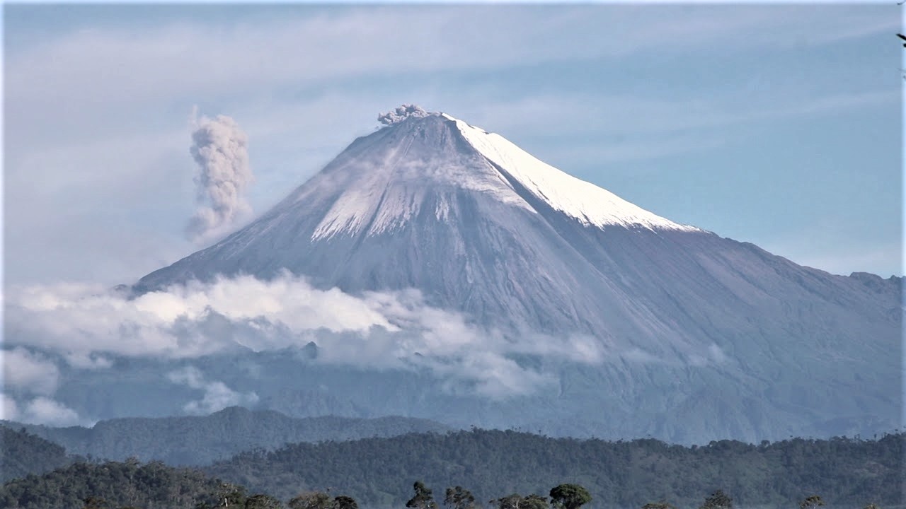
The Sangay volcano, in the Morona Santiago province, is continuing its new eruptive phase that started on May 7 until the publication of this report (14 days). It is highlighted the activity of two eruptive centers, the central crater and the dome of Ñuñurcu (Southeast). The central crater has an explosive activity that produces small ash clouds about 1 km above the crater, directed to the west and northwest and emits blocks that roll along the flanks to about 2.5 km from the crater. So far, no ashfall has been reported in surrounding populated areas. The Ñuñurcu dome has an effusive activity with a lava flow over 470 m long that descends to the south-east flank. The collapses of the front of the lava flow generate falls of blocks and small pyroclastic flows (hot avalanches of gas, ashes and blocks).
Visual observations and surface activity.
The surface activity of the Sangay volcano is evaluated on the basis of the analysis of satellite images, images provided by the Macas ECU 911 and sequences of visible and thermal images obtained during an overflight carried out by the personnel. of the IG-EPN on 17 May. Since the publication of Special Report No 2 (https://www.igepn.edu.ec/sangay-informes/sang-especiales/sang-e-2019/22297-report-especial-sangay-n-2-) 10 -05-2019-2 / file) two eruptive centers were clearly identified, each with a different behavior.
1. central crater:
Its activity is characterized by sporadic explosions that project ballistic missiles (incandescent rocks with parabolic trajectories) at a speed greater than 400 km / h. These projectiles land on the cone and roll for 2.5 km on the south-east flank (Fig. 1). The ash columns associated with these explosions reach varying altitudes between 500 and 2300 m above the crater (average of 1000 m) and their dispersion by wind is mainly oriented towards the West and the North-West. In addition, on the Sentinel-2 satellite image and the May 17 flyby photographs, volcanic gas emission is observed from the central crater west-southwest (Fig. 1).
2. Ñuñurcu dome:
The Ñuñurcu dome is located about 190 m south-south-east of the central crater (Fig. 1). Its activity is characterized by the emission of a lava flow whose maximum range from its emission point is greater than 470 m (altitude: 4825 m above sea level). The stream has a maximum width of approximately 175 m and an estimated area of 60 000 m2 (6 hectares). Using an average thickness of 5 to 10 m, a minimum volume of 300,000 to 600,000 m3 (equivalent to 120 to 240 Olympic swimming pools) is estimated. Small pyroclastic flows and many falling rocks were caused by the collapse of the lava flow front. One of these pyroclastic flows reached a distance of 340 m from the front of the lava flows (altitude: 4675 m), a maximum width of 60 m and an area of approximately 14,300 m2 (1.4 hectares).
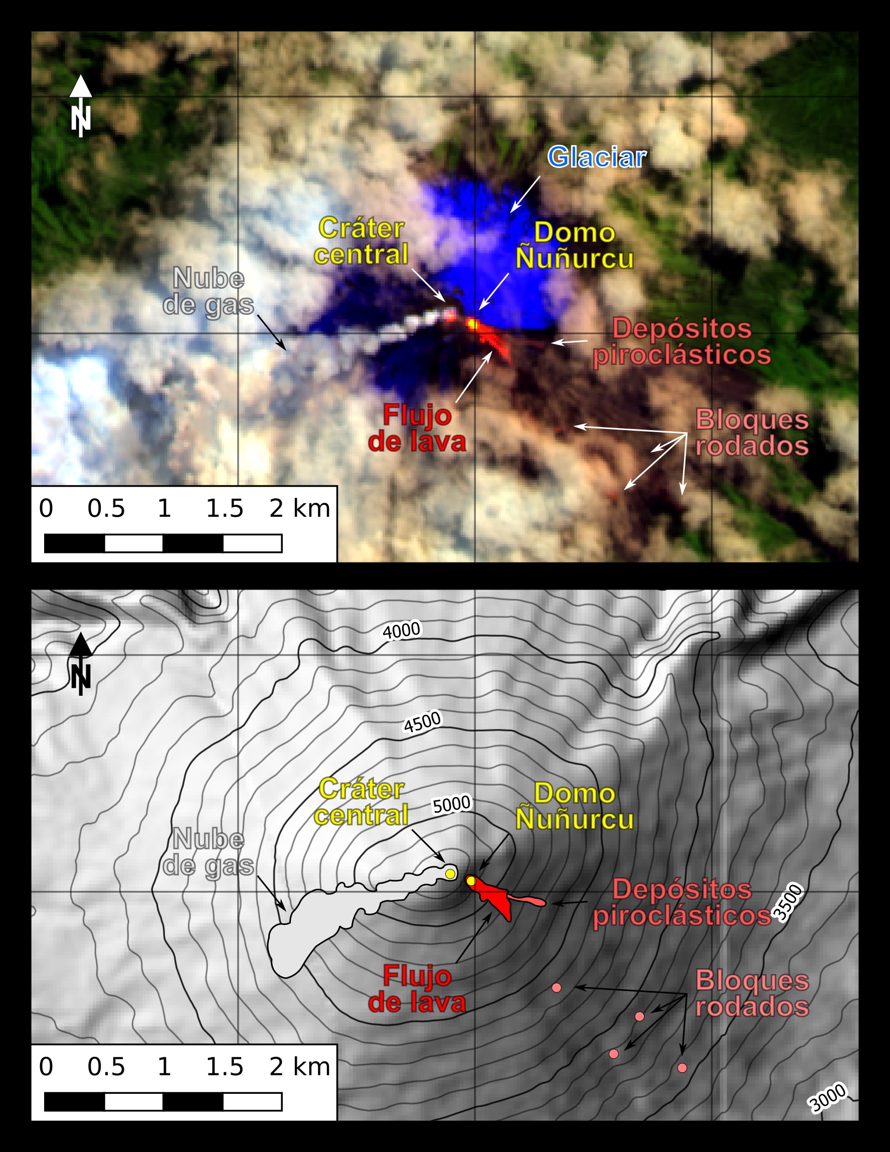
Figure 1. Sentinel-2 image (RGB bands – B12; B11; B4) dated 17/05/2019, provided by Sébastien Valade (MOUNTS: http://www.mounts-project.com/volcano/352090) and mapped to 1/50 000 scale of the Sangay volcano with 30 m land model interpretation (WGS84, Zone 17S) (Developed by: B. Bernard).
Thermography.
The thermal images show that the lava flow is wider, but shorter than that emitted between August and September 2018 (for example, https://www.igepn.edu.ec/sangay-informes/sang-especiales/ blood- e-2018/21713-special-report-sangay-n-2-21-11-2018 / file). In addition, a crack observed during a previous overflight (April 12, 2018) is active with gas emission (Fig. 2).
The central crater has maximum apparent temperatures (TMA) of up to 217 ° C and lava flow up to 277 ° C. At the time of overflight, the pyroclastic deposits were still hot, but no reliable TMA was obtained (Fig. 2).
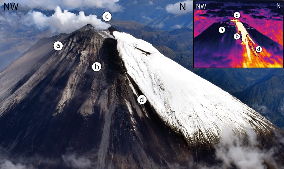
Figure 3. Photograph of the visible band on the southern flank of Sangay Volcano. The corresponding thermal image is visible in the upper right corner. Sites: a) crack associated with the emission of lava flows through the « Domo Ñuñurcu » vent. b) Active lava flow from the Ñuñurcu dome. c) Central crater and column emissions of volcanic gas. d) Pyroclastic flow derived from the collapse of the lava front. (Photo and image: M Almeida, May 17, 2019).
Interpretation.
According to the analysis presented, the volcano continues with activity of the explosive type (central crater) and effusive (domo Ñuñurcu). This activity is typical of the eruptive phases of Sangay in recent years. The ash columns reached a maximum height of 2.3 km at the top of the volcano, without causing ash falls in nearby cities. The main volcanic hazards associated with this activity are the ballistic projectiles and lava frontages that can reach several kilometers. At present, there is no evidence of a change in the volcano’s behavior and, if it is similar to previous eruptive periods, the eruptive phase should last several weeks to several months with the same activity. However, it is important to note that a more complete forecast can not be made due to the lack of geophysical data and that an increase in activity in the future can not be excluded.
Source : IGEPN . https://www.igepn.edu.ec/servicios/noticias/1733-informe-especial-del-volcan-sangay-n-3-2019
Photos : Galapagos Tours Nature Galapagos & Ecuador sept 2018 , IGEPN.
La Guadeloupe , La Soufrière :
Press release, Monday, May 20, 2019 at 9:00 am date: 2019-05-20
Sequence of earthquakes in La Soufrière area of Guadeloupe – Basse Terre
The sequence of volcanic earthquakes that began in the La Soufrière volcano area on May 15, 2019 at 05:05 local time (May 15 9:05 am Universal Time *, UT) ended on Sunday, May 19 at 8:41 UT. During this sequence, 150 earthquakes were recorded.
The earthquakes were of very small magnitude (M <1). The events are located at a depth of <2.5 km under the summit of the dome of La Soufrière. No earthquakes were reported felt by the population.
The alert level remains: yellow, vigilance.
Source : Direction de l’OVSG-IPGP
Photo : A.-Brusini-hemis-fr