March 07 , 2019.
La Réunion , Piton de la Fournaise :
Activity Bulletin from Wednesday, March 6, 2019 to 17:00 (local time).
The eruptive activity that resumed on February 19, 2019 at Piton de la Fournaise around 7:10 pm local time continues. Despite slight fluctuations in intensity and a downward trend observed for nearly 24 hours, tremor intensity has been relatively stable since February 28 (Figure 1).
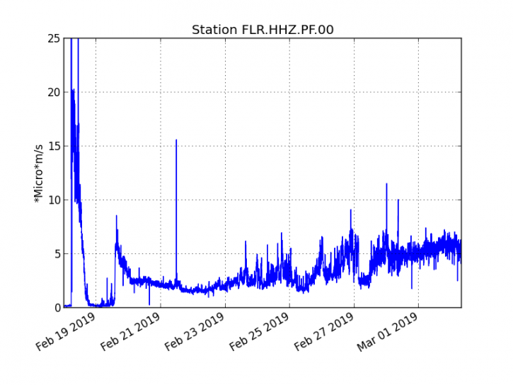
Figure 1: Evolution of the RSAM (indicator of the volcanic tremor and the intensity of the eruption) between 09h48 (05h48 UTC) on February 18th and March 6th at 16h30 (12h30 UTC) on the seismic station of FLR. (© OVPF / IPGP)
– Over the last 36 hours, no upper surface volcano-tectonic earthquake (above sea level) has been recorded.
– After a deflation of the building related to the transfer of magma that occurred on 18/02/2019, the summit area does not show any particular deformation signals.
– The CO2 concentrations in the near-field soil (cottage volcano area) remain high.
– The mediocre weather conditions on the Fournaise massif this day did not allow any observation on the ground.
– A cartography of the lava flow dated March 6, 2018 carried out by the OI2 platform (OPGC – University Clermont Auvergne) from satellite data shows a slight evolution of the contour of the flows (Figure 2) since March 1st.
– Over the last 36 hours, surface flows estimated from satellite data, via the HOTVOLC platform (OPGC – Clermont Auvergne University), fluctuated between <1 and 12 m3 / s (these measures were largely affected / reduced by the cloud cover since early morning).
Activity Bulletin from Wednesday, March 6, 2019 to 18:30 (local time).
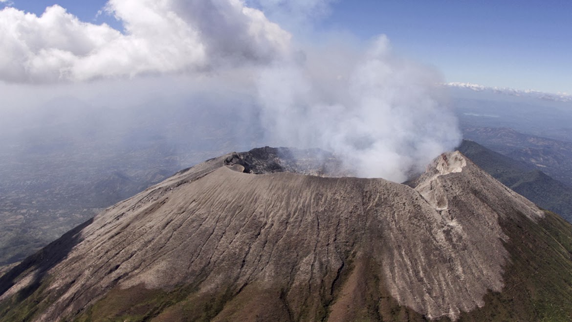
The OVPF confirms the opening of a new crack upstream of the eruptive site (on the northern flank of Piton Madoré). This new crack was observed this morning by a tourist during a helicopter flight (between 7:00 am and 8:00 am local time).
This new lava emission point was probably opened on March 5th (yesterday) between 9:00 am (local time, crack not present during the flight of an OVPF team) and before 7:00 pm (local time, time of day). acquisition of a satellite image on which an extremely weak signal can be detected at the level of the new crack (OI2 data, Clermont Auvergne University).
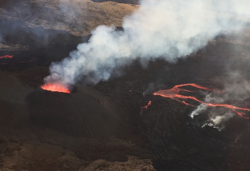
This morning, according to the photos and satellite images just provided, a small cone was already being formed and a new flow had begun to progress north of the main eruptive site. Due to the location of this new crack in the vicinity of the active vent since February 19 and associated low flow rates, its seismic signal coincides with that of the 19 February vent.
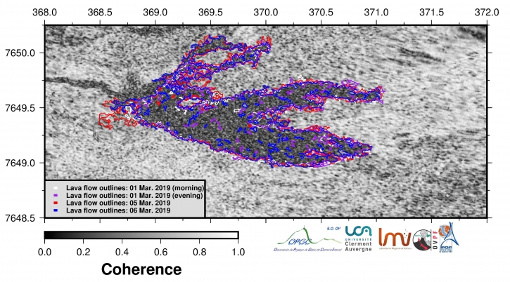
Figure 2: Evolution of the flows contour between March 1 and March 6, 2019 by the OI2 platform (Clermont Auvergne University).
This new lava emission point testifies to maintaining pressure in the supply duct. We can not exclude the opening of new fissures upstream or downstream of the eruptive site in the coming days.
Alert level: Alert 2-2
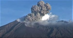
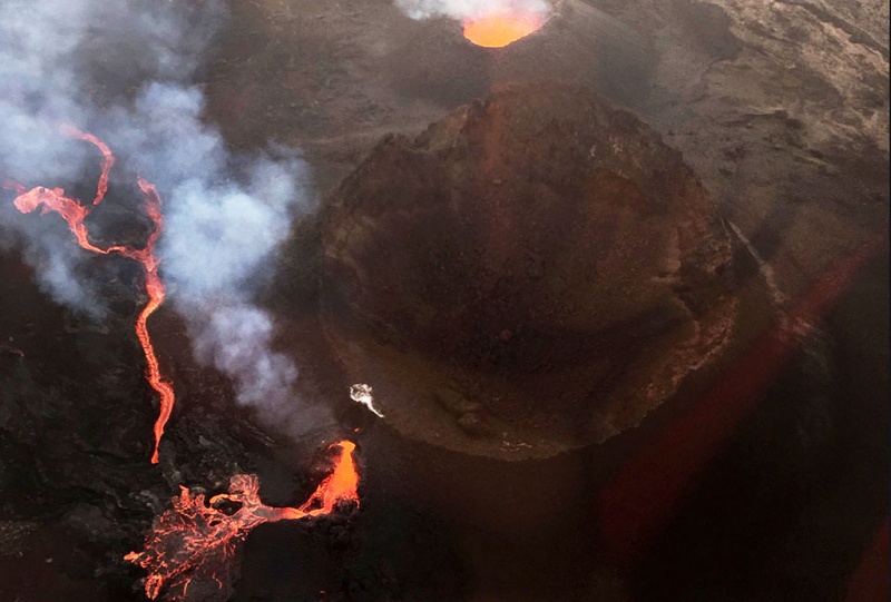
While the eruption of the Piton de la Fournaise began on February 18, 2019, a new crack opened and was observed very early this Wednesday morning around 6:00. The fracture was set up in the west and in contact with the crater Madore, that is to say exactly opposite and less than 200 meters from the crack opened on February 19th. This is a phenomenon rarely seen as many days after the onset of an eruption. « We can not exclude the opening of new fissure upstream or downstream of the eruptive site in the next few days, » commented the volcanological observatory. Directed by Sarah Mallet all the images of this new crack are just below
Located at 1800 meters above sea level, the new fault, from which escapes a lava flow, was photographed this morning during a helicopter tourist flight. In all likelihood, the crack opened at the end of the afternoon or early evening on Tuesday. Several other observations were then made.
Without being exceptional, this phenomenon remains relatively rare, especially as many days after the start of an eruption and at a distance as close as possible to the « original » crack. The same situation had occurred in 1999, but the break had opened much further from the first.
The greatest caution is recommended especially to people who venture into the pen to try to photograph or film the lava closer.
In the early evening the volcanological observatory published the following statement: « The OVPF confirms the opening of a new crack upstream of the eruptive site (on the northwestern flank of Piton Madoré) .This new crack was observed this morning by a tourist during a helicopter flight (between 7:00 and 8:00 pm).
Source : OVPF , ipreunion.com www.ipreunion.com/volcan/reportage/2019/03/06/-photos-phenomene-rare,volcan-une-nouvelle-fissure-s-ouvre-en-pleine-eruption,98748.html
Photo : Sarah Mallet.
Colombia , Chiles / Cerro Negro :
Weekly activity bulletin Chiles and Cerro Negro volcanoes.
The activity level of volcanoes continues at the level: YELLOW LEVEL ■ (III): CHANGES IN THE BEHAVIOR OF THE VOLCANIC ACTIVITY.
Following the activity of the CHILE volcanoes and CERRO NEGRO, the COLOMBIAN GEOLOGICAL SERVICE (SGC) reports that:
Between February 26 and March 4, 2019, seismic activity in the Chile – Cerro Negro volcano region recorded an increase in occurrence and released seismic energy, from a total of 2770 events, the week last, at 3224 events for this week. Most of the events continue to be associated with fracturing of the rock inside the volcano, with a preferential location south of the Chiles volcano, with epicentral distances of up to 4 km and depths of less than 6 km below the summit. (4700 m); a second source was located between 4 and 10 km southeast of Chiles, with depths between 8 and 11 km.
Almost all the calculated magnitudes were less than M 2.4 on the Richter scale; with the exception of the earthquake that occurred on March 2 at 3:58. with a magnitude of M3.1, which would have been felt in the area of influence of these volcanoes, in the indigenous reserve of Chiles.
The other geophysical and geochemical assessment parameters do not show significant variations.
The COLOMBIAN GEOLOGICAL SERVICE is attentive to the evolution of the volcanic phenomenon and will continue to inform in a timely manner of the observed changes.
Source : SGC
Photo : SGC
El Salvador , San Miguel ( Chaparrastique) :
Location: San Miguel Department
Altitude: 2,130 meters above sea level
Type of volcano: Stratovolcano
Attraction type: Strombolian – Vulcanian
Last major eruption: December 29, 2013.
At the end of the month, seismic vibration values tended to decrease and fluctuate around 50 units. Seismic vibrations fluctuated throughout the month between 48 and 219 RSAM units on average per day, when the normal is less than 150 units. A total of eleven small earthquakes (Ml <3) were located in the crater area of the volcano. None of the earthquakes were perceived by the population living in the volcano area.
With regard to sulfur dioxide (SO2) emissions, they fluctuated between 36 and 1035 tonnes per day, with an average of 465, below the threshold of 620. These values are considered typical of a volcanic duct system. open. According to monitoring, the activity of the volcano changes periodically, which is why sudden changes in its behavior are not excluded, with the possibility of emitting gases and ashes.
Source : Marn
Photo : Marn / Epa
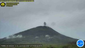
Indonesia , Dukono :
VOLCANO OBSERVATORY NOTICE FOR AVIATION – VONA.
Issued : March 06 , 2019
Volcano: Dukono (268010)
Current Aviation Colour Code: ORANGE
Previous Aviation Colour Code: orange
Source: Dukono Volcano Observatory
Notice Number: 2019DUK13
Volcano Location: N 01 deg 41 min 35 sec E 127 deg 53 min 38 sec
Area: North Maluku, Indonesia
Summit Elevation: 3933 FT (1229 M)
Volcanic Activity Summary:
Eruption with volcanic ash cloud at 09h00 UTC (18h00 local)
Volcanic Cloud Height:
Best estimate of ash-cloud top is around 4893 FT (1529 M) above sea level, may be higher than what can be observed clearly. Source of height data: ground observer.
Other Volcanic Cloud Information:
Ash cloud moving to southwest
Remarks:
Eruption and ash emission is continuing
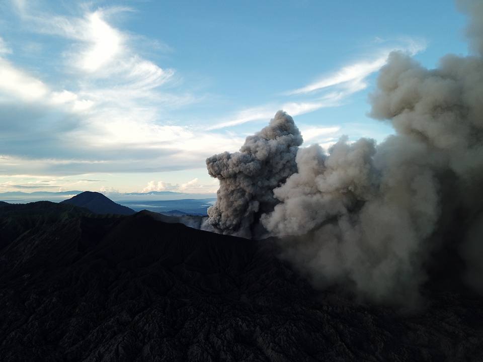
Level II Activity Level (WASPADA). The Dukono (1229 m altitude) undergoes continuous eruptions.
Since yesterday and until this morning, the volcano was clearly visible. It is observed that the smoke from the main crater is of medium pressure, white color, which rises to 300-900 meters of altitude. The wind is blowing weakly to moderately to the south.
Through the seismographs, on March 6, 2019, it was recorded:
1 eruption earthquake
5 distant tectonic earthquakes
Continuous tremor with amplitude 0.5 – 4 mm, dominant value 2 mm
Recommendation:
People around G. Dukono and visitors / tourists should not have activities, climb and approach the Malupang Warirang crater within 2 km.
Source : Magma Indonesia , PVMBG.
Photo : Auteur Inconnu.
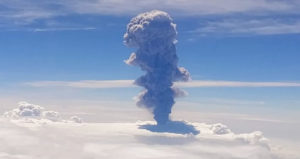
Mexico , Popocatepetl :
March 06, 11:00 am (March 06, 17:00 GMT)
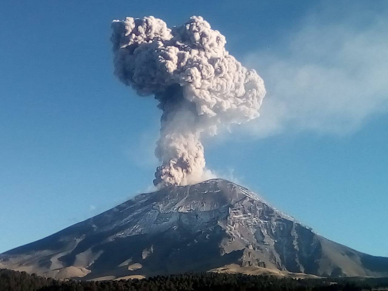
During the last 24 hours, through the monitoring systems of the Popocatepetl volcano, 97 exhalations have been identified, accompanied by water vapor, gas and light amounts of ash, as well as 61 minutes of activity sequence of type LP. This activity was recorded yesterday, and started at 10:36 and ends at 11:37. In addition, 100 minutes of harmonic tremor and an explosion were recorded today at 8:27. A continuous emission of low ash steam and volcanic gas and a volcano-tectonic earthquake was recorded today at 1:22 am with a magnitude of M2.1. During the night, incandescent and glowing fragments were also observed near the crater.
At the time of writing, wind disperses continuous emissions to the west and northwest (water vapor and volcanic gases)
Update from 06 March at 19:00 (07 March at 01:00 GMT)
At 17:56, the volcano had an explosion that generated a column of water vapor, gas with a moderate amount of ash 2.5 km above the crater, with a preferential direction towards the eastern sector. In addition, he projected fragments on the North-East, East and South-East slopes at a distance of 1 km. Ash falls are expected to occur in the municipalities of Atlixco, Cholula, San Nicolás de Ranchos, Nealtican, Tianguismanalco, Huaquechula and Tepeojuma in the state of Puebla.
https://www.facebook.com/Popocatepetlmx/videos/2278705535788861/
CENAPRED urges NOT to APPROACH the volcano and in particular the crater, this activity is envisaged in phases of Yellow Phase 2 traffic light. Any increase in activity will be reported in a timely manner.
Source : Cenapred .
Photo : Volcan Popocatepetl / Facebook.
Vidéo : Webcamdemexico .