September 29 , 2018.
Japan , Kusatsu Shirane :
Increased level of alert on Shirane volcano:
Volcanic earthquakes have increased on the Kusatsu Shirane volcano, and the Meteorological Agency has announced a warning around the crater on the night of the 28th, raising the level of the eruption alert to « 2 ». We call the guards to be vigilant for an area of about 1 km around the crater lake called Yukama.
According to the Meteorological Agency of Japan, volcanic earthquakes with epicenter sites near Yukama crater lake began at about 17:00 on September 28 in Shiraneyama, on the Kusatsu Shirane volcano, in the northwest of Gumma Prefecture. A small change is observed on the observation equipment.

The Meteorological Agency estimated that volcanic activity was increasing and announced a warning around the crater at 19:30, assuming there would be an eruption in the area around Yugama, and raised the level of eruption alert. at level 2.
Regarding the level of Shirane Volcano eruption alert, the Japan Meteorological Agency had dropped the level last month, at level 1 indicating « pay attention, it is an active volcano ».
Meanwhile, regarding the « Honkonama » crater of the Kusatsu Shirane volcano where the eruption occurred in January, it continues at level « 2 » and calls for vigilance about 1 km from the crater.
Source : 3.nhk.or.jp
La Réunion , Piton de la Fournaise :
Activity Bulletin of Friday, September 28, 2018 at 17:00 (local time).
The eruption started on September 15th at 4:25 am local time continues. The intensity of the volcanic tremor (indicator of surface eruptive intensity) has remained relatively stable over the last 24 hours (Figure 1).
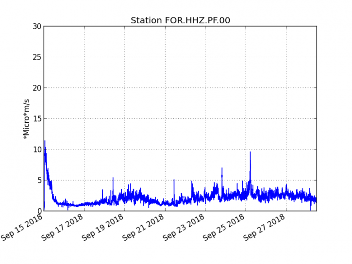
Figure 1: Evolution of the RSAM (indicator of the volcanic tremor and the intensity of the eruption) between 04h00 (00h UTC) on September 15th and 16h00 (12h00 UTC) on September 28th on the FOR seismic station, located near the crater Chateau Fort (2000 m altitude on the southeast flank of the terminal cone).
– No volcano-tectonic earthquake was recorded during the day of 26 September or during the current day.
– No significant deformation is noticeable.
– The surface flows estimated from the satellite data, via the HOTVOLC platform (OPGC – University Clermont Auvergne) are maintained and are always between 1 m3 / s and 2 m3 / s over the last 24 hours.
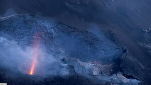
– No major change in the morphology of the eruptive vent. The activity continues in a completely closed cone. The flows always escape south of the cone through a main tunnel and emerge by resurgences located about 150-200m downstream south of the cone. The East arm has not been active for two days.
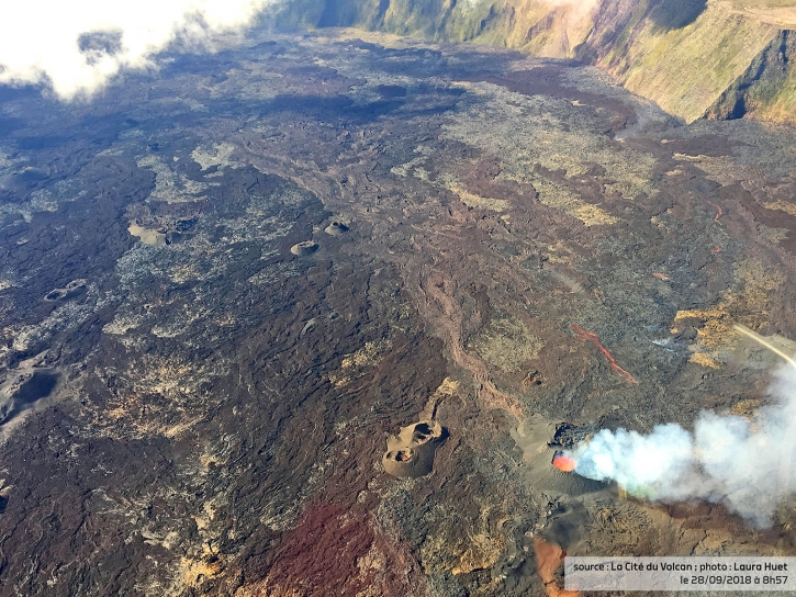
Figure 2: Shooting of the eruptive site on September 28, 2018 at 8:57 am local time (© Cité du Volcan / Laura Huet). (OVPF / IPGP)
Alert level: Alert 2-2 – Eruption in the Enclos .
On Friday, September 28, 2018, 23:51 (local time – 19:51 UTC), an earthquake was felt by islanders, mainly in the area of Maido.
This earthquake was recorded by the seismometers of the Volcanological Observatory of Piton de la Fournaise. The first analyzes of this earthquake made it possible to locate it 12 km below sea level in the Maïdo sector (sector west-north-west of Reunion). Its magnitude was measured at 1.8 on the Richter scale (Figure 1).
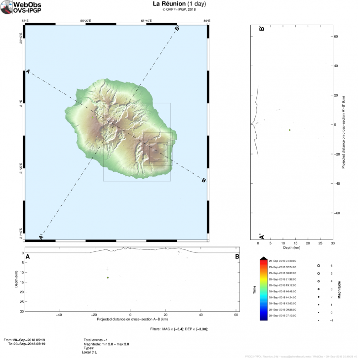
Figure 1: Location map of the earthquake felt in Reunion on September 28, 2018 at 23:51 (local time). (© OVPF / IPGP)
This type of event, felt by the population is recorded several times a year. This event is isolated and is of tectonic origin. At present, this earthquake has not been followed by replicas.
Source : OVPF
Sulawesi , Donggala earthquake :
Response to the Donggala M7.7 earthquake, Sulawasi Tengah, September 28, 2018
1. General information
A major earthquake occurred on September 28, 2018 at 17:02, with an epicenter at coordinates; 119.85o N 0.18o S, and a depth of 10 km, which began with the initial earthquake and was followed by a series of aftershocks in the Donggala region of central Sulawesi Province.
2. Geological conditions of the areas affected by the earthquake
The earthquakes struck the regency of Donggala. The area around the seismic center is generally composed of pre-tertiary, tertiary and quaternary rocks. Pre-tertiary and tertiary rocks have been altered. Pre-tertiary and tertiary rocks have been altered. Pre-tertiary and tertiary rocks that have undergone Quaternary alteration and sediments are generally decomposed, loose, soft, unconsolidated, enhancing the effects of earthquakes, making them vulnerable to seismic shocks.
3. Causes of earthquakes
Based on the position and depth of the seismic center, the earthquake is due to active fault activity in the Palu-Koro fault zone, oriented northwest-southeast.
4. Impact of the earthquake
Until this report was issued, the earthquake killed 1, wounded 10 and damaged buildings in Sinreja Subdistrict, Donggala Regency. Based on BMKG data, the earthquake was felt at Donggala, a VIII level on the MMI scale (Modified Mercalli Intensity). This earthquake caused a tsunami and the tsunami early warning was canceled by BMKG.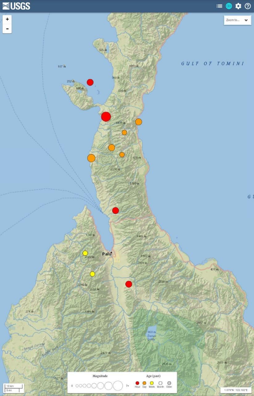
5. Recommendation:
The community is encouraged to remain calm and follow the instructions and information provided by local BPBD agents.
The community must remain vigilant against the occurrence of aftershocks whose energy is lower than that of the main earthquake.
The Emergency Response Team (TTD) of the Geological Agency (BG) will leave immediately at the site of the disaster.
Source : PVGHM.
Philippines , Kanlaon :
KANLAON VOLCANO BULLETIN 29 September 2018 08:00 A.M.
Kanlaon Volcano’s seismic monitoring network recorded three (3) volcanic earthquakes during the past 24 hours. Ground deformation data from continuous GPS measurements indicate pronounced inflation of the edifice since December 2017, signifying pressurization beneath the edifice. Sulfur dioxide (SO2) emission was measured at an average of 1105 tonnes/day on 01 September 2018.

Alert Level 2 status prevails over Kanlaon Volcano, which means that the volcano is undergoing a moderate level of unrest due to probable intrusion of magma at depth that may or may not lead to a magmatic eruption. The local government units and the public are strictly reminded that entry into the 4-kilometer radius Permanent Danger Zone (PDZ) is strictly prohibited due to the further possibilities of sudden and hazardous steam-driven or phreatic eruptions. Civil aviation authorities must also advise pilots to avoid flying close to the volcano’s summit as ejecta from any sudden phreatic eruption can be hazardous to aircraft.
DOST-PHIVOLCS is closely monitoring Kanlaon Volcano’s activity and any new development will be relayed to all concerned.
Source : Phivolcs
Aleutian Islands , Semisopochnoi :
51°55’44 » N 179°35’52 » E,
Summit Elevation 2625 ft (800 m)
Current Volcano Alert Level: WATCH
Current Aviation Color Code: ORANGE
Unrest continues at Semisopochnoi volcano. Intermittent seismic tremor has been detected on local seismic stations throughout the week. Early in the week, several of the most energetic seismic signals also produced signals detected on the Adak infrasound array located 257 km (159.5 miles) east of Semisopochnoi. These events were likely short-lived explosions, but produced no ash detectable in satellite imagery or reported by passing pilots. Cloudy conditions throughout the week have limited our ability to view the island and substantiate eruptive activity. The September 10 ash deposit indicates the potential for ash emissions coincident with the ongoing elevated seismicity. Thus Semisopochnoi volcano’s status remains at ORANGE/WATCH.
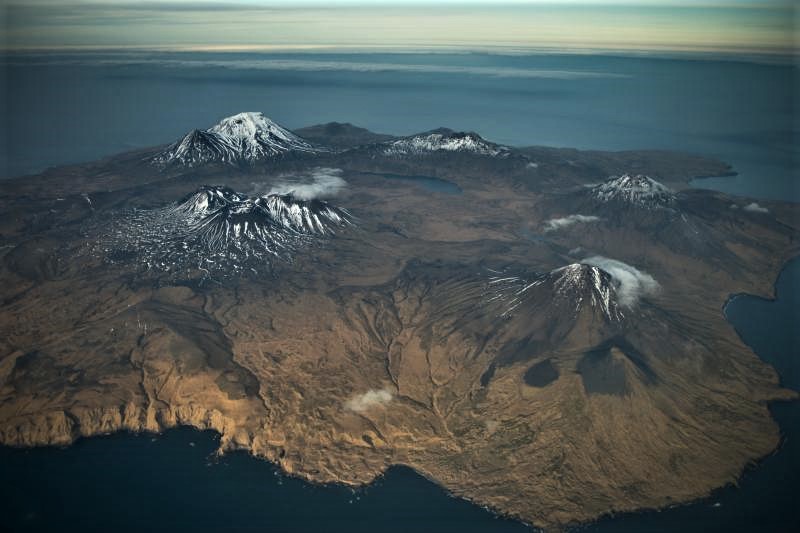
Semisopochnoi volcano, November 2012. Oblique aerial photograph courtesy of Roger Clifford. Semisopochnoi consists of a large caldera (about 8 km or 5 miles across) and a number of significant post-caldera composite cones. In this photo, the three closely-spaced snow dappled cones in the middle form the Cerberus complex. The large cone at lower right is called Sugarloaf, and this is thought to be the location of the most recent eruption in 1987. We know little in detail about this eruption.
Semisopochnoi is monitored with an on-island seismic network, and remotely by satellite and lightning sensors. An infrasound array on Adak Island may detect explosive emissions from Semisopochnoi with a 13 minute delay if atmospheric conditions permit.

Semisopochnoi, view of Cerberus from the south.
Remote Semisopochnoi volcano occupies the largest, young volcanic island in the western Aleutians. The volcano is dominated by an 8-km (5-mile) diameter caldera that contains a small lake and a number of post-caldera cones and craters. The age of the caldera is not known with certainty but is likely early Holocene. The last known eruption of Semisopochnoi occurred in 1987, probably from Sugarloaf Peak on the south coast of the island, but details are lacking. Another prominent, young post-caldera landform is Mount Cerberus, a three-peaked cone cluster in the southwest part of the caldera. The island is uninhabited and part of the Alaska Maritime National Wildlife Refuge. It is located 65 km (40 mi) northeast of Amchitka Island and 200 km (130 mi) west of Adak.
Source : AVO
Photo : Clifford, Roger , Jones, I. L.