May 10 , 2018.
Pu’u ‘Ō’ō / Kilauea , Hawai :
Eruption update:
Hawaiian Volcano Observatory confirms 2 new vents. Vent number 13 has opened near the intersection of Leilani Avenue and Kahukai Road and Vent number 14 near Kaupili St. and Leilani Avenue. Both have paused but continue to release hazardous gases. Since the onset of this eruption, a total of 14 fissures have emerged. The lava has covered 104 acres and 36 structures have been destroyed.
Tuesday, May 8, 2018, 11:18 PM HST (Wednesday, May 9, 2018, 09:18 UTC)
19°25’16 » N 155°17’13 » W,
Summit : 4091 ft (1247 m)
Current Volcano Alert Level: WARNING
Current Aviation Color Code: ORANGE
Lower East Rift Zone Eruption :
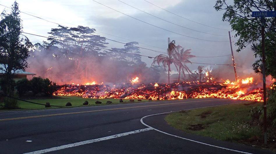
The intermittent eruption of lava in Leilani Estates in the lower East Rift Zone of Kīlauea Volcano continues. Activity today was focused on the northeast portion of the fissure area; two new fissure segments (13 and 14) broke ground between fissures 7 and 6. Fissure 13 cut across Leilani Street. By 5:00 pm, fissures 13 and 14 were inactive; late this evening geologists reported loud jetting and booming sounds, and some spattering, at fissure 13. At about 6:00 p.m. reports of booming sounds were reported in the vicinity of Black Sands Beach Subdivision. When HVO geologists arrived soon after, no such sounds were occurring.

Earlier this morning, geologists reported the widening of cracks of about 1 to 4 cm (0.4 to 1.6 in) of cracks on Highway 130 and Ali’ili road.
Rates of seismicity changed little throughout the day, but increased during the fissure activity in the afternoon. Gas emissions remain elevated in the vicinity of fissures.
HVO field crews successfully completed the installation of two new co-located seismometers and GPS receivers on the north and south sides of the East Rift Zone. Mahalo to landowners for allowing access and use of their property. HVO geologists will be in the area overnight to track and report to Hawaii County Civil Defense on the activity, and other scientists are tracking the volcano’s overall activity 24/7 using various monitoring data streams.
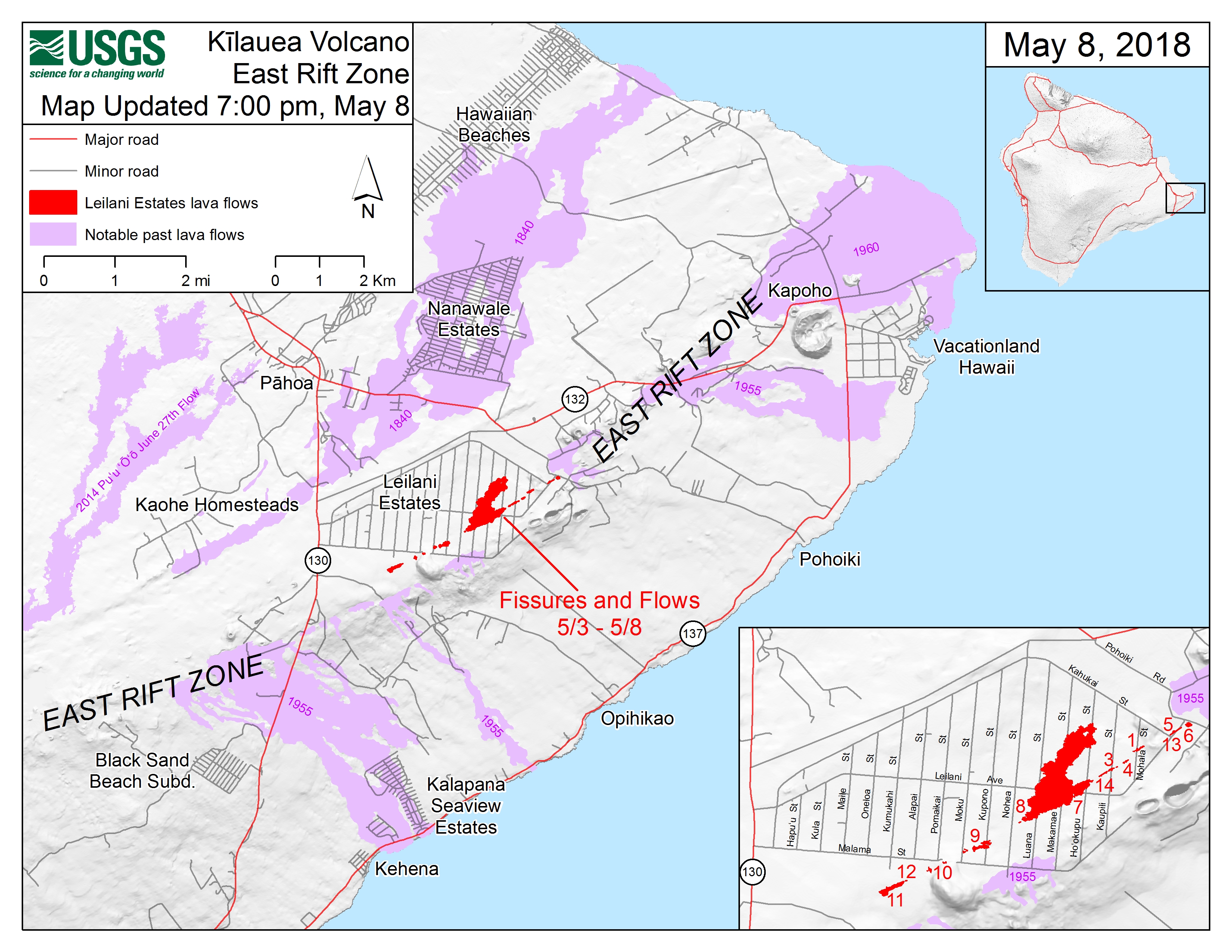
This map shows the locations of fissures and an ‘a’ā flow erupted since May 3 in the order that they occurred in Leilani Estates as of 5:30 p.m. HST, May 9. Note the area of heavy steaming from ground cracks that began earlier this afternoon, located west of Highway 130. The purple areas are lava flows erupted in 1840, 1955, 1960, and 2014-2015.
HVO/USGS Volcanic Activity Notice
Current Volcano Alert Level: WARNING
Current Aviation Color Code: ORANGE
Issued: Wednesday, May 9, 2018, 8:02 AM HST
Source: Hawaiian Volcano Observatory
Location: N 19 deg 25 min W 155 deg 17 min
Elevation: 4091 ft (1247 m)
Area: Hawaii
Volcanic Activity Summary:
The steady lowering of the lava lake in « Overlook crater » within Halemaʻumaʻu at the summit of Kīlauea Volcano has raised the potential for explosive eruptions in the coming weeks. If the lava column drops to the level of groundwater beneath Kīlauea Caldera, influx of water into the conduit could cause steam-driven explosions. Debris expelled during such explosions could impact the area surrounding Halemaʻumaʻu and the Kīlauea summit. At this time, we cannot say with certainty that explosive activity will occur, how large the explosions could be, or how long such explosive activity could continue.
Residents of the Kīlauea summit area should learn about the hazards of ashfall, stay informed of the status of the volcano and area closures, and review family and business emergency plans.
Remarks: HAZARDS
Primary hazards of concern should this activity occur are ballistic projectiles and ashfall.
BALLISTIC PROJECTILES
During steam-driven explosions, ballistic blocks up to 2 m (yards) across could be thrown in all directions to a distance of 1 km (0.6 miles) or more. These blocks could weigh a few kilograms (pounds) to several tons.
Smaller (pebble-size) rocks could be sent several kilometers (miles) from Halemaʻumaʻu, mostly in a downwind direction.
ASHFALL
Presently, during the drawdown of the lava column, rockfalls from the steep enclosing walls of the Overlook crater vent impact the lake and produce small ash clouds. These clouds are very dilute and result in dustings of ash (particles smaller than 2 mm) downwind.
Should steam-driven explosions begin, ash clouds will rise to greater elevations above ground. Minor ashfall could occur over much wider areas, even up to several tens of miles from Halemaʻumaʻu. In 1924, ash may have reached as high as 20,000 feet above sea level. Small amounts of fine ash from these explosions fell over a wide area as far north as North Hilo (Hakalau), in lower Puna, and as far south as Waiohinu.
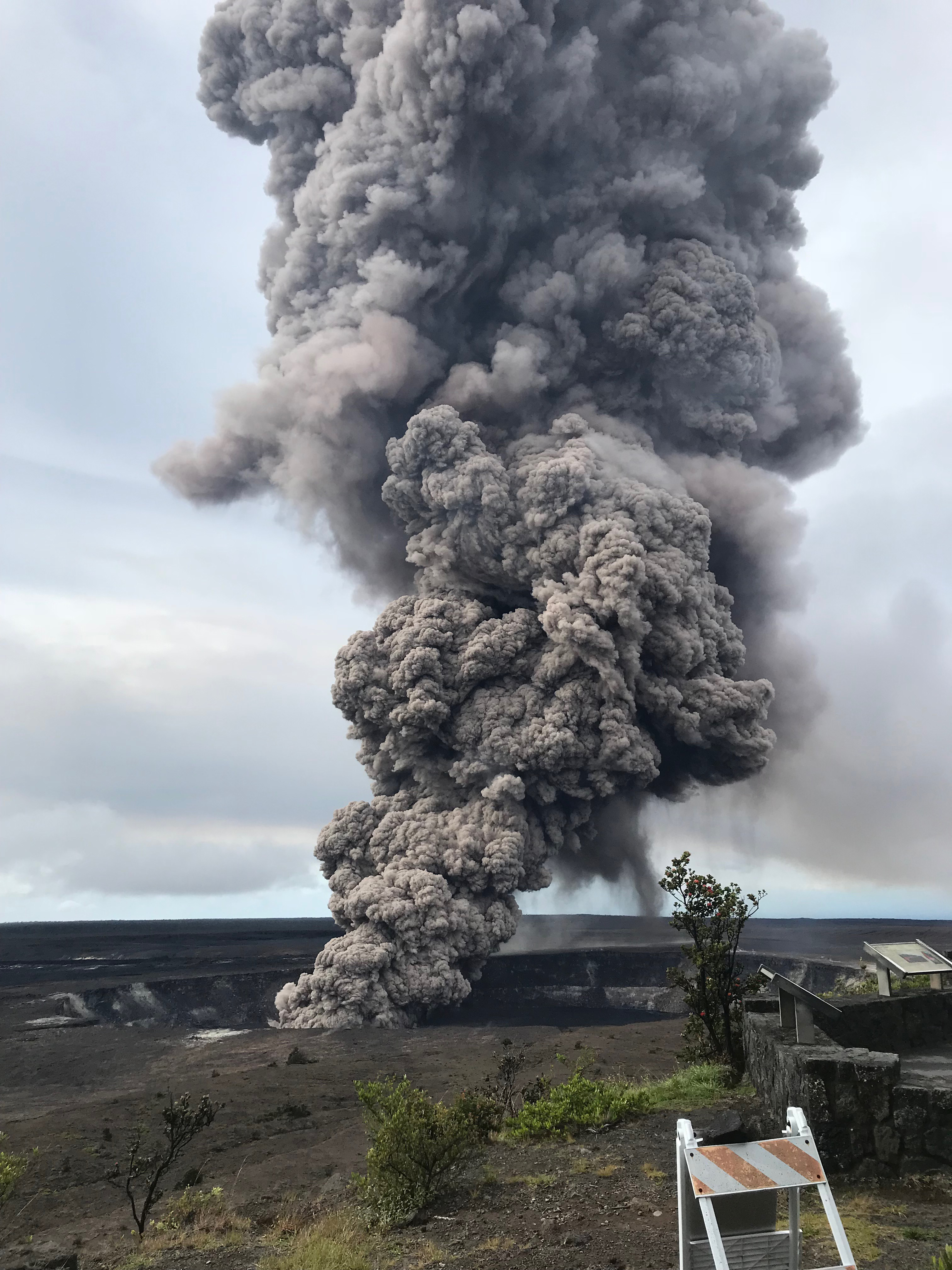
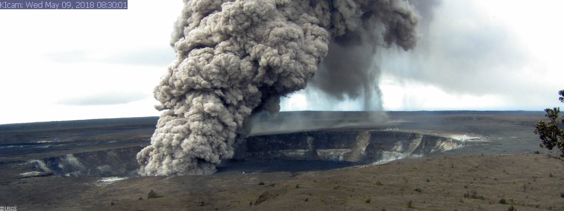
Ash column rises from the Overlook crater at the summit of Kīlauea Volcano. HVO’s interpretation is that the explosion was triggered by a rockfall from the steep walls of Overlook crater. The photograph was taken at 8:29 a.m. HST from the Jaggar Museum overlook. The explosion was short-lived. Geologists examining the ash deposits on the rim of Halema‘uma‘u crater found fresh lava fragments hurled from the lava lake. This explosion was not caused by the interaction of the lava lake with the water table. When the ash cleared from the crater about an hour after the explosion, geologists were able to observe the lava lake surface, which is still above the water table.
GAS
Gas emitted during steam-drive explosions will be mainly steam, but will include some sulfur dioxide (SO2) as well. Currently, SO2 emissions remain elevated.
WARNING TIME
Steam-driven explosions at volcanoes typically provide very little warning. Once the lava level reaches the groundwater elevation, onset of continuous ashy plumes or a sequence of violent steam-driven explosions may be the first sign that activity of concern has commenced.
BACKGROUND
Kīlauea’s lava lake began to drop on May 2, 2018. From its peak on May 2 to the most recent measurement at 9 pm on May 6, the lava lake surface dropped a total of more than 200 m (656 ft). The subsidence was at a relatively constant rate of about 2 meters (yards) per hour.
Measurements of subsidence have not been possible since May 6 because of thick fume and the increasing depth to the lava surface. However, thermal images indicate continued lowering of the lake surface since that time, consistent with deflationary tilt recorded at Kīlauea’s summit. Therefore, we infer that the lake surface continues to drop at roughly the same rate. So, while HVO cannot report exact depths of the receding lava lake, we can monitor the overall trend.
USGS and HVO scientists are monitoring changes at the summit 24/7 and watching for signs that hazardous conditions have increased, or may increase. HVO is working closely with Hawai’i Volcanoes National Park and Hawai’i County Civil Defense to respond to this situation.
Wednesday, May 9, 2018, 4:55 PM HST (Thursday, May 10, 2018, 02:55 UTC)
Lower East Rift Zone Eruption
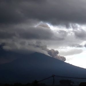
The intermittent eruption of lava in Leilani Estates in the lower East Rift Zone of Kīlauea Volcano continues. Visible activity this early afternoon was again focused on the northeast portion of the fissure area. Fissure 15 broke ground across Poihiki Road, generating a pahoehoe flow about 20 m (66 ft) long. During an overflight of the area about 3 p.m. HST, geologists observed a new steaming area uprift (west) of Highway 130. During a second overflight at 4:30 p.m., the area was still steaming.
Rates of motion increased late this morning on a GPS station 1.5 km (1 mile) southeast of Nanawale Estates. The direction of motion is consistent with renewed movement of magma in the downrift direction (to the northeast).
Rates of seismicity changed little throughout the day; located earthquakes were mostly uprift (west) of Highway 130. Gas emissions remain elevated in the vicinity of fissures.
Kīlauea Volcano Summit
Tiltmeters at the summit of Kīlauea Volcano continue to record the deflationary trend of the past week and the lava lake level continues to drop. At about 8:32 a.m. HST, a large rockfall from the steep crater walls into the retreating lake triggered an explosion that generated an ash column above the crater; the ash was blown toward the south-southwest. Rockfalls and explosions that produce ash columns are expected to continue.
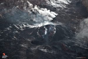
A 3D model of the Overlook crater was created from thermal images collected during an early afternoon helicopter overflight on May 8. Based on the 3D model, the lake level was about 295 m (970 feet) below the floor of Halema’uma’u Crater.
Earthquake activity in the summit remains elevated. Many of these earthquakes are related to the ongoing subsidence of the summit area and earthquakes beneath the south flank of the volcano.
Source : HVO.
Photos : HVO. Hawai news now .
Vidéo : HVO / Big Island Vidéo news.
Copahue , Chile :
During the reporting period, 96 seismic events classified as volcano tectonic (VT) associated with fracturing processes of rigid materials were recorded. The highest energy event had a local magnitude (ML) equal to 2.6 and was located 11.8 km in the northeast direction (NE) of the active crater El Agrio, at a depth of approximately 1 km.
Similarly 378 earthquakes associated with earthquakes related to fluid dynamics inside the volcano were recorded, cataloged as long period (LP) events, with a reduced displacement value (RDC) of up to 4, 4 cm2.
The series of bottom tremors at the Copahue reference station (2 km distance from the El Agrio crater) showed fluctuating trends between 0.6 and 3.4 cm 2 of reduced displacement (DRC), respectively considered low to moderate values, always with a dominant frequency band between 0.8 and 3.4 Hz.
IP cameras installed in the vicinity of the volcano recorded a constant degassing of the active crater (El Agrio) with a maximum height of 600 m (18 April). In addition, it is pointed out that since the early morning of April 23 there has been a steady glow in the crater El Agrio, a phenomenon that has not been recorded since January of this year.
From the data obtained from geodetic monitoring stations, we observed during the last month a stability of the deformation recorded similar to the values observed during the previous months.
According to data published by the Sulfur Dioxide (OMI) Ozone Monitoring Group, no sulfur dioxide (S02) emissions have been reported to the atmosphere in the area adjacent to the volcanic building (http: // www. http://so2.gsfc.nasa.gov/) and the National Environmental Satellite Information and Data Service (NESDIS) (http://sateDsanoine.nesdis.noaa.gov).
No thermal warnings were reported in the area associated with the volcanic structure in the second half of the month, based on data processed by the Medium Infrared Observation of Volcanic Activity (MIROVA) (http: / /www.mirovaweb.it/) and near real-time data (MODVOLC).
The level of volcanic alert remains at the level:
YELLOW LEVEL: Changes in the behavior of volcanic activity – likely time for an eruption: weeks / months.
Observation: It is recommended to apply precautionary access restrictions in an area close to the crater with a radius of 1 kilometer around the active crater.
Source : Sernageomin
Piton de la Fournaise , La Réunion :
Activity Bulletin from Wednesday, May 9, 2018 at 17:00 (local time).
The eruption started on April 27, 2018 at 23:50 local time continues. The intensity of the volcanic tremor (an indicator of surface eruptive intensity) has remained relatively stable over the past 24 hours (Figure 1).
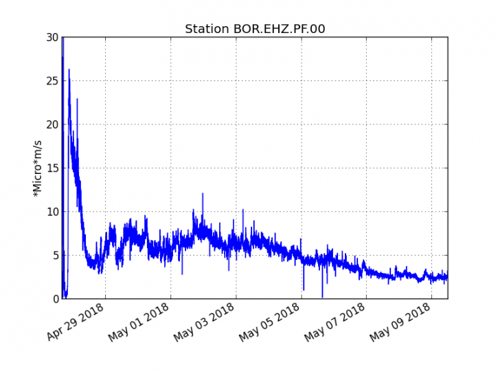
Figure 1: Evolution of the RSAM (Indicator of Volcanic Tremor and Eruption Intensity) between 20:00 (16:00 UTC) April 27 and 16:00 (12:00 UTC) May 9 at the BOR Seismic Station (located at the top) . (© OVPF / IPGP)
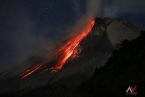
The activity is still mainly focused on the central cone (Figure 2) with lava projections of low height (less than 10 m above the cone) and a lava flow mainly tunnel. Resurgences are always visible 1 km downstream of the cone.

The treatment of aerial images by stereophotogrammetry made it possible to follow in recent days the evolution of the main cone. It has risen from 18m to 21m in height (between May 3rd and 5th) and the eruptive mouth at the top of the cone has closed slightly, from 30 × 25m wide on May 3rd against 25 × 25m on 5th May. may. The diameter of the cone at its base is of the order of 100 m.
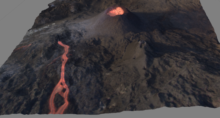
3D representation of the eruptive site on 03/05/2018 performed by stereophotogrammetry (© images Charly Rosary and OVPF / IPGP treatment)
– The surface flows estimated from the satellite data, via the HOTVOLC platform (OPGC – Clermont Ferrand), recorded today were always between 1 and 2.5 m3 / s.
– No significant deformation is recorded.
– No volcano-tectonic earthquake has been recorded during the last 24 hours under the Piton de la Fournaise building.
Alert level: Alert 2-2 – Eruption in the Enclos.
Source : OVPF
Sangeangapi , Indonésia :
VOLCANO OBSERVATORY NOTICE FOR AVIATION – VONA.
Issued: May 09 , 2018.
Volcano: Sangeangapi (264050)
Current Aviation Colour Code: YELLOW
Previous Aviation Colour Code: yellow
Source: Sangeangapi Volcano Observatory
Notice Number: 2018SAN02
Volcano Location: S 08 deg 12 min 00 sec E 119 deg 04 min 12 sec
Area: West Nusa Tenggara, Indonesia
Summit Elevation: 6237 FT (1949 M)
Volcanic Activity Summary:
Gas emission plume was observed at 10h07 UTC (18h07 LT)
Volcanic Cloud Height:
Best estimate of ash-cloud top is around 13274 FT (4148 M) above sea level, may be higher than what can be observed clearly. Source of height data: ground observer.
Other Volcanic Cloud Information:
The plume is moving to west.
Remarks:
Seismic activity is characterized by low frequency earthquakes.
Sangeang Api volcano, one of the most active in the Lesser Sunda Islands, forms a small 13-km-wide island off the NE coast of Sumbawa Island. Two large trachybasaltic-to-tranchyandesitic volcanic cones, 1949-m-high Doro Api and 1795-m-high Doro Mantoi, were constructed in the center and on the eastern rim, respectively, of an older, largely obscured caldera. Flank vents occur on the south side of Doro Mantoi and near the northern coast. Intermittent historical eruptions have been recorded since 1512, most of them during in the 20th century.
Source : Magma Indonesia , GVP.
Photo : G Vitton