May 07 , 2018.
Pu’u ‘Ō’ō / Kilauea , Hawai :
19°25’16 » N 155°17’13 » W,
Summit Elevation 4091 ft (1247 m)
Current Volcano Alert Level: WARNING
Current Aviation Color Code: ORANGE
Summary:
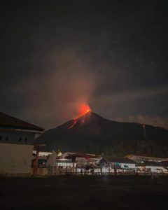
Active eruption of lava and gas continues along Kīlauea Volcano’s lower East Rift Zone within the Leilani Estates subdivision. Since late last evening, fissure eruptions have been continuous, and a lava flow has advanced northward about 0.9 km (0.6 miles). Deflationary tilt at the summit of the volcano continues and the lava lake level continues to drop. There is no active lava in the Puʻu ʻŌʻō area. Aftershocks from Friday’s magnitude-6.9 earthquake continue and more should be expected, with larger aftershocks potentially producing rockfalls and associated ash clouds above Puʻu ʻŌʻō and Halemaʻumaʻu crater. Seismicity at Kīlauea’s summit remains elevated.
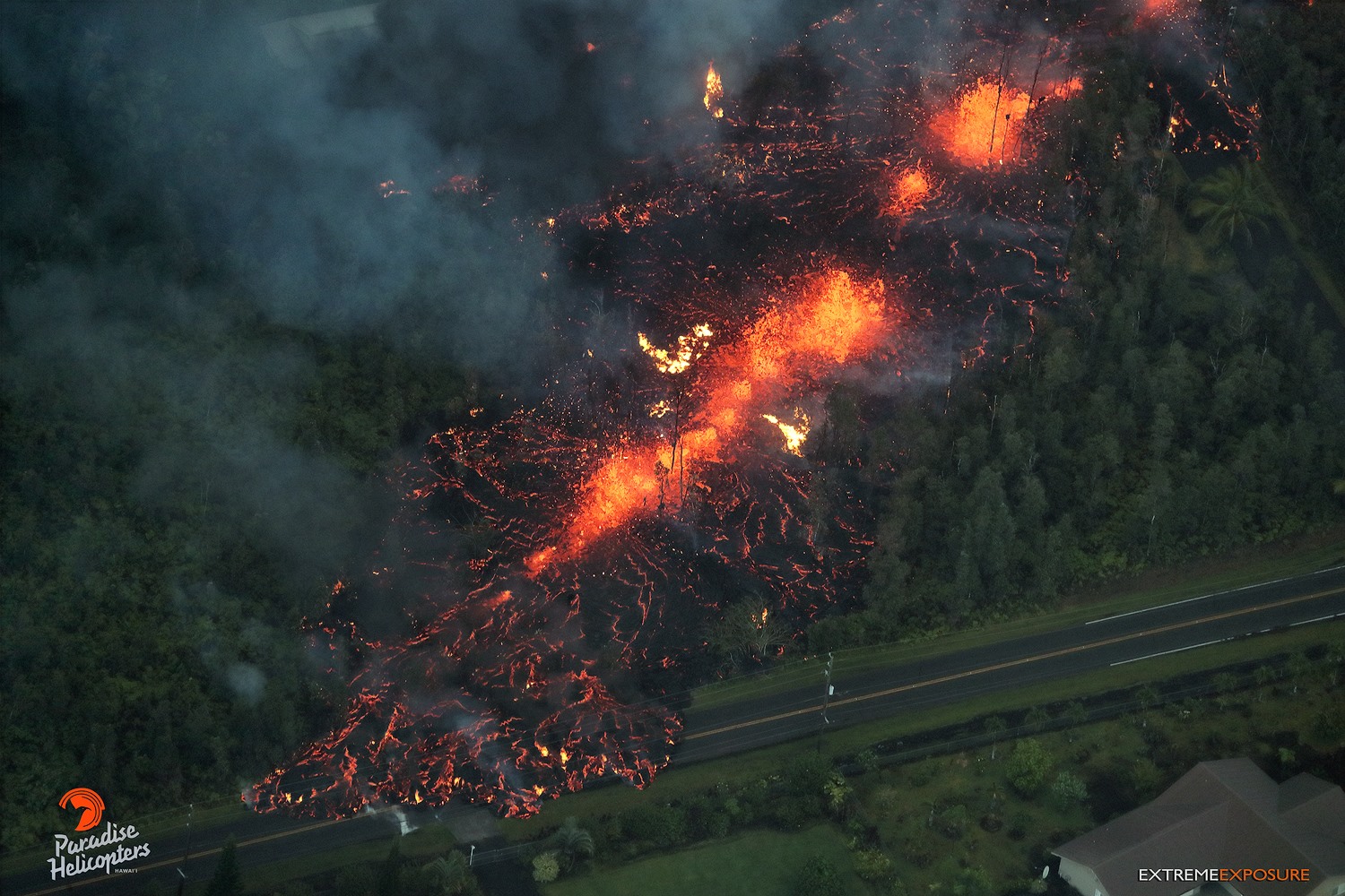
Fissure 7 began yesterday morning around dawn and was active for several hours. At the peak of its activity, large bubble bursts occurred at one spot (lower left) in the fissure while spattering was present in other portions. A short lava flow was erupted from the fissure around 8 a.m. HST, moving northeast and crossing Hookupu St.
Lower East Rift Zone Observations
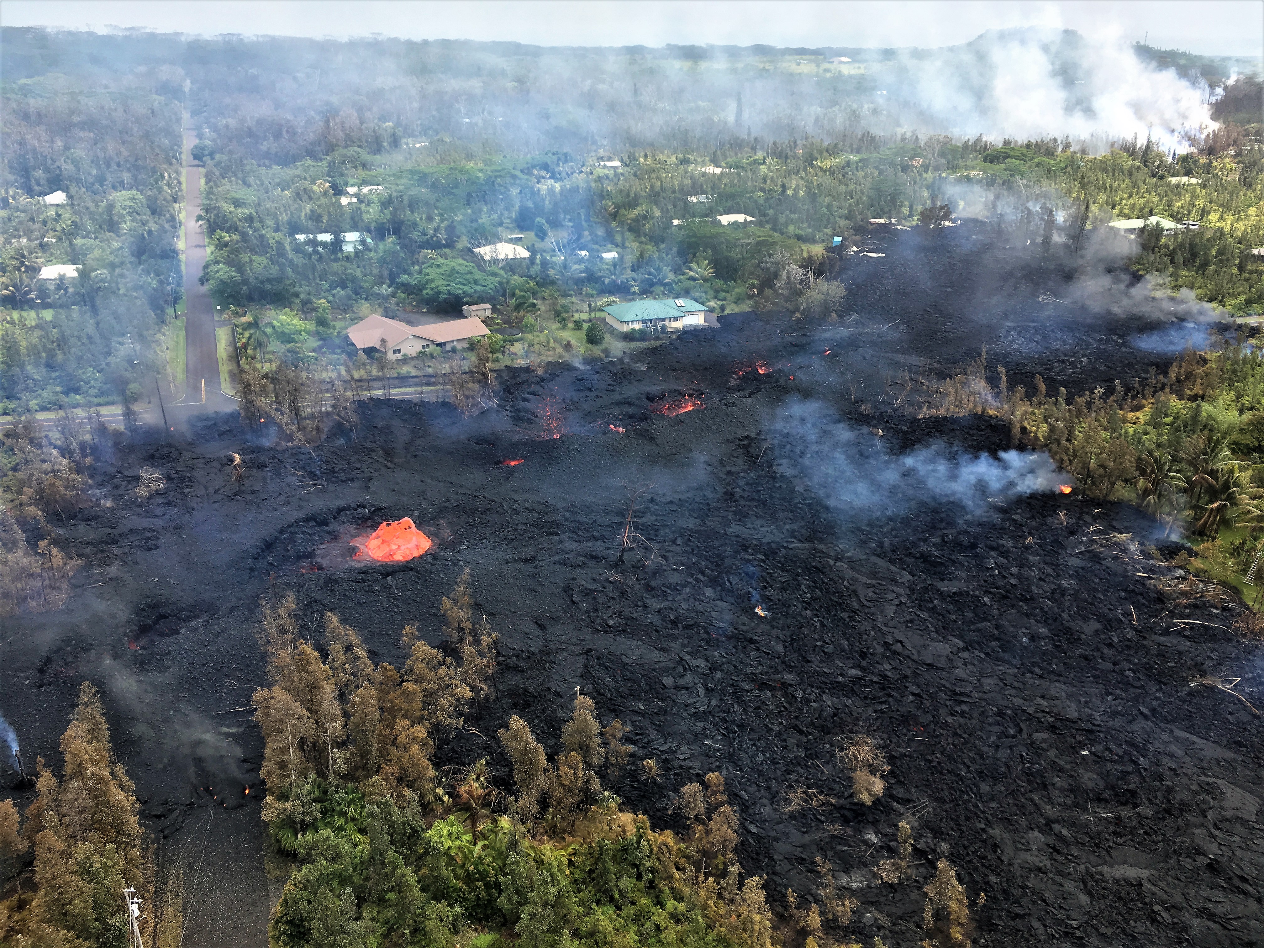
The eruption in the lower East Rift Zone within Leilani Estates continues with continuous activity from one or two fissure segments since late last evening. A lava flow advanced northward from fissure 8 beginning about 5 a.m. HST; the flow advanced north-northeast about 0.9 km (0.6 miles) by 10 a.m., HST.
In the past 12 hours, deformation of the ground in the area suggests a pause in magma accumulation in the distal part of the intrusion.
Overall seismicity has not changed significantly overnight. Earthquakes continue at a diminished rate compared to the past couple of days, and the stations nearest to the erupting fissures record fluctuating amplitude levels that correspond to fissure eruptive activity.
Summit Observations:
Tiltmeters at the summit continue to record a deflationary trend of the past week and the summit lava lake level continues to drop. The lake level has dropped about 35 m (115 ft) during the past 24 hours based on a continuously recording laser range-finder instrument on the crater rim. Elevated summit sulfur dioxide emission rates persist.
Elevated earthquake activity in the summit area is continuing following Friday’s magnitude-6.9 earthquake and as the summit area continues deflating.

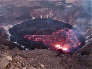
Puʻu ʻŌʻō Observations:
A tiltmeter on the Puʻu ʻŌʻō cone continues to record the deflationary pattern that followed collapse of the crater floor on April 30. Rockfalls from the steep crater walls will likely continue to collapse intermittently, producing small ashy plumes. The 61g lava flow is no longer active.
Hazard Analysis:
Continued eruptive activity (fluctuating and intermittent) in the lower East Rift Zone is likely. A slow-moving lava flow is advancing northward from the erupting fissure 8; the flow has advanced about 0.9 km (0.6 miles).
Areas downslope of erupting fissures are at risk of lava inundation. The general area of Leilani Estates remains at the greatest risk. However, as the eruption progresses, other areas of the lower East Rift Zone may also be at risk.

High levels of volcanic gas including sulphur dioxide are being emitted from the fissure vents. In addition, smoke from burning houses and burning asphalt is a health concern and should be avoided.
As the lava lake level inside Halemaʻumaʻu drops, rockfalls from the enclosing walls may increase in frequency prompting explosions of spatter from the lake onto the nearby crater rim and lofting plumes of ash. Dustings of ash from these events can occur downwind.
Additional aftershocks from the magnitude-6.9 earthquake are expected and some may be strong. Residents are advised to review earthquake preparedness by consulting available resources .
Residents of the Puna District should remain alert, review individual, family, and business emergency plans, and watch for further information about the status of the volcano.
A message from COUNTY OF HAWAII
This is a Civil Defense update for Sunday May 6, 2018 at 8:15 AM.
Hawaiian Volcano Observatory confirms 2 more fissures emerged between Leilani and Malama Street near Luana and Kupono Street last night, bringing the total number of fissures to 9 at this time. Active venting of lava and hazardous fumes continues between Mohala and Pomaika’i Street.
It is confirmed that at this time, at least 9 homes have been destroyed.
Due to the eruption, the following are issued:
Conditions permitting, Leilani Estates residents with property between Highway 130 and Maile Street will be allowed to enter the subdivision to complete evacuation of pets, medicine, and vital documents left behind between the hours of 8 AM to 6 PM.
Residents should retrieve their items expeditiously so others may go in after them.
Be aware of the very unstable conditions of air quality and of the roads. You will be required to leave the area if conditions become hazardous.
Residents will be required to provide identification and proof of residency in Leilani Subdivision. Primary Police checkpoint is established at Highway 130 and 132. A secondary checkpoint is at Highway 130 and Leilani Street.
Leilani residents entering must be on the alert for elevated levels of Sulfur Dioxide, wildfire, and volcanic eruption. People with respiratory problems are especially vulnerable.
No access is allowed at this time for residents of Lanipuna Gardens due to dangerous volcanic gases.
Source : HVO
Photos : HVO , Bruce Omori , Ann Kalber , AVCAN.
Video : Big Island Video news .
Pacaya , Guatemala :
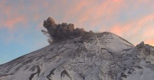
Pacaya volcano shows strong explosions in Guatemala
Tourists are advised not to stay on the plateau, an open area near the crater, because of the risk of lava flows and falling rocks.
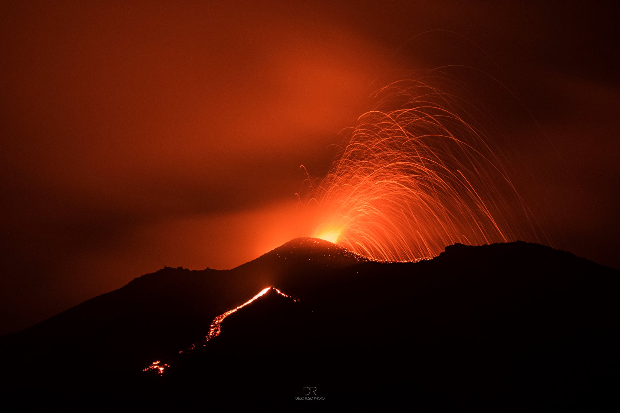
The Guatemalan authorities have been monitoring the Pacaya volcano near the capital since Saturday after reporting heavy explosions that caused earthquakes in neighboring communities, the agency in charge of civil protection said.
The volcano, located 20 km south of Guatemala City, began to increase its activity a week ago, but between Friday and Saturday it shows strong explosions « up to four kilometers around the volcano, » said Julio Sánchez , spokesman of the National Coordinating Committee. for disaster reduction (Conrad).
The official explained that they were communicating with the leaders of seven communities of the municipality of San Vicente Pacaya, located on the slopes of the 2552-meter high volcano, with a view to the possibility of an increase in « effusive activity « .
He added that at this moment, the explosions reach 150 meters above the crater, although no rain of ash is reported.
He also recommended tourists not to stay on the plateau, an open area near the crater, because of the danger of lava flows and falling rocks.
The Pacaya volcano had recorded between May 27 and May 28, 2010 a powerful eruption that had caused the death of a television reporter for being exposed to toxic gases. He also left thousands homeless and forced the closure of the capital’s international airport for five days
Source : Teletica , Insivumeh
Photo : Diego Rizzo Photo via Sherine France .
Piton de la Fournaise , La Réunion :
Activity bulletin of May 6, 2018 at 15:00 (local time).
The eruption started on April 27, 2018 at 23:50 local time continues. The intensity of the volcanic tremor (indicator of eruptive intensity at the surface) has decreased very slightly since 48 hours (Figure 1).
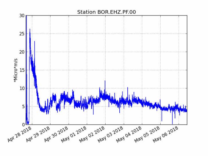
Evolution of RSAM (indicator of volcanic tremor and intensity of eruption) between 20:00 (16:00 UTC) April 27 and 15:00 (11:00 UTC) May 6 on the seismic station BOR (located at the top). (IPGP / OVPF)
– The surface flows estimated from the satellite data, via the HOTVOLC platform (OPGC – Clermont Ferrand), recorded today were between 1 m3 / s and 2 m3 / s.
– A very slight deflation (deflation) of the volcano continues to be recorded on the deformation sensors of the OVPF. This means that the volume of magma coming out of the reservoir to feed the eruption is greater than the volume of magma that replenishes it.
– No volcano-tectonic earthquake has been recorded in the last 24 hours under the Piton de la Fournaise building.
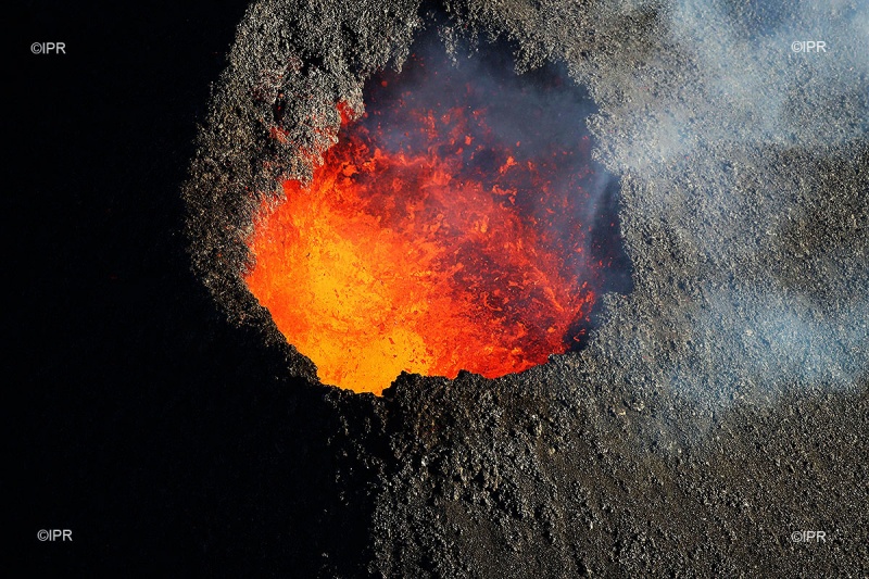
– A team from the Observatory on the ground reported at 14:30 (local time) an activity concentrated on the central vent (as in previous days), lava-only flows and sporadic projections. In addition, some small fires have been identified at the foot of the rampart west of Piton Bert.
Source : OVPF
Photo : Imazpress
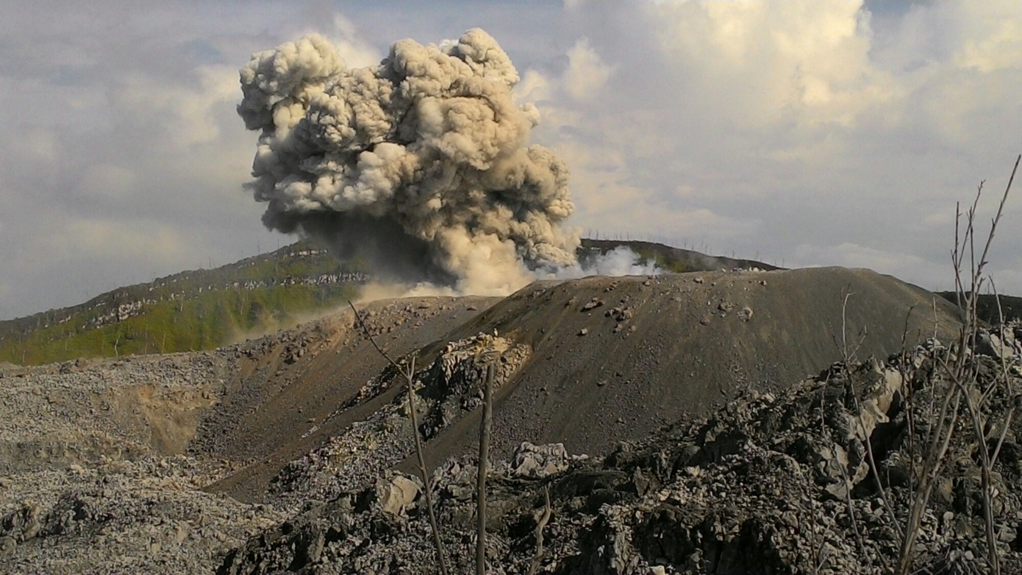
Ibu , Indonesia :
Level II Activity Level (WASPADA). G. IBU (1340 m above sea level) has been erupting since 2008.
Since yesterday until this morning visually the peak of the volcano can be observed until it is covered with fog. The explosion / emission column is observed in a white to gray color, moderate to medium intensity, rising 300-600 m above the peak. The wind is blowing from weak to medium north and east.
Through the seismographs, dated May 6, 2018, it was recorded:
81 earthquakes of eruption.
74 earthquakes of emission.
26 avalanche earthquakes.
Recommendations:
Communities around G. Ibu and visitors / tourists should not climb and approach within 2 km, with a 3.5 km sectoral expansion towards the opening in the northern part of the active crater of G. Ibu.
VONA:
VOLCANO OBSERVATORY NOTICE FOR AVIATION – VONA.
Issued: May 04 , 2018.
Volcano: Ibu (268030)
Current Aviation Colour Code: ORANGE
Previous Aviation Colour Code: orange
Source: Ibu Volcano Observatory
Notice Number: 2018IBU04
Volcano Location: N 01 deg 29 min 17 sec E 127 deg 37 min 48 sec
Area: North Maluku, Indonesia
Summit Elevation: 4240 FT (1325 M)
Volcanic Activity Summary:
Eruption with volcanic ash cloud at 21h22 UTC (06h22 local).
Volcanic Cloud Height:
Best estimate of ash-cloud top is around 6160 FT (1925 M) above sea level, may be higher than what can be observed clearly. Source of height data: ground observer.
Other Volcanic Cloud Information:
Ash cloud moving to North.
Remarks:
Eruption and ash emission is continuing.
Sources : VSI , Magma .
Photo : John Massolo – WordPress.com