May 05 , 2018.
Pu’u ‘Ō’ō / Kilauea , Hawai :
The HVO posts are given in the order of their publication, from the most « old » to the most recent.
Thursday, May 3, 2018, 10:13 PM HST (Friday, May 4, 2018, 08:13 UTC)
19°25’16 » N 155°17’13 » W,
Summit Elevation 4091 ft (1247 m)
Current Volcano Alert Level: WARNING
Current Aviation Color Code: ORANGE
The eruption in the Leilani Estates subdivision in the lower East Rift Zone of Kīlauea Volcano that began in late afternoon ended by about 6:30 p.m. HST. Lava spatter and gas bursts erupted from the fissure for about two hours, and lava spread a short distance from the fissure, less than about 10 m (33 ft).
At this time, the fissure is not erupting lava and no other fissures have erupted.
HVO geologists are working near the fissure overnight to track additional activity that may occur, and other scientists are closely tracking the volcano’s overall activity.
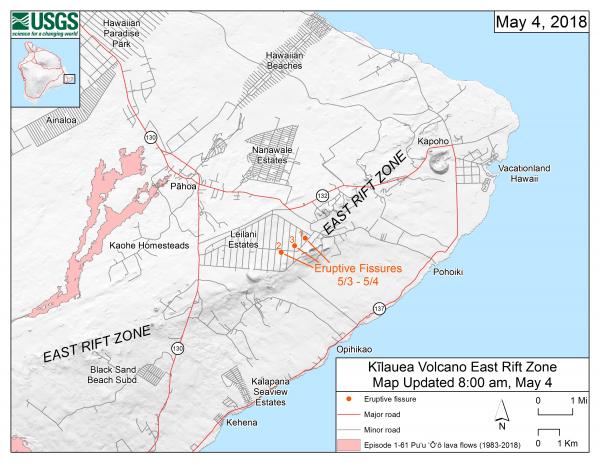
This map shows the locations, mapped by USGS-HVO scientists, of the three eruptive fissures in the order that they occurred in the Leilani Estates Subdivision as of 8:00 a.m. HST today (May 4). The fissures are jetting copious amounts of sulfur dioxide gas, which should be avoided. Spatter is also being emitted, but lava flows are not extending far from the active fissures. The eruption remains dynamic, which means that changes could occur with little notice. Updated maps will be posted on this webpage as new information becomes available.
Recent Observations
Geologists reported this evening that the presence of sulfur gas is quite noticeable around the fissure, typical of active and recently active fissures. The concentration of sulfur dioxide gas is high within tens of meters (yards) of the fissure.
Lava flows did not advance more than about 10 m (33 ft) from the fissure. The flows are no longer active.
At this time, no other fissures have erupted from along the rift zone.
Tiltmeters at Kīlauea’s summit continue to record deflationary tilt and the lava lake level has dropped about 37 m (121 ft) in the past 24 hours.
Seismic activity has not changed significantly during the day or since the brief fissure eruption.
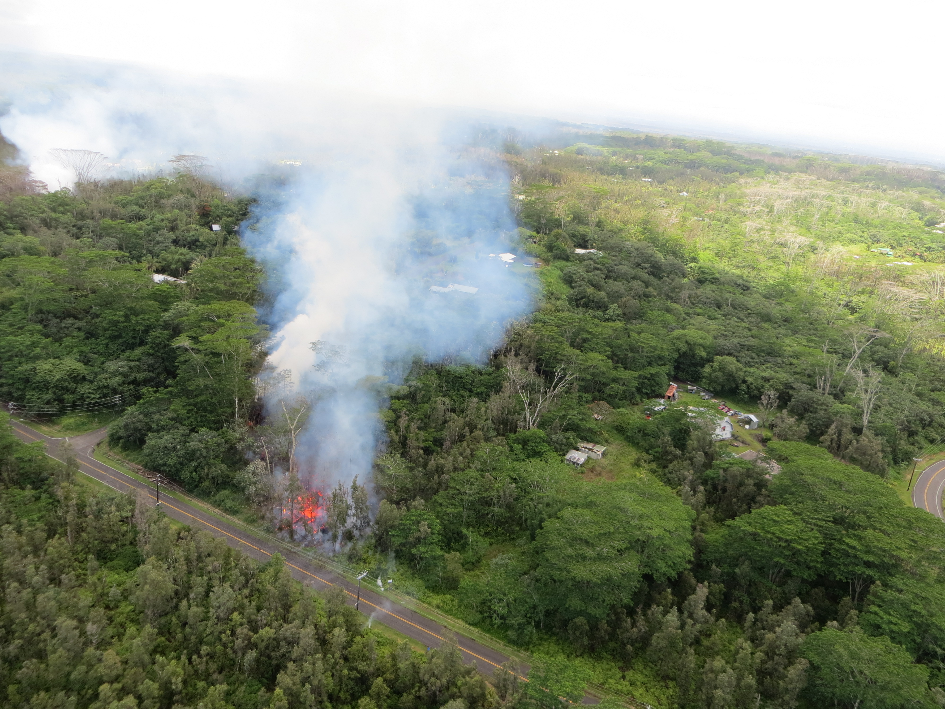
An eruption has commenced in the Leilani Estates subdivision in the lower East Rift Zone of Kīlauea Volcano. White, hot vapor and blue fume emanated from an area of cracking in the eastern part of the subdivision. Spatter began erupting shortly before 5:00 p.m. HST. Lava was confirmed at the surface in the eastern end of the subdivision, in the areas of Mohala and Leilani Streets. According to the Hawai‘i County Civil Defense update at 5:40 p.m., all residents in Leilani Estates and Lanipuna Gardens Subdivsions are required to evacuate.
Hazard Analysis:
The opening phases of fissure eruptions are dynamic and uncertain. Additional erupting fissures and new lava outbreaks may occur. It is not possible at this time to say when and where new vents may occur.
Areas downslope of an erupting fissure or vent are at risk of lava inundation. At this time, the general area of the Leilani subdivision appears at greatest risk.
Friday, May 4, 2018, 7:45 AM HST (Friday, May 4, 2018, 17:45 UTC)
Summary:
An eruption is in progress along Kīlauea Volcano’s lower East Rift Zone. Since late afternoon May 3, at least three small fissure vents have opened in Leilani Estates subdivision in the lower Puna district. At this time, activity consists mostly of vigorous lava spattering. Additional outbreaks in the area are likely. Deflationary tilt at the summit of the volcano continues and the lava lake level continues to drop.
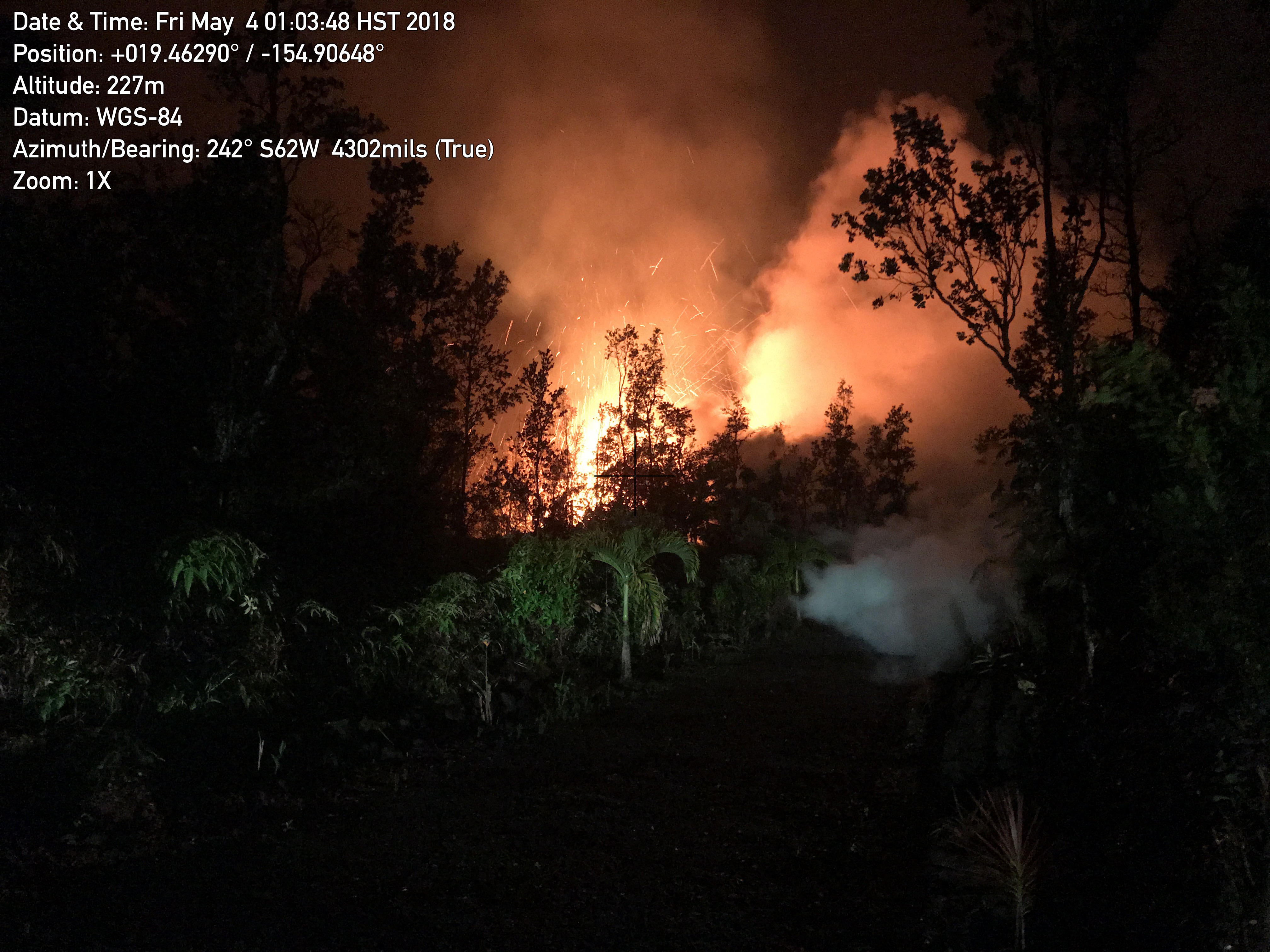
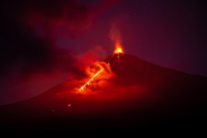
A new lava fissure (Fissure 2) commenced around 1:00 am HST on Kīlauea Volcano’s lower East Rift Zone on Makamae and Leilani Streets in the Leilani Estates subdivision. Spatter was being thrown roughly 30 m (about 100 ft) high at the time of this photo. Copious amounts of sulfur dioxide gas, which should be avoided, is emitted from active fissures. The eruption is dynamic and changes could occur with little warning.
Lower East Rift Zone:
The first outbreak of lava occurred late in the afternoon of May 3 following days of increased earthquake activity and ground deformation. As of this morning, three separate fissures have opened in the eastern portion of Leilani Estates. Each outbreak has been preceded by ground cracking and strong gas emission. Activity consists primarily of vigorous spattering of lava and development of very short lava flows that have yet to travel more than a few tens of yards from the vent. Earthquake activity in the area remains elevated and ground deformation is continuing. High levels of volcanic gas are reported around the fissure vents.
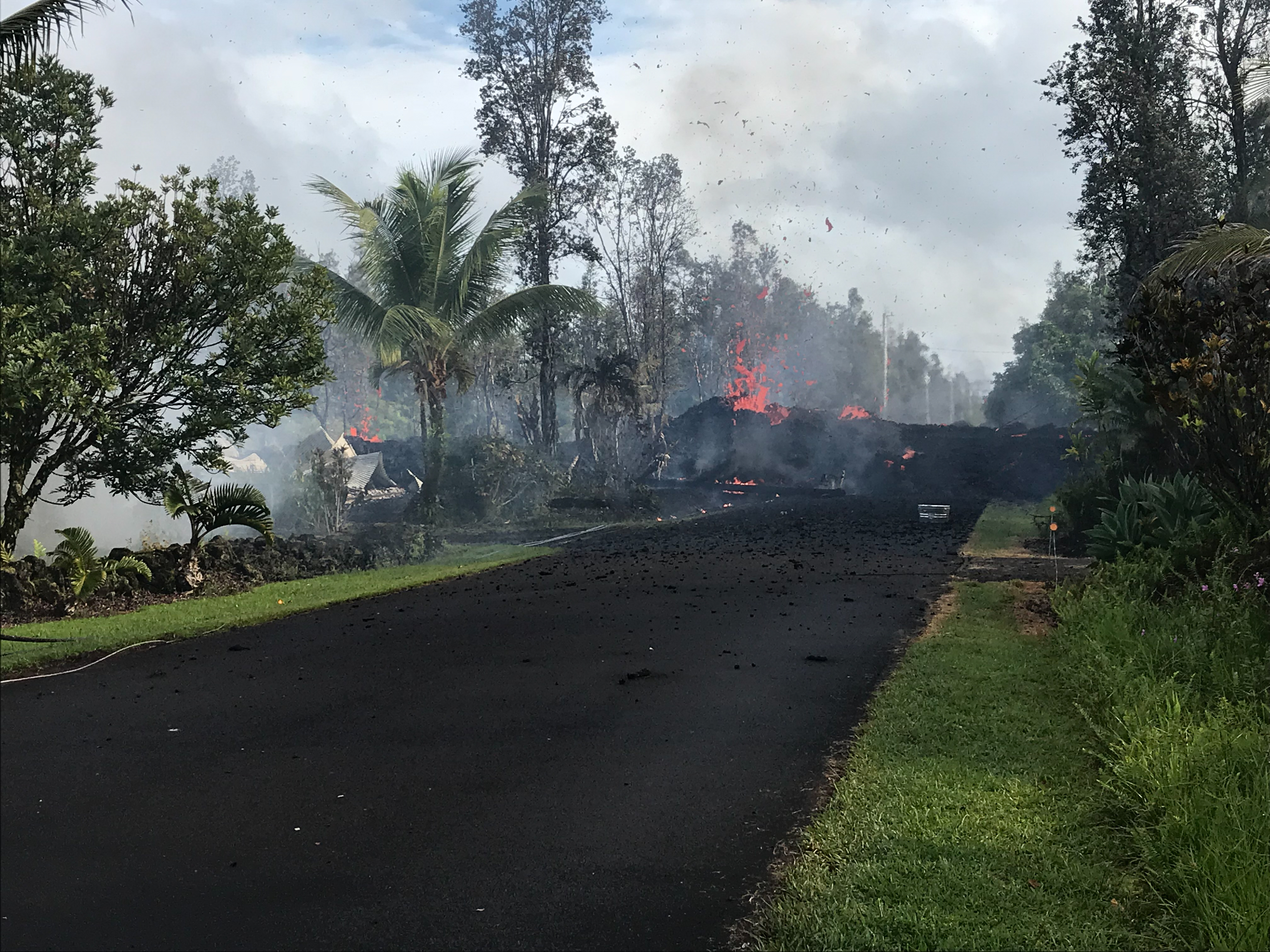
Fissure 3 at Leilani and Kaupili Streets in Leilani Estates subdivision at 8:07 a.m. HST today. Lava on the road was approximately 2 m (about 2 yd) thick.
Residents of the Puna District to remain alert, review individual, family, and business emergency plans, and watch for further information about the status of the volcano. Hawaii County Civil Defense messages regarding conditions, warning, and evacuations may be found at http://www.hawaiicounty.gov/active-alerts/.
Summit Observations:
Deflationary tilt at the summit continues. In concert, the summit lava lake is dropping. Tremor amplitude is fluctuating with lava lake spattering. Elevated summit sulfur dioxide emission rates persist. Gas emissions remain elevated.
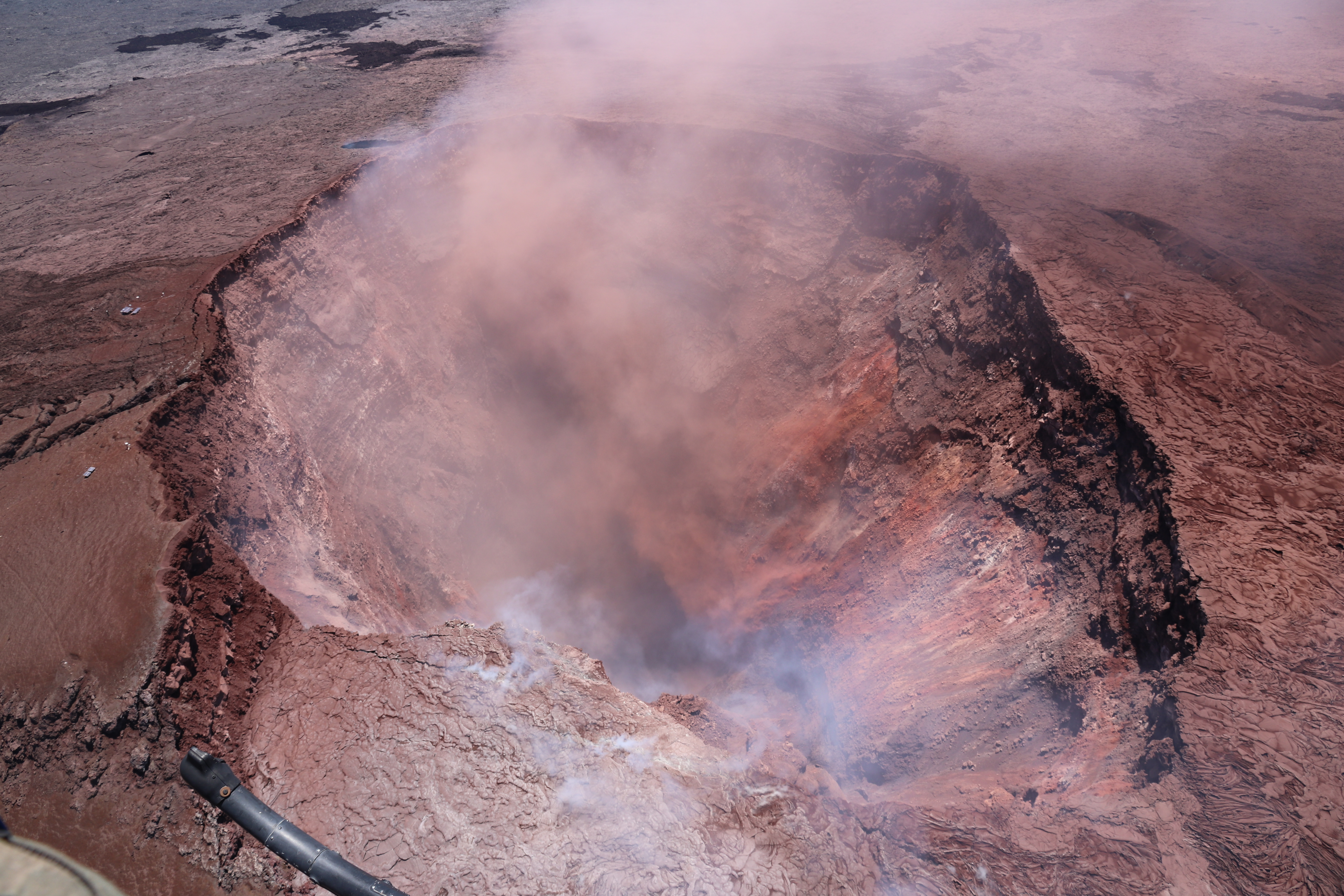
After a long period of rain and low clouds, improved weather and high clouds today allowed good airborne observations of the collapse crater in Pu‘u ‘Ō‘ō. This photo looks to the east, and shows the deep collapse crater formed on Monday, April 30, when magma beneath Pu‘u ‘Ō‘ō drained. For scale, the crater is about 250 meters (820 feet) wide.
Puʻu ʻŌʻō Observations:
Seismicity remains elevated at Puʻu ʻŌʻō but tiltmeters near the cone show no significant deformation overnight. During fieldwork at Puʻu ʻŌʻō yesterday, no lava activity was observed in the area. The 61g lava flow is no longer being fed. The summit crater of the cone continues to collapse intermittently producing small plumes of ash; yesterday there were several episodes of ash emission in response to collapse, including immediately after the nearby M5.0 earthquake.
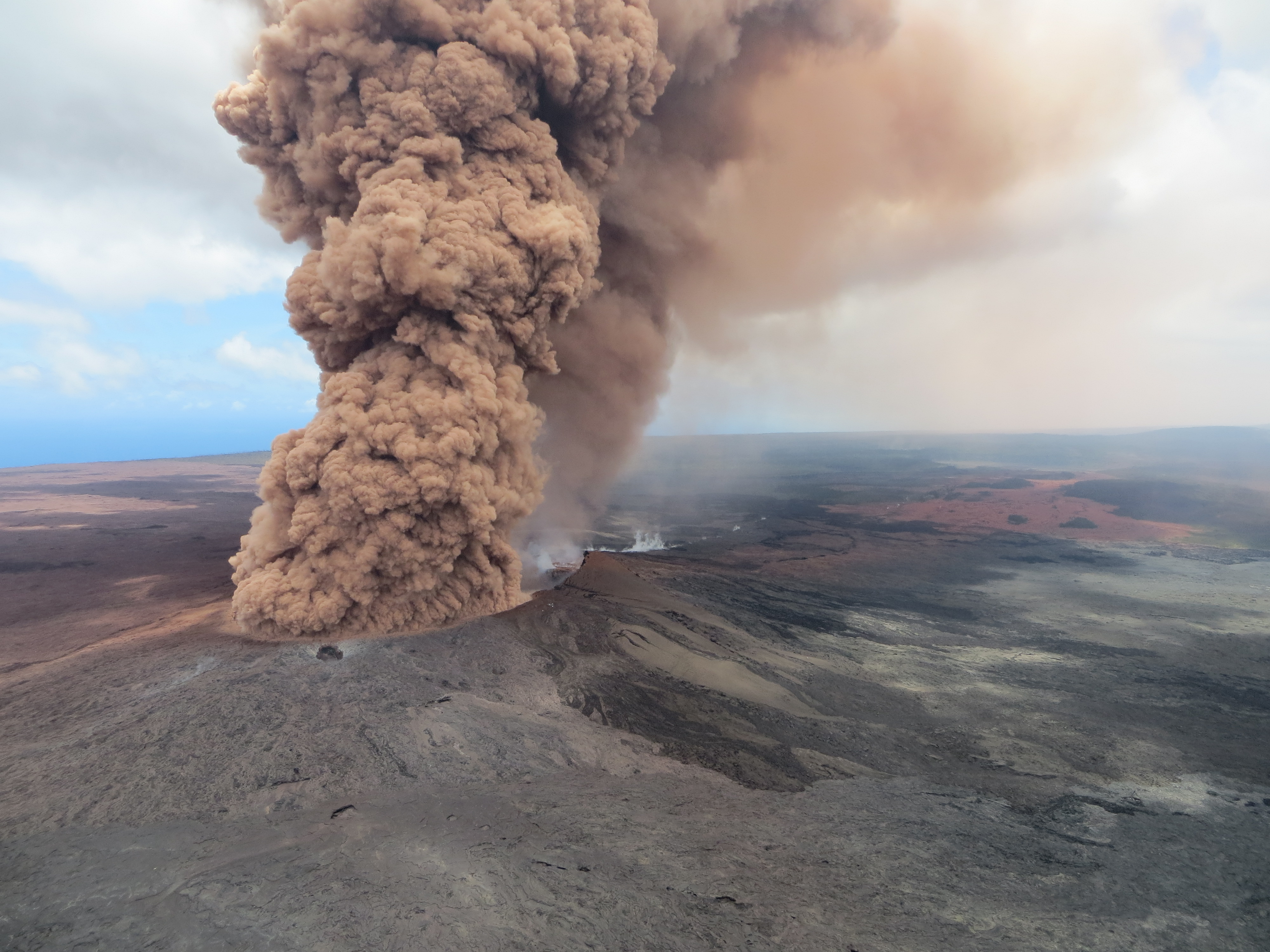
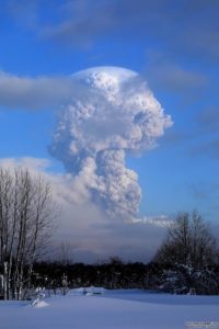
At 12:46 p.m. HST, a column of robust, reddish-brown ash plume occurred after a magnitude 6.9 South Flank of Kīlauea earthquake shook the Big Island of Hawai‘i.
Friday, May 4, 2018, 4:04 PM HST (Saturday, May 5, 2018, 02:04 UTC)
Eruption of lava in the Leilani Estates subdivision in the lower East Rift Zone of Kīlauea Volcano continues. Several additional eruptive fissures or vents – each several hundred yards long – have opened over the past day. No significant lava flows have yet formed. Spatter and lava are accumulating primarily within a few tens of yards of the vent.
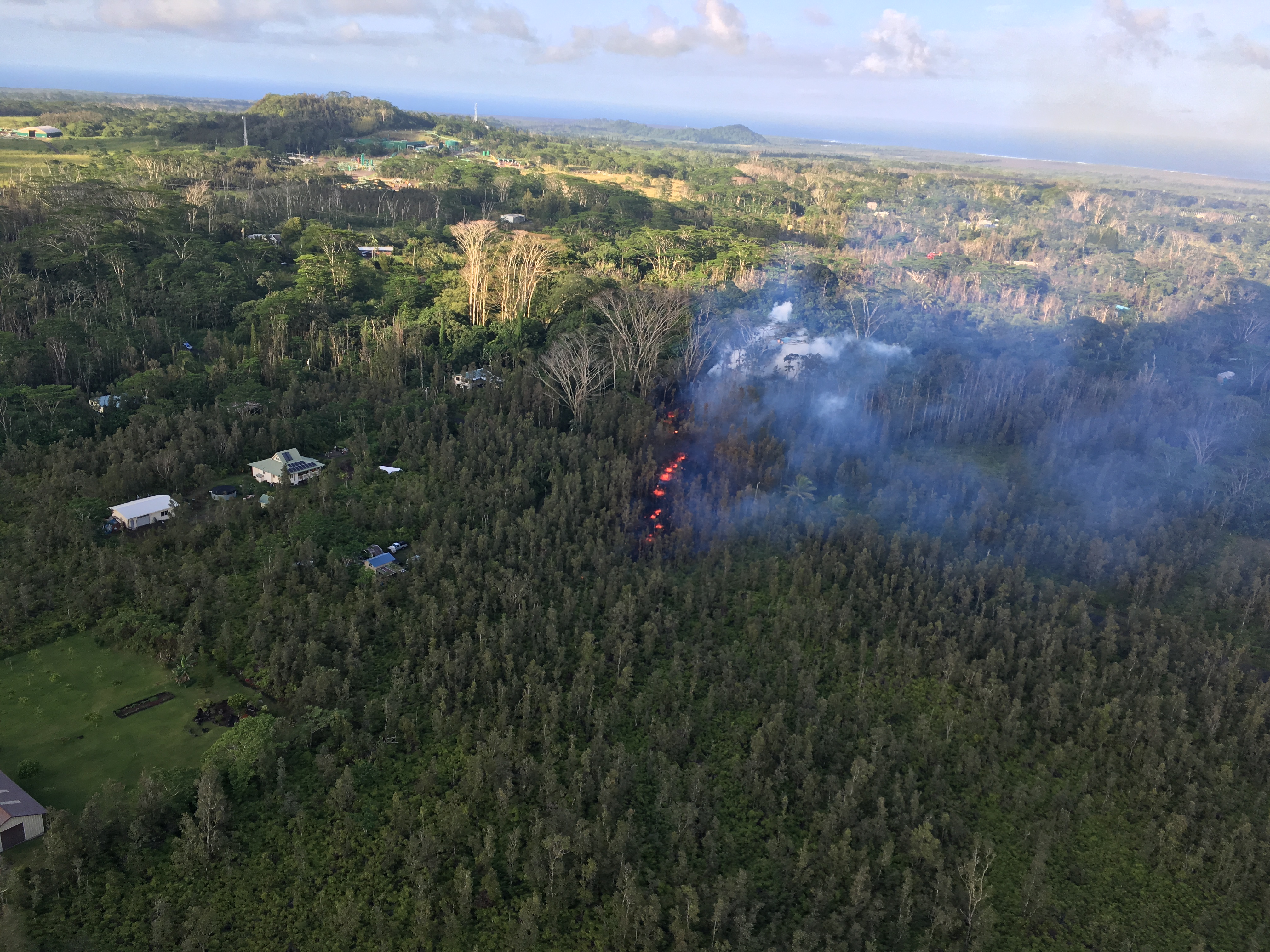
Fissure 5 opened shortly before 12:00 p.m. in Leilani Estates subdivision–Leilani Street runs left to right at the bottom of the photo; Kahukai Street is the cross street.
The sixth and most recent fissure is on the eastern edge of the subdivision. Not all fissure vents remain active and no far-traveled lava flows have formed.
HVO geologists will be in the area overnight to track additional activity that may occur, and other scientists are closely tracking the volcano’s overall activity using various monitoring data streams.
Seismicity and deformation are consistent with continued accumulation of magma within the rift zone. Additional outbreaks of lava are expected.
Source : HVO
Photo : U.S. Geological Survey
Piton de la Fournaise , La Réunion :
Activity Bulletin from Friday, May 4, 2018 at 3:00 pm (local time).
The eruption started on April 27, 2018 at 23:50 local time continues. The intensity of the volcanic tremor (indicator of surface eruptive intensity) is still relatively stable (Figure 1).
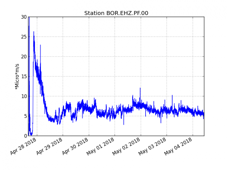
Figure 1: Evolution of the RSAM (Indicator of Volcanic Tremor and Eruption Intensity) between 20:00 (16:00 UTC) April 27 and 15:00 (11:00 UTC) May 4 at the BOR Seismic Station (at the top) . (© IPGP / OVPF)
The field reconnaissance carried out yesterday and today shows an activity mainly focused on the central vent with a cone now completely closed from which lava projections escape (Figure 2). The lava tunnel activity is now well-developed and frequent inroads into the roof of the tunnels let escape many arms of flows.
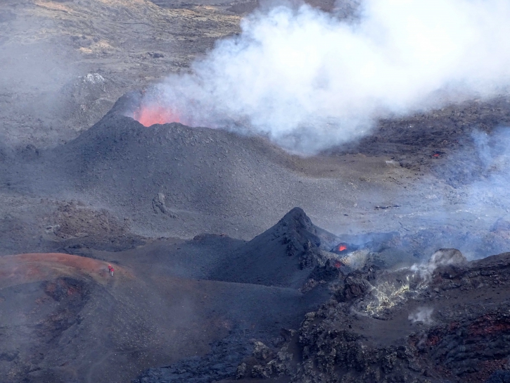
Figure 2: Shooting of the eruptive site on May 3rd (12h30 local time). (© IPGP / OVPF)
-The surface flows estimated from the satellite data, via the platform HOTVOLC (OPGC – Clermont Ferrand) and MIROVA (University of Turin), recorded today were between 1 and 3.5 m3 / s. It should be noted that these measures are only partial as a result of the bad weather conditions on the Fournaise massif during the last 24 hours.
– A very slight deflation (deflation) of the volcano is always recorded on the OVPF deformation sensors. This means that the volume of magma coming out of the reservoir to feed the eruption is greater than the volume of magma that replenishes it.
-No volcano-tectonic earthquake has been recorded in the last 24 hours under the Piton de la Fournaise building.
Alert level: Alert 2-2 – Eruption in the Enclos.
Source : OVPF.
Sheveluch , Kamchatka :
56.64 N, 161.32 E;
Elevation 10768 ft (3283 m), the dome elevation ~8200 ft (2500 m)
Aviation Colour Code is ORANGE
A moderate gas-steam activity of the volcano continues. Ash explosions up to 32,800-49,200 ft (10-15 km) a.s.l. could occur at any time. Ongoing activity could affect international and low-flying aircraft.
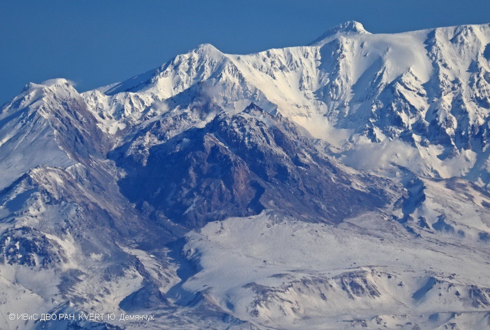
The lava dome of Molodoy Sheveluch on 25 March, 2018.
A moderate gas-steam activity of the volcano continues. Satellite data by KVERT showed a weak thermal anomaly over the volcano on 28 and 30 April and 02 May, the volcano was obscured by clouds in the other days of week.
Source : Kvert
Photo : Yu. Demyanchuk., IVS FEB RAS, KVERT, 25/3/2018 .
Pacaya , Guatemala :
Type of activity: Strombolian
Morphology: Composite Stratovolcano
Location: 14 ° 22’50˝Latitude N; 90 ° 36’00˝Longitude W.
Height: 2,552msnm.
Weather conditions: Clears
Wind: Southeast
Precipitation: 0.0 mm
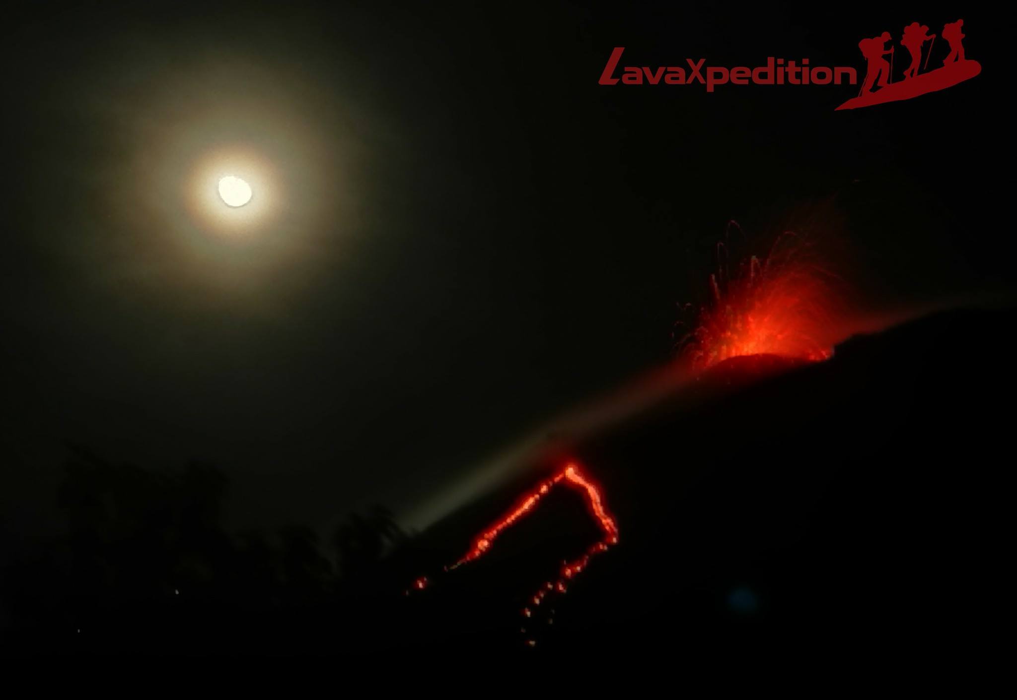
Activity:
The new Strombolian eruptive phase of the Pacaya volcano continues to generate constant explosions in the Mackenney crater. Because of this activity, the slag cone is built and destroyed. In the western part of the crater, a lava flow of 500 meters in length moves, reaching the base of the cone and forming a slow-moving small lava promontory, with avalanche constants observed from the middle and the before the flow.
Source : Insivumeh.
Photo : LavaXpedition