April 28 , 2018.
Piton de la Fournaise , La Réunion :
Activity Bulletin from Friday, April 27, 2018 at 8:30 pm (local time).
Following the resumption of seismic activity in line with the summit area of Piton de la Fournaise on April 21, 2018, and after a progressive increase in seismicity since 5:45 pm (local time) on April 27, a seismic crisis is recorded on the instruments of the Volcanological Observatory of Piton de la Fournaise since 20:15 local time on April 27, 2018.
This seismic crisis is accompanied by rapid deformation, This indicates that the magma is leaving the magma reservoir and is spreading to the surface.
An eruption is likely in the near future in the next minutes or hours.
Activity Bulletin from Saturday, April 28, 2018 at 00:30 (local time).
Following the seismic crisis started on April 27th at 8:15 pm, the volcanic tremor, synonymous with the arrival of magma near the surface, has been recorded since around 11:50 pm local time.
The analysis of the data and the observations from our cameras show that the eruptive fissure (s) opened on the south flank of the volcano, in the area of the crater Rivals (first visual return at 00:15 from the OVPF webcams ).
PRESS RELEASE:
ALERT 2-2
ERUPTION IN PROGRESS IN THE ENCLOS .
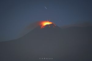
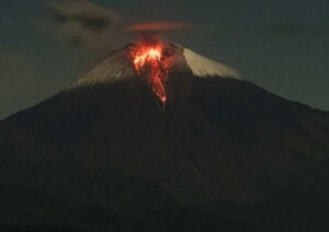
Following the seismic crisis started at 20:15 local time on Friday, April 27, 2018, the Piton de la Fournaise erupted at 23:50.
According to the information provided by the Volcanological Observatory of Piton de la Fournaise, the eruptive fissure (s) opened on the southern flank of the volcano, in the crater area Rivals.
As a result, the prefect of Reunion has decided to trigger alert 2-2 of the ORSEC * Volcano « eruption in progress », starting this Saturday, April 28, 2018 at 00:30.
Public access to the Fouqué enclosure, from the Pas de Bellecombe trail or from any other trail, as well as from aircraft in the volcano area, is prohibited until further notice.
As a reminder, the trail of the Nose Coupe Sainte-Rose is prohibited to pedestrian traffic from the Piton Sharing because of a real and imminent danger of collapse.
More complete recognition will take place later. Any significant change will be the subject of a new communication.
Source : OVPF
Photo : Rudy Laurent ( tokapatrando-reunion.com)
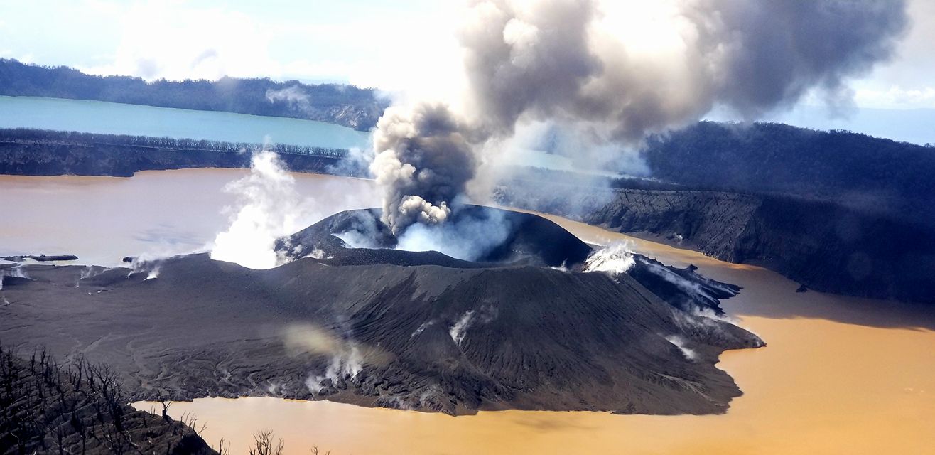
Ambae , Vanuatu :
Press release by VMGD, DoWR, MoHealth and GNS Science issued on 25th April 2018 about the Summary of the activity at Ambae Volcano: eruption and impacts:
For immediate release: Port Vila, Vanuatu, 24 April 2018
Ambae Volcano: Situation overview
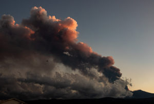
Ambae volcano is a large and geologically active volcano. It has a history of volcanic activity, with records dating back to 1530. In November 2005, the volcano experienced a significant new eruption and since this time has been in a variable state of volcanic unrest (ongoing volcanic activity). In early 2017, this volcanic unrest escalated and the volcano erupted in September 2017. This eruption has occurred over three time periods (phases): Phase 1 – September to late November 2017; Phase 2 – late December 2017 to early February 2018; and Phase 3 – February to April 2018 (ongoing).
Since September 2017 to present, this eruption has produced volcanic ash and acid rain. However, ash production and acid rain has been greater in Phase 3 (February 2018 – present). In Phase 3 there has been thick and widespread volcanic ashfalls across the island of Ambae, which have caused significant impacts on food supplies, water, shelter and the health of Ambae Island residents. This raises significant humanitarian issues.
Human health impacts:
Respiratory (breathing) impacts:
• Analysis of the volcanic ash from Ambae volcano eruption found that up to a third of all ash deposits consist of particles that are small enough to be breathed in (less than 0.1 mm).
• Breathing in such small particles as these (between 0.01 and 0.1 mm in size) can cause problems such as sore throats, coughs or throat infections, as the particles are breathed in and get caught in a person’s upper airways (nose and throat). These problems are usually short term and minor.
• Correct use of dust masks will minimize how much ash is breathed in. However, if a mask is incorrectly used it will be of little use. To correctly use a mask, use straps and any nose clip to fit mask tightly to face. The top strap should go high on head, and the bottom strap low. If you feel air escaping around the edges of the mask, adjust it until there are no gaps. A layer of cloth tied on top of the mask can help to hold it to the face. Note that masks will not fit very well to children or people with beards.
• Some people with underlying breathing conditions such as asthma may find their symptoms getting worse. Anyone who has concerns about their health, or their children’s health, should go to the clinic.
Drinking water:
• Volcanic gas, acid rain and ash can make drinking-water look cloudy, and taste bad (metallic, or sour like lemon juice). The metallic taste is due to chemical elements such as aluminum that are released into the water from the surface of the ash. These metallic elements are not a health risk. Cloudy and bad-tasting water can still be used for laundry and bathing, and even for cooking, except for cooking rice as it absorbs water.
• Ash can also add fluoride to the water. If people drink this water for a short time, even for heavy ashfalls (>20 cm) it is unlikely to be a health risk for adults and older children.
• For babies and younger children, heavy ashfalls may add enough fluoride to water to cause some stomach problems but is unlikely to cause more serious health problems.
• It is recommended that everyone, but in particular children, avoid drinking water with high fluoride over a long time as it can cause problems for the teeth and bones.

Environmental impacts:
Ashfalls have caused leaves to fall off trees, broken plant stalks and tree branches, buried crops, and collapsed trees. The acid rain from the volcanic steam and gas plume has burnt and damaged plants. Ash coatings released into the water can have a similar impact. The sustainability of local crops for food supply and animal food is greatly reduced.
The ashfalls are now thick enough to damage and in some cases destroy traditional buildings. No lives have been lost due to building collapse. However about half of the traditional buildings that experienced more than about 50 mm of volcanic ash are unusable. More modern buildings appear to be less damaged.
From observations around the world, following volcanic ashfall events remobilisation of the volcanic ash can occur, months to years later, even after the eruption has stopped. Remobilisation can be due to wind or water (rainfall).
If the deposit dries out, fine ash can be lifted into the air by wind, so it can cause ongoing breathing problems. Wind remobilisation effectively re-exposes assets, animals and people to the ash. This mean the people will experience the physical impacts again.
If the ash has been washed by rain, there is less of a risk of chemical contamination of water supplies again. Some water supplies will be re-impacted and experience turbidity (milky or cloudy water).
Rainfall induced remobilisation usually results in streams and rivers carrying significantly larger sediment loads which produce much larger than normal flood impacts. Some floods are now occurring in rain. These can occur for several years after an eruption of the current size stops.
Volcanic gas emissions are likely to continue. Gas in village is unlikely to be a health risk for most people but may be a problem for people with breathing conditions such as asthma. If these people are feeling unwell because of gas (headache, difficulty breathing, stinging eyes) take them to clinic.

Further information about Ambae Volcano:
Ambae volcano is a large and geologically active volcano. A large-scale eruption about 400 years ago built a volcanic cone in the summit crater of the volcano. Today the crater is filled by Lake Voui; the recent volcanic activity comes from vents in Lake Voui. Historic activity is poorly understood, but there are records of activity in 1530, 1670, 1870, 1915 and 1966. All recorded activity has been from the summit crater except for the 1670 activity, which included a flank eruption producing lava flows in the Nduindui area.
The 2017-2018 eruption is part of a longer sequence of volcanic activity that started with volcanic unrest in 1991, leading to an eruption in March 1995. From 1995 to 2005 volcanic unrest was often noted at Lake Voui. A significant new eruption started in November 2005. This eruption built a new volcanic cone (island) in Lake Voui and activity continued until early 2006.
Ambae volcano stayed in a variable state of volcanic unrest through to late 2016. Most of the island built in 2005 was eroded away during this time. Another volcanic eruption occurred around July-August 2016. Volcanic unrest escalated in early 2017 and an eruption was under way by September, building a new volcanic cone (island) in Lake Voui.
The current eruption is characterised by three phases; Sept to late Nov 2017, late Dec 2017 to early Feb 2018 and Feb to April 2018 (ongoing). The eruption has built and destroyed and rebuilt a volcanic cone in Lake Voui. The third phase has produced thick and widespread volcanic ashfalls across the island of Ambae.
Prepared 24 April 2018 by VMGD, DoWR, MoHealth and GNS Science.
Please note assessments are ongoing and the results of later analysis may change these observations.
Source : Vanuatu Meteorology and Geohazards Department.
Photos : Dikinson Tavi. David Sarginson .
Pacaya , Guatemala :
SPECIAL BULLETIN OF VULCANOLOGICAL BEPAC # 17-2018 Guatemala April 27, 2018, 10:00 am (local time)
INCREASE ACTIVITY
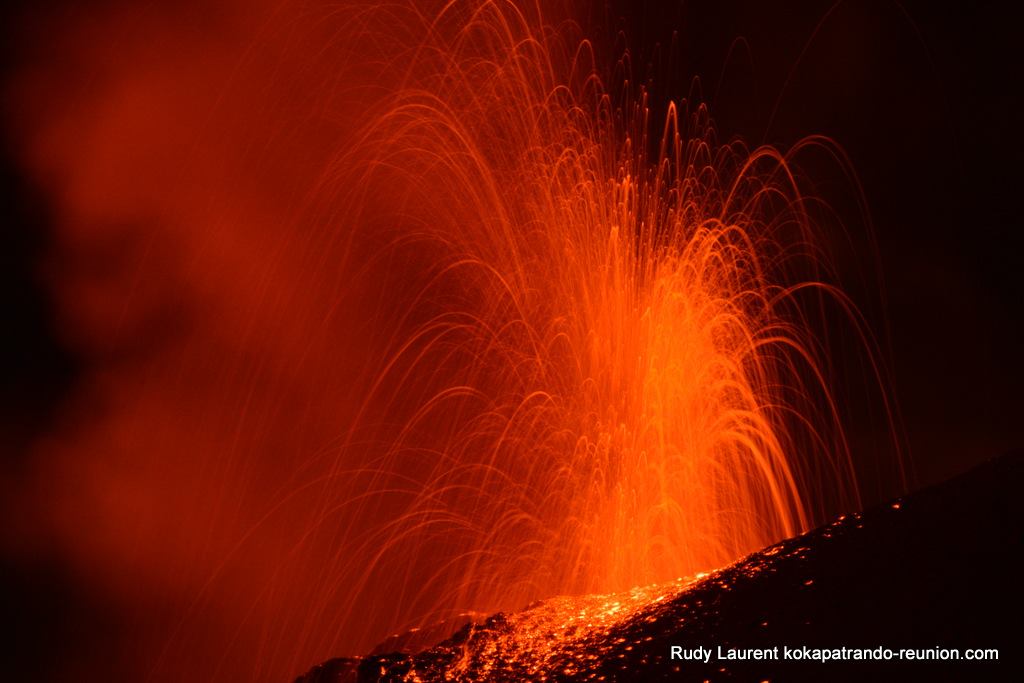
Type of activity: Strombolian
Morphology: Composite stratovolcan
Location: 14 ° 22’50˝ Latitude N; 90 ° 36’00˝ Longitude W.
Height: 2,552m.
During the last 6 hours, the PCG seismic station has recorded an increase in internal tremors. OVPAC reports weak, moderate and sometimes strong explosions, but with less consistency these strombolian explosions reach heights up to 150 meters above the crater and result in the formation of a slag cone. which is constantly collapsing.
Because of the intensity of the explosions, we observe moderate avalanches that move the blocks from the crater to the base of it, for the moment, there is no information on the movement of the ash.
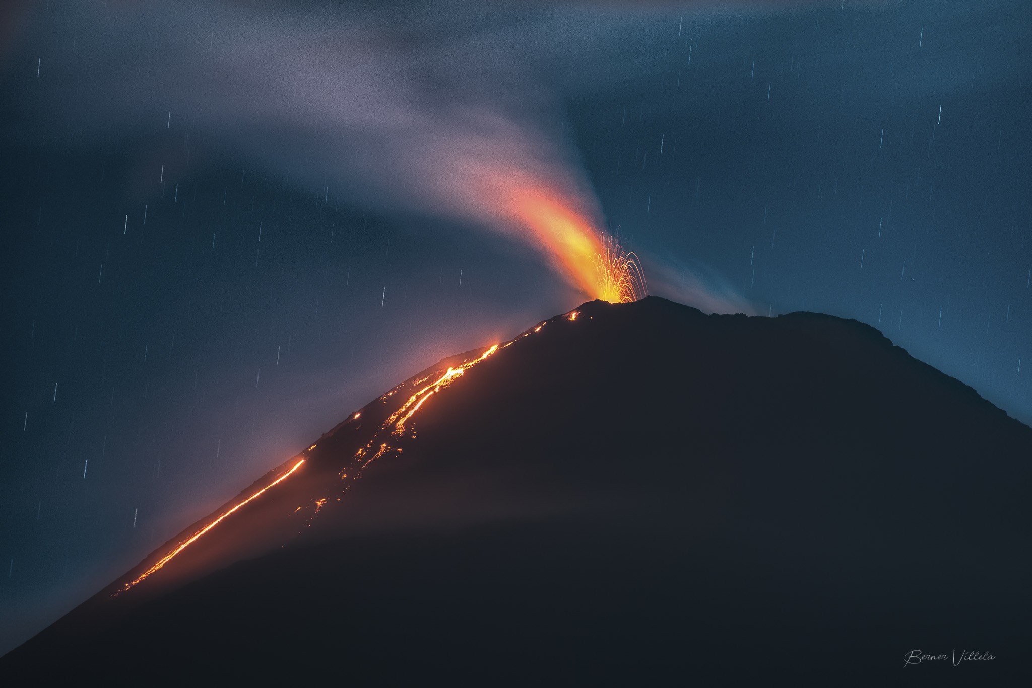
Strombolian activity is normal on a volcano such as Pacaya and although there is no report of lava flows, the possibility that they are generated in the following hours occurring in the crater or in the cracks cone is not excluded.
Because of this activity, it is recommended not to stay in areas near the cone because avalanches of larger blocks can occur and not allow crater ascent, as current activity can cause explosions and explosions. projections at higher altitudes.
Source : Insivumeh
Photo : B . Villela
Dukono , Indonesia :
VOLCANO OBSERVATORY NOTICE FOR AVIATION – VONA.
Issued: April 28 , 2018.
Volcano: Dukono (268010)
Current Aviation Colour Code: ORANGE
Previous Aviation Colour Code: orange
Source: Dukono Volcano Observatory
Notice Number: 2018DUK53
Volcano Location: N 01 deg 41 min 35 sec E 127 deg 53 min 38 sec
Area: North Maluku, Indonesia
Summit Elevation: 3933 FT (1229 M)
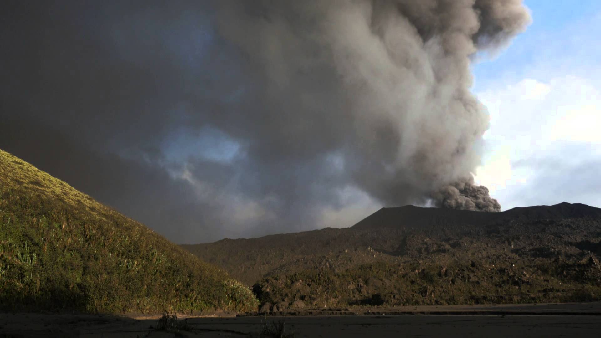
Volcanic Activity Summary:
Eruption with volcanic ash cloud at 23h56 UTC (08h56 local).
Volcanic Cloud Height:
Best estimate of ash-cloud top is around 4893 FT (1529 M) above sea level, may be higher than what can be observed clearly. Source of height data: ground observer.
Other Volcanic Cloud Information:
Ash cloud moving to East.
Remarks:
Eruption and ash emission is continuing.
Source : Magma Indonésie.
Photo : Photovolcanica
San Miguel ( Chaparrastique) , El Salvador :
Special Report No. 4
The seismic vibration of the Chaparrastic volcano continues at a low level. Date and time of broadcasting: 27 April 2018, 14:30:00
During the last seven days, the seismic vibration of the volcano remained fluctuating between 37 and 106 RSAM units / hour on average, when the normal is 150. That is, low, which indicates the decompression of the system (Figure 1)

Figure 1. Seismic vibrations of the volcano in 58 average RSAM units from April 21 to April 27, 2018.
It should be noted that during the period from 19 to 26 April, 12 earthquakes of very small magnitude and depth were located on the area of the northern flank and crater (Figure 2), with amplitudes between M0.8 and M1. 8. Not felt by the population.

Figure 2. Most earthquakes are associated with fluid movements in the system, low frequency events.
The volcano was influenced by weather clouds, so no gas exhalation was observed (Figure 3). There is also no report of changes in volcano activity by the network of local observers. The active state of the volcano and the type of seismicity indicate that it will continue to show sudden changes in its behavior
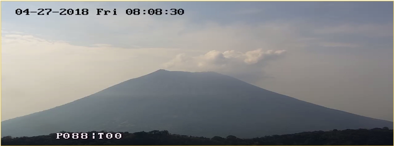
Figure 3. View of the volcano with the web camera located on the Pacayal volcano at 08:08.
The behavior described above, indicates the presence of magmatic fluids moving in the internal ducts of the volcano, so that it does not exclude the changes of its activity in the weeks or months to come.
The Ministry of Environment and Natural Resources (MARN) continues the systematic monitoring of the volcano and maintains close communication with the Directorate General of Civil Protection and the Network of Local Observers.
In addition, it calls on the population to stay away from the top of the volcano, as abrupt changes in behavior often occur and can cause physical damage.
Source : Marn.