April 15 , 218.
Ambae , Vanuatu :
Vanuatu island to evacuate again as volcano erupts .
13 APRIL 2018. Villagers on the Vanuatu island of Ambae were facing their second evacuation in seven months Friday after a volcano rumbled back to life and rained ash on their homes.
Authorities in the Pacific nation have declared a state of emergency on the northern island, where 11,000 people were forced to leave last September.
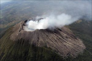
Many have only just returned home but the Vanuatu Meteorology and Geo-Hazards Department said the Manaro Voui volcano was undergoing a level three eruption, the mid-point in a five-level scale.

Map of Vanuatu, locating the Manaro Voui volcano.
National disaster ministry director general Jesse Benjamin said any evacuation would be more orderly than the one carried out in September, when a flotilla of small vessels were pressed into service to rush people off the island.
« Last year’s evacuation was conducted in haste, amidst fears of a major eruption, » he told the Daily Post newspaper.
« There is some dissatisfaction about the way we moved people at the time. This time we will be evacuating people from the severely affected communities first, before the less affected. « The government is worried about the safety of the people. »
Vanuatu, which has a population of about 280,000 spread over 65 inhabited islands, is regarded as one of the most disaster-prone countries in the world.
Ash Fall Destruction on North Ambae – Vanuatu Daily Post
14 APRIL 2018. William Bice Qorig, Rector, has shared photos of the destruction of Ash Fall from Manaro Voui Volcano on North Ambae. “Excessive ash fell during the night on the 8th and 9th of April, 2018,” the North Ambae Anglican Church Leader informed Daily Post.
“Ash 20 – 30cm thick has destroyed houses and churches in the Lombaha District on north Ambae. “The District continues to experience ash, acid rain, sulphur gas and stones, falling from the volcano.
“All crops and trees are destroyed by the ash fall. There is no food. All water storage is destroyed by the sand and acid rain. There is no water. “Some churches and homes are destroyed in the Parish because of the excessive nonstop ash fall.”
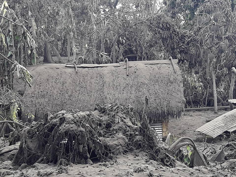
Father Qorig said the road is destroyed, due to trees falling on the road due to the ash fall and heavy rains. One tree fell across the road near the Catholic Church, blocking the way for all vehicles passing through.
“If supplies are available soon, they will need to travel by boat and the remainder of the journey will be on foot and man handled to clear the obstacle of the tree on the road,” said Father Qorig.
“Families with children are at risk. The elderly and the people with disabilities are at risk. “They are now experiencing flu like symptoms and sore throats. Teenagers are writing to me saying that they are frightened.”
Source : Phys.org , Vanuatu Daily Post .
Photos : Dickinson Tevi , Ghevin Banga 09.04.2018
Sinabung , Indonesia :
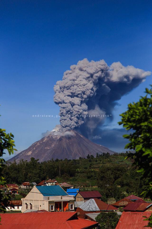
VOLCANO OBSERVATORY NOTICE FOR AVIATION – VONA.
Issued: April 15 , 2018
Volcano: Sinabung (261080)
Current Aviation Colour Code: ORANGE
Previous Aviation Colour Code: orange
Source: Sinabung Volcano Observatory
Notice Number: 2018SIN96
Volcano Location: N 03 deg 10 min 12 sec E 98 deg 23 min 31 sec
Area: North Sumatra, Indonesia
Summit Elevation: 7872 FT (2460 M)
Volcanic Activity Summary:
Eruption with ash clouds started at 01:38 UTC ( 08:38 local time). The eruption still continuing
Volcanic Cloud Height:
Best estimate of ash-cloud top is around 11072 FT (3460 M) above sea level, may be higher than what can be observed clearly. Source of height data: ground observer.
Other Volcanic Cloud Information:
Ash cloud is moving to west-northwest
Remarks:
Seismic activity is characterized by the Deep Volcanic Earthquake, Low Frequency Earthquake, and Hybrid Earthquake
Source : Magma Indonésie.
Photo : Endro Lewa.
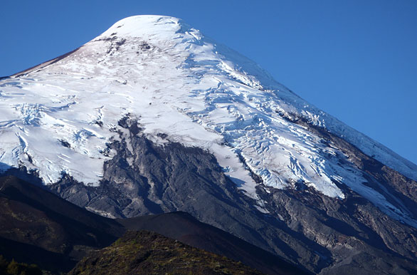
Osorno , Chile :
Special Report on Volcanic Activity (REAV), Los Lagos Region, Osorno Volcano
April 14, 2018,14: 30 Local (continental Chile)
The National Service of Geology and Mines of Chile (Sernageomin) discloses the following information, obtained through the monitoring equipment of the National Network of Volcanic Surveillance (RNVV), processed and analyzed at the Volcanological Observatory of the Southern Andes. (OVDAS):
On Saturday 14 April at 13:35 local time (16:35 GMT), monitoring stations near the Osorno volcano recorded an earthquake associated with rock fracturing (Volcano-Tectonic type). The earthquake was located 3.1 km northwest (NW) of the volcano.
The characteristics of the earthquake after its analysis are as follows:
TIME OF ORIGIN: 13:35 local time (16:35 GMT)
LATITUDE: 41.083 ° S
LONGITUDE: 72.509 ° C
DEPTH: 3.88 km
LOCAL MAGNITUDE: 3.0 (ML)
OBSERVATIONS:
1 replica was recorded, of smaller magnitude. There is no information on the perception of the main event.
The volcanic technical alert remains at:
Warning level GREEN
Sernageomin monitors online and informs on a timely basis of any changes in volcanic activity in the country.
Source : Sernageomin
Photo : Cristina Sabaliauskas .
Piton de la Fournaise , La Réunion :
21 ° 14’38 « S
55 ° 42’29 « E
Altitude: 2632m
Alert level: Vigilance.
Daily bulletin:

Seismology:
– Number of landslides of 14-04-2018: 21
Areas affected by landslides:
Summit cone
Enclos
– Number of volcano-tectonic earthquakes (VT) from 14-04-2018: 0
– Volcanano-tectonic earthquake of greater magnitude of 14-04-2018:
Duration: 0 s
Duration Magnitude: 0.00
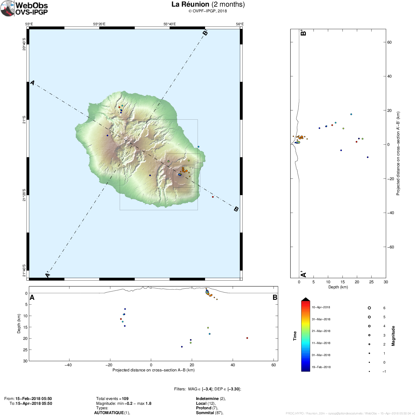
Location of earthquakes over 2 months. Only localizable earthquakes have been represented on the map.
The observatory records seismic events not shown on this map because they are not localizable due to their low magnitude.
To see the number of earthquakes detected by the Observatory’s networks, you can refer to its last Activity Bulletin.
Deformities:
– The GPS of the zone summit record an inflation, witnessing the putting in pressure of a superficial source.
– GPS in the far field record inflation, witnessing the setting in pressure of a deep source.
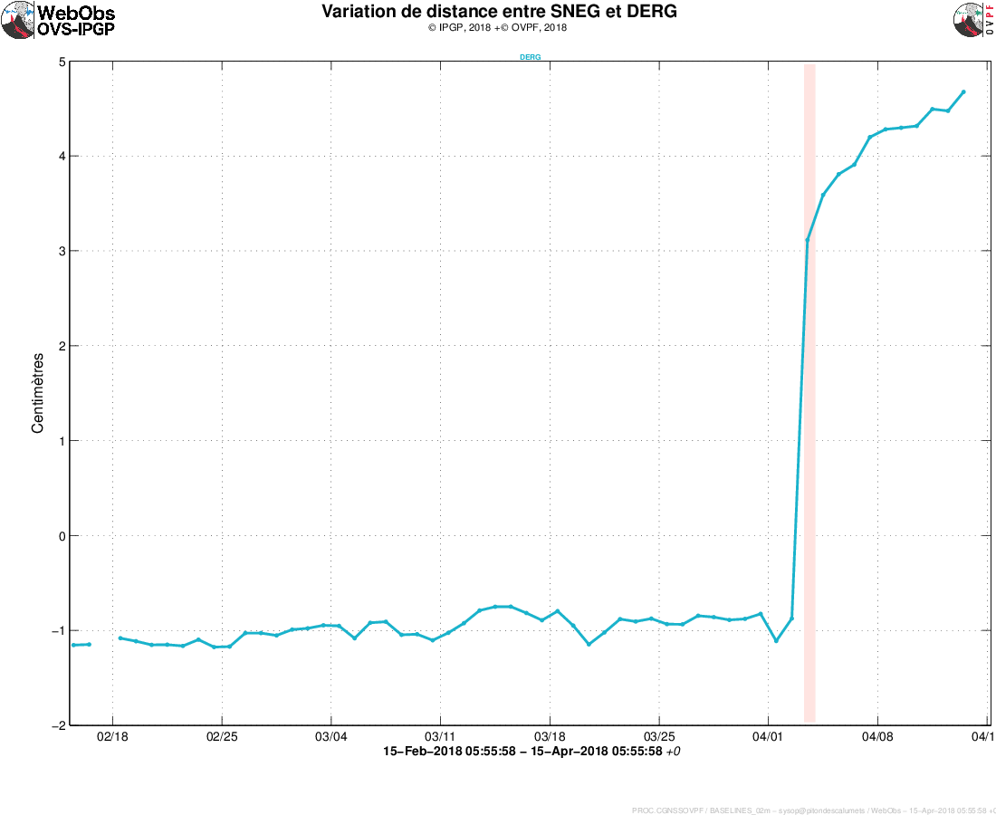
Illustration of the summit deformation over 2 months. Here is shown a baseline (variation of distance between two GPS receivers) crossing the crater Dolomieu (see location). A rise is synonymous with elongation and therefore swelling of the volcano; conversely, a decrease is synonymous with contraction and therefore deflation of the volcano. Any periods colored in light pink correspond to eruptions.
Geochemistry:
Concentrations of H2S and SO2 at the top: below or near the detection limit.
Source : OVPF
Photo : Guichard