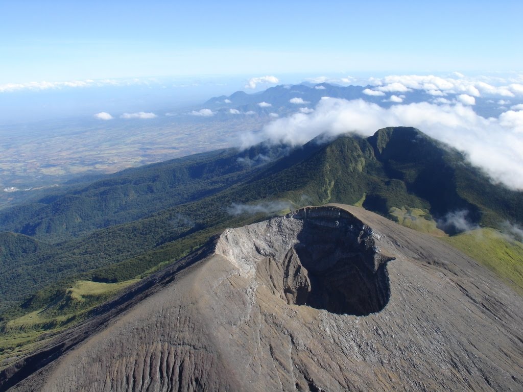
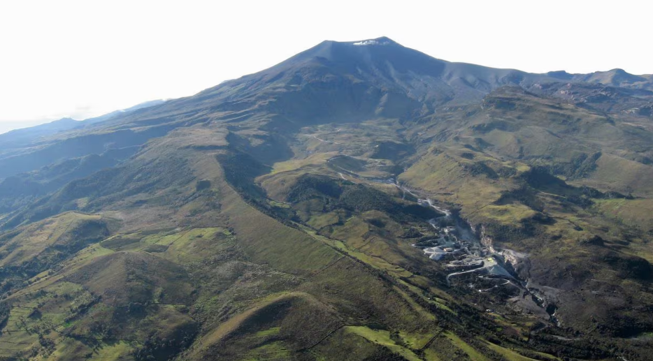
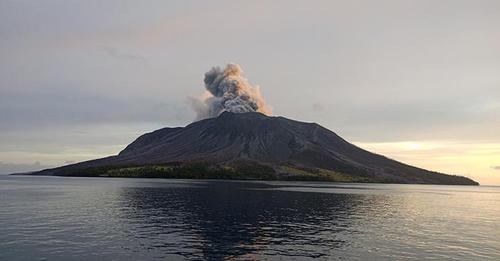
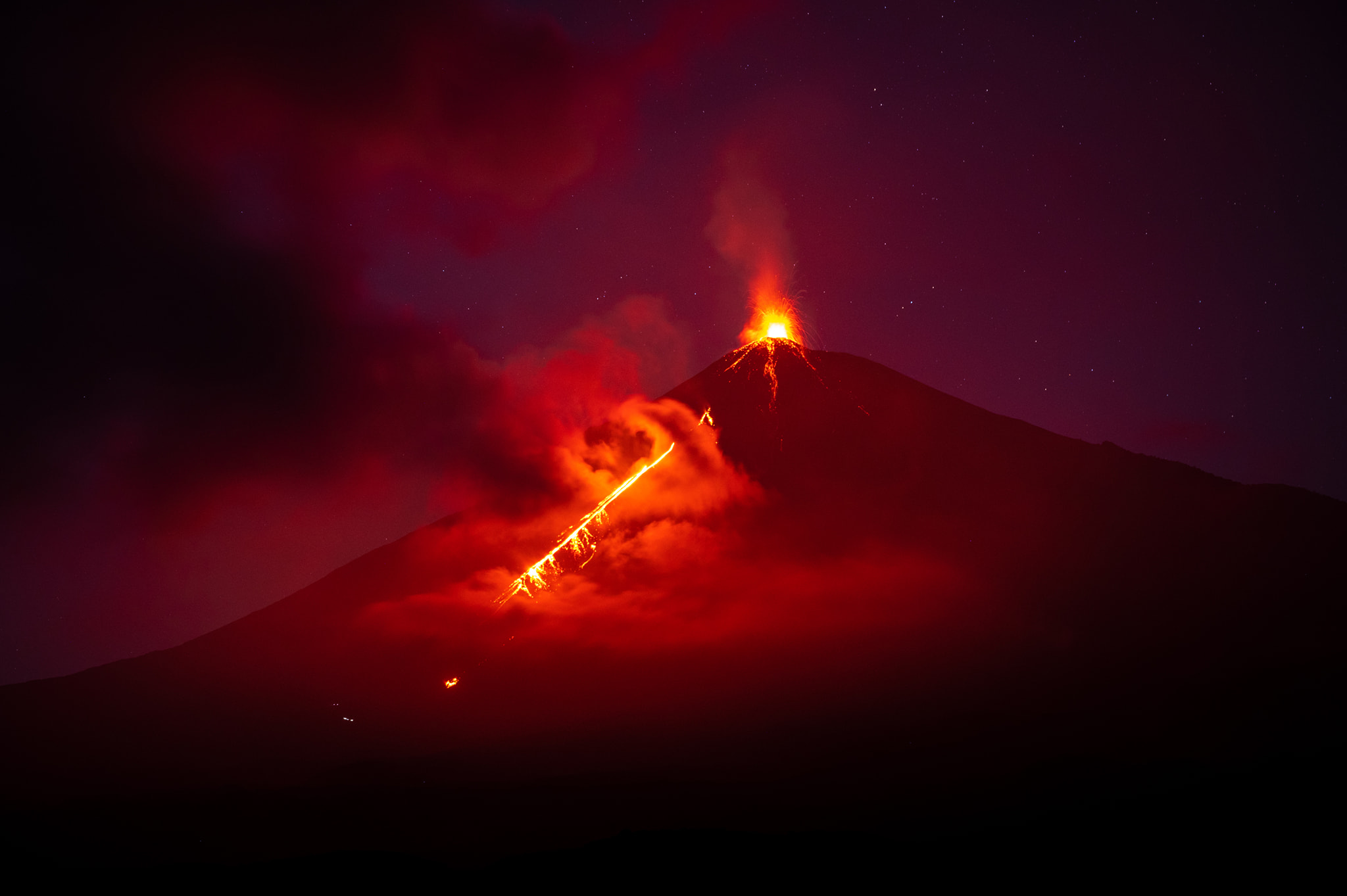
November 10, 2022. EN. Chile : Nevados de Chillan , Ecuador : Cotopaxi , Iceland : Grímsvötn , Japan : Suwanosejima , Alaska : Great Sitkin .

November 10 , 2022.


Chile , Nevados de Chillan :

Seismology
The seismological activity of the period was characterized by the recording of:
57 volcano-tectonic (VT) earthquakes associated with brittle rupture processes; the most energetic earthquake had a local magnitude (ML) equal to 2.0, the location of which was estimated at a depth of 4 km and an epicentral distance of 4.5 km to the East-South-East by relative to the active crater.
Long period (LP), explosion (EX) and tremor (TR) seismicity continued to be recorded, associated with fluid dynamics within the volcanic system. 312 LP-type earthquakes were classified, of which 7 were related to explosions at surface level, due to the presence of acoustic waves and/or gaseous emissions, specifying that the recording of the two characteristics mentioned is difficult due to adverse weather conditions, which may lead to a decrease from the ideal count for this type of event. The size of the largest LP earthquake estimated from the Reduced Displacement (DR) parameter reached a value equal to 961 cm2 on October 17, whose seismic energy corresponds to one of the largest recorded in the entire eruptive process. current . In addition, this event marks the end of the explosive process observed in recent weeks, giving way to a period of very low energy for a fluid seismicity comparable to the levels observed in the first eruptive phases, but with an upward trend, which initially suggests an internal system in recovery.
Regarding TR type seismicity, only 11 episodes were recorded, the most important of which reached a DR of 11 cm2. After the largest explosion, no such event was observed.

Satellite thermal anomalies
1 thermal alert was recorded in the area associated with the volcanic complex during the period, with a maximum Volcanic Radiative Power (VRP) of 3 MW on October 17, a value considered low according to data processed by the Middle Infrared of Observation of Volcanic Activity (MIROVA, http://www.mirovaweb.it/). A decrease in thermal alerts is observed, both in their recurrence and in their power during the reported period.
At the same time, according to the analytical processing of satellite images (Sentinel 2-L2A in combination of false color bands), no luminance anomaly was reported during the period evaluated.

Satellite geomorphological analysis
From the geomorphological observations carried out on the Planet Scope and Sentinel 2 L2A satellite images, the effects of the intense explosive activity that occurred in the first days of this period were observed, with the identification of pyroclastic deposits falling towards North-East, North-West directions. and South-East, and pyroclastic flows on the North, North-North-East, North-East, East, North-West and West flanks. However, no relevant morphological variation is observed after these events.

The Nevados de Chillán volcanic complex has entered a very low energy phase with levels similar to those observed in the early stages of this eruption in 2016, or during the minimum levels of the magmatic pause after L4 lava in 2019. This with the absence of TR, indicates a higher level of sealing of the surface system and/or a magmatic depletion sufficient to terminate the immediately preceding explosive process. Despite the above, the volcanic system continues with a lower seismicity, with a subtle upward trend, which could suggest, as has happened on other occasions, reactivations of the magmatic process. Other monitoring parameters such as deformation, SO2 emissions and thermal anomalies remain low and stable. As for the surface activity, it was mainly concentrated on October 16 and 17, with the emission of vigorous eruptive columns, where pyroclastic flows were generated in various directions with significant ranges towards the North-East flank. A possible assignment zone with a radius of 2 km around the active crater is maintained.

YELLOW TECHNICAL ALERT: Changes in the behavior of volcanic activity.

Source : Sernageomin.

Read the article : https://rnvv.sernageomin.cl/rnvv/TI_Santiago_prod/reportes_LB/2022/RAV_20221109_%C3%91uble_v20.pdf

Photos : Explora turismo , Sernageomin.


Ecuador , Cotopaxi :

DAILY REPORT OF THE STATE OF COTOPAXI VOLCANO, Wednesday November 09, 2022.
Information Geophysical Institute – EPN.

Surface Activity Level: Low, Surface Trend: Ascending
Internal activity level: Low, Internal trend: No change.

Seismicity: From November 08, 2022, 11:00 a.m. to November 09, 2022, 11:00 a.m.:

There was no interruption in the transmission of data from the BREF reference station for seismic statistics.

Long Periods (LP): 75

Rains / Lahars:
Rains were recorded in the volcano area yesterday.

Emission / ash column:
In the morning hours, a continuous emission of gas and water vapor could be observed up to about 200 meters above the level of the crater, oriented towards the West.

Observation:
Currently the area of the volcano is cloudy.

Gas:
The gas measurements observed in the DOAS network installed on the flanks of the volcano reflect an increase in the degassing trend from November 5.

Niveau d’alerte: Jaune .

Source  et photos : IGEPN.


Iceland , Grímsvötn :

On 9 November Icelandic Meteorological Office (IMO) lowered the Aviation Color Code for Grímsvötn to Green (the lowest level on a four-color scale) noting no short-term increases in activity, though long-term trends remained above background levels. Seismicity continued to be characterized as unusual, with an increasing number of earthquakes that were also intensifying over the past months. The levels of deformation had already exceeded the level measured before the last eruption in 2011.

Grímsvötn, Iceland’s most frequently active volcano in recent history, lies largely beneath the vast Vatnajökull icecap. The caldera lake is covered by a 200-m-thick ice shelf, and only the southern rim of the 6 x 8 km caldera is exposed. The geothermal area in the caldera causes frequent jökulhlaups (glacier outburst floods) when melting raises the water level high enough to lift its ice dam. Long NE-SW-trending fissure systems extend from the central volcano. The most prominent of these is the noted Laki (Skaftar) fissure, which extends to the SW and produced the world’s largest known historical lava flow in 1783. The 15 km3 basaltic Laki lavas were erupted over a 7-month period from a 27-km-long fissure system. Extensive crop damage and livestock losses caused a severe famine that resulted in the loss of one-fifth of the population of Iceland.

Source: Icelandic Meteorological Office (IMO) , GVP

Photo : Laki , Chmee2/Valtameri / Wikipedia.


Japan , Suwanosejima :

JMA reported that the eruption at Suwanosejima’s Ontake Crater continued during 31 October-7 November and crater incandescence was visible nightly. An explosion at 0137 on 4 November produced an eruption plume that rose 2.4 km above the crater rim and ejected large blocks 200 m from the vent. Ashfall was reported in Toshima village (3.5 km SSW). The Alert Level remained at 2 and the public was warned to stay 1 km away from the crater.

The 8-km-long island of Suwanosejima in the northern Ryukyu Islands consists of an andesitic stratovolcano with two historically active summit craters. The summit is truncated by a large breached crater extending to the sea on the east flank that was formed by edifice collapse. One of Japan’s most frequently active volcanoes, it was in a state of intermittent Strombolian activity from Otake, the NE summit crater, between 1949 and 1996, after which periods of inactivity lengthened. The largest recorded eruption took place in 1813-14, when thick scoria deposits blanketed residential areas, and the SW crater produced two lava flows that reached the western coast. At the end of the eruption the summit of Otake collapsed, forming a large debris avalanche and creating the open Sakuchi caldera, which extends to the eastern coast. The island remained uninhabited for about 70 years after the 1813-1814 eruption. Lava flows reached the eastern coast of the island in 1884. Only about 50 people live on the island.

Source: Japan Meteorological Agency (JMA), GVP

Photo : N. Geshi. Geological Survey of Japan, H.Seo


Alaska , Great Sitkin :

AVO reported that slow lava effusion continued at Great Sitkin during 2-8 November and seismicity was low. Satellite images were often cloudy, though elevated surface temperatures were identified almost daily. The flow field continued to grow, with lobes of lava extending more than 600 m E and around 430 m S. The Volcano Alert Level remained at Watch (the second highest level on a four-level scale) and the Aviation Color Code remained at Orange (the second highest level on a four-color scale).

52°4’35 » N 176°6’39 » W,
Summit Elevation 5709 ft (1740 m)
Current Volcano Alert Level: WATCH
Current Aviation Color Code: ORANGE

Lava continues to erupt in the summit crater of Great Sitkin Volcano. Seismicity was low over the past day. Elevated surface temperatures were observed in satellite imagery twice during the last 24 hours. Web camera views were obscured by clouds.

Great Sitkin Volcano is monitored by local seismic and infrasound sensors, satellite data, web cameras, and regional infrasound and lightning networks.

Source : GVP , AVO.

Photo : First Officer Joseph Leman, submitted by Captain Dave Clum.

10 Novembre 2022. FR. Chili : Nevados de Chillan , Equateur : Cotopaxi , Islande : Grímsvötn , Japon : Suwanosejima , Alaska : Great Sitkin .

10 Novembre 2022.


Chili , Nevados de Chillan :

Sismologie
L’activité sismologique de la période a été caractérisée par l’enregistrement de :
57 séismes volcano-tectoniques (VT) associés à des processus de rupture fragile ; le tremblement de terre le plus énergétique avait une magnitude locale (ML) égale à 2,0, dont la localisation a été estimée à une profondeur de 4 km et une distance épicentrale de 4,5 km à l’Est-Sud-Est par rapport au cratère actif.
La sismicité de type longue période (LP), d’explosion (EX) et de tremor (TR) a continué d’être enregistrée, associée à la dynamique des fluides au sein du système volcanique. 312 tremblements de terre de type LP ont été classés, dont 7 étaient liés à des explosions au niveau de la surface, en raison de la présence d’ondes acoustiques et/ou d’émissions gazeuses, précisant que l’enregistrement des deux caractéristiques mentionnées est difficile en raison de conditions météorologiques défavorables, ce qui ce qui peut conduire à une diminution par rapport au décompte idéal de ce type d’événement. La taille du plus grand séisme LP estimée à partir du paramètre Déplacement Réduit (DR) a atteint une valeur égale à 961 cm2 le 17 octobre, dont l’énergie sismique correspond à l’une des plus importantes enregistrées dans l’ensemble du processus éruptif actuel . De plus, cet événement marque la fin du processus explosif observé au cours des dernières semaines, laissant place à une période de très basse énergie pour une sismicité fluide comparable aux niveaux observés dans les premières phases éruptives, mais avec une tendance à la hausse, qui initialement suggère un système interne en récupération.
Concernant la sismicité de type TR, seuls 11 épisodes ont été recensés dont le plus important a atteint un DR de 11 cm2. Après la plus grande explosion, aucun événement de ce type n’a été observé.

Anomalies thermiques satellitaires
1 alerte thermique a été enregistrée dans la zone associée au complexe volcanique au cours de la période, avec une Puissance Radiative Volcanique (VRP) maximale de 3 MW le 17 octobre, une valeur considérée comme faible selon les données traitées par le Moyen Infrarouge d’Observation de l’Activité Volcanique (MIROVA, http://www.mirovaweb.it/). Une diminution des alertes thermiques est observée, tant dans leur récurrence que dans leur puissance durant la période reportée.
Parallèlement, selon le traitement analytique des images satellitaires (Sentinel 2-L2A en combinaison de bandes de fausses couleurs), aucune anomalie de luminance n’a été signalée durant la période évaluée.

Analyse géomorphologique satellitaire
A partir des observations géomorphologiques réalisées sur les images satellites Planet Scope et Sentinel 2 L2A, les effets de l’activité explosive intense qui s’est produite dans les premiers jours de cette période ont été observés, avec l’identification de dépôts pyroclastiques retombant vers les directions Nord-Est, Nord-Ouest. et Sud-Est, et des coulées pyroclastiques sur les flancs Nord, Nord-Nord-Est, Nord-Est, Est, Nord-Ouest et Ouest. Cependant, aucune variation morphologique pertinente n’est observée après ces événements.

Le complexe volcanique Nevados de Chillán est entré dans une phase de très basse énergie avec des niveaux similaires à ceux observés dans les premiers stades de cette éruption en 2016, ou pendant les niveaux minimaux de la pause magmatique après la lave L4 en 2019. Ceci avec l’ absence de TR, indique un niveau d’étanchéité plus élevé du système de surface et/ou un appauvrissement magmatique suffisant pour mettre fin au processus explosif immédiatement précédent. Malgré ce qui précède, le système volcanique continue avec une sismicité plus faible, avec une tendance à la hausse subtile, ce qui pourrait suggérer, comme cela s’est produit à d’autres occasions, des réactivations du processus magmatique. D’autres paramètres de surveillance tels que la déformation, les émissions de SO2 et les anomalies thermiques restent faibles et stables. Quant à l’activité de surface, elle s’est principalement concentrée les 16 et 17 octobre, avec l’émission de colonnes éruptives vigoureuses, où des coulées pyroclastiques ont été générées dans diverses directions avec des portées importantes vers le flanc Nord-Est. Une zone d’affectation possible d’un rayon de 2 km autour du cratère actif est maintenue.

ALERTE TECHNIQUE JAUNE : Modifications du comportement de l’activité volcanique.

Source : Sernageomin.

Lire l’articlehttps://rnvv.sernageomin.cl/rnvv/TI_Santiago_prod/reportes_LB/2022/RAV_20221109_%C3%91uble_v20.pdf

Photos : Explora turismo , Sernageomin.


Equateur : Cotopaxi :

RAPPORT QUOTIDIEN DE L’ETAT DU VOLCAN COTOPAXI , Mercredi 09 Novembre 2022.
Information Geophysical Institute – EPN.

Niveau d’activité Superficiel: Bas , Tendance de surface : Ascendante
Niveau d’activité interne: Bas , Tendance interne : Pas de changement .

Sismicité : Du 08 Novembre 2022 , 11:00h au 09 Novembre 2022 , 11:00h : 

Il n’y a eu aucune interruption dans la transmission des données de la station de référence BREF pour les statistiques sismiques.

Longues périodes (LP) : 75


Pluies / Lahars :
Des pluies ont été enregistrées dans la zone du volcan hier .

Émission / colonne de cendres :
Aux heures du matin, une émission continue de gaz et de vapeur d’eau a pu être observée jusqu’à environ 200 mètres au-dessus du niveau du cratère , orientée vers l’Ouest.

Observation:
Actuellement le secteur du volcan est nuageux.

Gaz:
Les mesures de gaz observées dans le réseau DOAS installé sur les flancs du volcan reflètent une augmentation de la tendance au dégazage à partir du 5 novembre.

Niveau d’alerte: Jaune .

Source  et photos : IGEPN.


Islande , Grímsvötn :

Le 9 novembre, l’Office météorologique islandais (OMI) a abaissé le code de couleur de l’aviation pour le Grímsvötn au vert (le niveau le plus bas sur une échelle de quatre couleurs) ne notant aucune augmentation à court terme de l’activité, bien que les tendances à long terme soient restées supérieures aux niveaux de fond. La sismicité a continué à être caractérisée comme inhabituelle, avec un nombre croissant de tremblements de terre qui se sont également intensifiés au cours des derniers mois. Les niveaux de déformation avaient déjà dépassé le niveau mesuré avant la dernière éruption en 2011.

Grímsvötn, le volcan islandais le plus actif de l’histoire récente, se trouve en grande partie sous la vaste calotte glaciaire du Vatnajökull. Le lac de la caldeira est recouvert d’une plate-forme de glace de 200 m d’épaisseur et seul le bord Sud de la caldeira de 6 x 8 km est exposé. La zone géothermique de la caldeira provoque de fréquents jökulhlaups (inondations glacières) lorsque la fonte élève le niveau d’eau suffisamment haut pour soulever son barrage de glace. De longs systèmes de fissures orientés Nord-Est-Sud-Ouest s’étendent du volcan central. La plus importante d’entre elles est la fissure notée Laki (Skaftar), qui s’étend au Sud-Ouest et a produit la plus grande coulée de lave historique connue au monde en 1783. Les laves basaltiques du Laki de 15 km3 ont été émises sur une période de 7 mois à partir d’un  système de fissures longues de 27-km  . D’importants dégâts aux cultures et des pertes de bétail ont provoqué une grave famine qui a entraîné la perte d’un cinquième de la population de l’Islande.

Source : GVP , Office météorologique islandais (OMI)

Photo : Laki , Chmee2/Valtameri / Wikipedia.


Japon , Suwanosejima :

Le JMA a rapporté que l’éruption du cratère Ontake , sur le Suwanosejima s’est poursuivie du 31 octobre au 7 novembre et que l’incandescence du cratère était visible la nuit. Une explosion à 01h37 le 4 novembre a produit un panache d’éruption qui s’est élevé à 2,4 km au-dessus du bord du cratère et a éjecté de gros blocs à 200 m de l’évent. Des chutes de cendres ont été signalées dans le village de Toshima (3,5 km Sud-Sud-Ouest). Le niveau d’alerte est resté à 2 et le public a été averti de rester à 1 km du cratère.

L’île de Suwanosejima, en forme de fuseau, longue de 8 km, dans le nord des îles Ryukyu, est constituée d’un stratovolcan andésitique avec deux cratères sommitaux historiquement actifs. Le sommet est tronqué par un grand cratère fracturé s’étendant jusqu’à la mer sur le flanc Est qui a été formé par l’effondrement de l’édifice. Le Suwanosejima, l’un des volcans les plus actifs du Japon, était dans un état d’activité strombolienne intermittente depuis l’Ontake, le cratère sommital Nord-Est, qui a commencé en 1949 et a duré jusqu’en 1996, après quoi les périodes d’inactivité se sont allongées. La plus grande éruption historique a eu lieu en 1813-14, lorsque d’épais dépôts de scories ont recouvert des zones résidentielles, et le cratère Sud-Ouest a produit deux coulées de lave qui ont atteint la côte Ouest. À la fin de l’éruption, le sommet de l’Ontake s’est effondré, formant une grande avalanche de débris et créant la caldeira de Sakuchi en forme de fer à cheval, qui s’étend jusqu’à la côte Est. L’île est restée inhabitée pendant environ 70 ans après l’éruption de 1813-1814. Des coulées de lave ont atteint la côte est de l’île en 1884. Seulement une cinquantaine de personnes vivent sur l’île.

Source : Agence météorologique japonaise (JMA) , GVP.

Photo : N. Geshi. Geological Survey of Japan, H.Seo


Alaska , Great Sitkin :

L’AVO a signalé que le faible épanchement de lave s’est poursuivi sur le Great Sitkin du 2 au 8 novembre et que la sismicité était faible. Les images satellites étaient souvent nuageuses, bien que des températures de surface élevées aient été identifiées presque quotidiennement. Le champ d’écoulement a continué de croître, avec des lobes de lave s’étendant à plus de 600 m vers l’Est et environ 430 m vers le Sud. Le niveau d’alerte du volcan est resté à ATTENTION (le deuxième niveau le plus élevé sur une échelle à quatre niveaux) et le code de couleur de l’aviation est resté à Orange. (le deuxième niveau le plus élevé sur une échelle de quatre couleurs).

52°4’35 » N 176°6’39 » O,
Altitude du sommet 5709 pi (1740 m)
Niveau d’alerte volcanique actuel : ATTENTION
Code couleur actuel de l’aviation : ORANGE

La lave continue d’etre émise depuis le cratère sommital du volcan Great Sitkin. La sismicité était faible au cours de la dernière journée. Des températures de surface élevées ont été observées sur l’imagerie satellite à deux reprises au cours des dernières 24 heures. Les vues de la caméra Web étaient obscurcies par les nuages.

Le volcan Great Sitkin est surveillé par des capteurs sismiques et infrasons locaux, des données satellite, des caméras Web et des réseaux régionaux de capteurs d’infrasons et de foudre.

Source : GVP , AVO.

Photo : First Officer Joseph Leman, submitted by Captain Dave Clum.

October 20, 2022. EN . Indonesia : Kerinci , Alaska : Trident / Ugashik – Peulik / Ukinrek Maars , Italy : Vulcano , Japan : Suwanosejima , Guatemala : Santiaguito .

October 20 , 2022.


Indonesia , Kerinci :

Mount Kerinci erupted on Thursday, October 20, 2022 at 07:03 WIB with an ash column height observed at ± 750 m above the summit (± 4555 m above sea level). The ash column is observed to be gray with moderate intensity to the northwest. This eruption was recorded on a seismograph with a maximum amplitude of 2 mm and a duration of 600 seconds.

VOLCANO OBSERVATORY NOTICE FOR AVIATION – VONA

Issued : October 20 , 2022.
Volcano : Kerinci (261170)
Current Aviation Colour Code : ORANGE
Previous Aviation Colour Code : orange
Source : Kerinci Volcano Observatory
Notice Number : 2022KER04
Volcano Location : S 01 deg 41 min 49 sec E 101 deg 15 min 50 sec
Area : Jambi, West Sumatra, Indonesia
Summit Elevation : 12176 FT (3805 M)

Volcanic Activity Summary :
Eruption with Volcanic ash cloud at 12h03 UTC (06h03 lokal)

Volcanic Cloud Height :
Best estimate of ash-cloud top is around 14576 FT (4555 M) above sea level, may be higher than what can be observed clearly. Source of height data: ground observer.

Other Volcanic Cloud Information :
Ash-cloud moving to Northwest

Remarks :
Seismic activity by contiuous volcanic tremor

PVMBG reported that white-and-black plumes from Kerinci rose as high as 350 m above the summit and drifted NE during 15-16 October. Two VONAs were posted on 19 October; at 0620 on 19 October an ash plume rose 500 m above the summit and drifted NW, and at 0815 an ash plume rose 700 m and drifted NW. The Aviation Color Code was raised to Orange (the second highest level on a four-color scale). The Alert Level remained at 2 (on a scale of 1-4), and the public was warned to remain outside of the 3-km exclusion zone.

Source : Magma Indonésie , GVP.


Alaska , Trident / Ugashik-Peulik / Ukinrek Maars :

Trident :

Current Volcano Alert Level: NORMAL
Previous Volcano Alert Level: ADVISORY
Current Aviation Color Code: GREEN
Previous Aviation Color Code: YELLOW

Issued: Wednesday, October 19, 2022, 2:06 PM AKDT
Source: Alaska Volcano Observatory
Notice Number: 2022/A1190
Location: N 58 deg 14 min W 155 deg 6 min
Elevation: 3599 ft (1097 m)
Area: Alaska Peninsula

Volcanic Activity Summary:
The swarm of earthquakes that began on August 24, 2022, beneath Trident Volcano has subsided and seismic tremor has not been observed since September 30, 2022. Occasional local earthquakes continue to be detected at background levels. Due to this decrease in activity and the absence of other signs of unrest, we are lowering the Aviation Color Code to GREEN and the Volcano Alert level to NORMAL.

Should activity increase, AVO will issue further notices. AVO monitors Trident with a local network of seismometers, a webcam, remote sensing data, and regional infrasound and lightning networks.

UGASHIK-PEULIK :

57°45’1″ N 156°22’12 » W,
Summit Elevation 4836 ft (1474 m)
Current Volcano Alert Level: UNASSIGNED
Current Aviation Color Code: UNASSIGNED

Aviation color code and alert level changed to GREEN/NORMAL due to the restoration of communication with seismic stations.

The Ugashik-Peulik volcanic complex lies south of Becharof Lake and east of Upper Ugashik Lake. Late-Pleistocene caldera formation was followed by the emplacement of at least five Holocene lava domes within the 4.5-km-wide caldera. Most of the caldera walls consist of basement sandstones of Jurassic age. Following caldera formation the small, 3 km3 Peulik stratovolcano grew 2.5 km to the N. Lava flows from Peulik cover the caldera rim to the south and extend to Becharof Lake, 6 km N. A small lava dome on the E flank of Peulik was the source of a small block-and-ash flow. The summit of Peulik contains a 1.5-km-wide crater breached to the west that is partially filled by a lava dome. Debris-avalanche deposits cover a 75 km2 area to the NW. A single documented historical eruption took place from Peulik in 1814.

UKINREK MAARS :

57°50’2″ N 156°30’50 » W,
Summit Elevation 299 ft (91 m)
Current Volcano Alert Level: UNASSIGNED
Current Aviation Color Code: UNASSIGNED

Aviation color code and alert level changed to GREEN/NORMAL due to the restoration of communication with seismic stations.

Ukinrek Maars are two explosion craters that were created in an area without previous volcanic activity during a 10-day phreatomagmatic eruption March-April 1977. The basaltic maars were erupted through glacial deposits in the Bering Sea lowlands 1.5 km S of Becharof Lake and 12 km W of Peulik volcano; their location is related to the regional Bruin Bay fault. The elliptical West Maar, which was the first to form, is 105 x 170 m wide and 35 m deep. The other maar, 600 m to the east, is 300 m wide and 70 m deep. Both maars are now filled by crater lakes; the eastern lake encircles a 49-m-high lava dome that was emplaced at the end of the eruption. Base surges were directed primarily to the NW. Juvenile material from the Ukinrek eruptions was of mantle-derived olivine basaltic composition. The dacitic Gas Rocks lava domes, of Quaternary age, are located on the shores of Becharof Lake, 3 km N of Ukinrek maars and were the site of a phreatic eruption about 2,300 years ago.

Source : AVO / GVP.

Photos : McGimsey, R. G./ Alaska Volcano Observatory/U.S. Geological Survey  , Dreeszen, Robert , Dewhurst, Donna .


Italy , Vulcano :

WEEKLY BULLETIN, from October 10, 2022 to October 16, 2022, (issue date October 18, 2022)

ACTIVITY STATUS SUMMARY

In the light of the surveillance data, it is highlighted:
1) Temperature of the crater fumaroles: Along the upper edge, the maximum emission temperature has stable and high values, around 375°C.
2) CO2 flux in the crater area: The CO2 flux in the crater area remains at medium-high values.
3) SO2 flux in the crater area: stable at a moderately medium-high level
4) Geochemistry of fumarolic gases: There are no updates.
5) CO2 fluxes at the base of the La Fossa cone and in the Vulcano Porto area: The CO2 fluxes recorded in the Rimessa, C. Sicilia sites always show values ​​above background levels. The P4max site displays medium to high values, while at the Faraglione site there are values ​​close to the background level.
6) Geochemistry of thermal aquifers: in the well of Camping Sicilia there are always high values ​​of temperature and conductivity at medium-low levels; in the Bambara well, the level and conductivity values ​​show no significant variations.

7) Local seismicity: There are no significant variations in the rate of occurrence of local micro-shocks.
8) Regional seismicity: Absence of regional earthquakes of local magnitude equal to or greater than 1.0
9) Deformations – GNSS: No significant variation is observed in the time series of the GNSS stations.
10) Deformations – Inclinometry: No significant variation of the inclination data.
11) Gravimetry: There are no significant medium-long term changes.
12) Other Notes: Mobile GNSS. The GNSS mobile network acquires and transmits movements in real time at a frequency of 1 Hz. The time series acquired so far do not show significant variations around the Porto di Levante area.

CRATER FUMEROLES TEMPERATURE:
Along the upper edge, the maximum emission temperature has extremely stable values, with an hourly maximum of 375°C (T1). The fumarolic field has homogeneous emission temperatures along the summit fracture line, confirming a thermal anomaly maintained by a stable vapor flow. The thermal signal from the FT3 sensor (F5AT fumarole) is inserted between the temperatures recorded in FT1 and FT2 (these 2 probes are located in the F5AT fumarole). The total range of hourly temperatures recorded on board is between 351 and 375°C. Data loss is observed at night due to backup battery failure.

Source : INGV.

Read the full article : https://www.ct.ingv.it/index.php/monitoraggio-e-sorveglianza/prodotti-del-monitoraggio/bollettini-settimanali-multidisciplinari/700-bollettino-Settimanale-sul-monitoraggio-vulcanico-geochimico-e-sismico-del-vulcano-Vulcano-del-2022-10-18/file

Photo : G. De Astis (INGV-Rome1)


Japan , Suwanosejima :

JMA reported that the eruption at Suwanosejima’s Ontake Crater continued during 10-17 October. A total of 71 explosions produced eruption plumes that rose as high as 2 km above the crater rim and ejected blocks as far as 600 m from the vent. Crater incandescence was visible nightly. Occasional ashfall was reported in Toshima village (3.5 km SSW) during the first half of the week. The Alert Level remained at 2 and the public was warned to stay 1 km away from the crater.

The 8-km-long island of Suwanosejima in the northern Ryukyu Islands consists of an andesitic stratovolcano with two historically active summit craters. The summit is truncated by a large breached crater extending to the sea on the east flank that was formed by edifice collapse. One of Japan’s most frequently active volcanoes, it was in a state of intermittent Strombolian activity from Otake, the NE summit crater, between 1949 and 1996, after which periods of inactivity lengthened. The largest recorded eruption took place in 1813-14, when thick scoria deposits blanketed residential areas, and the SW crater produced two lava flows that reached the western coast. At the end of the eruption the summit of Otake collapsed, forming a large debris avalanche and creating the open Sakuchi caldera, which extends to the eastern coast. The island remained uninhabited for about 70 years after the 1813-1814 eruption. Lava flows reached the eastern coast of the island in 1884. Only about 50 people live on the island.

Source : Agence météorologique japonaise (JMA) , GVP.

Photo : ontake , Masanori Genko.


Guatemala , Santiaguito :

Activity:

The Observatory of the Santa María-Santiaguito Volcanic Complex reports moderate degassing fumaroles 600 meters above the Caliente dome, which are moving southwest, as well as steam from the active lava flow. This vapor is accompanied by a faint smell of sulfur perceptible on certain farms south of the dome. Incandescences were observed on the dome and avalanches descending on the western and southern flanks. Activity ahead of the active lava flow in the San Isidro and El Tambor channels continues with some boulder collapses, which generate ash clouds up to several hundred meters high.

It is recommended not to approach the lava flow, due to the intense heat it emits and the constant collapses that occur on its edges, which could cause burns and other serious injuries to those who come close. Extrusive activity remains at a high level and continues to accumulate unstable material in the lava flow, in the San Isidro and El Tambor channels, as well as in the Caliente dome, so it remains possible that some of this collapses of materials and long-distance pyroclastic flows are generated in the South-West, South and East.

Source : Insivumeh.

Photo : Edgar Cabrera / CONRED


September 22, 2022. EN. La Réunion : Piton de la Fournaise , Colombia : Purace – Los Coconucos Volcanic Chain , Kamchatka : Sheveluch , Tonga Islands : Home Reef , Japan : Suwanosejima , Hawaii : Kilauea .

September 22 , 2022.


La Réunion , Piton de la Fournaise :

Press release, Paris Institute of Earth Physics, Piton de la Fournaise Volcanological Observatory, September 21, 2022 – 1:30 p.m. (local time) – 9:30 a.m. (UTC time)

Ongoing eruption

The eruption started on 09/19/2022 around 07:48 local time continues. Following the decrease in activity in the lava fountain and the focus of the activity on the lowest part of the cracks opened at the start of the eruption, the amplitude of the eruptive tremor (indicator of an emission of lava on the surface ) continued its slow decrease throughout the day yesterday, and has stabilized since midnight (UTC time, 00h time) at about 10% of its initial amplitude.

Evolution of the RSAM (indicator of a surface lava emission) since 09/19/2022 00:00 UTC time (04:00 local time) on the RVA seismological station located at the Rivals crater (© OVPF/IPGP)

The seismicity under the summit zone has now disappeared (no volcano-tectonic earthquake recorded over the last 24 hours).
Despite some clearings at the end of the morning:
– No lava flow estimate could be established by satellite method on the HOTVOLC platform (OPGC – Clermont Auvergne University), probably due to unfavorable cloud cover.
– the images from the OVPF-IPGP webcams showed a very marked decrease in activity focused on the lowest part of the crack system which opened on Monday.

The OVPF-IPGP NOVAC station located on the western rampart of the Enclosure detected the gas plume linked to the eruption with SO2 fluxes close to or even slightly higher than those of the last eruption (December 22, 2021- January 17, 2022) with a maximum peak estimated at 8000 tonnes per day (8 kton) at the start of the eruption. Over the last 24 hours, the peak flow of SO2 measured on the same site was only 2300 tons.

Due to the very bad weather conditions on site:
– no on-site reconnaissance could be carried out by the OVPF-IPGP teams, whether on foot or by air today.

Alert level: Alert 2-1 (eruption in the Enclos  without any particular threat to the safety of people, property or the environment)

Source et photos :direction de l’OVPF-IPGP.


Colombia , Purace – Chaîne volcanique Los Coconucos :

Weekly bulletin of the activity of the Puracé volcano – Los Coconucos volcanic chain

Volcano activity level continues at Yellow or (III) Activity Level: changes in behavior of volcanic activity.

From the analysis and evaluation of the information obtained through the monitoring network of the Puracé volcano – Los Coconucos volcanic chain, during the week of September 13 to 19, 2022, the COLOMBIAN GEOLOGICAL SERVICE – Volcanological and Seismological Observatory of Popayan reports that:

-Seismic activity related to rock fracturing showed a slight increase in the number of events compared to previous weeks. The occurrence of a seismic swarm (high occurrence of seismic events over a short period of time) during September 15 is mainly apparent, this seismicity was located 1.5 km southwest of the crater of the Puracé volcano in a depth range between 3 and 4 km, with a maximum magnitude of 1.3 ML. Regarding the total number of events recorded during the evaluated period, there were 904 seismic events, of which 296 were associated with rock fracturing processes (type VT) and 608 with fluid dynamics in the volcanic conduits; of these, 538 were classified as long-period events (LP type), five (5) were associated with both fracture mechanisms and fluid dynamics, so they were classified as hybrid (HB type) , 11 were classified as « Tornillos » type earthquakes (TO type) and 54 as low energy input tremor pulses (TR type).

The geodetic network of GNSS (Global Navigation Satellite System) stations monitoring ground deformation continues to record a process related to inflation.
By monitoring the surface activity, the images obtained during the week thanks to the web cameras Anambío, Mina, Lavas Rojas, Cerro Sombrero and Curiquinga showed degassing of the volcanic system, with a white column oriented preferentially towards the North-West. .
Regarding the monitoring of volcanic gases, the sulfur dioxide (SO2) flux emissions recorded by the telemetry stations continue to show flux variations, with a maximum emitted of 2021 t / day for the week evaluated. The other instruments for measuring carbon dioxide (CO2) and radon gas (222Rn) in the volcanic influence zone record considerable variations in their concentrations for the period evaluated, which is normal in active volcanic systems.
Magnetic field and infrasound wave monitoring sensors did not record variations associated with changes in volcanic activity.

Source : SGC.

Photo : Ingeominas


Kamchatka , Sheveluch :

VOLCANO OBSERVATORY NOTICE FOR AVIATION (VONA)

Issued: September 21 , 2022
Volcano: Sheveluch (CAVW #300270)
Current aviation colour code: ORANGE
Previous aviation colour code: orange
Source: KVERT
Notice Number: 2022-118
Volcano Location: N 56 deg 38 min E 161 deg 18 min
Area: Kamchatka, Russia
Summit Elevation: 3283 m (10768.24 ft), the dome elevation ~2500 m (8200 ft)

Volcanic Activity Summary:
A strong wind lifts ash from the southern slopes of Sheveluch volcano, a plume of resuspended ash extends 332 km to the east of the volcano. A growth of the lava dome continues, a strong fumarolic activity, and an incandescence of the lava dome, explosions, and hot avalanches accompanies this process.
The extrusive eruption of the volcano continues. Ash explosions up to 10-15 km (32,800-49,200 ft) a.s.l. could occur at any time. Ongoing activity could affect international and low-flying aircraft.

Volcanic cloud height:
2500-3000 m (8200-9840 ft) AMSL Time and method of ash plume/cloud height determination: 20220921/2250Z – Video data

Other volcanic cloud information:
Distance of ash plume/cloud of the volcano: 332 km (206 mi)
Direction of drift of ash plume/cloud of the volcano: E / azimuth 90 deg
Time and method of ash plume/cloud determination: 20220921/2150Z – Himawari-8 14m15

Source : Kvert

Photo : Yu. Demyanchuk, IVS FEB RAS, KVERT.


Tonga Islands , Home Reef :

The Tonga Geological Services reported that the new island at Home Reef that emerged from the ocean on 10 September continued to grow through 20 September. The eruption continued at variable intensities, producing daily plumes of gas and steam that rose no higher than 1 km above sea level.

The island was surrounded by plumes of discolored water. The island was 170 m in diameter by 16 September and had grown to 182 m N-S and 173 m E-W by 18 September. Steam plumes with some ash content rose 3 km during 19-20 September. Mariners were advised to stay 4 km away from the volcano.

Home Reef, a submarine volcano midway between Metis Shoal and Late Island in the central Tonga islands, was first reported active in the mid-19th century, when an ephemeral island formed. An eruption in 1984 produced a 12-km-high eruption plume, copious amounts of floating pumice, and an ephemeral island 500 x 1500 m wide, with cliffs 30-50 m high that enclosed a water-filled crater. Another island-forming eruption in 2006 produced widespread dacitic pumice rafts that reached as far as Australia.

Sources : GVP , Tonga Geological Services, Government of Tonga.


Japan , Suwanosejima :

JMA reported that the eruption at Suwanosejima’s Ontake Crater continued during 12-19 September. A total of 11 explosions produced eruption plumes that rose as high as 1.4 km above the crater rim and ejected large blocks 600 m from the vent. Volcanic tremor was occasionally recorded. The Alert Level remained at 2 and the public was warned to stay 1 km away from the crater.

The 8-km-long island of Suwanosejima in the northern Ryukyu Islands consists of an andesitic stratovolcano with two historically active summit craters. The summit is truncated by a large breached crater extending to the sea on the east flank that was formed by edifice collapse. One of Japan’s most frequently active volcanoes, it was in a state of intermittent Strombolian activity from Otake, the NE summit crater, between 1949 and 1996, after which periods of inactivity lengthened. The largest recorded eruption took place in 1813-14, when thick scoria deposits blanketed residential areas, and the SW crater produced two lava flows that reached the western coast. At the end of the eruption the summit of Otake collapsed, forming a large debris avalanche and creating the open Sakuchi caldera, which extends to the eastern coast. The island remained uninhabited for about 70 years after the 1813-1814 eruption. Lava flows reached the eastern coast of the island in 1884. Only about 50 people live on the island.

Sources : GVP , Japan Meteorological Agency (JMA)

Photo : Masanori Genko


Hawaii , Kilauea : 

19°25’16 » N 155°17’13 » W,
Summit Elevation 4091 ft (1247 m)
Current Volcano Alert Level: WATCH
Current Aviation Color Code: ORANGE

Activity Summary:
The summit eruption of Kīlauea Volcano, within Halemaʻumaʻu crater, continued over the past 24 hours. Extensive breakouts have occurred along the western and northern parts of the crater floor within this time. These breakouts coincided with a drop in the crater floor and the active part of the lava lake. All activity remains confined to the crater floor of Halemaʻumaʻu with no significant changes in areas outside of the summit.

Halemaʻumaʻu Lava Lake Observations:
Eruption of lava from the western vent into the active lava lake and onto the crater floor continued over the past 24 hours with extensive breakouts in the western and northern parts of the crater floor starting at 4:00 PM HST on September 20, 2022. The active part of the lava lake dropped by 10 meters (33 feet) and other parts of the crater floor dropped by several meters (several yards).

Summit Observations:
Summit tiltmeters recorded a large increase in inflationary tilt of approximately 12 microrads (at UWE) and 1.5 microrads (at SDH) from 3:00 to 4:00 PM, which has remained flat since. This was in association with a summit seismic swarm of more than 80 earthquakes from 3:00 PM to 6:00 PM. Most earthquakes in this swarm occurred approximately 1 mile (1.5 kilometers) beneath Halemaʻumaʻu. The largest recorded earthquake was a magnitude 2.9, with the majority of the earthquakes being less than magnitude 2. Volcanic tremor remains above background levels. A sulfur dioxide (SO2) emission rate of approximately 1055 tonnes per day (t/d) was measured on September 20, 2022.

Rift Zone Observations:
No unusual activity has been noted along the East Rift Zone or Southwest Rift Zone; low rates of ground deformation and seismicity continue along both. Measurements from continuous gas monitoring stations downwind of Puʻuʻōʻō in the middle East Rift Zone remain below detection limits for SO2, indicating that SO2 emissions from Puʻuʻōʻō are negligible.

Source et photo : HVO.

22 Septembre 2022. FR. La Réunion : Piton de la Fournaise , Colombie : Purace – Chaîne volcanique Los Coconucos , Kamchatka : Sheveluch , Iles Tonga : Home Reef , Japon : Suwanosejima , Hawaii : Kilauea .

22 Septembre 2022.


La Réunion , Piton de la Fournaise :

Communiqué , Institut de physique du globe de Paris , Observatoire volcanologique du Piton de la Fournaise , 21 septembre 2022 – 13h30 (heure locale) – 09h30 (heure UTC)

Éruption en cours

L’éruption débutée le 19/09/2022 aux alentours de 07h48 heure locale se poursuit. Suite à la décroissance de l’activité en fontaine de lave et la focalisation de l’activité sur la partie la plus basse des fissures ouvertes en début d’éruption, l’amplitude du trémor éruptif (indicateur d’une émission de lave en surface) a poursuivi sa lente décroissance tout au long de la journée d’hier, et s’est stabilisé depuis minuit (heure UTC, 00h heure) à environ 10% de son amplitude initiale .

Évolution du RSAM (indicateur d’une émission de lave en surface) depuis le 19/09/2022 00h00 heure UTC (04h00 heure locale) sur la station sismologique RVA située au niveau du cratère Rivals (© OVPF/IPGP)

La sismicité sous la zone sommitale a maintenant disparue (aucun séisme volcano-tectonique enregistré sur les dernières 24 heures).
Malgré quelques éclaircies en fin de matinée :
– Aucune estimation de débit de lave n’a pu être établies par méthode satellite sur la plateforme HOTVOLC (OPGC – université Clermont Auvergne), probablement en raison de la couverture nuageuse défavorable.
– les images des webcams de l’OVPF-IPGP montraient une activité en très nette diminution focalisée sur la partie la plus basse du système de fissures qui s’est ouvert lundi.

La station NOVAC de l’OVPF-IPGP localisée sur le rempart ouest de l’Enclos a bien détecté le panache de gaz lié à l’éruption avec des flux de SO2 proches voir légèrement supérieurs à ceux de la dernière éruption (22 décembre 2021-17 janvier 2022 ) avec un pic maximum estimé à 8000 tonnes par jour (8 kton) en début d’éruption. Sur les 24 dernières heures, le pic de flux de SO2 mesuré sur le même site n’était plus que de 2300 tonnes.

Du fait des très mauvaises conditions météorologique sur site :
– aucune reconnaissance sur site n’a pu être faite par les équipes de l’OVPF-IPGP que ce soit à pied ou par voie aérienne aujourd’hui.

Niveau d’alerte : Alerte 2-1 (éruption dans l’Enclos sans menace particulière pour la sécurité́ des personnes, des biens ou de l’environnement) 

Source et photos :direction de l’OVPF-IPGP.


Colombie , Purace – Chaîne volcanique Los Coconucos :

Bulletin hebdomadaire de l’activité du volcan Puracé – Chaîne volcanique Los Coconucos

Le niveau d’activité du volcan continue  au Niveau d’activité Jaune ou (III) : changements dans le comportement de l’activité volcanique.

À partir de l’analyse et de l’évaluation des informations obtenues grâce au réseau de surveillance du volcan Puracé – chaîne volcanique Los Coconucos, au cours de la semaine du 13 au 19 septembre 2022, le SERVICE GÉOLOGIQUE COLOMBIEN – Observatoire volcanologique et sismologique de Popayan rapporte que :

-L’activité sismique liée à la fracturation des roches a montré une légère augmentation du nombre d’événements par rapport aux semaines précédentes. L’occurrence d’un essaim sismique (occurrence élevée d’événements sismiques sur une courte période de temps) au cours du 15 septembre ressort principalement, cette sismicité était située à 1,5 km au Sud-Ouest du cratère du volcan Puracé dans une plage de profondeur comprise entre 3 et 4 km, avec une magnitude maximale de 1,3 ML. En ce qui concerne le nombre total d’événements enregistrés au cours de la période évaluée, il y a eu 904 événements sismiques, dont 296 étaient associés à des processus de fracturation des roches (type VT) et 608 à la dynamique des fluides dans les conduits volcaniques ; de ces derniers, 538 ont été classés comme événements de longue période (type LP), cinq (5) ont été associés à la fois aux mécanismes de fracture et à la dynamique des fluides, ils ont donc été classés comme hybrides (type HB), 11 ont été classés comme des tremblements de terre de type « Tornillos » (type TO) et 54 comme des impulsions de tremor de faible apport d’énergie (type TR).

Le réseau géodésique de stations GNSS (Global Navigation Satellite System) de surveillance de la déformation du sol continue d’enregistrer un processus lié à l’inflation.
En surveillant l’activité de surface, les images obtenues au cours de la semaine grâce aux caméras Web Anambío, Mina, Lavas Rojas, Cerro Sombrero et Curiquinga ont montré un dégazage du système volcanique, avec une colonne blanche orientée préférentiellement vers le Nord-Ouest.
Concernant le suivi des gaz volcaniques, les émissions de flux de dioxyde de soufre (SO2) enregistrées par les stations de télémesure continuent de montrer des variations de flux, avec un maximum émis de 2021 t/jour pour la semaine évaluée. Les autres instruments de mesure du dioxyde de carbone (CO2) et du gaz radon (222Rn) dans la zone d’influence volcanique, enregistrent des variations considérables de leurs concentrations pour la période évaluée, ce qui est normal dans les systèmes volcaniques actifs.
Les capteurs de surveillance des champs magnétiques et des ondes infrasonores n’ont pas enregistré les variations associées aux changements de l’activité volcanique.

Source : SGC.

Photo : Ingeominas


Kamchatka , Sheveluch :

AVIS D’OBSERVATION DU VOLCAN POUR L’AVIATION (VONA)

Publié : 21 septembre 2022
Volcan : Sheveluch (CAVW #300270)
Code couleur aviation actuel : ORANGE
Code couleur aviation précédent : orange
Source : KVERT
Numéro d’avis : 2022-118
Emplacement du volcan : N 56 degrés 38 min E 161 degrés 18 min
Région : Kamtchatka, Russie
Altitude du sommet : 3 283 m (10 768,24 pi), altitude du dôme ~2 500 m (8 200 pi).

Résumé de l’activité volcanique :
Un vent fort soulève les cendres des pentes Sud du volcan Sheveluch, un panache de cendres remises en suspension s’étend sur 332 km à l’Est du volcan. La croissance du dôme de lave se poursuit, une forte activité fumerolienne , une incandescence du dôme de lave, des explosions et des avalanches chaudes accompagnent ce processus.
L’éruption extrusive du volcan continue. Des explosions de cendres jusqu’à 10-15 km (32 800-49 200 pieds) d’altitude pourraient survenir à tout moment. L’activité en cours pourrait affecter les aéronefs internationaux volant à basse altitude.

Hauteur des nuages ​​volcaniques :
2500-3000 m (8200-9840 ft) AMSL Heure et méthode de détermination de la hauteur du panache de cendres/nuage : 20220921/2250Z – Données vidéo

Autres informations sur les nuages ​​volcaniques :
Distance du panache de cendres/nuage du volcan : 332 km (206 mi)
Direction de dérive du panache de cendres/nuage du volcan : E / azimut 90 deg
Heure et méthode de détermination du panache de cendres/nuage : 20220921/2150Z – Himawari-8 14m15.

Source : Kvert

Photo : Yu. Demyanchuk, IVS FEB RAS, KVERT.


Iles Tonga , Home Reef :

Les services géologiques des Tonga ont signalé que la nouvelle île de Home Reef qui a émergé de l’océan le 10 septembre a continué de croître jusqu’au 20 septembre. L’éruption s’est poursuivie à des intensités variables, produisant des panaches quotidiens de gaz et de vapeur qui ne s’élevaient pas à plus de 1 km au-dessus du niveau de la mer.

L’île était entourée de panaches d’eau décolorée. L’île mesurait 170 m de diamètre le 16 septembre et avait atteint 182 m Nord-Sud et 173 m Est-Ouest le 18 septembre. Les panaches de vapeur avec une certaine teneur en cendres se sont élevés de 3 km du 19 au 20 septembre. Les navigateurs ont été invités à rester à 4 km du volcan.

Home Reef, un volcan sous-marin à mi-chemin entre Metis Shoal et Late Island dans les îles centrales des Tonga, a été signalé pour la première fois actif au milieu du XIXe siècle, lorsqu’une île éphémère s’est formée. Une éruption en 1984 a produit un panache d’éruption de 12 km de haut, de grandes quantités de pierre ponce flottante et une île éphémère de 500 x 1500 m de large, avec des falaises de 30 à 50 m de haut qui renfermaient un cratère rempli d’eau. Une autre éruption de formation d’îles en 2006 a produit des radeaux de pierre ponce de nature dacitique  qui ont atteint l’Australie.

Sources : GVP , Services géologiques des Tonga, gouvernement des Tonga.


Japon , Suwanosejima :

Le JMA a rapporté que l’éruption du cratère Ontake , sur le volcan  Suwanosejima s’est poursuivie du 12 au 19 septembre. Au total, 11 explosions ont produit des panaches d’éruption qui se sont élevés jusqu’à 1,4 km au-dessus du bord du cratère et ont éjecté de gros blocs à 600 m de l’évent. Des tremors volcaniques ont parfois été enregistrés. Le niveau d’alerte est resté à 2 et le public a été averti de rester à 1 km du cratère.

L’île de Suwanosejima, en forme de fuseau, longue de 8 km, dans le nord des îles Ryukyu, est constituée d’un stratovolcan andésitique avec deux cratères sommitaux historiquement actifs. Le sommet est tronqué par un grand cratère fracturé s’étendant jusqu’à la mer sur le flanc Est qui a été formé par l’effondrement de l’édifice. Le Suwanosejima, l’un des volcans les plus actifs du Japon, était dans un état d’activité strombolienne intermittente depuis l’Ontake, le cratère sommital Nord-Est, qui a commencé en 1949 et a duré jusqu’en 1996, après quoi les périodes d’inactivité se sont allongées. La plus grande éruption historique a eu lieu en 1813-14, lorsque d’épais dépôts de scories ont recouvert des zones résidentielles, et le cratère Sud-Ouest a produit deux coulées de lave qui ont atteint la côte Ouest. À la fin de l’éruption, le sommet de l’Ontake s’est effondré, formant une grande avalanche de débris et créant la caldeira de Sakuchi en forme de fer à cheval, qui s’étend jusqu’à la côte Est. L’île est restée inhabitée pendant environ 70 ans après l’éruption de 1813-1814. Des coulées de lave ont atteint la côte est de l’île en 1884. Seulement une cinquantaine de personnes vivent sur l’île.

Sources : GVP , Japan Meteorological Agency (JMA)

Photo : Masanori Genko


Hawaii , Kilauea : 

19°25’16 » N 155°17’13 » O,
Altitude du sommet 4091 pieds (1247 m)
Niveau d’alerte volcanique actuel : ATTENTION
Code couleur actuel de l’aviation : ORANGE

Résumé de l’activité :
L’éruption au sommet du volcan Kīlauea, dans le cratère Halema’uma’u, s’est poursuivie au cours des dernières 24 heures. De vastes éruptions se sont produites le long des parties Ouest et Nord du fond du cratère pendant cette période. Ces éruptions ont coïncidé avec une baisse du fond du cratère et de la partie active du lac de lave. Toute activité reste confinée au fond du cratère de Halemaʻumaʻu sans changement significatif dans les zones en dehors du sommet.

Observations du lac de lave du cratère Halemaʻumaʻu :
L’éruption de lave depuis l’évent Ouest dans le lac de lave actif et sur le fond du cratère s’est poursuivie au cours des dernières 24 heures avec de vastes éruptions dans les parties Ouest et Nord du fond du cratère à partir de 16h00 HST le 20 septembre 2022. une partie active du lac de lave a chuté de 10 mètres (33 pieds) et d’autres parties du fond du cratère ont chuté de plusieurs mètres (plusieurs yards).

Observations du sommet :
Les inclinomètres du sommet ont enregistré une forte augmentation de l’inclinaison inflationniste d’environ 12 microrads (à la station UWE) et 1,5 microrads (à la station SDH) de 15h00 à 16h00, qui est restée stable depuis. Ceci était en association avec un essaim sismique au sommet de plus de 80 tremblements de terre de 15h00 à 18h00. La plupart des tremblements de terre de cet essaim se sont produits à environ 1,5 kilomètre sous le cratère Halemaʻumaʻu. Le plus grand tremblement de terre enregistré était de magnitude 2,9, la majorité des tremblements de terre étant inférieurs à la magnitude 2. Le tremor volcanique reste au-dessus des niveaux de fond. Un taux d’émission de dioxyde de soufre (SO2) d’environ 1055 tonnes par jour (t/j) a été mesuré le 20 septembre 2022.

Observations de la zone de Rift :
Aucune activité inhabituelle n’a été notée le long de la zone de Rift Est ou de la zone de Rift Sud-Ouest ; de faibles taux de déformation du sol et de sismicité se poursuivent le long des deux. Les mesures des stations de surveillance continue des gaz sous le vent de Puʻuʻōʻō dans la zone du Rift Sud-Est restent inférieures aux limites de détection du SO2, ce qui indique que les émissions de SO2 de Puʻuʻōʻō sont négligeables.

Source et photo : HVO.

September 01 , 2022 . EN. Ethiopia : Erta-Ale , Indonesia : Ibu , Colombia : Purace / Los Coconucos Volcanic Chain , Peru : Sabancaya , Japan : Suwanosejima .

September 01 , 2022 .


Ethiopia , Erta-Ale :

Thermal anomalies of variable intensities at Erta Ale’s N and S pit craters were periodically identified in satellite images during August. On 1 August there were two anomalies in the S pit crater and none in the N pit crater. Images were cloudy on 6 and 11 August. On 16 August two anomalies were again visible in the S pit crater while one large anomaly occupied the N crater. Translucent weather clouds obscured views on 21 August, though two anomalies were visible in the S pit crater. Dense weather clouds covered the N pit crater on 26 August and obscured the S pit crater, though one anomaly was visible.

The Erta Ale basaltic shield volcano is the most active in Ethiopia, with a 50-km-wide edifice that rises more than 600 m from below sea level in the barren Danakil depression. It is the namesake and most prominent feature of the Erta Ale Range. The volcano includes a 0.7 x 1.6 km elliptical summit crater hosting steep-sided pit craters. Another larger 1.8 x 3.1 km wide depression elongated parallel to the trend of the Erta Ale range is located SE of the summit and is bounded by curvilinear fault scarps on the SE side. Fresh-looking basaltic lava flows from these fissures have poured into the caldera and locally overflowed its rim. The summit caldera usually also holds at least one long-term lava lake that has been active since at least 1967, or possibly since 1906. Recent fissure eruptions have occurred on the N flank.

Source : Sentinel Hub , GVP

Photo : G Vitton


Indonesia , Ibu :

Mount Ibu erupted on Wednesday August 31, 2022 at 11:02 WIT with the ash column height observed at ± 800 m above the summit (± 2125 m above sea level). It is observed that the ash column is gray in color with a thick intensity, oriented towards the North-West. This eruption was recorded on a seismograph with a maximum amplitude of 15 mm and a duration of 70 seconds.

Visual observations:
The volcano is clearly visible until it is covered by fog. Smoke from the crater is white / gray with low, medium to thick intensity, about 200-800 meters above the summit. Sunny to stormy weather, weak to strong winds in the West and North-West.

Comments:
The tremors are dominated by an amplitude value of 2 to 3 mm. A rumble was heard all the way to the PGA station. A fine rain of ash fell on the villages of residents northwest and west of Mount Ibu.

Seismicity:
It was recorded:
71 earthquakes of eruptions/explosions with an amplitude of 15 to 30 mm and a duration of 16 to 70 seconds.
26 avalanche earthquakes with an amplitude of 2 to 3 mm and a duration of 15 to 50 seconds.
6 emission earthquakes with an amplitude of 5 to 14 mm and a duration of 10 to 50 seconds.
1 harmonic tremor with an amplitude of 11 mm, and a duration of 50 seconds.
44 shallow volcanic earthquakes with an amplitude of 3-8 mm and a duration of 4-7 seconds.
3 deep volcanic earthquakes with an amplitude of 2-5 mm, S-P 1-2 seconds and a duration of 3-4 seconds.
5 distant tectonic earthquakes with an amplitude of 4-26 mm, and a duration of 16-116 seconds.

Source and photo: Magma Indonésie 


Colombia , Purace / Los Coconucos Volcanic Chain :

Weekly bulletin of the activity of the Puracé volcano – Los Coconucos volcanic chain
The activity level of the volcano continues at the Yellow activity level or (III): changes in the behavior of volcanic activity.

From the analysis and evaluation of the information obtained through the monitoring network of the Puracé volcano – Los Coconucos volcanic chain, during the week of August 23 to 29, 2022, the COLOMBIAN GEOLOGICAL SERVICE – Volcanological and Seismological Observatory of Popayan reports that:

• During the evaluated period, a total of 823 seismic events were recorded, which were associated with both rock fracturing processes and fluid dynamics in volcanic conduits, the latter type of seismicity being the one that predominated throughout the week assessed.
• On August 24, between 1:43 p.m. and 5:30 p.m. (local time), there was a significant increase in the number and energy of seismic signals associated with rock fracturing processes and fluid dynamics inside the conduits volcanic, events that were on average 1 km below the summit of the Puracé volcano.

• The geodetic network of GNSS (Global Navigation Satellite System) stations monitoring ground deformation continues to record a process associated with inflation.
• In the monitoring of surface activity, the images obtained during the week thanks to the Anambío, Mina, Lavas Rojas, Cerro Sombrero and Curiquinga web cameras showed degassing of the volcanic system, with a white column oriented preferentially towards the North West. 
• With regard to the monitoring of volcanic gases, the sulfur dioxide (SO2) flux emissions recorded by the telemetric stations, showed an increase, reaching flow values ​​in the permanent stations with a maximum emitted of 4600 tons/ day for August 23. The other gas analysis instruments in the volcanic influence zone do not show any relevant changes for the evaluated period.
• Magnetic field and infrasonic wave monitoring sensors did not record variations associated with changes in volcanic activity.

Based on the above, it is concluded that significant variations in volcanic activity continue to be recorded, in accordance with the behavior expected at activity level III (yellow level), which could evolve towards activity states more important. The Colombian Geological Service continues to monitor the evolution of the volcanic phenomenon and will report any changes that may occur in due course.

Source et photo : SGC .


Peru , Sabancaya :

Analysis period: from August 22, 2022 to August 28, 2022, Arequipa, August 31, 2022.
Alert level: ORANGE

The Geophysical Institute of Peru (IGP) reports that the eruptive activity of the Sabancaya volcano remains at moderate levels, that is to say with the recording of an average of 48 daily explosions, with columns of ash and of gas up to 2.5 km altitude above the summit of the volcano and their subsequent dispersion. Therefore, for the following days, no significant change is expected in eruptive activity.

The IGP recorded and analyzed the occurrence of 340 earthquakes of volcanic origin, associated with the circulation of magmatic fluids inside the Sabancaya volcano. An average of 48 explosions was recorded daily, in addition to recording Volcano-Tectonic (VT) type events associated with rock fracturing inside the Sabancaya volcano.


Monitoring the deformation of the volcanic structure using GNSS techniques (processed with fast orbits) does not show any significant anomalies. However, in general, an inflation process was observed in the northern sector (surroundings of the Hualca Hualca volcano). Visual surveillance identified columns of gas and ash up to 2.5 km above the summit of the volcano, which were scattered towards the east, southeast and southwest sectors of Sabancaya. Satellite recordings have identified the presence of 15 thermal anomalies, with a maximum value of 25 MW, associated with the presence of a lava body on the surface of the volcano’s crater.

RECOMMENDATIONS
• Keep the volcanic alert level orange.
• Do not approach within a radius of less than 12 km from the crater.

Source : Cenvul

Photo :   Ingemmet.


Japan , Suwanosejima :

At 21h51 on 28 August a large eruptive event at Suwanosejima’s Ontake Crater ejected large bombs 800 m above the vent and produced an eruption plume that rose into overhead weather clouds. Crater incandescence was visible in webcam images overnight. By 09h00 on 29 August three more explosions were recorded and produced ash plumes that rose as high as 1.3 km above the vent. The Alert Level remained at 2 and the public was warned to stay 1 km away from the crater.

The 8-km-long island of Suwanosejima in the northern Ryukyu Islands consists of an andesitic stratovolcano with two historically active summit craters. The summit is truncated by a large breached crater extending to the sea on the east flank that was formed by edifice collapse. One of Japan’s most frequently active volcanoes, it was in a state of intermittent Strombolian activity from Otake, the NE summit crater, between 1949 and 1996, after which periods of inactivity lengthened. The largest recorded eruption took place in 1813-14, when thick scoria deposits blanketed residential areas, and the SW crater produced two lava flows that reached the western coast. At the end of the eruption the summit of Otake collapsed, forming a large debris avalanche and creating the open Sakuchi caldera, which extends to the eastern coast. The island remained uninhabited for about 70 years after the 1813-1814 eruption. Lava flows reached the eastern coast of the island in 1884. Only about 50 people live on the island.

Source: Japan Meteorological Agency (JMA), GVP.

Photo : Masanori Genko

01 Septembre 2022 . FR. Ethiopie : Erta-Ale , Indonésie : Ibu , Colombie : Purace / Chaine Volcanique Los Coconucos , Pérou : Sabancaya , Japon : Suwanosejima .

01 Septembre 2022 .


Ethiopie , Erta-Ale :

Des anomalies thermiques d’intensités variables dans les cratères Nord et Sud de l’Erta Ale ont été périodiquement identifiées sur des images satellites au cours du mois d’Août. Le 1er août, il y avait deux anomalies dans le cratère Sud et aucune dans le cratère Nord. Les images étaient nuageuses les 6 et 11 août. Le 16 août, deux anomalies étaient à nouveau visibles dans le pit cratère Sud   tandis qu’une grande anomalie occupait le cratère Nord. Des nuages météorologiques translucides ont obscurci les vues le 21 août, bien que deux anomalies aient été visibles dans le pit cratère Sud . Des nuages denses ont couvert le cratère de la fosse Nord le 26 août et ont obscurci le cratère de la fosse Sud , bien qu’une anomalie soit visible.

Le volcan bouclier basaltique Erta Ale est le plus actif d’Éthiopie, avec un édifice de 50 km de large qui s’élève à plus de 600 m sous le niveau de la mer dans la dépression de Danakil. C’est l’homonyme et la caractéristique la plus importante de la chaine Erta Ale. Le volcan comprend un cratère sommital elliptique de 0,7 x 1,6 km abritant des cratères à parois abruptes. Une autre dépression plus grande de 1,8 x 3,1 km de large allongée parallèlement à l’orientation de la chaîne de l’Erta Ale est située au Sud-Est du sommet et est délimitée par des escarpements de faille curvilignes du côté Sud-Est. Des coulées de lave basaltique d’apparence fraîche provenant de ces fissures se sont déversées dans la caldeira et ont localement débordé de son bord. La caldeira sommitale contient généralement au moins un lac de lave permanent qui est actif depuis au moins 1967, ou peut-être depuis 1906. Des éruptions de fissures récentes se sont produites sur le flanc Nord.

Source : Sentinel Hub , GVP

Photo : G Vitton


Indonésie , Ibu :

Le mont Ibu est entré en éruption le mercredi 31 août 2022 à 11h02 WIT avec la hauteur de colonne de cendres observée à ± 800 m au-dessus du sommet (± 2125 m au-dessus du niveau de la mer). On observe que la colonne de cendres est de couleur grise avec une intensité épaisse , orientée vers le Nord-Ouest. Cette éruption a été enregistrée sur un sismographe avec une amplitude maximale de 15 mm et une durée de 70 secondes.

Observations visuelles :
Le volcan est clairement visible jusqu’à ce qu’il soit couvert par le brouillard . La fumée issue du cratère est blanche / grise avec une intensité faible, moyenne à épaisse, à environ 200-800 mètres au dessus du sommet. Temps ensoleillé à orageux, vents faibles à forts à l’Ouest et au Nord-Ouest.

Observations :
Les tremors sont dominés par une valeur d’amplitude de 2 à 3 mm. Un grondement a été entendu jusqu’au poste PGA.  Une fine pluie de cendres est tombée sur les villages de résidents au Nord-Ouest et à l’Ouest du mont Ibu.

Sismicité : 
Il a été enregistré :
71 tremblements de terre d’éruptions/explosions d’une amplitude de 15 à 30 mm et d’une durée de 16 à 70 secondes.
26 séismes d’avalanches d’une amplitude de 2 à 3 mm et d’une durée de 15 à 50 secondes.
6 tremblements de terre d’émissions d’une amplitude de 5 à 14 mm et une durée de 10 à 50 secondes.
1 tremor harmonique avec une amplitude de 11 mm, et une durée de 50 secondes.
44  tremblements de terre volcaniques peu profonds avec une amplitude de 3-8 mm et une durée de 4-7 secondes.
3 séismes volcaniques profonds avec une amplitude de 2-5 mm, S-P 1-2 secondes et une durée de 3-4 secondes.
5 tremblements de terre tectoniques lointains avec une amplitude de 4-26 mm, et une durée de 16-116 secondes.

Source : Magma Indonésie 


Colombie , Purace / Chaine Volcanique Los Coconucos :

Bulletin hebdomadaire de l’activité du volcan Puracé – Chaîne volcanique Los Coconucos
Le niveau d’activité du volcan continue au niveau d’activité Jaune ou (III) : changements dans le comportement de l’activité volcanique.

À partir de l’analyse et de l’évaluation des informations obtenues grâce au réseau de surveillance du volcan Puracé – chaîne volcanique Los Coconucos, au cours de la semaine du 23 au 29 août 2022, le SERVICE GÉOLOGIQUE COLOMBIEN – Observatoire volcanologique et sismologique de Popayan rapporte que :

• Au cours de la période évaluée, un total de 823 événements sismiques ont été enregistrés, qui étaient associés à la fois aux processus de fracturation des roches et à la dynamique des fluides dans les conduits volcaniques, ce dernier type de sismicité étant celui qui a prédominé tout au long de la semaine évaluée.
• Le 24 août, entre 13h43 et 17h30 (heure locale), il y a eu une augmentation significative du nombre et de l’énergie des signaux sismiques associés aux processus de fracturation des roches et à la dynamique des fluides à l’intérieur des conduits volcaniques, événements qui se trouvaient en moyenne à 1 km sous le sommet du volcan Puracé.

• Le réseau géodésique de stations GNSS (Global Navigation Satellite System) de surveillance de la déformation du sol continue d’enregistrer un processus associé à l’inflation.
• Dans le suivi de l’activité de surface, les images obtenues au cours de la semaine grâce aux caméras Web Anambío, Mina, Lavas Rojas, Cerro Sombrero et Curiquinga ont montré un dégazage du système volcanique, avec une colonne blanche orientée préférentiellement vers le Nord-Ouest. .
• En ce qui concerne la surveillance des gaz volcaniques, les émissions de flux de dioxyde de soufre (SO2) enregistrées par les stations télémétriques, ont montré une augmentation, atteignant des valeurs de débit dans les stations permanentes avec un maximum émis de 4600 tonnes/jour pour le 23 août. Les autres instruments d’analyse de gaz dans la zone d’influence volcanique ne montrent pas de changements pertinents pour la période évaluée.
• Les capteurs de surveillance des champs magnétiques et des ondes infrasonores n’ont pas enregistré les variations associées aux modifications de l’activité volcanique.

Sur la base de ce qui précède, il est conclu que des variations importantes de l’activité volcanique continuent d’être enregistrées, conformément au comportement attendu au niveau d’activité III (niveau jaune), qui pourrait évoluer vers des états d’activité plus importante. Le Service géologique colombien continue de surveiller l’évolution du phénomène volcanique et signalera tout changement qui pourrait survenir en temps opportun.

Source et photo : SGC .


Pérou , Sabancaya :

Période d’analyse: du  22 Aout 2022 au 28 Aout 2022 , Arequipa, 31 Aout 2022.
Niveau d’alerte: ORANGE

L’Institut géophysique du Pérou (IGP) rapporte que l’activité éruptive du volcan Sabancaya reste à des niveaux modérés, c’est-à-dire avec l’enregistrement d’une moyenne de 48 explosions quotidiennes , avec des colonnes de cendres et de gaz jusqu’à 2,5 km d’altitude au dessus du sommet du volcan et leur dispersion consécutives . Par conséquent, pour les jours suivants, aucun changement significatif n’est attendu concernant l’ activité éruptive.

L’IGP a enregistré et analysé l’occurrence de 340 tremblements de terre d’origine volcanique, associés à la circulation de fluides magmatiques à l’intérieur du volcan Sabancaya. Une moyenne de 48 explosions a été enregistrée quotidiennement , en plus d’enregistrement d’évènements  de type Volcano-Tectoniques (VT) associés à des fracturations rocheuses à l’intérieur du volcan Sabancaya .


 Le suivi de la déformation de la structure volcanique à l’aide de techniques GNSS (traitées avec des orbites rapides) ne présente pas d’anomalies significatives. Cependant, de manière générale, un processus d’inflation a été observé dans le secteur  Nord ( environs du volcan Hualca Hualca ). La surveillance visuelle a permis d’identifier des colonnes de gaz et de cendres jusqu’à 2,5  km d’altitude au dessus du sommet du volcan , qui étaient dispersées vers les secteurs Est , Sud-Est et Sud-Ouest du  Sabancaya.  Les enregistrements par satellites ont identifiés la présence de 15 anomalies thermiques , avec une valeur maximale de 25 MW , associées à la présence d’un corps de lave à la superficie du cratère du volcan.

RECOMMANDATIONS
• Garder le niveau d’alerte volcanique en orange.
• Ne pas s’ approcher dans un rayon de moins de 12 km du cratère.

Source : Cenvul

Photo :   Ingemmet.


Japon , Suwanosejima :

À 21h51 le 28 août, un grand événement éruptif dans le cratère Ontake du Suwanosejima a éjecté de grosses bombes à 800 m au-dessus de l’évent et a produit un panache d’éruption qui s’est élevé dans les nuages météorologiques aériens. L’incandescence du cratère était visible sur les images de la webcam pendant la nuit. Le 29 août à 09h00, trois autres explosions ont été enregistrées et ont produit des panaches de cendres qui se sont élevés jusqu’à 1,3 km au-dessus de l’évent. Le niveau d’alerte est resté à 2 et le public a été averti de rester à 1 km du cratère.

L’île de Suwanosejima, en forme de fuseau, longue de 8 km, dans le nord des îles Ryukyu, est constituée d’un stratovolcan andésitique avec deux cratères sommitaux historiquement actifs. Le sommet est tronqué par un grand cratère fracturé s’étendant jusqu’à la mer sur le flanc Est qui a été formé par l’effondrement de l’édifice. Le Suwanosejima, l’un des volcans les plus actifs du Japon, était dans un état d’activité strombolienne intermittente depuis l’Ontake, le cratère sommital Nord-Est, qui a commencé en 1949 et a duré jusqu’en 1996, après quoi les périodes d’inactivité se sont allongées. La plus grande éruption historique a eu lieu en 1813-14, lorsque d’épais dépôts de scories ont recouvert des zones résidentielles, et le cratère Sud-Ouest a produit deux coulées de lave qui ont atteint la côte Ouest. À la fin de l’éruption, le sommet de l’Ontake s’est effondré, formant une grande avalanche de débris et créant la caldeira de Sakuchi en forme de fer à cheval, qui s’étend jusqu’à la côte Est. L’île est restée inhabitée pendant environ 70 ans après l’éruption de 1813-1814. Des coulées de lave ont atteint la côte est de l’île en 1884. Seulement une cinquantaine de personnes vivent sur l’île.

Source : Agence météorologique japonaise (JMA) , GVP.

Photo : Masanori Genko

July 21, 2022. EN. Colombia : Chiles / Cerro Negro , Kamchatka : Sheveluch , Italy : Vulcano , Indonesia : Ili Lewotolok , Japan : Suwanosejima .

July 21 , 2022.


Colombia , Chiles / Cerro Negro :

Weekly activity bulletin of the Chiles and Cerro Negro volcanoes
Volcano activity continues in: YELLOW LEVEL ■ (III): CHANGES IN THE BEHAVIOR OF VOLCANIC ACTIVITY.

From monitoring the activity of the CHILES AND CERRO NEGRO VOLCANOES, the COLOMBIAN GEOLOGICAL SERVICE (SGC) reports that:

For the period assessed between July 12 and July 18, 2022, changes in the behavior of volcanic activity continued. These changes, which were accentuated by the seismic swarm process of events associated with the fracture of the rock inside the volcanic system, which began on May 27, 2022, presented fluctuations, both in the number and in the seismic energy released daily. This seismic manifestation is part of a process of ground deformation (observed instrumentally) which began at the end of March 2022.

During this week, 15,086 earthquakes were recorded, with the predominance of events associated with the fracture, which were located mainly near the summit and south of the Chiles volcano, with epicentral distances up to 3 km, 5 km and depths less than 6 km. from its summit (4700 m altitude). Twenty-two (22) of these events had local magnitudes greater than M2.0, two of which were reported to be felt within the volcanic influence zone, recorded on July 12 at 6:01 p.m. with a magnitude of 3.2 and the July 16 at 10:38 a.m., magnitude 3.3.
In addition, during the week, the number of low energy earthquakes associated with the movement of fluids within the volcanic system increased, highlighting July 17 with the occurrence of 60 earthquakes, i.e. l highest daily record since permanent monitoring began in November 2013.

Source : Sernageomin.

Photo : IGEPN


Kamchatka , Sheveluch :

VOLCANO OBSERVATORY NOTICE FOR AVIATION (VONA)

Issued: July 20 , 2022
Volcano: Sheveluch (CAVW #300270)
Current aviation colour code: ORANGE
Previous aviation colour code: orange
Source: KVERT
Notice Number: 2022-79
Volcano Location: N 56 deg 38 min E 161 deg 18 min
Area: Kamchatka, Russia
Summit Elevation: 3283 m (10768.24 ft), the dome elevation ~2500 m (8200 ft)

Volcanic Activity Summary:
A growth of the lava dome continues, a strong fumarolic activity, and an incandescence of the lava dome, explosions, and hot avalanches accompanies this process. Video and satellite data by KVERT showed a plume of resuspended ash up to 4.5 km a.s.l. extending to the south-east from the volcano.
The extrusive eruption of the volcano continues. Ash explosions up to 10-15 km (32,800-49,200 ft) a.s.l. could occur at any time. Ongoing activity could affect international and low-flying aircraft.

Volcanic cloud height:
4500 m (14760 ft) AMSL Time and method of ash plume/cloud height determination: 20220720/2050Z – Himawari-8

Other volcanic cloud information:
Distance of ash plume/cloud of the volcano: 65 km (40 mi)
Direction of drift of ash plume/cloud of the volcano: SE / azimuth 135 deg
Time and method of ash plume/cloud determination: 20220720/2050Z – Himawari-8

KVERT reported that the ongoing eruption at Sheveluch was characterized by explosions, hot avalanches, and lava-dome extrusion. A thermal anomaly was identified in satellite images during 7-14 July. Satellite images showed ash plumes drifting 82 km SW and SE during 11-13 July. The Aviation Color Code remained at Orange (the second highest level on a four-color scale). Dates are based on UTC times; specific events are in local time where noted.

Source : Kvert. GVP.

Photo : Tom Pfeiffer / VolcanoDiscovery .


Italy , Vulcano :

WEEKLY BULLETIN from July 07, 2022 to July 07, 2022 (Issue date July 19, 2022)

ACTIVITY STATUS SUMMARY

In the light of the surveillance data, it is highlighted:
1) Temperature of the crater fumaroles: The temperatures recorded on the rim of the crater show very stable values ​​with a weekly average of 376°C.
2) CO2 flux in the crater area: The CO2 flux in the crater area remains at medium-high values.
3) SO2 flux in the crater area: SO2 flux at a medium-high and stable level.
4) Geochemistry of fumarolic gases: There are no updates. A sample will be taken in the next few days.
5) CO2 fluxes at the base of the La Fossa cone and in the Vulcano Porto area: The CO2 fluxes recorded in the Rimessa and P4max sites show a slight downward trend, but remain at values ​​above the level of background, while in the Faraglione site values ​​close to the background level are recorded.
6) Geochemistry of thermal aquifers: The physico-chemical parameters recorded in the Camping Sicilia well show unreliable values ​​due to problems with the probe that will be replaced at the end of the current month. The level and conductivity values ​​measured in the Bambara well do not show any significant variations.
7) Local seismicity: Low rate of occurrence of local micro-seismicity with a spectral peak greater than 1 Hz. Moderate increase in the daily number of low frequency events (VLP type).

8) Regional seismicity: No earthquake with Ml >= 1.0 was located in the Vulcano region last week.
9) Deformations – GNSS: The network of GNSS stations has not recorded any significant changes.
10) Deformations – Inclinometry: The inclinometric network has not recorded any significant changes.
11) Gravimetry: No significant medium-long term variation was recorded.
12) Other Notes: Mobile GNSS. The GNSS mobile network acquires and transmits movements in real time at a frequency of 1 Hz. The time series acquired so far do not show significant variations.

CO2 FLOW AT THE BASE OF THE CONE DE LA FOSSA AND IN THE PORTO VULCANO AREA:
CO2 fluxes at the base of the crater in the C. Sicilia site are slightly higher than the previous week; In recent days, a technical verification and field measurements have been carried out at this site, which has confirmed the validity of the data acquired so far. The Rimessa site recorded values ​​just above the background level and stable compared to last week; the P4max site shows slightly decreasing values; in the Faraglione site, there are values ​​close to the background level.

Source : INGV

Photos :  Ketty Zambuto via Vulcano Trekking.

Read the article https://www.ct.ingv.it/index.php/monitoraggio-e-sorveglianza/prodotti-del-monitoraggio/bollettini-settimanali-multidisciplinari/668-bollettino-Settimanale-sul-monitoraggio-vulcanico-geochimico-e-sismico-del-vulcano-Vulcano-del-2022-07-19/file


Indonesia , Ili Lewotolok :

Mount Ili Lewotolok erupted on Wednesday July 20, 2022 at 4:40 p.m. WITA with an ash column height observed at ± 700 m above the peak (± 2123 m above sea level). The ash column was observed to be white / gray in color with low / moderate intensity, oriented towards the West. This eruption was recorded on a seismograph with a maximum amplitude of 17.5 mm and a duration of 30 seconds.

VISUAL OBSERVATION
The volcano is clearly visible. Smoke from the main crater is white with low/medium intensity rising about 100-200 meters above the summit. The weather is sunny, the wind is weak to moderate from the West.
The air temperature is around 21-32.8°C. Humidity 54.7-83.1%.

SEISMICITY OBSERVATION
8 emission earthquakes with an amplitude of 1.2 to 2.8 mm and a duration of 18 to 72 seconds.
2 Tornillo type earthquakes with an amplitude of 2.1 to 12.6 mm and a duration of 7 to 15 seconds.
1 shallow volcanic earthquake with an amplitude of 1.3 mm and a duration of 10 seconds.
1 local tectonic earthquake with an amplitude of 5.2 mm, S-P 7 seconds and an earthquake duration of 37 seconds.
Continuous tremor with an amplitude of 0.5 mm, dominant value 0.5 mm.

Based on the results of an in-depth analysis and assessment, until July 13, 2022, the activity level of the Ili Lewotolok volcano is still at level III (SIAGA) with recommendations adapted to the latest potential dangers.

PVMBG reported that the eruption at Lewotolok continued during 12-19 July. Daily white or white-and-gray emissions rose as high as 800 m above the summit and drifted in multiple directions. Photos in some posted reports showed Strombolian activity from the crater. The Alert Level remained at 3 (on a scale of 1-4) and the public was warned to stay 3 km away from the summit crater and 4 km away from the crater on the SE flank.

Source : Magma Indonésie , GVP .

Photo : Magma Indonésie .


Japan , Suwanosejima :

JMA reported that the eruption at Suwanosejima’s Ontake Crater continued during 11-18 July. There were 13 explosions, producing eruption plumes that rose as high as 1.5 km above the crater rim and ejecting material 700 m from the vent. Crater incandescence was observed nightly. The Alert Level remained at 2 and the public was warned to stay 1 km away from the crater.

The 8-km-long, spindle-shaped island of Suwanosejima in the northern Ryukyu Islands consists of an andesitic stratovolcano with two historically active summit craters. The summit is truncated by a large breached crater extending to the sea on the east flank that was formed by edifice collapse. Suwanosejima, one of Japan’s most frequently active volcanoes, was in a state of intermittent strombolian activity from Otake, the NE summit crater, that began in 1949 and lasted until 1996, after which periods of inactivity lengthened. The largest historical eruption took place in 1813-14, when thick scoria deposits blanketed residential areas, and the SW crater produced two lava flows that reached the western coast. At the end of the eruption the summit of Otake collapsed forming a large debris avalanche and creating the horseshoe-shaped Sakuchi caldera, which extends to the eastern coast. The island remained uninhabited for about 70 years after the 1813-1814 eruption. Lava flows reached the eastern coast of the island in 1884. Only about 50 people live on the island.

Source : Japan Meteorological Agency (JMA) , GVP.

Photo : MASANORI GENKO


21 Juillet 2022. FR. Colombie : Chiles / Cerro Negro , Kamchatka : Sheveluch , Italie : Vulcano , Indonésie : Ili Lewotolok , Japon : Suwanosejima .

21 Juillet 2022.


Colombie , Chiles / Cerro Negro :

Bulletin d’activité hebdomadaire des volcans Chiles et Cerro Negro
L’activité des volcans se poursuit en : NIVEAU JAUNE ■ (III) : CHANGEMENTS DANS LE COMPORTEMENT DE L’ACTIVITÉ VOLCANIQUE.

D’après le suivi de l’activité des VOLCANS CHILES ET CERRO NEGRO, le SERVICE GÉOLOGIQUE COLOMBIEN (SGC) rapporte que :

Pour la période évaluée entre le 12 et le 18 juillet 2022, les changements dans le comportement de l’activité volcanique se sont poursuivis. Ces changements, qui ont été accentués par le processus d ‘essaim sismique d’événements associés à la fracture de la roche à l’intérieur du système volcanique, qui a débuté le 27 mai 2022, ont présenté des fluctuations, à la fois dans le nombre et dans l’énergie sismique libérée quotidiennement. Cette manifestation sismique fait partie d’un processus de déformation du sol (observé instrumentalement) qui a débuté fin mars 2022.

Au cours de cette semaine, 15 086 tremblements de terre ont été enregistrés, avec la prédominance d’événements associés à la fracture, qui étaient situés principalement à proximité du sommet et au Sud du volcan Chiles, avec des distances épicentrales jusqu’à 3,5 km et des profondeurs inférieures à 6 km. par rapport à son sommet (4700 m d’altitude). Vingt-deux (22) de ces événements ont eu des magnitudes locales supérieures à M2,0, dont deux ont été signalés comme ressentis dans la zone d’influence volcanique, enregistrés le 12 juillet à 18h01 avec une magnitude de 3,2 et le 16 juillet à 10 h 38 , de magnitude 3,3.
De plus, au cours de la semaine, le nombre de tremblements de terre de faible énergie associés au mouvement des fluides à l’intérieur du système volcanique a augmenté, mettant en évidence le 17 juillet avec la survenue de 60 tremblements de terre, soit l’enregistrement quotidien le plus élevé depuis le début de la surveillance permanente en novembre 2013. 

Source : Sernageomin.

Photo : IGEPN


Kamchatka , Sheveluch :

AVIS D’OBSERVATION DU VOLCAN POUR L’AVIATION (VONA)

Publié : 20 juillet 2022
Volcan : Sheveluch (CAVW #300270)
Code couleur aviation actuel : ORANGE
Code couleur aviation précédent : orange
Source : KVERT
Numéro d’avis : 2022-79
Emplacement du volcan : N 56 degrés 38 min E 161 degrés 18 min
Région : Kamtchatka, Russie
Altitude du sommet : 3 283 m (10 768,24 pi), l’altitude du dôme ~2 500 m (8 200 pi).

Résumé de l’activité volcanique :
La croissance du dôme de lave se poursuit, une forte activité fumerolienne , une incandescence du dôme de lave, des explosions et des avalanches chaudes accompagnent ce processus. Les données vidéo et satellite du KVERT ont montré un panache de cendres remises en suspension jusqu’à 4,5 km d’altitude s’étendant au Sud-Est du volcan.
L’éruption extrusive du volcan continue. Des explosions de cendres jusqu’à 10-15 km (32 800-49 200 pieds) d’altitude pourraient survenir à tout moment. L’activité en cours pourrait affecter les aéronefs internationaux volant à basse altitude.

Hauteur des nuages ​​volcaniques :
4500 m (14760 ft) AMSL Heure et méthode de détermination de la hauteur du panache de cendres/nuages : 20220720/2050Z – Himawari-8

Autres informations sur les nuages ​​volcaniques :
Distance du panache de cendres/nuage du volcan : 65 km (40 mi)
Direction de dérive du panache de cendres/nuage du volcan : SE / azimut 135 deg
Heure et méthode de détermination du panache de cendres/nuage : 20220720/2050Z – Himawari-8.

Le KVERT a rapporté que l’éruption en cours sur le Sheveluch était caractérisée par des explosions, des avalanches chaudes et une extrusion de dôme de lave. Une anomalie thermique a été identifiée sur les images satellites du 7 au 14 juillet. Les images satellites ont montré des panaches de cendres dérivant de 82 km au Sud-Ouest et au Sud-Est du 11 au 13 juillet. Le code couleur de l’aviation est resté à Orange (le deuxième niveau le plus élevé sur une échelle de quatre couleurs). Les dates sont basées sur les heures UTC ; les événements spécifiques sont à l’heure locale, le cas échéant.

Source : Kvert. GVP.

Photo : Tom Pfeiffer / VolcanoDiscovery .


Italie , Vulcano :

BULLETIN HEBDOMADAIRE du 07 Juillet 2022 au 07 Juillet 2022 (Date d’émission 19 Juillet 2022)

SOMMAIRE DE L’ÉTAT DE L’ACTIVITÉ

À la lumière des données de surveillance, il est mis en évidence :
1) Température des fumerolles du cratère : Les températures enregistrées sur le rebord du cratère montrent des valeurs très stables avec une moyenne hebdomadaire de 376°C.
2) Flux de CO2 dans la zone du cratère : Le flux de CO2 dans la zone du cratère reste sur des valeurs moyennes-élevées.
3) Flux de SO2 dans la zone du cratère : flux de SO2 à un niveau moyen-élevé et stable.
4) Géochimie des gaz fumeroliens : Il n’y a pas de mises à jour. Un prélèvement sera effectué dans les prochains jours.
5) Flux de CO2 à la base du cône de La Fossa et dans la zone de Vulcano Porto : Les flux de CO2 enregistrés dans les sites de Rimessa et P4max montrent une légère tendance à la baisse, mais restent sur des valeurs supérieures au niveau de fond, alors que dans le site de Faraglione les valeurs proches du niveau de fond sont enregistrées.
6) Géochimie des aquifères thermiques : Les paramètres physico-chimiques enregistrés dans le puits Camping Sicilia montrent des valeurs non fiables en raison de problèmes avec la sonde qui sera remplacée à la fin du mois en cours. Les valeurs de niveau et de conductivité mesurées dans le puits Bambara ne montrent pas de variations significatives.
7) Sismicité locale : Faible taux d’occurrence de micro-sismicité locale avec un pic spectral supérieur à 1 Hz. Augmentation modérée du nombre quotidien d’événements de basse fréquence (type VLP).

8) Sismicité régionale : Aucun tremblement de terre avec Ml> = 1,0 n’a été localisé dans la région de Vulcano la semaine dernière.
9) Déformations – GNSS : Le réseau de stations GNSS n’a pas enregistré de changements significatifs.
10) Déformations – Inclinométrie : Le réseau inclinométrique n’a pas enregistré de changements significatifs.
11) Gravimétrie : Aucune variation significative à moyen-long terme n’a été enregistrée.
12) Autres remarques : GNSS mobile. Le réseau mobile GNSS acquiert et transmet les mouvements en temps réel à une fréquence de 1 Hz. Les séries temporelles acquises jusqu’à présent ne montrent pas de variations significatives.

FLUX DE CO2 A LA BASE DU CONE DE LA FOSSA ET DANS LA ZONE DE PORTO VULCANO :
Les flux de CO2 à la base du cratère dans le site de C. Sicilia sont légèrement plus élevés que la semaine précédente ; Ces derniers jours, une vérification technique et de mesures sur le terrain a été effectuée sur ce site, ce qui a permis de confirmer la validité des données acquises jusqu’à présent. Le site de Rimessa a enregistré des valeurs juste au-dessus du niveau de fond et stables par rapport à la semaine dernière ; le site P4max montre des valeurs légèrement décroissantes ; dans le site de Faraglione, il y a des valeurs proches du niveau de fond.

Source : INGV

Photos :  Ketty Zambuto via Vulcano Trekking.

Lire l’article https://www.ct.ingv.it/index.php/monitoraggio-e-sorveglianza/prodotti-del-monitoraggio/bollettini-settimanali-multidisciplinari/668-bollettino-Settimanale-sul-monitoraggio-vulcanico-geochimico-e-sismico-del-vulcano-Vulcano-del-2022-07-19/file


Indonésie , Ili Lewotolok :

Le mont Ili Lewotolok a présenté une éruption le mercredi 20 juillet 2022 à 16h40 WITA avec une hauteur de la colonne de cendres observée à ± 700 m au-dessus du pic (± 2123 m au-dessus du niveau de la mer). La colonne de cendres a été observée de couleur blanche / grise avec une intensité faible / modérée , orientée vers l’Ouest. Cette éruption a été enregistrée sur un sismographe avec une amplitude maximale de 17,5 mm et une durée de 30 secondes.

 OBSERVATION VISUELLE
Le volcan est bien visible. La fumée issue du cratère principal est blanche avec une intensité faible / moyenne s’ élevant à environ 100-200 mètres au dessus du sommet. Le temps est ensoleillé, le vent est faible à modéré d’Ouest.
La température de l’air est d’environ 21-32,8°C. Humidité 54,7-83,1 %.

OBSERVATION DE LA SISMICITE
8 tremblements de terre d’émissions avec une amplitude de 1,2 à 2,8 mm et une durée de 18 à 72 secondes.
2  tremblements de terre de type Tornillo avec une amplitude de 2,1 à 12,6 mm et une durée de 7 à 15 secondes.
1 tremblement de terre volcanique peu profond d’une amplitude de 1,3 mm et d’une durée de 10 secondes.
1 séisme tectonique local avec une amplitude de 5,2 mm, S-P 7 secondes et une durée de séisme de 37 secondes.
 Tremor continu d’une amplitude de 0,5 mm, valeur dominante 0,5 mm.

Sur la base des résultats d’une analyse et d’une évaluation approfondies, jusqu’au 13 juillet 2022, le niveau d’activité du volcan Ili Lewotolok est toujours au niveau III (SIAGA) avec des recommandations adaptées aux derniers dangers potentiels.

Le PVMBG a rapporté que l’éruption sur l’Ili Lewotolok s’est poursuivie du 12 au 19 juillet. Les émissions blanches ou blanches et grises quotidiennes ont atteint 800 m au-dessus du sommet et ont dérivé dans de multiples directions. Des photos dans certains rapports publiés montraient une activité strombolienne du cratère. Le niveau d’alerte est resté à 3 (sur une échelle de 1 à 4) et le public a été averti de rester à 3 km du cratère sommital et à 4 km du cratère sur le flanc Sud-Est.

Source : Magma Indonésie , GVP .

Photo : Magma Indonésie .


Japon , Suwanosejima :

Le JMA a rapporté que l’éruption du cratère Ontake , sur le Suwanosejima s’est poursuivie du 11 au 18 juillet. Il y a eu 13 explosions, produisant des panaches d’éruption qui se sont élevés jusqu’à 1,5 km au-dessus du bord du cratère et éjectant des matériaux à 700 m de l’évent. L’incandescence du cratère a été observée la nuit. Le niveau d’alerte est resté à 2 et le public a été averti de rester à 1 km du cratère.

L’île de Suwanosejima, en forme de fuseau, longue de 8 km, dans le nord des îles Ryukyu, est constituée d’un stratovolcan andésitique avec deux cratères sommitaux historiquement actifs. Le sommet est tronqué par un grand cratère fracturé s’étendant jusqu’à la mer sur le flanc Est qui a été formé par l’effondrement de l’édifice. Le Suwanosejima, l’un des volcans les plus actifs du Japon, était dans un état d’activité strombolienne intermittente depuis l’Ontake, le cratère sommital Nord-Est, qui a commencé en 1949 et a duré jusqu’en 1996, après quoi les périodes d’inactivité se sont allongées. La plus grande éruption historique a eu lieu en 1813-14, lorsque d’épais dépôts de scories ont recouvert des zones résidentielles, et le cratère Sud-Ouest a produit deux coulées de lave qui ont atteint la côte Ouest. À la fin de l’éruption, le sommet de l’Ontake s’est effondré, formant une grande avalanche de débris et créant la caldeira de Sakuchi en forme de fer à cheval, qui s’étend jusqu’à la côte Est. L’île est restée inhabitée pendant environ 70 ans après l’éruption de 1813-1814. Des coulées de lave ont atteint la côte est de l’île en 1884. Seulement une cinquantaine de personnes vivent sur l’île.

Source : Agence météorologique japonaise (JMA) , GVP.

Photo : MASANORI GENKO


July 07 , 2022. EN . Italy : Vulcano , Guatemala : Fuego , Russia / Kuril Islands : Ebeko , Colombia : Chiles / Cerro Negro , Japan : Suwanosejima , Philippines : Kanlaon .

July 07 , 2022.


Italy , Vulcano :

WEEKLY BULLETIN, from June 27, 2022 to July 03, 2022. (issue date July 05, 2022)

ACTIVITY STATUS SUMMARY
In the light of the surveillance data, it is highlighted:

1) Temperature of the crater fumaroles: The temperatures at the edge of the crater remain stable at high values.
2) CO2 fluxes in the crater area: During the last week, CO2 fluxes in the summit area maintain constant values, around 9017 g/m2/g.
3) SO2 flux in the crater area: SO2 flux at a medium-high level and decreasing
4) Geochemistry of fumarolic gases: There are no updates
5) CO2 fluxes at the base of the La Fossa cone and in the Vulcano Porto area: The CO2 fluxes recorded in the C. Sicilia, Rimessa and P4max sites continue to show higher values than the background noise, while that in the Faraglione site, there are values close to the background level.

6) Geochemistry of thermal aquifers: The level values ​​measured in the Bambara well do not show any significant variations. Conductivity values ​​remain constant at medium-high levels.
7) Local seismicity: low seismic activity both for high frequency events and for VLPs
8) Regional seismicity: No regional seismic activity.
9) Deformations – GNSS: The network of GNSS stations has not recorded any significant changes.
10) Deformations – Inclinometry: The inclinometric network has not recorded any significant changes.
11) Other observations: Gravimetry: No significant variation was recorded.

CRATER FUMEROLES TEMPERATURE:
Along the upper edge, the maximum emission temperature has extremely stable values, with an hourly maximum of 380°C and a weekly average of 379°C (T1). The fumarolic field presents homogeneous emission temperatures along the summit fracture line, confirming a thermal anomaly still maintained by a stable vapor flow.
The thermal signal from the T3 sensor (fumarole F5) overlaps the temperatures recorded in T2 (fumarole F5AT) while the site on the interior side after June 6 maintains its regular trend
(Dtemperature/Dtempo = 0.0035°C/day) but shows frequent signal disturbances and numerous invalid data (Tmax = 112°C; last valid data July 2h7:00).

CO2 FLOW AT THE BASE OF THE CONE DE LA FOSSA AND IN THE VULCANO PORTO AREA:
The CO2 fluxes at the base of the crater in the C. Sicilia site show values higher than the background level, although in sharp decrease compared to the period November-December 2021; the Rimessa site recorded average values, stable compared to last week, above the background level; the P4max site displays medium-high values, which fluctuate cyclically; in the Faraglione site, there are values close to the background level.

Source : INGV.

Read the article: https://www.ct.ingv.it/index.php/monitoraggio-e-sorveglianza/prodotti-del-monitoraggio/bollettini-settimanali-multidisciplinari/660-bollettino-Settimanale-sul-monitoraggio-vulcanico-geochimico-e-sismico-del-vulcano-Vulcano-del-2022-07-05/file

Photo : Ketty Zambuto via Vulcano Trekking.


Guatemala , Fuego :

Weather conditions: Clear weather
Wind: East
Precipitation: 0.0 mm

Activity:
The Fuego OVFGO volcano observatory reports a weak white fumarole at a height of 4,500 meters above sea level which is spreading west and southwest. 5 to 8 explosions per hour of weak and moderate characteristics are reported, these explosions generate columns of gas and ash with a height of 4,500 to 4,900 meters above sea level (14,764 to 16,404 feet) which extend to west and south-west of the volcano over a distance of 15 kilometres.

These explosions are accompanied by low to moderate rumblings with a weak shock wave. At night and early in the morning, an incandescent pulse was observed 200 meters above the crater. Weak to moderate avalanches are also recorded around the crater and towards the ravines of Ceniza, Taniluyá, Santa Teresa, Honda and Las Lajas. A locomotive noise lasting 1 to 3 minutes is reported. Ash falls are reported at Panimaché I, Panimaché II, Morelia, Santa Sofía, Finca Palo Verde, Sangre de Cristo and others in that direction. A lava flow is reported in the direction of the Ceniza ravine with a length of 100 meters, avalanches originate at the front of this flow.

On July 4, pyroclastic flows traveled 6 km in the Ceniza watershed and generated ash plumes that rose 5 km.

Source : Insivumeh, GVP.

Photo :  Francisco via Objectif volcans.


Russia / Kuril Islands , Ebeko :

VOLCANO OBSERVATORY NOTICE FOR AVIATION (VONA)

Issued: July 07 , 2022 .
Volcano: Ebeko (CAVW #290380)
Current aviation colour code: ORANGE
Previous aviation colour code: orange
Source: KVERT
Notice Number: 2022-63
Volcano Location: N 50 deg 41 min E 156 deg 0 min
Area: Northern Kuriles, Russia
Summit Elevation: 1156 m (3791.68 ft)

Volcanic Activity Summary:
A moderate eruptive activity of the volcano continues. According to visual data by volcanologists from Severo-Kurilsk, an explosion sent ash up to 1.8 km a.s.l., an ash cloud is drifting to the south-east of the volcano.
A moderate eruptive activity of the volcano continues. Ash explosions up to 6 km (19,700 ft) a.s.l. could occur at any time. Ongoing activity could affect low-flying aircraft and airport of Severo-Kurilsk.

Volcanic cloud height:
1800 m (5904 ft) AMSL Time and method of ash plume/cloud height determination: 20220707/0108Z – Visual data

Other volcanic cloud information:
Distance of ash plume/cloud of the volcano: 5 km (3 mi)
Direction of drift of ash plume/cloud of the volcano: ESE / azimuth 120 deg
Time and method of ash plume/cloud determination: 20220707/0108Z – Visual data

Source : Kvert.

Photo : S. Lakomov


Colombia , Chiles / Cerro Negro :

Weekly activity bulletin of the Chiles and Cerro Negro volcanoes.
Volcano activity continues at YELLOW LEVEL ■ (III): CHANGES IN THE BEHAVIOR OF VOLCANIC ACTIVITY.

From monitoring the activity of the CHILES AND CERRO NEGRO VOLCANOES, the COLOMBIAN GEOLOGICAL SERVICE (SGC) reports that:

For the period evaluated between June 28 and July 4, 2022, the seismic swarm process started on May 27, 2022 was maintained, showing fluctuations, both in the number and in the daily energy of earthquakes. During this week, 9912 events were recorded, with the predominance of earthquakes associated with a fracture of the cortical material inside the volcano, which were located mainly near the summit and south of the Chiles volcano, with epicentral distances up to 3.5 km. and depths less than 6 km from its summit (4700 m).

10 of these events had local magnitudes (ML) greater than 2.0, of which 1 was reported as felt within the volcanic influence zone, recorded on June 29 at 1:06 p.m. with a local magnitude of 3.5. Also today, July 5, an earthquake reported as felt was recorded at 1:00 a.m., with a local magnitude of M3.0.
On the other hand, some sensors that are part of the deformation network show low amplitude changes. No manifestation of surface activity has been observed and the other volcanic monitoring parameters remain stable.

Source : SGC

Photo : hablemosdevolcanes.com


Japan , Suwanosejima :

JMA reported that the eruption at Suwanosejima’s Ontake Crater continued during 27 June-4 July and crater incandescence was visible nightly. Emissions rose as high as 1 km above the crater rim and tephra was ejected 200-600 m from the vent. The Alert Level remained at 3 and the public was warned to stay 2 km away from the crater.

The 8-km-long, spindle-shaped island of Suwanosejima in the northern Ryukyu Islands consists of an andesitic stratovolcano with two historically active summit craters. The summit is truncated by a large breached crater extending to the sea on the east flank that was formed by edifice collapse. Suwanosejima, one of Japan’s most frequently active volcanoes, was in a state of intermittent strombolian activity from Otake, the NE summit crater, that began in 1949 and lasted until 1996, after which periods of inactivity lengthened. The largest historical eruption took place in 1813-14, when thick scoria deposits blanketed residential areas, and the SW crater produced two lava flows that reached the western coast. At the end of the eruption the summit of Otake collapsed forming a large debris avalanche and creating the horseshoe-shaped Sakuchi caldera, which extends to the eastern coast. The island remained uninhabited for about 70 years after the 1813-1814 eruption. Lava flows reached the eastern coast of the island in 1884. Only about 50 people live on the island.

Sources : Japan météorological agency (JMA) , GVP.

Photo :  N. Geshi. Geological Survey of Japan, H.Seo.


Philippines : Kanlaon :

The volcano is at Alert Level 1.
Slight increase in volcanic earthquake and steam/gas activity. Sporadic explosions from the summit crater or new vents. Notable increase in the temperature, acidity and volcanic gas concentrations of monitored springs and fumaroles. Slight inflation or swelling of the edifice.

Seismicity :
5 volcanic earthquakes
SO2 / Sulfur Dioxide Flux :
151 tonnes / day (01 May 2022)
Ground Deformation :
Volcano edifice has slightly inflated

PHIVOLCS issued a special notice for Kanlaon at 1400 on 3 July, noting increased earthquake activity beneath the summit. A total of 41 volcanic earthquakes were recorded by the seismic network beginning at 0500 on 30 June, including seven shallow tornillo signals indicating gas movement through fractures in the upper flanks. Ground deformation data from continuous GPS indicated minor, short-term inflation of the lower and mid-flanks of the volcano since January 2022, consistent with continuous electronic tilt data that had recorded inflation on the SE flanks since mid-March 2022. The seismicity and inflation likely reflected shallow hydrothermal processes. The Alert Level remained at 1 (on a scale of 0-5) and PHIVOLCS reminded the public to remain outside of the 4-km-radius Permanent Danger Zone.

Sources : Philippine Institute of Volcanology and Seismology (PHIVOLCS) , GVP

Photo : Phivolcs