March 07 , 2024.
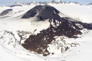
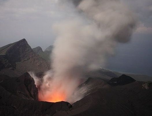
Ecuador / Galapagos Islands , Fernandina :
IG-EPN reported that an eruption at Fernandina began around 2350 on 2 March from a circumferential fissure on the upper SE flank. The fissure possibly propagated 3-5 km and produced a gas emission with low ash content that rose 2-3 km above the summit and drifted W, NNW, and SSE. The emission was detected in satellite data and the fissure was confirmed by pictures shared on social media and reports from Parque Nacional Galápagos. The emissions were intense until about 04h00 on 3 March before decreasing. More than 1,000 thermal anomalies were identified in satellite images during 00h44-01h35 corresponding to multiple lava flows descending the SE flank. Sulfur dioxide emissions were about 46,460 tons per day (t/d) at 13h27 on 3 March, based on satellite data.

During 3-4 March gas plumes with low to no ash content continued to be identified in satellite images, drifting WSW. Hundreds of thermal anomalies were detected in satellite data with some of the intensities of the anomalies being characterized as high, very high, and extreme. Sulfur dioxide emissions had decreased to about 24,000 t/d at 13h27 on 4 March, based on satellite data. Observations by park rangers during 4-5 March indicated that activity had decreased and the lava flows had only advanced slightly. Satellite data indicated that sulfur dioxide emissions continued to decline and were about 2,228 t/d at 12h47 on 5 March. Gas plumes rose 370-970 m above the summit and drifted WSW. Hundreds of thermal anomalies continued to be detected during 5-6 March with a few being characterized as high to very high. The lava flows had traveled as far as 7.9 km based on satellite data and maps.
Sources : GVP , IGEPN .
Photo : John Garate / FB.
Peru , Huaynaputina :
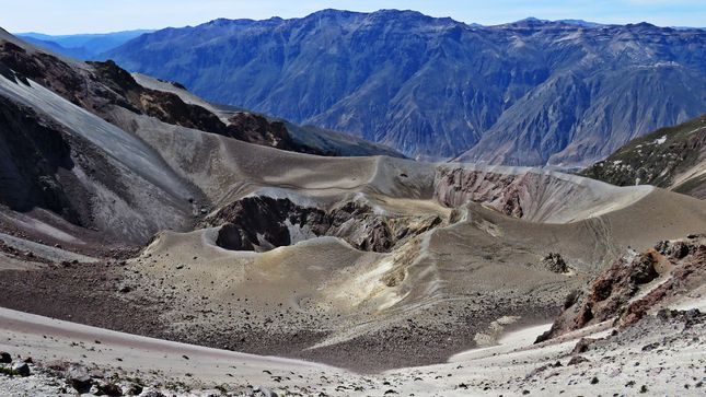
IGP reported that at 16h22 on 29 February and at 14h36 on 3 March lahars descended the El Volcán drainage, on the S flank of Huaynaputina, and traveled towards the Tambo River. The public was warned to stay away from the drainage and to be cautious when traveling along the Quinistaquillas-Sijuaya highway.
Low activity level:
1. 1 earthquake of magnitude less than M2.0, linked to fracturing processes inside the volcano.
2. The descent of a lahar was identified (3:53 p.m.) by the southern sector of the volcano (El Volcán ravine).
3. No building deformation processes are recorded volcanic.
4. No thermal anomalies were detected on the surface of the volcano crater.
5. There are no signs of reactivation or eruptive processes of the volcano in the short term.
RECOMMENDATIONS
1. Stay away from streams and riverbeds adjacent to the volcano due to the possible descent of lahars.
2. Be informed of Huaynaputina activity through IGP reports and bulletins.
3. Implement education and awareness actions regarding the volcanic danger of Huaynaputina
Sources : GVP , IGP
Photo : Ingemmet.
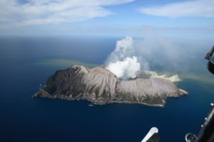
Japan , Suwanosejima :
JMA reported that the eruption at Suwanosejima’s Ontake Crater continued during 26 February-4 March. Crater incandescence was observed in webcam images nightly and large blocks were sometimes ejected up to 600 m from the vent. Explosions recorded at 04h31, 14h02, 19h10, and 19h18 on 26 February, and at 01h35, 02h49, and 06h17 on 27 February produced ash plumes that rose 500-800 m above the crater rim and drifted S. An eruptive event at 01h04 on 28 February produced an ash plume that rose 1.4 km above the crater rim and drifted S. Explosions at 15h37 on 28 February and 00h13 on 2 March generated ash plumes that rose 500-600 m and drifted W and SE, respectively.
An explosion was recorded at 02h55 on 1 March but emission details were unknown. Ash plumes from eruptive events at 15h30 on 3 March and 09h05 on 4 March produced ash plumes that rose 800-1,300 m above the crater rim; the 3 March plume rose into weather clouds. Ashfall was reported in Toshima village (3.5 km SSW), though dates were not specified. The Alert Level remained at 2 (on a 5-level scale) and the public was warned to stay at least 1 km away from the crater.
Sources : GVP , JMA
Photo : Centre culturel et pédagogique « Vulcanarium ». Kamtchatka via FB.
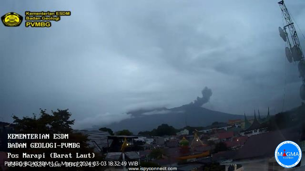
Indonesia , Marapi :
Mount Marapi erupted on Wednesday March 6, 2024 at 01:10 UTC (08:10 WIB). The height of the eruptive column was observed to be ± 700 m above the peak (± 3,591 m above sea level). The ash column was observed to be gray with thick intensity, oriented towards the North and Northwest. The eruption was recorded on a seismograph with a maximum amplitude of 9.2 mm and a duration of 48 seconds.
VOLCANO OBSERVATORY NOTICE FOR AVIATION – VONA
Issued : March 06 , 2024
Volcano : Marapi (261140)
Current Aviation Colour Code : ORANGE
Previous Aviation Colour Code : orange
Source : Marapi Volcano Observatory
Notice Number : 2024MAR025
Volcano Location : S 0 deg 22 min 52 sec E 100 deg 28 min 23 sec
Area : West Sumatra, Indonesia
Summit Elevation : 9251 FT (2891 M)
Volcanic Activity Summary :
Eruption with volcanic ash cloud at 01h10 UTC (08h10 local).
Volcanic Cloud Height :
Best estimate of ash-cloud top is around 11491 FT (3591 M) above sea level or 2240 FT (700 M) above summit. May be higher than what can be observed clearly. Source of height data: ground observer.
Other Volcanic Cloud Information :
Ash cloud moving to north. Volcanic ash is observed to be gray. The intensity of volcanic ash is observed to be thick.
Remarks :
Eruption recorded on seismogram with maximum amplitude 9.2 mm and maximum duration 48 second. Tremor recorded on seismogram with maximum amplitude 2.5 mm.
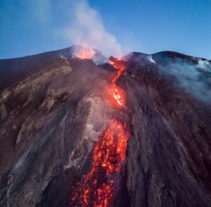
PVMBG reported that eruptive activity at Marapi (on Sumatra) was ongoing during 28 February-5 March. White-and-gray gas-and-ash plumes rose 200-500 m above the summit and drifted in multiple directions on most days; emissions were not observed on 28 February and 5 March. Crater incandescence was visible to residents from multiple directions during the evening of 29 February. The Alert Level remained at 3 (on a scale of 1-4), and the public was warned to stay 4.5 km away from the active crater.
Source : Magma Indonésie. , GVP.
Mexico , Popocatepetl :
March 6, 11:00 a.m. (March 6, 5:00 p.m. GMT). Activity from the last 24 hours
52 exhalations were recorded accompanied by water vapor, other volcanic gases and ash. Additionally, 1,030 minutes of high-frequency, low-amplitude tremors were identified.
CENACOM (National Center for Communications and Civil Protection Operations) reported light ash falls in the municipalities of Santa Isabel Cholula, San Andrés Cholula, San Pedro Cholula, San Gregorio Atzompa, Amozoc, Puebla Capital, Tochimilco, Atlixco, Juan C Bonilla, Nopalucan, San Gregorio Atzompa, Rafael Lara Grajales, San José Chiapa, Santa Clara Ocoyucan and San Juan Cuautlancingo, state of Puebla.
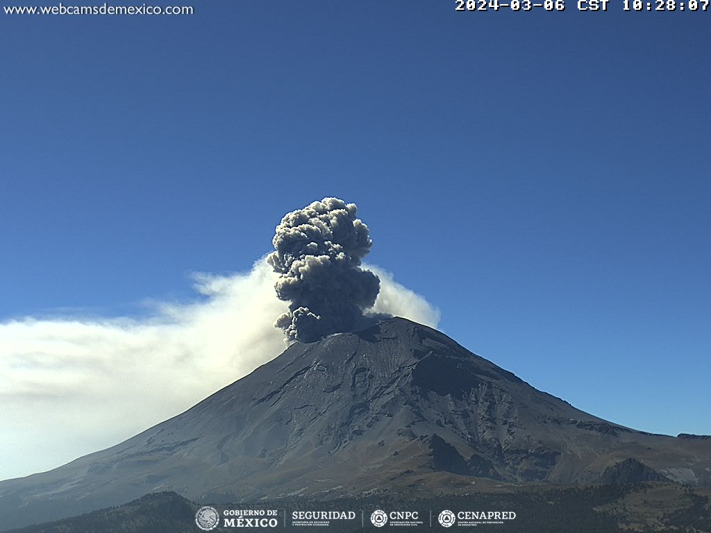
During this morning and at the time of this report, a continuous emission of volcanic gases and ash is observed, with dispersion towards the East-South-East (E-SE).
The Popocatépetl volcanic warning fire is in yellow phase 2.
The scenarios planned for this phase are:
A few small to moderate explosions
Appearance of tremors of variable amplitude
Source : Cenapred.