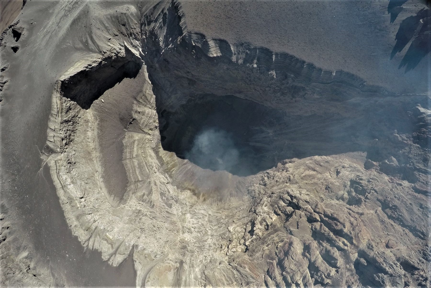
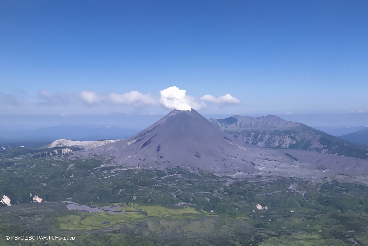
September 14 , 2020 . EN . Philippines : Taal , Indonesia : Semeru , Guatemala : Pacaya , Guadeloupe : La Soufrière .

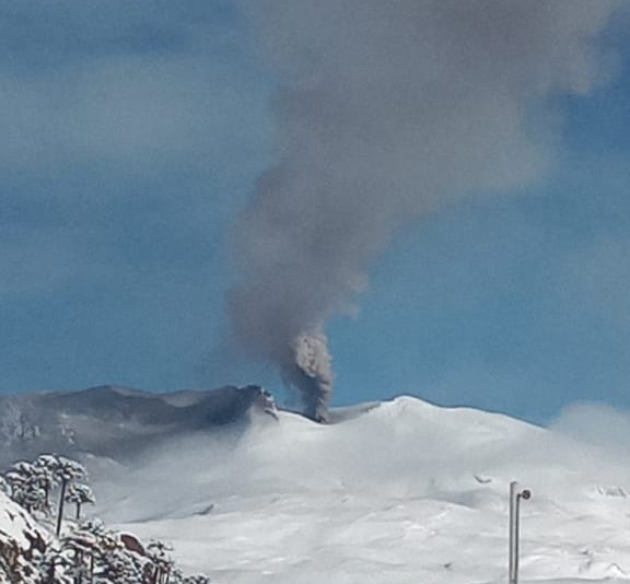
September 14 , 2020 .


Philippines , Taal :

TAAL VOLCANO BULLETIN 14 September 2020 08:00 A.M.

In the past 24-hour period, the Taal Volcano Network recorded six (6) volcanic earthquakes. Very weak steaming or fumarolic activity rising 5 meters high before drifting northwest was observed from fissure vents along the Daang Kastila Trail.

Alert Level 1 (Abnormal) is maintained over Taal Volcano. DOST-PHIVOLCS reminds the public that at Alert Level 1, sudden steam-driven or phreatic explosions, volcanic earthquakes, minor ashfall, and lethal accumulations or expulsions of volcanic gas can occur and threaten areas within the Taal Volcano Island (TVI).


DOST-PHIVOLCS strongly recommends that entry into TVI, Taal’s Permanent Danger Zone or PDZ, especially the vicinities of the Main Crater and the Daang Kastila fissure, must remain strictly prohibited. Local government units are advised to continuously assess previously evacuated barangays around Taal Lake for damages and road accessibilities and to strengthen preparedness, contingency, and communication measures in case of renewed unrest. People are also advised to observe precautions due to ground displacement across fissures, possible ashfall, and minor earthquakes. Civil aviation authorities must advise pilots to avoid flying close to the volcano as airborne ash and ballistic fragments from sudden explosions and wind-remobilized ash may pose hazards to aircraft.

DOST-PHIVOLCS is closely monitoring Taal Volcano’s activity and any new significant development will be immediately communicated to all stakeholders.

Source : Phivolcs .

Photo : Yuri Harmony


Indonesia , Semeru :

VOLCANO OBSERVATORY NOTICE FOR AVIATION – VONA.

Issued : September 14 , 2020 .
Volcano : Semeru (263300)
Current Aviation Colour Code : ORANGE
Previous Aviation Colour Code : orange
Source : Semeru Volcano Observatory
Notice Number : 2020SMR93
Volcano Location : S 08 deg 06 min 29 sec E 112 deg 55 min 12 sec
Area : East java, Indonesia
Summit Elevation : 11763 FT (3676 M)

Volcanic Activity Summary :
Eruption with volcanic ash cloud at 02h49 UTC (09h49local).

Volcanic Cloud Height :
Best estimate of ash-cloud top is around 13043 FT (4076 M) above sea level, may be higher than what can be observed clearly. Source of height data: ground observer.

Other Volcanic Cloud Information :
Ash-cloud moving to south.

Remarks :
Eruption recorded on seismogram with maximum amplitudo 19 mm and duration 82 second

Level of activity at level II ( Waspada). the Semeru (3,676 m above sea level) is continuously erupting. Explosive and effusive eruptions are observed, causing lava flows towards the southern and southeast slopes, as well as explosions of incandescent rocks around the summit crater. The last eruption occurred on September 13, 2020 with the height of the eruption column not observed.

The volcano is clearly visible until it is covered in fog. Smoke from the crater was not observed. The weather is sunny, the winds weak, oriented to the North, South-West and West.

According to the seismographs of September 13, 2020, it was recorded:
– 29 eruption earthquakes
– 5 earthquakes of emissions
– 3 distant tectonic earthquakes.

Recommendation:
1. The community must not carry out activities within a radius of 1 km and in an area of ​​up to 4 km in the sector of the South-South-East slope of the active crater which is the area of ​​the active opening of the crater of Mount Semeru (Jongring Seloko) as a flow of hot clouds.

2. Be aware of the presence of the lava dome in Jongring Seloko Crater.

Source : Magma Indonésie , PVMBG .  

Photo : M. Rietze , wikipedia , licence creative common .


Guatemala , Pacaya :

SPECIAL VOLCANOLOGICAL BULLETIN

Type of activity: Strombolian.
Morphology: composite stratovolcano
Geographical location: 14 ° 22’50˝ Latitude N; 90 ° 36’00˝ Longitude W.
Height: 2,552 meters above sea level.

VOLCANIC ACTIVITY UPDATE
The volcanic activity of the Pacaya volcano recorded last week has been mainly effusive with periods of moderate to strong Strombolian explosiveness that rejects materials up to 200 meters high on the crater. Some of these events generating the fall of ballistic products in a radius of about 50 meters, a constant incandescence and degassing also visible from various points of the city of Guatemala. This degassing generates a plume of white / blue color due to its water and sulfur dioxide composition. The explosive activity maintains the cycle of construction and destruction of the intacrater active cone.

During these last weeks the activity of the lava flows has been maintained on the Northwest and North flanks, with lava flows of different lengths, ranging from 150 meters to 1 km. On the plateau of the northwest flank, in unstable areas, there are still areas of thermal anomalies and cracks from which steam emanates. Currently active lava flows, reported by INSIVUMEH observers, are moving in a northeast direction and another in a northern direction, over 1250 meters and 50 meters, respectively.

The seismic activity recorded by the PCG and PCG5 stations is the same as in recent months when there were periods of greater activity and decrease in it, as well as tremors generated by the movement of lava flows, l rise of magma and the pressure of magmatic gases. See figure n ° 2.

Figure n ° 2: average seismic amplitudes of the PCG station, from September 5 to 11.

The explosive activity generates low to moderate rumblings that vibrate the windows and roofs of houses in the villages of San Francisco de Sales, El Patrocinio, El Rodeo and others, located within a radius of 4 kilometers around the volcano. INSIVUMEH provides visual and instrumental surveillance, by means of a webcam, of seismic stations (PCG and PCG5) and OVPAC observers.

Source : Insivumeh .

Photo : Conred .


Guadeloupe , La Soufrière :

Sunday September 13, 2020 at 1:00 p.m. local time

Sequence of earthquakes in the La Soufrière area of Guadeloupe – Basse Terre.

A sequence of volcanic earthquakes began on Saturday September 12, 2020 at 7.20 a.m. local time (Saturday September 12, 2020 at 11:20 a.m. UTC *) in the area of the volcano of La Soufriere.

Since then, the OVSG-IPGP networks have recorded 75 very low magnitude earthquakes (M <1).
No earthquakes were reported felt. The events are located at a depth of <2.5 km below the top of the dome of La Soufrière.

The alert level remains: yellow, vigilance.

Source : Direction of OVSG-IPGP.

Photo : P Giraud / ctig

September 01 , 2020. EN. Peru : Sabancaya , Peru : Ubinas , Guatemala : Pacaya , Indonesia : Dukono .

September 01 , 2020.


Peru , Sabancaya :

Analysis period: August 24 to 30, 2020, Arequipa, August 31, 2020
Alert level: ORANGE

The Geophysical Institute of Peru (IGP) reports that the eruptive activity of the Sabancaya volcano remains at moderate levels; that is, with the continuous recording of explosions which generated columns of gas and ash during this period. These rose up to 3.5 km above the summit of the volcano and were scattered to the south, south-east and east of Sabancaya. For the following days, no significant change is expected concerning the eruptive activity.


The IGP recorded and analyzed the occurrence of 2,063 earthquakes of volcanic origin associated with the circulation of magmatic fluids on the Sabancaya. In addition, an average of 29 explosions of low to medium intensity was recorded daily. During this period, Volcano-Tectonic (VT) type earthquakes, with a magnitude between M2.2 and M3.7, were located mainly in the North-West area of ​​Sabancaya. The main earthquake (magnitude M3.7) was recorded on August 25 at 8:37 p.m., 14 km north of Sabancaya and at a depth of 15 km. Seismic activity saw a slight increase last week, recording up to 41 explosions on August 30, 2020; however, this activity is within the parameters observed in the current eruptive process of Sabancaya.

Monitoring the deformation of the volcanic structure, using GNSS equipment and data (processed with fast orbits), recorded a slight inflation of the northern sector of Hualca Hualca and the southeast flank of the Sabancaya volcano. Visual surveillance identified columns of gas and ash up to 3.5 km high above the summit of the volcano, which were scattered towards the southern, southeast and eastern sectors of Sabancaya. Satellite monitoring has identified the presence of 4 thermal anomalies with values ​​between 6 MW and 98 MW, associated with the presence of a lava body on the surface of the volcano crater.

RECOMMENDATIONS
• Keep the volcanic alert level in orange.
• Do not approach within a radius of less than 12 km around the crater.

Source : IGP.

Photo : Pixabay


Peru , Ubinas :

Analysis period: August 24 to 30, 2020, Arequipa, August 31, 2020
Alert level: ORANGE

The Geophysical Institute of Peru (IGP) reports that the Ubinas volcano (region of Moquegua) continues to record a slight increase in seismic activity during the analysis period; therefore, it is suggested that the authorities and the public are aware of the bulletins published by the IGP.

During the analysis period, the occurrence of 31 earthquakes of volcanic origin of magnitude less than M1.4 were identified, events associated with rock breaking processes that occur inside the volcano. On average, 4 earthquakes were recorded per day. Likewise, 10 seismic signals were recorded, linked to the movement of volcanic fluids (water vapor and gas).

Surveillance cameras recorded columns of gas (mainly water vapor) reaching heights of up to 600 m above the summit of the volcano, which were then dispersed towards the south-eastern sector of the volcano.
Monitoring the deformation of the volcanic structure, using GNSS equipment and data (processed with fast orbits), shows a slight inflation of the volcano’s surface since early August. Satellite monitoring, carried out through the SENTINEL, OMI-NASA (SO2 gas) and MIROVA (thermal anomalies) systems, did not record any anomalies during the period.

RECOMMENDATIONS
• Stay informed at all times of the activity of the Ubinas volcano thanks to the bulletins issued by the IGP:
• Do not approach within a radius of less than 4 km around the crater.

Source et photo : IGP


Guatemala , Pacaya :

Type of activity: Strombolian.
Morphology: composite stratovolcano
Geographical location: 14 ° 22’50˝ Latitude N; 90 ° 36’00˝ Longitude W.
Height: 2,552 msnm.
Atmospheric conditions: clear
Wind: south-east
Precipitation: 0.60 mm.

Activity:

The Mackenney crater is observed with a white fumarole which disperses towards the West and the North-West. Weak to moderate Strombolian type explosions are recorded which expel incandescent materials from 25 to 100 meters above the crater. A constant incandescence is observed in the crater accompanied by prolonged degassing, which generates thick and tall columns for long periods. Lava flows are observed on the northern flank, also moving in the same direction. The length of the lava flow is between 300 and 450 meters. The previous lava flow in a northeast direction did not exhibit any incandescence or outgassing along its path, which is why it is considered inactive. The INSIVUMEH seismic stations constantly record tremors, associated with the rise of magma, as well as the permanent degassing observed in the crater. The recommendations described in special bulletin no. 62-2020 remain in force.

Source : Insivumeh.

Photo : B. Villela .


Indonesia , Dukono :

VOLCANO OBSERVATORY NOTICE FOR AVIATION – VONA.

Issued : August 31 2020
Volcano : Dukono (268010)
Current Aviation Colour Code : ORANGE
Previous Aviation Colour Code : orange
Source : Dukono Volcano Observatory
Notice Number : 2020DUK76
Volcano Location : N 01 deg 41 min 35 sec E 127 deg 53 min 38 sec
Area : North Maluku, Indonesia
Summit Elevation : 3933 FT (1229 M)

Volcanic Activity Summary :
Eruption with volcanic ash cloud at 02h45 UTC (11h45 local).


Volcanic Cloud Height :
Best estimate of ash-cloud top is around 5213 FT (1629 M) above sea level, may be higher than what can be observed clearly. Source of height data: ground observer.

Other Volcanic Cloud Information : Ash-cloud moving to west

Remarks : Eruption and ash emission is continuing.

Level of activity at level II (WASPADA). The Dukono volcano (1229 m altitude) is in continuous eruption. The last eruption occurred on August 24, 2020, resulting in a column height of 900 meters above the summit. The color of the ash column ranges from white to thick gray.

The volcano was clearly visible until it was covered in fog. The smoke from the crater was observed to be white and gray with a shallow thickness, rising about 100 to 400 meters from the summit. The weather is sunny to cloudy, the wind is weak in the West.

According to the seismographs of August 31, 2020, it was recorded:

Continuous tremor with an amplitude of 0.5 to 4 mm, dominant value of 2 mm
1 Distant Tectonic earthquake.

Source : Magma Indonésie , PVMBG.

Photo : Rainwater Media via Sherine France.

01 Septembre 2020. FR . Pérou : Sabancaya , Pérou : Ubinas , Guatemala : Pacaya , Indonésie : Dukono .

01 Septembre 2020.


Pérou , Sabancaya :

Période d’analyse: du 24 au 30 août 2020, Arequipa, 31 août 2020
Niveau d’alerte: ORANGE

L’Institut géophysique du Pérou (IGP) rapporte que l’activité éruptive du volcan Sabancaya reste à des niveaux modérés; c’est-à-dire avec l’enregistrement continu d’explosions qui ont généré des colonnes de gaz et de cendres au cours de cette période . Celles ci se sont élevées jusqu’à 3,5 km au-dessus du sommet du volcan et ont été dispersées au Sud, au Sud-Est et à l’Est du Sabancaya. Pour les jours suivants, aucun changement significatif n’est attendu concernant l’activité éruptive.


L’IGP a enregistré et analysé l’occurrence de 2 063 tremblements de terre d’origine volcanique associés à la circulation de fluides magmatiques sur le Sabancaya. De plus, une moyenne de 29 explosions d’intensité faible à moyenne a été enregistrée quotidiennement. Au cours de cette période, les tremblements de terre de type Volcano-Tectoniques (VT), d’une magnitude comprise entre M2,2 et M3,7, ont été localisés principalement dans la zone Nord-Ouest du Sabancaya. Le séisme principal (magnitude M3,7) a été enregistré le 25 août à 20h37, à 14 km au Nord du Sabancaya et à une profondeur de 15 km. L’activité sismique a connu une légère augmentation la semaine dernière, enregistrant jusqu’à 41 explosions le 30 août 2020; cependant, cette activité se situe dans les paramètres observés dans le processus éruptif actuel du Sabancaya.

Le suivi de la déformation de la structure volcanique, à l’aide d’équipements et de données GNSS (traités avec des orbites rapides), a enregistré une légère inflation du secteur Nord du Hualca Hualca et du flanc Sud-Est du volcan Sabancaya. La surveillance visuelle a permis d’identifier des colonnes de gaz et de cendres jusqu’à 3,5 km de haut au dessus du sommet du volcan, qui étaient dispersées vers les secteurs Sud, Sud-Est et Est du Sabancaya. La surveillance par satellite a identifié la présence de 4 anomalies thermiques avec des valeurs comprises entre 6 MW et 98 MW, associées à la présence d’un corps de lave à la surface du cratère du volcan.

RECOMMANDATIONS
• Garder le niveau d’alerte volcanique en orange.
• Ne pas s’approcher dans un rayon de moins de 12 km autour du cratère.

Source : IGP.

Photo : Pixabay


Pérou , Ubinas :

Période d’analyse: du 24 au 30 août 2020, Arequipa, 31 août 2020
Niveau d’alerte: ORANGE

L’Institut géophysique du Pérou (IGP) rapporte que le volcan Ubinas (région de Moquegua) continue d’enregistrer une légère augmentation de l’activité sismique pendant la période d’analyse; par conséquent, il est suggéré que les autorités et le public connaissent les bulletins publiés par l’IGP.

Au cours de la période d’analyse, la survenue de 31 tremblements de terre d’origine volcanique d’une magnitude inférieure à M1.4 a été identifiée, événements associés à des processus de bris de roches qui se produisent à l’intérieur du volcan. En moyenne, 4 tremblements de terre ont été enregistrés par jour. De même, 10 signaux sismiques ont été enregistrés, liés au mouvement des fluides volcaniques (vapeur d’eau et gaz).

Les caméras de surveillance ont enregistré des colonnes de gaz (principalement de la vapeur d’eau) atteignant des hauteurs allant jusqu’à 600 m au-dessus du sommet du volcan, qui ont ensuite été dispersées vers le secteur Sud-Est du volcan.
Le suivi de la déformation de la structure volcanique, à l’aide d’équipements et de données GNSS (traitées avec des orbites rapides), montre une légère inflation de la surface du volcan depuis début août. La surveillance par satellite, réalisée à travers les systèmes SENTINEL, OMI-NASA (gaz SO2) et MIROVA (anomalies thermiques), n’a pas enregistré d’anomalies au cours de la période.

RECOMMANDATIONS
• Rester informé à tout moment de l’activité du volcan Ubinas grâce aux bulletins émis par l’IGP:
• Ne pas s’approcher dans un rayon de moins de 4 km autour du cratère.

Source et photo : IGP


Guatemala , Pacaya :

Type d’activité: strombolienne.
Morphologie: stratovolcan composite
Situation géographique: 14 ° 22’50˝ Latitude N; 90 ° 36’00˝ Longitude O.
Hauteur: 2 552 msnm.
Conditions atmosphériques: clair
Vent: sud-est
Précipitations: 0,60 mm.

Activité:

Le cratère Mackenney est observé avec une fumerolle blanche qui se disperse vers l’Ouest et le Nord-Ouest. Des explosions de type strombolien faibles à modérées sont enregistrées qui expulsent des matériaux incandescents de 25 à 100 mètres au-dessus du cratère. Une incandescence constante est observée dans le cratère accompagnée d’un dégazage prolongé, qui génère des colonnes épaisses et hautes pendant de longues périodes. Des coulées de lave sont observées sur le flanc Nord, se déplaçant également dans cette même direction. La longueur de la coulée de lave est comprise entre 300 et 450 mètres. La coulée de lave précédente dans une direction Nord-Est n’a pas présenté d’incandescence ou de dégazage le long de sa trajectoire, c’est pourquoi elle est considérée comme inactive. Les stations sismiques de l’ INSIVUMEH enregistrent constamment des tremors, associés à la remontée du magma, ainsi qu’au dégazage permanent observé dans le cratère. Les recommandations décrites dans le bulletin spécial no. 62-2020 restent en vigueur.

Source : Insivumeh.

Photo : B. Villela .


Indonésie , Dukono :

AVIS D’OBSERVATION DU VOLCAN POUR L’AVIATION – VONA.

Publié: 31 Aout 2020 
Volcan: Dukono (268010)
Code couleur de l’aviation actuel: ORANGE
Code couleur de l’aviation précédent: orange
Source: Observatoire du volcan Dukono
Numéro de l’avis: 2020DUK76
Emplacement du volcan: N 01 deg 41 min 35 sec E 127 deg 53 min 38 sec
Région: North Maluku, Indonésie
Altitude du sommet: 3933 FT (1229 M)

Résumé de l’activité volcanique:
Éruption avec nuage de cendres volcaniques à 02h45 UTC (11h45 local).


Hauteur du nuage volcanique:
La meilleure estimation du sommet des nuages de cendres est d’environ 1629 M (5213 FT) au-dessus du niveau de la mer, ce qui peut être plus élevé que ce qui peut être observé clairement. Source des données d’altitude: observateur au sol.

Autres informations sur les nuages volcaniques: un nuage de cendres se déplaçant vers l’ouest

Remarques: L’éruption et l’émission de cendres se poursuivent.

Niveau d’activité de niveau II (WASPADA). Le volcan Dukono (1229 m d’altitude) est en éruption continue. La dernière éruption s’est produite le 24 août 2020, entraînant une hauteur de colonne de 900 mètres au-dessus du sommet. La couleur de la colonne de cendres va du blanc au gris épais.

Le volcan était clairement visible jusqu’à ce qu’il soit couvert de brouillard. Il a été observé que la fumée issue du cratère était blanche et grise avec une faible épaisseur ,  s’élevant d’environ 100 à 400 mètres du sommet. Le temps est ensoleillé à nuageux, le vent est faible à l’Ouest.

Selon les sismographes du 31 août 2020, il a été enregistré:

Tremor continu d’une amplitude de 0,5 à 4 mm, valeur dominante de 2 mm
1  tremblement de terre Tectonique lointain .

Source : Magma Indonésie , PVMBG.

Photo : Rainwater Media via Sherine France.

August 24 , 2020. EN . Kamchatka : Karymsky , Philippines : Kanlaon , Argentina / Chile : Copahue , Guatemala : Pacaya , Mexico : Popocatepetl .

August 24 ,  2020.


Kamchatka , Karymsky :

VOLCANO OBSERVATORY NOTICE FOR AVIATION (VONA).

Issued: August 24 , 2020
Volcano: Karymsky (CAVW #300130)
Current aviation colour code: YELLOW
Previous aviation colour code: orange
Source: KVERT
Notice Number: 2020-173
Volcano Location: N 54 deg 2 min E 159 deg 26 min
Area: Kamchatka, Russia
Summit Elevation: 4874.08 ft (1486 m)

Volcanic Activity Summary:
A moderate gas-steam activity of the volcano continues. Ash explosions of the volcano were noted last time on 29 July, 2020. The temperature of the thermal anomaly was low in August. KVERT continues to monitor Karymsky volcano.
This gas-steam activity continues. The danger of ash explosions up to 16,400-23,000 ft (5-7 km) a.s.l. is remains. Ongoing activity could affect low-flying aircraft.

Volcanic cloud height: NO ASH CLOUD PRODUSED

Other volcanic cloud information: NO ASH CLOUD PRODUSED


Source : Kvert

Photo : Ivan Nuzhdaev, IVS FEB RAS.


Philippines , Kanlaon :

KANLAON VOLCANO BULLETIN: 24 August 2020 08:00 A.M.

Kanlaon Volcano’s monitoring network recorded twenty-three (23) volcanic earthquakes during the 24-hour observation period. Moderate emission of white steam-laden plumes that rose 200 meters before drifting northwest was observed. Sulfur dioxide (SO2) emission was measured at an average of 549 tonnes/day on 22 August 2020. Ground deformation data from continuous GPS measurements indicate slight inflation of the lower and mid slopes since May 2020, while short-term electronic tilt monitoring on the southeastern flanks recorded inflation on the lower to mid slopes that began on June 21, 2020. These parameters may indicate hydrothermal or magmatic processes occurring beneath the edifice.

DOST-PHIVOLCS would like to remind the public that Kanlaon Volcano is at Alert Level 1, which means that it is at an abnormal condition and has entered a period of unrest. The local government units and the public are strongly reminded that entry into the 4-kilometer radius Permanent Danger Zone (PDZ) must be strictly prohibited due to the further possibilities of sudden and hazardous steam-driven or phreatic eruptions. Civil aviation authorities must also advise pilots to avoid flying close to the volcano’s summit as ejecta from any sudden phreatic eruption can be hazardous to aircraft.

DOST-PHIVOLCS is closely monitoring Kanlaon Volcano’s activity and any new development will be relayed to all concerned.

Source et photo : Phivolcs


Argentina / Chile , Copahue :

VOLCANIC ACTIVITY REPORT, August 1 to 15, 2020

The Servicio Geológico Minero Argentino (SEGEMAR) through its Argentine Volcanic Monitoring Observatory (OAVV) reports that the technical alert level for the Copahue volcano is maintained at the YELLOW level.

In the period evaluated, the Volcano-Tectonic (VT) seismicity continues to show a slight decrease in terms of the number of events and associated energies.
The highest energy event had a local magnitude (ML) of 2.2 and was located 11.8 km northeast (NE) of the crater at a depth of 6.1 km. The seismicity associated with the movements of fluids inside the volcano (LP) was recorded with energy levels lower than the previous period, identifying 9 events of this type.
One (1) discrete tremor event (TR) associated with sustained fluid dynamics was recorded in the most superficial sectors, near the crater, with a maximum reduced displacement (DR) of 1.5 cm2.


Since August 6, a continuous tremor with characteristics similar to those observed on July 17 has been detected.
The images provided by the IP cameras made it possible to observe the columns of degassing and materials of whitish / greyish coloring reaching 600 meters above the crater. In addition, a nocturnal incandescence could be identified

Four anomalies of sulfur dioxide (SO2) emissions into the atmosphere were reported on July 6, 10, 11 and 12.
A thermal alert associated with the crater was recorded on August 9. In addition, images from the Sentinel 2-L2A satellite made it possible to identify radiation anomalies on August 8 and 11.
The SO2 emissions recorded on the surface by the DOAS stations showed average values of 1523 tons / day with a maximum value of 4498 tons / day on August 12, a value considered high for this volcano.

RECOMMENDATIONS
The impacted area is considered to be that close to the crater with a radius of 1000 m.
Stay informed and avoid approaching the crater of the volcano.
Receive information only from official media.
It should be noted that the areas near the volcano may be affected by the fall of volcanic ash.
It is suggested to find out about the preventive measures from the civil protection authorities in towns near the volcano.
Examination of the emergency plans of neighboring towns.

Source : Segemar .

Photos : OAVV , Dario G. Lazo .


Guatemala , Pacaya :

Type of activity: Strombolian.
Morphology: composite stratovolcano
Geographical location: 14 ° 22’50˝ Latitude N; 90 ° 36’00˝ Longitude W.
Height: 2,552 msnm.
Weather conditions: Cloudy
Wind: South-West at 30 km / h
Precipitation: 5.6 mm.

Activity:
During the night and early in the morning, weak to moderate Strombolian explosions were observed which raised incandescent materials and ash to a height of 150 meters above the crater. There is a white degassing fumarole at low altitude which moves eastward over a length of about 2 kilometers.  The PCG and PCG5 seismic stations record a constant tremor due to the rise of magma and gases towards the surface. At night and early in the morning, the incandescent reflection of the active lava flow which moves in the middle part of the northeast flank for a length of approximately 300 meters was observed. The recommendations of the special BEPAC bulletin n ° 58-2020 remain valid

Source : Insivumeh.

Photo : David Rojas


Mexico , Popocatepetl :

August 23, 11:00 a.m. (August 23, 4:00 p.m. GMT)

Over the past 24 hours, the Popocatepetl volcano monitoring system has identified 153 exhalations accompanied by volcanic gases and sometimes small amounts of ash. In addition, 840 minutes of low amplitude tremor associated with the constant emission of water vapor, gas with low ash content were recorded.


During the night, an incandescence was observed inside the crater, as well as the constant emission of water vapor and gas in a south-easterly direction, which continues until the time of this report.

CENAPRED urges NOT TO APPROACH the volcano and especially the crater, because of the danger posed by the fall of ballistic fragments, and in the event of heavy rains, to stay away from the bottom of the ravines because of the danger of lava flows. mud and debris.

The Popocatépetl volcanic alert semaphore is in YELLOW PHASE 2.

Source : Cenapred .

24 Aout 2020. FR . Kamchatka : Karymsky , Philippines : Kanlaon , Argentine / Chili : Copahue , Guatemala : Pacaya , Mexique : Popocatepetl .

24 Aout 2020.


Kamchatka , Karymsky :

AVIS D’OBSERVATION DU VOLCAN POUR L’AVIATION (VONA).

Diffusion: 24 août 2020
Volcan: Karymsky (CAVW # 300130)
Code couleur actuel de l’aviation: JAUNE
Code couleur de l’aviation précédent: orange
Source: KVERT
Numéro de l’avis: 2020-173
Emplacement du volcan: N 54 ° 2 min E 159 ° 26 min
Région: Kamchatka, Russie
Altitude du sommet: 4874,08 pi (1486 m).

Résumé de l’activité volcanique:
Une activité gaz-vapeur modérée du volcan se poursuit. Des explosions de cendres du volcan ont été notées la dernière fois le 29 juillet 2020. La température de l’anomalie thermique était basse en août. Le KVERT continue de surveiller le volcan Karymsky.
Cette activité gaz-vapeur se poursuit. Le danger d’explosion de cendres jusqu’à 16 400-23 000 pieds (5-7 km) d’altitude persiste . L’activité en cours pourrait affecter les aéronefs volant à basse altitude.

Hauteur des nuages volcaniques: AUCUN NUAGE DE CENDRES PRODUIT

Autres informations sur les nuages volcaniques: AUCUN NUAGE DE CENDRES PRODUIT.

Source : Kvert

Photo : Ivan Nuzhdaev, IVS FEB RAS.


Philippines , Kanlaon :

BULLETIN D’ACTIVITE DU VOLCAN  KANLAON , 24 août 2020 , 08h00 .

Le réseau de surveillance du volcan Kanlaon a enregistré vingt-trois (23) tremblements de terre volcaniques au cours de la période d’observation de 24 heures. On a observé une émission modérée de panaches blancs chargés de vapeur qui s’élevaient de 200 mètres avant de dériver vers le Nord-Ouest. Les émissions de dioxyde de soufre (SO2) ont été mesurées à une moyenne de 549 tonnes / jour le 22 août 2020. Les données de déformation du sol provenant de mesures GPS continues indiquent une légère inflation des pentes inférieures et moyennes depuis mai 2020, tandis que la surveillance électronique de l’inclinaison à court terme sur  les flancs Sud-Est ont enregistré une inflation sur les pentes inférieures à moyennes qui a commencé le 21 juin 2020. Ces paramètres peuvent indiquer des processus hydrothermaux ou magmatiques se produisant sous l’édifice.

Le DOST-PHIVOLCS souhaite rappeler au public que le volcan Kanlaon est au niveau d’alerte 1, ce qui signifie qu’il est dans un état anormal et qu’il est entré dans une période de troubles. Il est vivement rappelé aux autorités locales et au public que l’entrée dans la zone de danger permanent (PDZ) d’un rayon de 4 kilomètres doit être strictement interdite en raison de possibilités d’éruptions soudaines et dangereuses causées par la vapeur ou phréatiques. Les autorités de l’aviation civile doivent également conseiller aux pilotes d’éviter de voler à proximité du sommet du volcan car les éjections de toute éruption phréatique soudaine peuvent être dangereuses pour les aéronefs.

Le DOST-PHIVOLCS surveille de près l’activité du volcan Kanlaon et tout nouveau développement sera relayé à toutes les parties concernées.

Source et photo : Phivolcs


Argentine / Chili , Copahue :

RAPPORT D’ACTIVITÉ VOLCANIQUE, du 1er au 15 août 2020

Le Servicio Geológico Minero Argentino (SEGEMAR) par le biais de son Observatoire argentin de surveillance volcanique (OAVV) rapporte que le niveau d’alerte technique pour le volcan Copahue est maintenu  au niveau JAUNE.

Dans la période évaluée, la sismicité de type Volcano-Tectonique (VT) continue d’afficher une légère diminution en termes de nombre d’événements et d’énergies associées.
L’événement d’énergie la plus élevée avait une magnitude locale (ML) de 2,2 et était situé à 11,8 km au Nord-Est (NE) du cratère à une profondeur de 6,1 km. La sismicité associée aux mouvements des fluides à l’intérieur du volcan (LP) a été enregistrée avec des niveaux d’énergie inférieurs à la période précédente, identifiant 9 événements de ce type.
Un (1) événement de tremor discret (TR) associé à une dynamique des fluides soutenue a été enregistré dans les secteurs les plus superficiels , près du cratère, avec un déplacement réduit maximum (DR) de 1,5 cm2 .


Depuis le 6 août, un tremor continu avec des caractéristiques similaires à celles observées le 17 juillet a été détecté.
Les images fournies par les caméras IP ont permis d’observer les colonnes de dégazage et de matériaux de coloration blanchâtre / grisâtre atteignant 600 mètres au-dessus du cratère. De plus, une incandescence nocturne pouvait être identifiée

Quatre anomalies d’émissions de dioxyde de soufre (SO2) dans l’atmosphère ont été signalées les 6, 10, 11 et 12 juillet.
Une alerte thermique associée au cratère a été enregistrée le 9 août. De plus, les images du satellite Sentinel 2-L2A ont permis d’identifier des anomalies de rayonnement les 8 et 11 août.
Les émissions de SO2 enregistrées en surface par les stations DOAS ont montré des valeurs moyennes de 1523 tonnes / jour avec une valeur maximale de 4498 tonnes / jour le 12 août, valeur jugée élevée pour ce volcan.

RECOMMANDATIONS
La zone impactée est considérée comme celle proche du cratère avec un rayon de 1000 m.
Rester informé et éviter de s’ approcher du cratère du volcan.
Recevoir des informations uniquement des médias officiels.
Il est à noter que les zones proches du volcan peuvent être affectées par la chute de cendres volcaniques.
Il est suggéré de se renseigner sur les mesures de prévention auprès des autorités de protection civile des villes proches du volcan.
Examen des plans d’urgence des villes voisines.

Source : Segemar .

Photos : OAVV , Dario G. Lazo .


Guatemala , Pacaya :

Type d’activité: strombolienne.
Morphologie: stratovolcan  composite
Situation géographique: 14 ° 22’50˝ Latitude N; 90 ° 36’00˝ Longitude O.
Hauteur: 2 552 msnm.
Conditions atmosphériques: Nuageux
Vent: Sud-Ouest à 30 km / h
Précipitations: 5,6 mm.

Activité :
Pendant la nuit et tôt le matin, des explosions stromboliennes faibles à modérées ont été observées qui soulèvent des matériaux incandescents et des cendres à une hauteur de 150 mètres au-dessus du cratère. On note une fumerolle blanche de dégazage à basse altitude qui se déplace vers l’Est sur une longueur d’environ 2 kilomètres. . Les stations sismiques PCG et PCG5 enregistrent un tremor constant dû à la remontée du magma et des gaz vers la surface. La nuit et tôt le matin, le reflet incandescent de la coulée de lave active qui se déplace dans la partie médiane du flanc Nord-Est sur une longueur approximative de 300 mètres a été observé. Les recommandations du bulletin spécial BEPAC n ° 58-2020 restent valables

Source : Insivumeh.

Photo : David Rojas


Mexique , Popocatepetl :

23 août, 11h00 (23 août, 16h00 GMT)

Au cours des dernières 24 heures, le système de surveillance du volcan Popocatepetl a identifié 153 exhalaisons accompagnées de gaz volcaniques et parfois de faibles quantités de cendres . De plus, 840 minutes de tremor de faible amplitude associées à l’émission constante de vapeur d’eau, de gaz avec de faible teneur en cendres ont été enregistrées .


Pendant la nuit, une incandescence a été observée à l’intérieur du cratère , ainsi que l’émission constante de vapeur d’eau et de gaz dans une direction Sud-Est, qui perdure jusqu’au moment de ce rapport.

Le CENAPRED exhorte à NE PAS APPROCHER le volcan et surtout le cratère, en raison du danger posé par la chute de fragments balistiques,  et en cas de fortes pluies, de rester à l’écart du fond des ravins en raison du danger des coulées de boue et de débris.

Le sémaphore d’alerte volcanique du Popocatépetl est en PHASE JAUNE 2.

Source : Cenapred .

July 25, 2020. EN . Argentina / Chile : Copahue , Indonesia : Merapi , Guatemala : Pacaya , La Reunion : Earthquake felt .

July 25 , 2020. 


Argentina / Chile , Copahue :

The Argentine Geological Mining Service (SEGEMAR) through its Argentine Volcanic Monitoring Observatory (OAVV) and jointly with the Volcanological Observatory of the Southern Andes (OVDAS) of Chile, report that from July 23, the level of technical alert for the Copahue volcano is raised to YELLOW level.

Although the Copahue volcano has exhibited low levels of seismic activity over the past 15 days, the increase in the continuous tremor seismic signal recorded on July 16, which was accompanied at the surface by the emission of low ash magnitude, which continues to this day, to which is added the apparent increase in gas emission (SO2) that the volcano manifests, suggest an instability of the volcanic system associated with an underlying heat source that destabilizes the system hydrothermal inducing a possible collapse of the crater lake.

In this context, there is a high probability that the volcanic system can generate new episodes of gas emissions and low-rise ash columns. This does not mean an impending major eruption, but an increase in surface activity and certain monitoring parameters, which are above its baseline level, implying that more careful monitoring of the activity of the volcano must be performed.

The Copahue volcano is the most active volcano in the Republic, according to the Relative Risk Classification of the Argentine Republic, prepared by SEGEMAR, and is a volcano that constantly presents this type of activity, without this implying a direct risk for them. nearby populations. For this reason, monitoring the volcano and permanent communication with the civil protection authorities of the province and the municipality are of vital importance.

It is recommended to stay informed by the official media of the preventive measures taken by the civil protection authorities of the towns near the volcano in Argentinian territory.

Joint monitoring and cooperation tasks will continue with the Volcanological Observatory of the Southern Andes (OVDAS) in Chile, as well as with local and provincial authorities, and any changes will be reported.

Source : Segemar .

Photos : Segemar , Sernageomin .


Indonesia , Merapi :

Activity report of the Merapi volcano, from July 17 to 23, 2020.

OBSERVATION RESULTS.
Visual
The weather around Mount Merapi is generally sunny in the morning and night, while the day until evening is foggy. There is white smoke, thin to thick with low pressure. A maximum of 200 m in height of smoke was observed from the Mount Merapi observation post in Kaliurang on July 22, 2020 at 9:37 a.m.
Morphological analysis of the crater area based on photos of the southeast sector did not show any change in the morphology of the dome. The volume of the lava dome based on measurements using aerial drone photography on July 11, 2020 is estimated at 200,000 m3.

Seismicity:

During this week, the seismicity of the Merapi recorded:
13 earthquakes of emissions (DG),
12 shallow volcanic earthquakes (VTB),
55 Multiple Phase (MP) earthquakes,
4 low frequency earthquakes (LF),
28 avalanche earthquakes. (RF),
20 tectonic earthquakes (TT).

The seismic intensity this week is relatively lower than last week.


Deformation:
The deformity of G. Merapi which was monitored using EDM this week showed a distance shortening of about 1 cm.

Rain and lahars:
This week there have been no reports of rain and lahars, nor additional flows in the rivers flowing down from Mount Merapi.

Conclusion
Based on the results of visual and instrumental observations, it was concluded that:
1. The lava dome is currently in stable condition.
2. The volcanic activity of Mount Merapi is still quite high and determined by the level of “WASPADA” activity.
3. The danger potential today is in the form of hot clouds from the collapse of the lava dome and explosion of volcanic material from explosive eruptions.

Source : BPPTKG.

Photos : Magma Indonesia , Martin Fontaine.


Guatemala , Pacaya :

Type of activity: Strombolian.
Morphology: composite stratovolcano
Geographical location: latitude 14 ° 22’50˝ N; 90 ° 36’00˝ west longitude
Height: 2,552 m.
Atmospheric conditions: clear
Wind: North-West at 2 km / h
Precipitation: 0.0 mm.

Activity:
The Mackenney crater is observed, with a blue / white degassing fumarole that the wind moves south and southwest over a distance of up to 3 kilometers. This is accompanied by Strombolian explosions which expel incandescent materials to heights of 50, 75 and 100 meters above the crater. The seismic stations of INSIVUMEH constantly record tremors and explosions, with a tendency to increase energy in the last hours. This is due to the rise and extrusion of magma and gas to the surface. Three lava flows with a length of between 200 and 300 meters are observed located at the base of the Mackenney cone in a northwest direction. The recommendations of the special BEPAC bulletin n ° 47-2020 remain in force.

Source : Insivumeh .

Photo : Sentinel .


La Réunion , Earthquake felt :

Bulletin for Friday July 24, 2020 at 7:00 p.m. (local time) – felt earthquake

On Friday July 24, 2020, 4:19 p.m. (local time – 12:19 GMT), an earthquake was felt by residents of the island, mainly in the North.

This earthquake was recorded by the seismometers of the Volcanological Observatory of Piton de la Fournaise. The first analyzes of this earthquake made it possible to locate it, 11 km below sea level, 7 km west southwest of Sainte-Clotilde. Its magnitude was measured at 1.9 on the Richter scale.

This type of event, felt by the population, is recorded several times a year. This event is isolated and is of tectonic origin.

Call for testimonies on felt earthquakes: the real intensities (effects of an earthquake in a given location) can only be correctly determined by collecting testimonies. If you have felt this earthquake, even weakly, you are invited to report it to the BCSF (Bureau Central Sismologique Français) on the site  http://www.franceseisme.fr/

Source : OVPF

Photo : Nath Duverlie

25 Juillet 2020. FR . Argentine / Chili : Copahue , Indonésie : Merapi , Guatemala : Pacaya , La Réunion : Séisme Ressenti .

25 Juillet 2020. 


Argentine / Chili , Copahue :

Le Service minier géologique argentin (SEGEMAR) par le biais de son Observatoire argentin de surveillance volcanique (OAVV) et conjointement avec l’Observatoire volcanologique des Andes méridionales (OVDAS) du Chili, signalent qu’à partir du 23 Juillet, le niveau d’alerte technique pour le volcan Copahue est relevé au niveau JAUNE.

Bien que le volcan Copahue ait présenté de faibles niveaux d’activité sismique au cours des 15 derniers jours, l’augmentation du signal sismique de tremor continu enregistré le 16 juillet, qui s’est accompagnée en surface par l’émission de cendres de faible ampleur , qui se maintient à ce jour, auquel s’ajoute l’augmentation apparente de l’émission de gaz (SO2 ) que le volcan manifeste, suggèrent une instabilité du système volcanique associée à une source de chaleur sous-jacente qui déstabilise le système hydrothermal induisant un possible effondrement du lac de cratère.

Dans ce contexte, il y a une forte probabilité que le système volcanique puisse générer de nouveaux épisodes d’émissions de gaz et des colonnes de cendres de faible hauteur. Cela ne signifie pas une éruption majeure imminente, mais une augmentation de l’activité de surface et de certains paramètres de surveillance, qui sont au-dessus de son niveau de base, ce qui implique qu’une surveillance plus attentive de l’activité du volcan doit être effectuée.

Le volcan Copahue est le volcan le plus actif de la République, selon le Classement des risques relatifs de la République argentine, préparé par SEGEMAR, et est un volcan qui présente constamment ce type d’activité, sans que cela implique un risque direct pour les populations proches. Pour cette raison, la surveillance du volcan et la communication permanente avec les autorités de protection civile de la province et de la municipalité sont d’une importance vitale.

Il est recommandé de rester informé par les médias officiels des mesures préventives prises par les autorités de protection civile des villes proches du volcan en territoire argentin.

Les tâches conjointes de suivi et de coopération se poursuivront avec l’Observatoire volcanologique des Andes méridionales (OVDAS) au Chili, ainsi qu’avec les autorités locales et provinciales, et tout changement sera signalé.

Source : Segemar .

Photos : Segemar , Sernageomin .


Indonésie , Merapi :

Rapport d’activité du volcan Merapi, du 17 au 23 juillet 2020 .

RÉSULTATS DE L’OBSERVATION.
Visuel
Le temps autour du mont Merapi est généralement ensoleillé le matin et la nuit, tandis que la journée jusqu’au soir est brumeuse. On note une fumée blanche, d’épaisseur faible à épaisse avec une faible pression. Un maximum de 200 m de hauteur de fumée a été observé depuis le poste d’observation du mont Merapi à Kaliurang le 22 juillet 2020 à 09h37  .
L’analyse morphologique de la zone du cratère basée sur des photos du secteur Sud-Est n’a pas montré de changement dans la morphologie du dôme. Le volume du dôme de lave basé sur des mesures utilisant la photographie aérienne avec drone le 11 juillet 2020 est estimé à 200 000 m3.

Sismicité :

Au cours de cette semaine, la sismicité du Merapi a enregistré:
13 séismes d’émissions (DG),
12 tremblements de terre volcaniques peu profond (VTB),
55 tremblements de terre de Phase Multiples (MP),
4  tremblements de terre basse fréquence (LF),
28 tremblements de terre d’avalanches .(RF),
20 séismes tectonique (TT).

L’intensité sismique cette semaine est relativement plus faible que la semaine dernière.


Déformation:
La déformation du G. Merapi qui a été surveillée à l’aide de l’EDM cette semaine a montré un raccourcissement de distance d’environ 1 cm.

Pluie et lahars :
Cette semaine, il n’y a pas eu de rapports de pluie et de lahars, ni de flux supplémentaires dans les rivières qui descendent du mont Merapi.

Conclusion
Sur la base des résultats des observations visuelles et instrumentales, il a été conclu que:
1. Le dôme de lave est actuellement dans un état stable.
2. L’activité volcanique du mont Merapi est encore assez élevée et déterminée par le niveau d’activité « WASPADA ».
3. Le potentiel de danger aujourd’hui se présente sous la forme de nuages chauds provenant de l’effondrement du dôme de lave et d’ explosion de matière volcanique provenant d’éruptions explosives.

Source : BPPTKG.

Photos : Magma Indonesia , Martin Fontaine.


Guatemala , Pacaya :

Type d’activité: Strombolienne.
Morphologie: stratovolcan  composite
Situation géographique: 14 ° 22’50˝ de latitude N; 90 ° 36’00˝ de longitude ouest
Hauteur: 2,552 m.
Conditions atmosphériques: clair
Vent: Du Nord-Ouest à 2 km / h
Précipitations: 0,0 mm.

Activité:
Le cratère Mackenney est observé, avec une fumerolle de dégazage bleue / blanche que le vent déplace vers le Sud et le Sud-Ouest sur une distance allant jusqu’à 3 kilomètres. Cela s’accompagne d’explosions stromboliennes qui expulsent des matériaux incandescents à des hauteurs de 50, 75 et 100 mètres au-dessus du cratère. Les stations sismiques de l’INSIVUMEH enregistrent constamment des tremors et des explosions, avec une tendance à l’augmentation de l’énergie au cours des dernières heures. Cela est dû à la remontée et à l’extrusion de magma et de gaz à la surface. Trois coulées de lave d’une longueur comprise entre 200 et 300 mètres sont observées situées à la base du cône Mackenney dans une direction Nord-Ouest. Les recommandations du bulletin spécial BEPAC n ° 47-2020 restent en vigueur.

Source : Insivumeh .

Photo : Sentinel .


La Réunion , Séisme Ressenti :

Bulletin du vendredi 24 juillet 2020 à 19h00 (Heure locale) – séisme ressenti

Le vendredi 24 juillet 2020, 16h19 (Heure locale – soit 12h19 TU), un séisme a été ressenti par des habitants de l’île, principalement dans le Nord.

Ce séisme a été enregistré par les sismomètres de l’Observatoire Volcanologique du Piton de la Fournaise. Les premières analyses de ce séisme ont permis de le localiser, à 11 km sous le niveau de la mer, à 7 km à l’ouest sud-ouest de Sainte-Clotilde. Sa magnitude a été mesurée à 1.9 sur l’échelle de Richter.

Ce type d’événements, ressenti par la population est enregistré plusieurs fois par an. Cet événement est isolé et est d’origine tectonique.

Appel à témoignages sur les séismes ressentis: les intensités réelles (effets d’un séisme en un lieu donné) ne peuvent être correctement déterminées que par recueil de témoignages. Si vous avez ressenti ce séisme, même faiblement, vous êtes invité à le signaler au BCSF (Bureau Central Sismologique Français) sur le site http://www.franceseisme.fr/

Source : OVPF

Photo : Nath Duverlie

July 23, 2020. EN . Italy / Sicily : Etna , Japan : Nishinoshima , Kadovar : Papua New Guinea , Ecuador : Reventador , Guatemala : Pacaya .

July 23 , 2020.


Italy / Sicily , Etna :

ETNA PRESS RELEASE [UPDATE n. 61]

The National Institute of Geophysics and Volcanology, Etneo Osservatorio, reports that in recent hours a slight increase in explosive activity has been observed, mainly at the New Southeast Crater (NSEC), with a slight increase in the frequency of explosions and ash emissions, which quickly disperses in the summit area. It should be noted that this activity has however a variable intensity, as observed in the previous press release (n ° 60).

The amplitude of the volcanic tremor shows oscillations around the average values and in particular there was a decay phase from 19:30 UTC. The location of the source of the tremor does not show significant variations, resulting in the New Southeast Crater (NSEC) area, at an altitude of 2900-3000 m above sea level.
The deformations of the ground show no significant variation.

Further updates will be communicated shortly.

Source : INGV .


Japan , Nishinoshima :

27.247°N, 140.874°E
Elevation 25 m

JMA scientists observed Nishinoshima from a ship on 11 July. They reported that a large amount of ash was emitted from the summit crater; plumes rose about 1.7 km and drifted W, dropping ash into the sea. Deposits of large blocks at the foot of the cone were visible. Lava fountains that rose 200 m above the crater were observable at night, along with lightning in the ash plumes. The cone had grown to about 200 m, about 40 m higher than an estimate on 1 December 2019. The report stated that ships should stay at least 2.5 km away from the cone.

Based on satellite data and pilot observations, the Tokyo VAAC reported that during 16-21 July ash plumes rose to 3.7-6.4 km (12,000-21,000 ft) a.s.l. and drifted N, NE, and E. Satellite data showed a sulfur dioxide plume reaching the western USA on 18 July, after traveling over 9,000 km from Nishinoshima.

Sources: Japan Meteorological Agency (JMA), Tokyo Volcanic Ash Advisory Center (VAAC), Simon Carn , GVP .

Photo : Osamu Kobayashi via Sherine France .


Kadovar , Papua New Guinea :

3.608 ° S, 144.588 ° E
Elevation : 365 m

RVO reported minor eruptive activity at Kadovar during 1-15 July consisting of occasional light gray ash plumes of variable densities rising a few hundred meters above the summit crater. Fluctuating summit incandescence was visible at night. Activity intensified on 5 July as emissions became dark gray and dense. Explosions at 16h52 and 18h15 generated dense dark gray ash plumes that rose 1 km and drifted W.

Loud rumbling accompanied the explosion. Activity subsided later that day but was again more intense during 8-10 July. Explosions recorded at 20h45 on 8 July, 11h45 and 14h00 on 9 July, and at 09h50 and 11h25 on 10 July produced ash plumes that rose 1 km above the summit.

Source: Observatoire du volcan Rabaul (RVO).

Photo : Philippe Stern , eruption archive 2018.


Ecuador , Reventador :

DAILY REPORT OF THE STATE OF THE REVENTADOR VOLCANO, Wednesday July 22, 2020.
Information Geophysical Institute – EPN.

Surface activity level: High, Surface trend: Increasing.
Internal activity level: High, Internal trend: No change.

Seismicity: There is no seismicity data.

Rains / lahars: There were no rains in the area.


Emission / ash column: Several gas and ash emissions were observed in the morning, the height of which varied from 800 m to 1000 m above the crater level; their direction went from west to northwest. The Washington VAAC reported 4 alerts of emissions observed by the satellites which continued to move west. Their height did not exceed 1000 meters above the level of the crater.

Other monitoring parameters: no change.

Observations: On rare occasions, when the volcano cleared, gas and ash emissions were observed. At night, an incandescence was observed in the crater, explosions occurred which generated a rolling of blocks on the sides of the volcano up to 800 m below the level of the crater. Pyroclastic deposits have been identified on the northern flank up to 600 m below the crater level. There is no seismic data due to data transmission problems from the reference station.

Niveau d’alerte: Orange.

Source : IGEPN.

Photo : Martin Rietze .


Guatemala , Pacaya :

SPECIAL BEPAC VOLCANOLOGICAL BULLETIN # 47-2020

Type of activity: Strombolian.
Morphology: composite stratovolcano
Geographical location: 14 ° 22’50˝ North Latitude; 90 ° 36’00˝ Longitude West
Height: 2552 m.

The Pacaya volcano, according to observations made in the field on the 21st of this month and the recording of the PCG and PCG5 seismic stations, has shown a gradual increase in its activity over the last few hours. As a result of this increase, permanent degassing and incandescence is observed in the Mackenney crater, as well as lava flows and weak to moderate explosions. The following graph represents the seismic energy released from July 9 to 21 and indicates that the increase has been gradual over the last few hours, reaching values close to 10,000 RSAM in amplitude.

Seismic amplitude recorded by the PCG station, vertical component.

The activity of recent lava flows inside the plateau continues, in the vicinity of the northwest flank, they have a length of about 300 m. These lava flows flow at high temperatures giving off an odor of sulfur. In figure no. 2 It is possible to observe the displacement, direction and relative temperature of the flows, which allows us to observe which areas of the flow remain hotter than others. These can stay at high temperatures for several weeks or months. Continuous explosions in the crater partly generate the destruction of the slag cone formed by the Strombolian explosions of the daily activity of the Mackenney crater. During certain periods of a few minutes to a few hours, a column of gas and ash is visualized at a height of 2800 meters above sea level (9186 feet) which moves towards the southwest flank, reaching distances of up to approximately 7 kilometers.

Figure no. 2: FLIR thermal image. Temp. Realtive.

Increase observed in the last hours.

The explosive activity generates low to moderate rumblings that vibrate the windows and roofs of houses in the villages of San Francisco de Sales, El Patrocinio, El Rodeo, and others, located 4 kilometers from the volcano.

The INSIVUMEH, provides visual and instrumental monitoring, through a webcam and the PCG and PCG5 stations, which record the seismic activity generated by the Pacaya volcano.

Source : Insivumeh

23 Juillet 2020. FR . Italie / Sicile : Etna , Japon : Nishinoshima , Kadovar : Papouasie Nouvelle Guinée , Equateur : Reventador , Guatemala : Pacaya .

23 Juillet 2020.


Italie / Sicile , Etna :

COMMUNIQUÉ DE PRESSE ETNA [MISE À JOUR n. 61]

L’Institut national de géophysique et de volcanologie, Etneo Osservatorio, rapporte qu’au cours des dernières heures, une légère augmentation de l’activité explosive a été observée, principalement au Nouveau Cratère Sud-Est (NSEC ), avec une légère augmentation de la fréquence des explosions et des émissions de cendres, qui se disperse rapidement dans la zone du sommet. Il est à noter que cette activité a cependant une intensité variable, comme observé dans le communiqué de presse précédent (n ° 60).

L’amplitude du tremor volcanique montre des oscillations autour des valeurs moyennes et en particulier il y a eu une phase de décroissance à partir de 19h30 UTC. L’emplacement de la source du tremor ne montre pas de variations significatives, résultant dans la zone du Nouveau Cratère Sud-Est (NSEC), à une altitude de 2900-3000 m au-dessus du niveau de la mer.
Les déformations du sol ne montrent aucune variation significative.

D’autres mises à jour seront communiquées rapidement.

Source : INGV .


Japon , Nishinoshima :

27,247 ° N, 140,874 ° E
Élévation 25 m

Les scientifiques du JMA ont observé Nishinoshima depuis un navire le 11 juillet. Ils ont rapporté qu’une grande quantité de cendres avait été émise par le cratère sommital; les panaches se sont élevés d’environ 1,7 km et ont dérivé vers l’Ouest, laissant tomber des cendres dans la mer. Des dépôts de gros blocs au pied du cône étaient visibles. Les fontaines de lave qui s’élevaient à 200 m au-dessus du cratère étaient observables la nuit, ainsi que la foudre dans les panaches de cendres. Le cône avait atteint environ 200 m, soit environ 40 m de plus qu’une estimation au 1er décembre 2019. Le rapport indiquait que les navires devraient rester à au moins 2,5 km du cône.

Sur la base de données satellitaires et d’observations pilotes, le Tokyo VAAC a rapporté que du 16 au 21 juillet, les panaches de cendres se sont élevés de 3,7 à 6,4 km (12000-21000 pieds) d’altitude et ont dérivé vers le Nord, Nord-Est et Est. Les données satellitaires ont montré un panache de dioxyde de soufre atteignant l’Ouest des États-Unis le 18 juillet, après avoir parcouru plus de 9 000 km depuis Nishinoshima.

Sources: Agence météorologique japonaise (JMA), Centre consultatif des cendres volcaniques de Tokyo (VAAC), Simon Carn , GVP .

Photo : Osamu Kobayashi via Sherine France .


Kadovar , Papouasie Nouvelle Guinée :

3.608 ° S, 144.588 ° E
Dénivelé 365 m

Le RVO a signalé une activité éruptive mineure sur Kadovar du 1er au 15 juillet consistant en quelques panaches de cendres gris clair de densités variables s’élevant à quelques centaines de mètres au-dessus du cratère sommital. Une incandescence fluctuante au sommet était visible la nuit. L’activité s’est intensifiée le 5 juillet, les émissions devenant gris foncé et denses. Des explosions à 16 h 52 et 18 h 15 ont généré des panaches de cendres gris foncé denses qui se sont élevés de 1 km et ont dérivé vers l’Ouest.

Un grondement intense a accompagné l’explosion. L’activité s’est calmée plus tard dans la journée, mais a été à nouveau plus intense du 8 au 10 juillet. Les explosions enregistrées à 20 h 45 le 8 juillet, 11 h 45 et 14 h le 9 juillet, et à 9 h 50 et 11 h 25 le 10 juillet ont produit des panaches de cendres qui se sont élevés à 1 km au-dessus du sommet.

Source: Observatoire du volcan Rabaul (RVO).

Photo : Philippe Stern , archive éruption 2018.


Equateur , Reventador :

RAPPORT QUOTIDIEN DE L’ETAT DU VOLCAN REVENTADOR , Mercredi 22 Juillet 2020.
Information Geophysical Institute – EPN.

Niveau d’activité Superficiel: Haut , Tendance de surface : En hausse .
Niveau d’activité interne: Haut , Tendance interne : Pas de changement.

Sismicité :Il n’y a pas de données de sismicité.

Pluies / lahars: Il n’y a pas eu de pluies dans le secteur.


Emission / colonne de cendres: Plusieurs émissions de gaz et de cendres ont été observées le matin  dont la hauteur variait de 800 m à 1000 m au-dessus du niveau du cratère; leur direction allait de l’Ouest au Nord-Ouest. Le Washington VAAC a signalé 4 alertes d’émissions observées par les satellites qui ont continué à se diriger vers l’Ouest . Leur hauteur ne dépassait pas 1000 mètres au-dessus du niveau du cratère.

Autres paramètres de surveillance: aucun changement.

Observations: En de rares occasions, lorsque le volcan s’est dégagé, des émissions de gaz et de cendres ont été observées. La nuit, une incandescence a été observée dans le cratère, des explosions se sont produites qui ont généré un roulement de blocs sur les flancs du volcan jusqu’à 800 m sous le niveau du cratère. Des dépôts pyroclastiques ont été identifiés sur le flanc Nord jusqu’à 600 m sous le niveau du cratère. Il n’y a pas de données sismiques en raison de problèmes de transmission de données depuis la station de référence.

Niveau d’alerte: Orange.

Source : IGEPN.

Photo : Martin Rietze .


Guatemala , Pacaya :

BULLETIN VOLCANOLOGIQUE SPÉCIAL BEPAC # 47-2020

Type d’activité: Strombolienne.
Morphologie: stratovolcan composite
Situation géographique: 14 ° 22’50˝ Latitude Nord ; 90 ° 36’00˝ Longitude Ouest
Hauteur: 2552 m.

Le volcan Pacaya, selon les observations faites sur le terrain le 21 de ce mois et l’enregistrement  des stations sismiques PCG et PCG5, a montré une augmentation progressive de son activité au cours des dernières heures. Du fait de cette augmentation, un dégazage et une incandescence permanente sont observés dans le cratère Mackenney, ainsi que des coulées de lave et des explosions faibles à modérées. Le graphique suivant représente l’énergie sismique libérée du 9 au 21 juillet et indique que l’augmentation a été progressive au cours des dernières heures, atteignant des valeurs proches de 10 000 RSAM d’amplitude.

Amplitude sismique enregistrée par la station PCG, composante verticale.

L’activité des récentes coulées de lave à l’intérieur du plateau se poursuit, au voisinage du flanc Nord-Ouest, celles-ci ont une longueur d’environ 300 m. Ces coulées de lave coulent à des températures élevées dégageant une odeur de soufre. Sur la figure no. 2 il est possible d’observer le déplacement, la direction et la température relative des flux ce qui nous permet d’observer quelles zones du flux restent plus chaudes que d’autres. Celles-ci peuvent rester à des températures élevées pendant plusieurs semaines ou mois. Des explosions continues dans le cratère génèrent en partie la destruction du cône de scories formé par les explosions stromboliennes de l’activité quotidienne du cratère Mackenney. Pendant certaines périodes de quelques minutes à quelques heures, une colonne de gaz et de cendres est visualisée à une hauteur de 2800 mètres d’altitude (9186 pieds) qui se déplace vers le flanc Sud-Ouest, atteignant des distances allant jusqu’à environ 7 kilomètres.

Figure no. 2: image thermique FLIR. Temp. Realtive.

Augmentation observée dans les dernières heures.

L’activité explosive génère des grondements faibles à modérés qui font vibrer les fenêtres et les toits des maisons des villages de San Francisco de Sales, El Patrocinio, El Rodeo, et autres, situés à 4 kilomètres du volcan.

L’INSIVUMEH, assure une surveillance visuelle et instrumentale, à travers une webcam et les stations PCG et PCG5, qui enregistrent l’activité sismique générée par le volcan Pacaya.

Source : Insivumeh 

July 21, 2020. EN . Iceland : Reykjanes Peninsula , Chile : Nevados of Chillan , Peru : Sabancaya , Guatemala : Pacaya .

July 21 , 2020.


Iceland , Reykjanes Peninsula :

An earthquake swarm in Fagradalsfjall , 20.7.2020

On 19th July at approximately 01:30 a.m. a seismic swarm commenced in Fagradalsfjall. Over 1700 earthquakes have occurred in this region since. The largest event occurred at 23:36 yesterday evening with a magnitude (M) of 5. Two other events greater than M4 occurred early this morning at 05:46 (M4.6) and 06:23 (M4.3), respectively. In addition, 22 earthquakes greater than M3 have occurred since midnight. Felt earthquakes have been reported by local residents as far Akranes in the west and Vík in the east. The seismic swarm is still ongoing with similar intensity.

Fagradalsfjall

Earhquake activity within the Fagradalsfjall area is not uncommon, and seismic swarms have occurred in the past – five significant swarms have occurred here since 1991. However, a swarm of this intensity (both in terms of number of events and magnitude of earthquakes) is not common. The last period of comparable activity was on the 16th September 1973, during which time five earthquakes greater than M4 and one greater than M5 were recorded.


The seismic activity in the vicinity of Fagradalsfjall since 1991, the current activity is the in the red box.

Difficult to interpret the evolution but a few scenarios are possible
The current seismic activity appears to coincide with a series of North-Souh trending tectonic faults. This would indicate these events are of a tectonic nature, but most likely they are the result of stress triggering related to the ongoing magmatic unrest on the Reykjanes Peninsula, which commenced in January this year. Since multiple magmatic instrusions have now occurred beneath the Peninsula since this time, we cannot rule out that the current seismic swarm is the result of an intrusion beneath Fagradalsfjall.

If earthquake activity is related to a magmatic intrusion, then the same hazards would apply as stated previously for Svartsengi/Grindavík, e.g. possibilty of a fissure eruption comprising lava fountaining, lava flows, gas emissions etc.


Possible scenarios:
1) Seismic swarm wanes in the coming days/weeks. Potential for rockslides in the region.
2) Intensity of swarm increases with the occurrence of larger magnitude earthquake – up to M6.0.
3) Magma instrusion occurs in the vicinity Fagradalsjall:
            i) Leads to an effusive eruption
            ii) Intrusive activity declines and magma body solidifies

The current volcanic unrest in the Reykjanes peninsula keeps changing with time and it is difficult to anticipate its evolution in the future. The origin of this swarm will be verified after the acquisition of new ground deformation data later this week.

Source : Vedur IS.

Photo : Sthrains.


Chile , Nevados de Chillan :

Special Report on Volcanic Activity (REAV) Ñuble Region, Nevados de Chillán Volcanic Complex July 20, 2020, 06:25 Local time (Continental Chile)

The National Geological and Mining Service of Chile (Sernageomin) publishes the following PRELIMINARY information, obtained thanks to the monitoring teams of the National Volcanic Monitoring Network (RNVV), processed and analyzed at the Volcanological Observatory of the Southern Andes (Ovdas):

Yesterday, Monday July 20 at 9:04 p.m. local time (01:04 UTC, July 21, 2020), monitoring stations installed near the Nevados de Chillán volcanic complex recorded an earthquake associated with rock fracturing (Volcano-Tectonics) .


The characteristics of the earthquake after analysis are as follows:
ORIGINAL TIME: 21:04 local time (01:04 UTC)
LATITUDE: 36,853 ° S
LONGITUDE: 71.393 ° W
DEPTH: 3.7 km
LOCAL MAGNITUDE: 3.2 (ML)

OBSERVATIONS:
No surface activity was associated with the reported events. Before the event, 3 volcano-tectonic earthquakes of lesser magnitude were recorded. There have been no reports on the perception of this earthquake.

The volcanic technical alert remains at the Yellow level.

Source : Sernageomin.

Photo : Josefauna.


Peru , Sabancaya :

Analysis period: July 13 to 19, 2020, Arequipa, July 20, 2020.
Alert level: ORANGE.

The Geophysical Institute of Peru (IGP) reports that the eruptive activity of the Sabancaya volcano remains at moderate levels; that is to say with the continuous recording of explosions with columns up to 2.4 km high above the summit of the volcano and consequent emissions of ash and gas.

The IGP recorded and analyzed the occurrence of approximately 446 earthquakes of volcanic origin, associated with the circulation of magmatic fluids (magma, gas, etc.) within the Sabancaya volcano (Arequipa region). In addition, an average of 15 low to medium intensity explosions was recorded daily.

The monitoring of the deformation of the volcanic structure, using GNSS data (processed with fast orbits), does not present any significant anomalies; however, a slight inflation was recorded in the northern sector (Hualca Hualca volcano) and on the south-eastern flank of the Sabancaya volcano. Visual surveillance identified columns of gas and ash up to 2.4 km high at the top of the volcano, which were scattered to the south, southeast, southwest and west of Sabancaya. Satellite monitoring has identified the presence of 12 thermal anomalies with values ​​between 2 MW and 12 MW, associated with the presence of a lava body on the surface of the volcano’s crater.

RECOMMENDATIONS
• Maintain the orange volcanic alert level.
• Do not approach within a radius of less than 12 km from the crater. If ash falls, cover your nose and mouth with wet rags or masks. Keep doors and windows of houses closed.
• Implement prevention and mitigation actions in the face of an increase in volcanic activity.

Source : IGP.

Photo : Losviajesdeali .


Guatemala , Pacaya :

Type of activity: Strombolian.
Morphology: composite stratovolcano
Geographical location: 14 ° 22’50˝ North Latitude; 90 ° 36’00˝ Longitude West
Height: 2552 m.

As reported in the special BEPAC 35-2020 and 42-2020 bulletins, the Pacaya volcano is in a high phase of Strombolian activity, which was expressed through the various lava flows and constant explosions in the crater of the Mackenney cone. .

After not having recorded any lava flows between July 14 and 20, a lava flow was again generated this morning, which, unlike those observed recently, does not come from an eruptive focus in the area of the crater but from the north-western base of the cone, in front of Cerro Chino, flowing inside the plateau in a south-eastern direction.
This new lava flow comes after having recorded an increase in the energy released by the volcano (RSAM, measured in number), in recent days, compared to the level it showed a week ago when there was a pause in lava flow emissions, as shown in the figure below.


Figure 1. Average seismic amplitude of the PCG station from July 14 to 20, 2020.

This type of activity is not new on the Pacaya volcano, it occurred between 2006 and 2010, in 2014, and more recently in the months of July and August 2019, when the magma rises to the surface by some areas of structural weakness (cracks and fractures) towards the base and surroundings of the volcanic building. Given the high level of activity, the emission of more lava flows around the cone or from the Mackenney crater, with longer ranges and accompanied by moderate and strong explosions, is not excluded.

INSIVUMEH provides visual and instrumental surveillance thanks to the webcam and to the PCG and PCG5 stations, which record the seismic activity generated by the Pacaya volcano.

Source : Insivumeh .

Photos : republica.gt