January 11 , 2026.
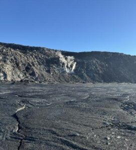
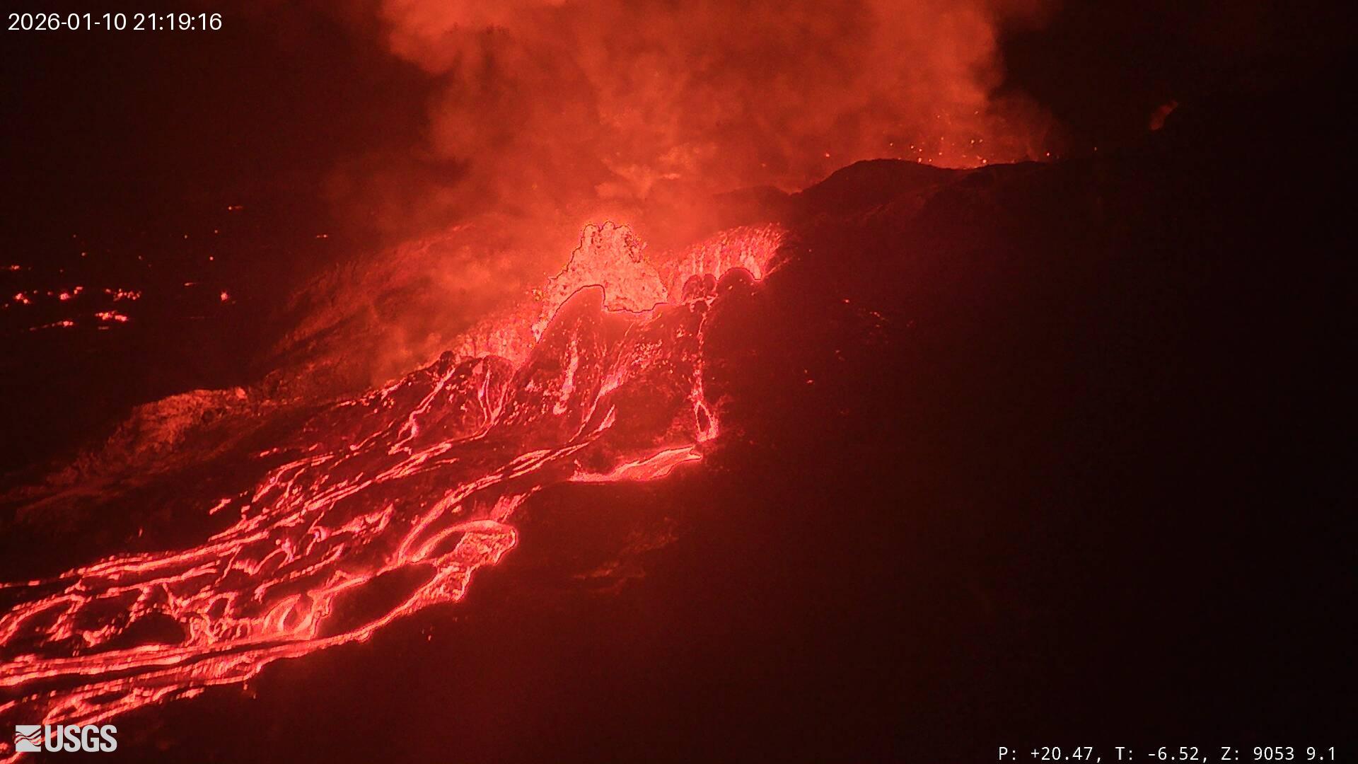
Hawaii , Kilauea :
HAWAIIAN VOLCANO OBSERVATORY DAILY UPDATE , U.S. Geological Survey
Saturday, January 10, 2026, 9:40 AM HST (Saturday, January 10, 2026, 19:40 UTC)
19°25’16 » N 155°17’13 » W,
Summit Elevation 4091 ft (1247 m)
Current Volcano Alert Level: WATCH
Current Aviation Color Code: ORANGE
Activity Summary:
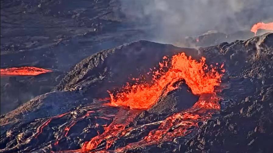
Lava overflowed intermittently from the north and south vents in Halemaʻumaʻu overnight with only short breaks between flows. Dome fountaining and spattering have increased this morning along with tremor. Kīlauea summit region showed some overnight inflation on tiltmeter UWD but changed to a slight deflation with the onset of dual overflows this morning. Forecasting models suggest the window for episode 40 sustained lava fountaining is between January 10 and 14 but current activity suggests that episode 40 fountaining could begin anytime. Kīlauea’s East Rift Zone and Southwest Rift Zone remain quiet.
A VAN/VONA notice will be issued at the onset of episode 40 sustained lava fountaining.
Summit Observations:
The four lava overflows that began on the afternoon of January 8 from the south vent transitioned to nearly continuous overflows from the north vent most of last night and this morning. At 5:12 a.m. HST this morning overflows began again from the south vent fed by 10 foot (3 meter) dome fountains while north vent flows diminished but spattering continued. Both vents began overflowing together around 7:00 a.m. with intermittent pauses of 5-10 minutes. Activity increased just before 7:30 a.m. and fountains roughly doubled in size to 20 feet (6 meters) and have remained constant since then. Seismic tremor increased around 7:00 a.m. when both fountains became active and again at 7:30 a.m. HST as fountaining intensity increased. Fountain heights and tremor have remained relatively constant since then.
Since the end of episode 39, the Uēkahuna tiltmeter (UWD) has recorded 23 microradians of re-inflation beneath Kīlauea summit, an increase of 1.3 microradians in the past 24 hours. Slight deflation began around 5:00 a.m. when the south vent overflowed. The deflation rate on UWD increased slightly at 7:00 a.m. HST when both vents became active and continues to deflate at that rate. The SMC tiltmeter mirrors the UWD tiltmeter, but SDH shows continued inflation, possibly influenced by the deeper south caldera magma chamber.
Volcanic gas emission rates have dropped significantly since the end of episode 39 but probably remain in the range of 1,000 to 5,000 tonnes of sulfur dioxide (SO2) per day, as typically observed during previous eruptive pauses. Winds are light out of the north (less than 10 mph or 2 m/sec) and are forecast to become more easterly as the morning progresses. The plume is moving to the south-southwest of Halema’uma’u.
Rift Zone Observations:
Rates of seismicity and ground deformation remain very low in the East Rift Zone and Southwest Rift Zone. SO2 emissions from the East Rift Zone remain below the detection limit.
Analysis:
The rapid rebound of inflationary tilt and presence of low-level volcanic tremor after episode 39 indicate that another lava fountaining episode is likely to occur. Nearly continuous overflows of the north vent overnight coupled with overflows from both vents this morning suggest the onset of episode 40 is close. The increased intensity of fountaining not associated with drainbacks, indicates the magma is becoming progressively more gas rich. Forecast models suggest the window for onset of episode 40 fountaining is between January 10 and 14, but the activity suggests it could start anytime and is highly likely to begin no later than the next 12–24 at the most.
Source et photo : HVO.
Philippines , Mayon :
MAYON VOLCANO ADVISORY , 11 January 2026 , 12:45 PM
This is a notice of increased seismic energy release in Mayon Volcano.
Starting today, 11 January 2026, a pronounced increase in real-time seismic energy release (RSAM) was recorded by six (6) of sixteen (16) stations of the Mayon Volcano Network. This increase was induced by background tremor while no other volcanic earthquakes have been detected, which may be due to prevailing fully open vent conditions as the volcano effusively erupts. There have been no corresponding increases in swelling or ground deformation, although Mayon has been exhibiting non-uniform inflation or swelling dominantly on its eastern sector since June 2024 based on continuous GPS, electronic tilt and EDM ground deformation data. Sulfur dioxide SO2 emissions have remained near background levels, averaging 777 tonnes/day yesterday. As of advisory time RSAM has begun decreasing, but this episode could forewarn of new intrusions into the Mayon edifice that could lead to further eruptive activity.
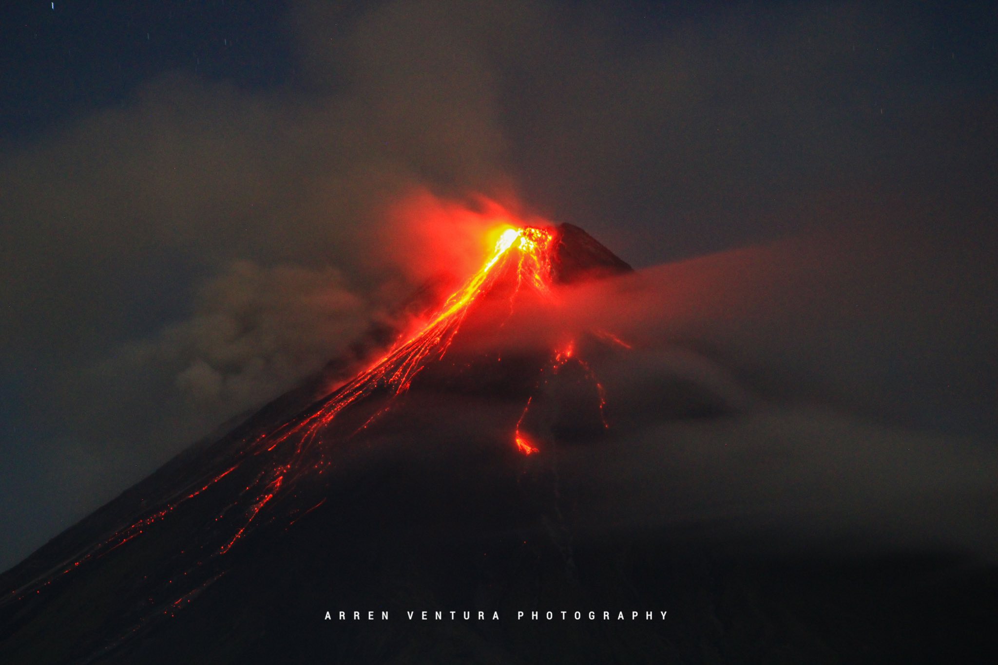
DOST-PHIVOLCS would like to remind the public that Mayon Volcano is at Alert Level 3 as the eruption of a summit lava dome is occurring and continues to generate new lava flows and collapse-fed rockfall and pyroclastic density currents (PDCs) or uson onto the southern and eastern upper slopes. The public should refrain from entering the 6-kilometer radius Permanent Danger Zone (PDZ) due to the danger of PDCs, lava flows, rockfalls and other volcanic hazards. Residents within the 8-kilometer radius must also be prepared for evacuation in case monitoring parameters suddenly escalate and the volcano status is stepped up to Alert Level 4. Increased vigilance against lahars and sediment-laden streamflows along channels draining the edifice is also advised in the event that intense rains occur over the summit area. Civil aviation authorities must also advise pilots to avoid flying close to the volcano’s summit as ash from any sudden eruption can be hazardous to aircraft.
DOST-PHIVOLCS maintains close monitoring of Mayon Volcano and any new development will be communicated to all concerned stakeholders.
Source : DOST-PHIVOLCS
Photo : Arren Ventura photography / FB.
Chile / Argentina , Laguna del Maule :
During the evaluated period, volcano-tectonic (VT) seismic activity, associated with rock fracturing within the volcano, showed a slight increase in the number of recorded events compared to the previous period. However, their energy levels remained similar. The highest-energy VT event recorded had a local magnitude (ML) of 3.0 and was located 1.0 km south-southeast (SSE) of the lake center, at a depth of 7.1 km. Seismic activity associated with fluid movement within the volcano, represented by long-period (LP) events, recorded a similar number of events to the previous period, as well as similar energy release values.

The most energetic event, measured by its reduced displacement (Dr), recorded a value of 2.0 cm². The occurrence of three hybrid seismic events, linked to both rock fracturing and fluid displacement, is noteworthy. The most energetic of these had a magnitude of 1.3 and a depth of 17.0 cm², located 8.0 km west-southwest (WSW) of the lagoon center, at a depth of 5.7 km.
Data from GNSS stations installed near the volcanic complex showed values similar to those of the previous period, for both vertical and horizontal deformation rates. Both rates remain high relative to the reference level. The cumulative vertical deformation in 2025 was approximately 25 cm. Images from surveillance cameras installed near the volcanic complex revealed no associated surface activity. Furthermore, the processing of satellite images did not detect any thermal anomalies related to the volcanic complex.
Source et photo : Segemar.
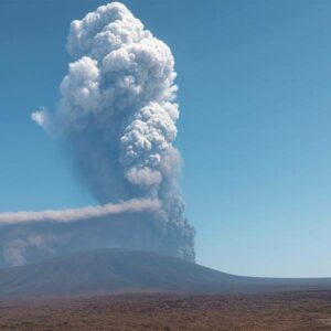
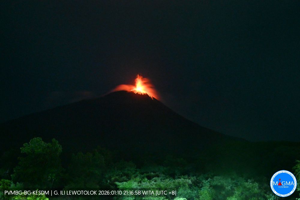
Indonesia , Ili Lewotolok :
An eruption of Mount Ili Lewotolok occurred on Sunday, January 11, 2026, at 12:11 PM WITA. The observed ash column rose approximately 500 meters above the summit (at an altitude of about 1,923 meters). This gray-black column was highly intense and drifted eastward. The eruption was recorded by a seismograph, with a maximum amplitude of 32.7 mm and a duration of 96 seconds.
Seismic Observations
183 eruption earthquakes with amplitudes between 24.1 and 33 mm and durations of 39 to 44 seconds.
422 emissions earthquakes with amplitudes between 1.6 and 18.8 mm and durations of 35 to 40 seconds.
73 non-harmonic tremors with amplitudes between 4.7 and 24.1 mm and durations of 128 to 461 seconds.
2 shallow volcanic earthquakes with amplitudes between 8.4 and 13.8 mm and durations of 7 to 8.5 seconds.
1 local tectonic earthquake with an amplitude of 37.9 mm and duration of 3 seconds.
1 distant tectonic earthquake with an amplitude of 11.4 mm and duration of 10 seconds.
Recommendations
1. Residents living around Mount Ili Lewotolok, as well as visitors, climbers, and tourists, are advised to refrain from any activity or access within a 2 km radius of the Mount Ili Lewotolok activity center and within a 2.5 km radius of the South-Southeast and West sectors.
2. Be vigilant for the risk of lava avalanches and pyroclastic flows in the South, Southeast, West, and Northeast sectors of Mount Ili Lewotolok. The public is advised not to panic if rumbling or detonating sounds are heard from the Mount Ili Lewotolok crater, as these noises are characteristic of volcanic activity during an eruptive phase.
Source et photo : Magma Indonésie .
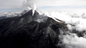
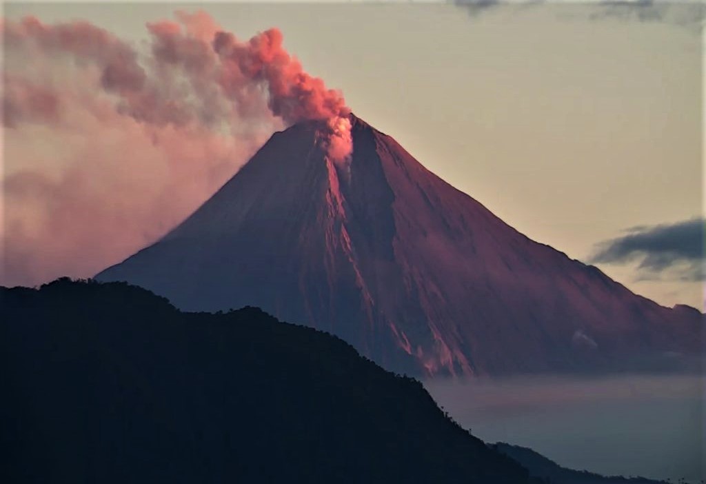
Ecuador , Sangay :
DAILY REPORT ON THE STATE OF SANGAY VOLCANO, Saturday, January 10, 2026.
Geophysical Information Institute – EPN.
Surface Activity Level: Moderate, Surface Trend: No Change
Internal Activity Level: Moderate, Internal Trend: Descending.
Seismicity: From January 9, 2026, 11:00 AM to January 10, 2026, 11:00 AM:
Due to technical problems at the monitoring stations, no seismic events were recorded.
Precipitation/Lahars:
No precipitation was recorded in the volcano area. **Heavy rainfall could remobilize accumulated material, generating mudflows and debris flows that would cascade down the volcano’s flanks and flow into nearby rivers.**
Emission/Ash Column:
Several gas and ash emissions were recorded by surveillance cameras, reaching a height of 400 meters above the crater rim, drifting west-southwest and southwest. The Washington VAAC agency has not issued any reports concerning this volcano.
Other Monitoring Parameters: The FIRMS satellite system recorded a thermal anomaly, and the MIROVA-VIIRS satellite system also recorded one.
Observation:
From yesterday afternoon until the time of writing, the volcano has remained mostly cloudy. However, incandescence was observed at the crater rim overnight.
Alert Level: Yellow
Source : IGEPN
Photo : Webcam