January 6 , 2025.
Italy / Sicily , Etna :
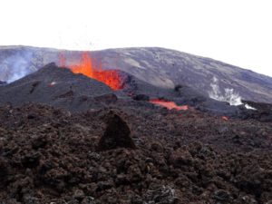
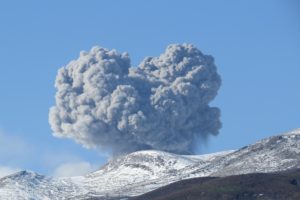
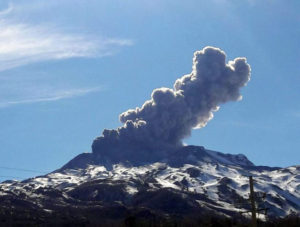
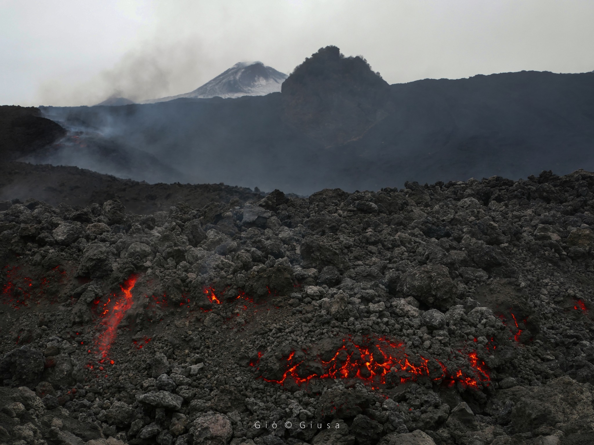
Etna Activity Update, January 5, 2026, 11:25 (10:25 UTC).
The National Institute of Geophysics and Volcanology (INGV), Etna Observatory, reports that surveillance cameras and field surveys conducted by INGV staff show that the Valle del Bove lava field remains active. The lava flow, whose front was at an altitude of 1,400 meters yesterday, has also reached an altitude of 1,360 meters, joining the flow from previous days, which has now stopped and is cooling. Furthermore, further upstream, at approximately 1,500 meters, a new active lava flow has been observed, also superimposed on the previous ones. Due to adverse weather conditions, observation of the volcano’s summit area was not possible. From a seismic perspective, the average amplitude of the volcanic tremor showed a slow and gradual increase starting around 00:00 UTC on January 5, reaching a maximum value around 05:20 UTC; subsequently, a sudden decrease in amplitude was observed, and it is currently at low values. The center of gravity of the volcanic tremor sources is located in an area northwest of the Southeast Crater, at an altitude of approximately 1500 to 2000 m above sea level.
It should be noted that at 05:19 UTC, a clearly visible seismic signal was recorded, particularly at the summit stations, for approximately 2 minutes. This signal cannot be associated with fracturing or explosive activity, but is likely attributable to a landslide.
Regarding infrasound signals, it was not possible to perform a reliable assessment, either in terms of frequency of occurrence or source location, due to significant noise caused by adverse weather conditions. The DRUV inclinometer, starting at approximately 19:00 UTC on January 4, indicates a trend reversal, with the onset of a slight compression phase characterized by a few oscillations (approximately 15 nano-deformations were accumulated at that time). The same variation (less than 0.5 microradians) is visible on the ECP summit inclinometer. The GNSS (HF) network shows no significant variation.
Further updates will be communicated soon.
Source : INGV.
Photo : Gio Giusa .
Alaska , Shishaldin :
54°45’19 » N 163°58’16 » W,
Summit Elevation 9373 ft (2857 m)
Current Volcano Alert Level: ADVISORY
Current Aviation Color Code: YELLOW
Signs of volcanic unrest at Shishaldin Volcano continued to be observed this week. Web camera images, when clear, showed a gas plume rising from the summit crater. Clear satellite views on Sunday showed weakly elevated surface temperatures and steaming from the summit crater. There has been ongoing low-level seismic activity, with frequent small earthquakes occurring each day. Infrasound signals, likely caused by gas bubbles bursting through magma deep within the volcanic vent, were also detected throughout the week when the conditions were not too windy. There is no indication, though, that lava is present at or near the surface.
Shishaldin Volcano is monitored by local seismic and infrasound sensors, web cameras, and a telemetered geodetic network. In addition to the local monitoring network, AVO uses nearby geophysical networks, regional infrasound and lighting data, and satellite data to monitor the volcano.
Shishaldin Volcano, located near the center of Unimak Island in the eastern Aleutian Islands, is a conical stratovolcano with a base diameter of approximately 10 miles (16 km). It is one of the most active volcanoes in the Aleutian volcanic arc, with at least 54 episodes of unrest including over 28 confirmed eruptions since 1824. Most eruptions are relatively small, although activity during July – November 2023 generated ash columns that reached between 30,000 ft (9 km) and 42,000 ft (13 km) above sea level.
Source : AVO
Photo : Loewen, Matt .
Philippines , Mayon :
MAYON VOLCANO BULLETIN , 6 January 2026 , 01:20 PM
This serves as a notice of alert level raise from Alert Level 2 (increasing unrest) to Alert Level 3 (increased tendency towards a hazardous eruption) of Mayon Volcano.
Since the Alert Level status was raised from Alert Level 1 to Alert Level 2 on 1 January 2026, repeated collapse of the unstable summit dome of Mayon Volcano has generated an increasing number and volume of rockfall events. A total of 346 rockfall events and 4 volcanic earthquakes were recorded since 1 January 2026, compared to 599 rockfall events from November to December 2025. These events had durations of one (1) to five (5) minutes and transported lava debris within a kilometer range of the southern upper slopes. The volume of discrete rockfall, with observed incandescence at nighttime, increased yesterday, signaling an increase in the rate of dome growth and the onset of extrusion of new lava at the crater. Pyroclastic density currents or PDCs on the Bonga (southeast) Gully began generating at 12:26 PM today from the collapse of newly extruded lava. The PDCs lasted at least three minutes based on the seismic record and emplaced within two kilometers of the summit crater. In contrast, SO2 emission remains at baseline or background levels. Short-term ground deformation data from continuous GPS, electronic tilt, and EDM monitoring indicate persistent inflation of the eastern and southeastern slopes since June 2024. The overall monitoring parameters indicate that very slow extrusion of shallow degassed magma is ongoing and is incrementally increasing in rate; i.e., effusive magmatic eruption is taking place.
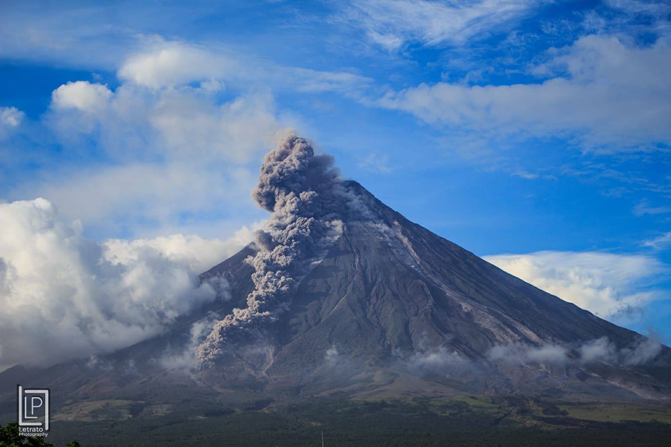
In view thereof, DOST-PHIVOLCS is now raising the alert status of Mayon Volcano from Alert Level 2 to Alert Level 3. This means that Mayon is exhibiting magmatic eruption of a summit lava dome, with increased chances of lava flows and hazardous PDCs or uson affecting the upper to middle slopes of the volcano and of potential explosive activity within days or weeks. It is therefore recommended that the 6-km radius Permanent Danger Zone (PDZ) be evacuated due to the danger of PDCs, lava flows, rockfalls and other volcanic hazards. Increased vigilance against pyroclastic density currents, lahars and sediment-laden streamflows along channels draining the edifice is also advised. Civil aviation authorities must also advise pilots to avoid flying close to the volcano’s summit as ash from any sudden eruption can be hazardous to aircraft. Based on the current prevailing wind pattern, ash fall events may most likely occur on the south side of the volcano. DOST-PHIVOLCS maintains close monitoring of Mayon Volcano and any new development will be communicated to all concerned stakeholders.
Source : DOST-PHIVOLCS.
Photo : Letrato.
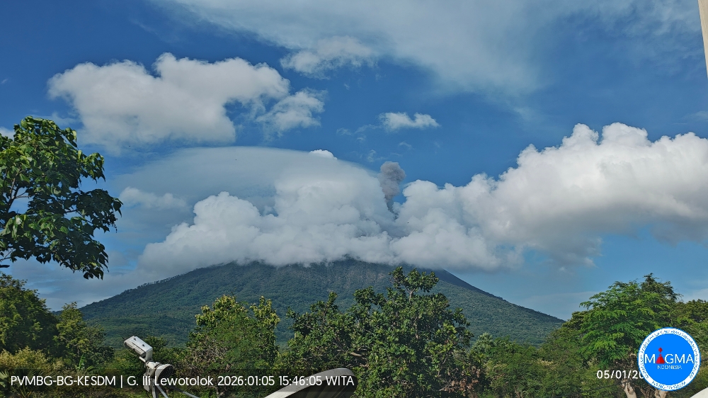
Indonesia , Ili Lewotolok :
An eruption of Mount Ili Lewotolok occurred on Monday, January 5, 2026, at 3:43 PM WITA. The observed ash column rose approximately 500 meters above the summit (at an altitude of about 1,923 meters). The thick, white to gray ash column drifted eastward. This eruption was recorded by a seismograph, with a maximum amplitude of 28.8 mm and a duration of 45 seconds.
Seismic Observations
62 eruption earthquakes with amplitudes ranging from 14.8 to 34.2 mm and durations of 40 to 90 seconds.
473 emissions earthquakes with amplitudes ranging from 1.8 to 21 mm and durations of 21 to 43 seconds.
One harmonic tremor with an amplitude of 1.6 mm and a duration of 230 seconds.
19 non-harmonic tremors with amplitudes ranging from 2.3 to 28.2 mm and durations of 118 to 512 seconds.
Two deep volcanic earthquakes with amplitudes ranging from 2.3 to 3.9 mm and durations of 17 to 19 seconds.
A local tectonic earthquake with an amplitude of 3.5 mm and a duration of 23 seconds.
A distant tectonic earthquake with a magnitude of 5.4 mm and a duration of 64 seconds was recorded.
Recommendations
1. Residents living around Mount Ili Lewotolok, as well as visitors, climbers, and tourists, are advised to refrain from all activities within a 2 km radius of the Mount Ili Lewotolok activity center and within a 2.5 km radius of the south-southeast and west sectors of the mountain.
2. Be vigilant for the risk of lava avalanches and pyroclastic flows in the south, southeast, west, and northeast sectors of Mount Ili Lewotolok. The public is advised not to panic if rumbling or detonating sounds are heard from the crater of Mount Ili Lewotolok, as these noises are characteristic of volcanic activity during an eruptive phase.
Source et photo : Magma Indonésie .
Guatemala , Santiaguito :
Weather conditions: Clear skies
Wind: Northeast
Rainfall: 0 mm
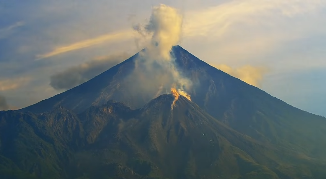
Activity
Activity is being recorded at the Caliente dome of the Santa María-Santiaguito volcanic complex. White plumes are rising up to 600 m above the crater. Between one and two weak to moderate explosions per hour are being observed, generating columns of gas and ash that reach 3,500 m. These columns are drifting west and southwest, causing ashfall on surrounding farms and villages. During the night and early morning, incandescence is being observed in the crater, along with collapses of incandescent volcanic material on the flanks. Due to this intense activity, the formation of long-distance pyroclastic flows in various directions cannot be ruled out. Therefore, it is recommended to monitor Special Bulletin BESAN-063-2025.
Source : Insivumeh .
Photo : AFAR TV ( capture d’écran)