January 5 , 2026.
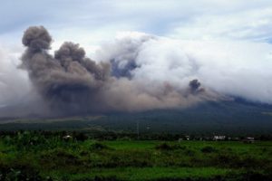
Italy / Sicily , Etna :
Etna Activity Update, January 4, 2026, 12:44 PM (11:44 UTC).
The National Institute of Geophysics and Volcanology (INGV), Etna Observatory, reports that surveillance cameras and field surveys conducted by INGV personnel indicate that the Valle del Bove lava field is still being fed. Specifically, the lava flow, whose front reached an altitude of 1,360 m yesterday, is stationary and cooling, while the overlying lava flow, which reached an altitude of 1,600 m yesterday, is active and its front is currently at an altitude of approximately 1,400 m. Simultaneously, Strombolian activity continues at varying intensity at the Voragine crater, with intermittent and weak ash emissions that disperse rapidly in the summit area.
From a seismic perspective, the average amplitude of the volcanic tremor, although exhibiting some oscillations, is currently within the average range. The center of gravity of the volcanic tremor sources appears to be located near the Voragine crater, at an altitude of approximately 2,800 to 3,000 meters.
Regarding infrasound signals, it was not possible to conduct a reliable assessment of either their frequency of occurrence or the location of the sources due to the high noise level caused by adverse weather conditions.
The tilt and GNSS networks show no significant changes.
Further information will be provided shortly.
Source : INGV.
Photo : Giuseppe Distefano/ Etna Walk / FB.
Indonesia , Egon :
Increased Seismic Activity at Mount Egon, Sikka Regency, East Nusa Tenggara Province. January 5, 2026
Instrumental monitoring conducted from December 2025 to January 4, 2026, at Mount Egon in Sikka Regency, East Nusa Tenggara Province, indicates a significant increase in seismicity.
Mount Egon (1,703 m above sea level) is a stratovolcano with a summit crater. Mount Egon is located at 8°40′ south latitude and 122°27′ east longitude. Its last eruption, with a Volcanic Explosivity Index (VEI) of 2, occurred in April 2008.

Mount Egon’s activity increased significantly in December 2025 compared to November 2025. In December 2025, 50 deep volcanic earthquakes (VA), 2 shallow volcanic earthquakes (VB), and 20 local tectonic earthquakes were recorded. In November 2025, 5 deep volcanic earthquakes (VA), 7 shallow volcanic earthquakes, and 16 local tectonic earthquakes were recorded. On January 4, 2026, 8 deep volcanic earthquakes and 1 local tectonic earthquake occurred. Mount Egon was obscured by fog and crater smoke at that time.
Mount Egon’s current activity level is I (normal). Due to this level of activity, the public and visitors/tourists are advised not to approach, descend into, or spend the night at the crater to avoid any risk of a phreatic eruption.
Given the increased seismicity of Mount Egon, the public is advised to follow the recommendations of the Geological Survey, issued by the Center for Volcanology and Geological Hazard Mitigation, and not to be influenced by erroneous or irresponsible information regarding its activity. It is also recommended to follow the directives of the Geological Survey, which continues to coordinate with the National Disaster Management Agency (BNPB), the Meteorology, Climatology and Geological Hazard Mitigation Agency (BMKG), relevant ministries and agencies, local authorities, and other relevant organizations.
Source : PVMBG.
Photo : Aquatravel
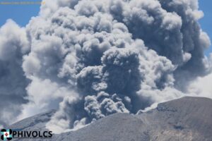
Colombia , Puracé – Los Coconucos volcanic chain :
Popayán, January 4, 2026, 9:00 AM
Regarding the monitoring of activity in the Los Coconucos volcanic chain, the Colombian Geological Survey (SGC), an agency under the Ministry of Mines and Energy, reports the following:
Since yesterday’s extraordinary bulletin, earthquakes related to fluid movements within the volcanic edifice continue to be recorded. These are long-period (LP) and tremor (TR) earthquakes. These earthquakes are located beneath the crater of the Puracé volcano, at depths of less than 1 km, and are associated with the release of volcanic gases into the atmosphere. Among the seismic signals detected, eleven (11) were related to ash emissions, for which alerts have been issued to the Civil Aviation Authority. The ash plumes dispersed mainly to the Northwest and West, following the wind direction, reaching more than 800 meters above the summit of the volcano.
Ashfall and gas odors have been reported in the Cristales region, northwest of the Purace volcano.
Sulfur dioxide (SO₂) emissions into the atmosphere continue, and high temperatures in the crater area remain similar to those recorded in recent days, which are linked to gas emissions from within the volcano. Meanwhile, degassing continues through the fissures of the Curiquinga and Piocollo volcanoes, although no ash emissions have been detected.
While the orange alert remains in place, temporary fluctuations in volcanic activity are possible, meaning that activity may sometimes decrease compared to previous days or weeks. However, this does not necessarily mean that the volcano has returned to a stable level of activity. A reasonable amount of time is needed to assess all monitored parameters and determine any trends indicating such a return before the alert level returns to yellow (greater stability).
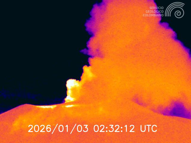
A recording from the Mina camera, located 2.2 km north of the Puracé volcano, shows an ash emission recorded on January 3 at 2:32 a.m. (local time).
Given the above, the Colombian Geological Survey (SGC) recommends staying away from the craters of the Puracé, Piocollo, and Curiquinga volcanoes, as well as their surrounding areas. We suggest you closely monitor the situation through special bulletins and information published on our official channels, and follow the instructions of local and departmental authorities and the National Unit for Disaster Risk Management (UNGRD).
The volcanic activity level remains at ORANGE alert: Volcano exhibiting significant variations in monitored parameters.
Source et photo : SGC.
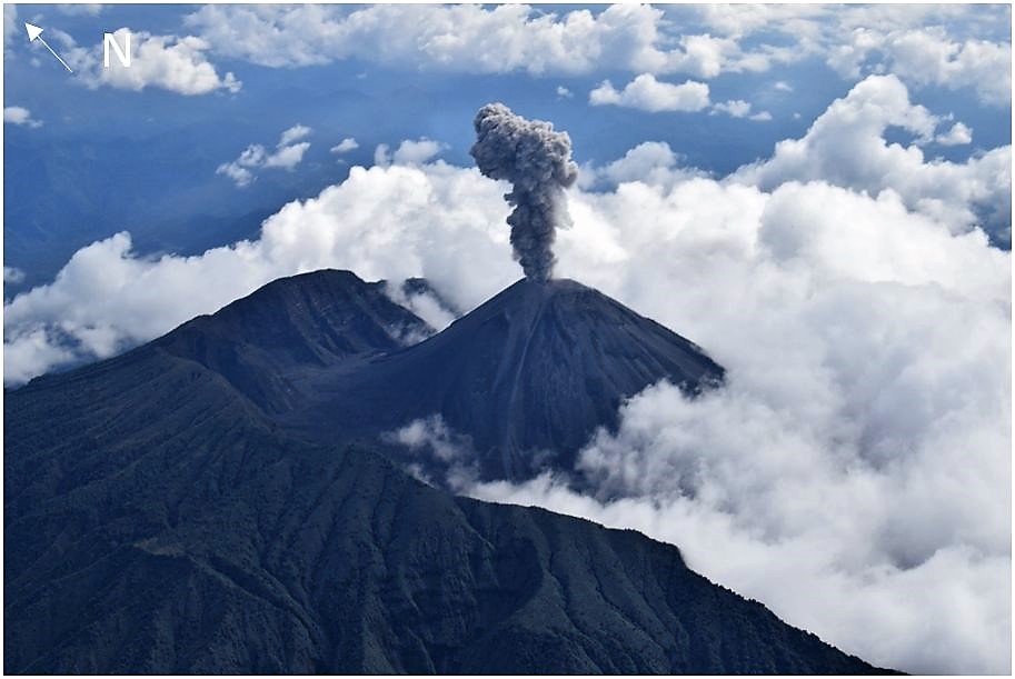
Ecuador , El Reventador :
REVENTADOR VOLCANO DAILY STATE REPORT, Sunday, January 4, 2026.
Information Geophysical Institute – EPN.
Surface Activity Level: High, Surface Trend: No Change
Internal Activity Level: Moderate, Internal Trend: No Change
From January 3, 2026, 11:00 AM to January 4, 2026, 11:00 AM:
Seismicity:
Due to technical issues at the seismic monitoring stations, statistics for seismic events associated with the volcano are not available.
Rainfall/Lahars:
No precipitation has been recorded in the volcano’s vicinity. **Heavy rainfall could remobilize accumulated material, generating mudflows and debris flows that would cascade down the volcano’s flanks and flow into nearby rivers.**
Ash Emissions:
Due to weather conditions, it was not possible to observe gas or ash emissions using surveillance cameras. However, satellite imagery detected several ash plumes reaching an altitude of 1,000 meters above the crater, drifting west-northwest and northwest. In this regard, the VAAC agency in Washington issued four reports concerning ash plumes with altitudes between 700 and 1,600 meters, also drifting west-northwest and northwest.
Other monitoring parameters:
The MIROVA-MODIS satellite system recorded two thermal anomalies: MIROVA-VIIRS 6 and FIRMS 12.
Note: From yesterday afternoon until the time of writing this report, the area remained cloudy.
Alert level – SGR: Orange
Source et photo : IGEPN.
Island of Martinique , Mount Pelée. :
Weekly Report, Paris Institute of Earth Physics / Martinique Volcanological and Seismological Observatory
Saint-Pierre, January 2, 2026, 3:30 p.m. local time (GMT-4)
Volcanic activity increased this week with 119 volcanic earthquakes observed.
Between December 26, 2025, 4:00 p.m. UTC and January 2, 2026, 4:00 p.m. UTC, the Martinique Volcanological and Seismological Observatory recorded:
• 115 shallow volcano-tectonic earthquakes. Among them, 4 had a magnitude (duration magnitude Md or local magnitude Mlv) greater than 0.5. The largest had a magnitude Mlv of 1.1. The others were of lower energy. These earthquakes originated from the well-known seismically active zones of Mount Pelée, located between 1.0 and 1.4 km below the volcano’s summit. Shallow volcano-tectonic seismicity is associated with microfracturing within the volcanic edifice, linked to the overall reactivation of the volcano observed since 2019.
• Four shallow hybrid earthquakes were recorded. Two of these were located approximately 1.5 km below the volcano. The largest had a magnitude of Mlv = 0.65. Hybrid seismic signals are enriched in low frequencies and are associated with the circulation of fluids (gases, hydrothermal fluids) within the volcanic edifice.
No earthquakes were felt by the population.

The previous week, the OVSM (Mountain Seismological Observatory) recorded 54 volcanic earthquakes. As of January 2, 2026, and over the past four weeks, the OVSM has observed a total of 252 volcanic earthquakes, an average of 63 earthquakes per week.
During phases of volcanic reactivation of volcanoes similar to Mount Pelée, seismic activity of varying intensity and frequency is common. The probability of an eruptive activity in the short term remains low. However, considering all the observations collected since the end of 2018 and their nature, and based on recent observations from the OVSM-IPGP (Paris Institute of Earth Physics), we cannot rule out a change in the situation in the medium term (weeks, months).
For more details on observations and interpretations of volcanic activity over the longer term, please refer to the OVSM’s monthly bulletins.
The volcanic alert level, in accordance with the provisions made by the authorities, is currently YELLOW: vigilance.
Source : Direction de l’OVSM-IPGP.
Photo : Rci fm