January 4 , 2026.
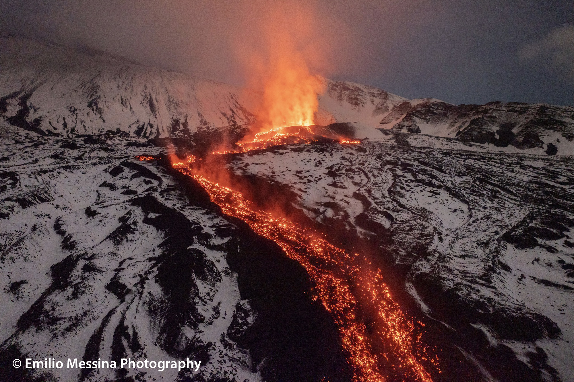
Italy / Sicily , Etna :
Etna Activity Update, January 3, 2026, 1:52 PM (12:52 UTC).
The National Institute of Geophysics and Volcanology (INGV), Etna Observatory, reports that, according to surveillance camera images and field surveys conducted by INGV staff using drones, the Valle del Bove lava field is still being fed and that the most advanced front has slowly reached an altitude of approximately 1,360 m. More specifically, the drone overflight revealed that the most active area of the lava field is located upstream of Rocca Musarra, between 1,800 and 1,700 m above sea level, where a lava flow, superimposed on those of previous days (front at 1,360 m), is feeding several smaller lava flows.
Currently, the front of the superimposed lava flow is located at an altitude of approximately 1,600 m above sea level. Surveillance camera images also show that Strombolian activity continues at varying intensities at the Voragine crater, with light ash emissions that disperse rapidly in the summit area.
From a seismic perspective, the average amplitude of the volcanic tremor showed oscillations starting around 11:00 AM on January 2nd, remaining within the average range and occasionally reaching high values. The center of gravity of the volcanic tremor sources appears to be located in an area near the Voragine crater, at an altitude of approximately 2,800 to 3,000 meters above sea level.
Regarding infrasound signals, a reliable assessment of both frequency and source location was not possible due to unfavorable weather conditions. Ground deformation monitoring networks showed no significant variations.
Further updates will be provided shortly.
Source : INGV.
Photo : Emilio Messina Photography.
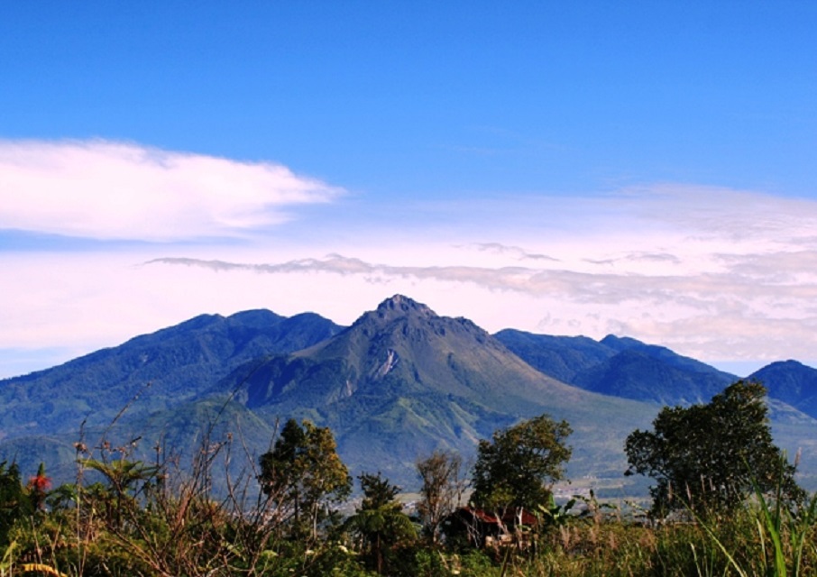
Indonesia , Bur Ni Telong :
The activity level of Mount Bur Ni Telong, in Aceh Province, was raised from Level II (WASPADA) to Level III (SIAGA) on December 30, 2025.
Bur Ni Telong is a stratovolcano with a summit reaching 2,624 meters above sea level, located at 96° 49’ 16” East longitude and 4° 46’ 10” North latitude. It is administratively situated in the Bener Meriah Regency, Aceh Province.
Between 8:43 PM and 10:45 PM West Indonesian Time (WIB), seven earthquakes were recorded approximately 5 km southwest of the summit of Mount Bur Ni Telong. These earthquakes were followed by an increase in seismic activity, both deep and shallow. At 22:45 WIB, seven shallow volcanic earthquakes (VB), fourteen deep volcanic earthquakes (VA), one local tectonic earthquake, and one distant tectonic earthquake were recorded. At 21:44 WIB, the volcano was clearly visible, and no crater smoke was observed.
Seismic activity at Mount Bur Ni Telong has been increasing since July 2025, and by December 30, 2025, approximately ten deep volcanic earthquakes (VA) had been recorded. This increase intensified, and seismic activity became less intense in November and December 2025. The occurrence of aftershocks following local tectonic earthquakes indicates magmatic activity, possibly triggered by tectonic earthquakes around Mount Bur Ni Telong. Potential hazards include eruptions triggered by these earthquakes, or phreatic eruptions without a significant increase in seismic activity. Another potential hazard lies in the emissions of volcanic gases around solfataras and fumaroles, which can be dangerous if inhaled gas concentrations exceed safety thresholds.
Based on visual and instrumental observations, the activity level of Mount Bur Ni Telong has changed from level II (WASPADA) to level III (SIAGA) as of December 30, 2025 at 10:45 PM (Jakarta time).
Source : PVMBG.
Photo : rafina2802 /wordpress.com
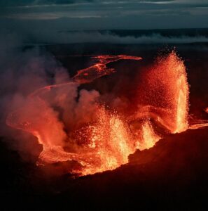
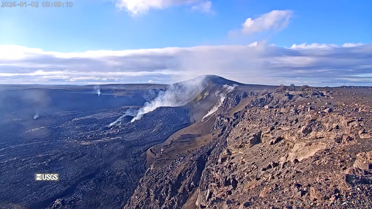
Hawaii , Kilauea :
HAWAIIAN VOLCANO OBSERVATORY DAILY UPDATE , U.S. Geological Survey.
Saturday, January 3, 2026, 8:36 AM HST (Saturday, January 3, 2026, 18:36 UTC)
19°25’16 » N 155°17’13 » W,
Summit Elevation 4091 ft (1247 m)
Current Volcano Alert Level: WATCH
Current Aviation Color Code: ORANGE
Activity Summary:
The ongoing Halemaʻumaʻu eruption is paused. Overnight webcam views showed persistent glow from the south vent and several instances of brief glow from the north vent. Summit inflation is underway and forecasting models suggest the window for lava fountaining episode 40 is between January 8 and 14. Kīlauea’s East Rift Zone and Southwest Rift Zone remain quiet.
Summit Observations:
Overnight webcam views showed persistent glow from the Halemaʻumaʻu south vent and several instances of brief glow from the north vent. Low-frequency tremor at rates of one to three events every 5 to 10 minutes continue to be observed in summit seismic and infrasound data.
Since the end of episode 39, the Uēkahuna tiltmeter (UWD) has recorded 17.5 microradians of re-inflation beneath Kīlauea summit.
Volcanic gas emission rates have dropped significantly since the end of episode 39 but probably remain in the range of 1,000 to 5,000 tonnes of sulfur dioxide (SO2) per day, as typically observed during previous eruptive pauses.
Rift Zone Observations:
Rates of seismicity and ground deformation remain very low in the East Rift Zone and Southwest Rift Zone. SO2 emissions from the East Rift Zone remain below the detection limit.
Analysis:
The rapid rebound of inflationary tilt and presence of low-level volcanic tremor after episode 39 indicate that another lava fountaining episode is likely to occur. Forecasting models suggest the window for episode 40 is between January 8 and 14. Current inflation rates are significantly slower than those leading up to episode 39, and the forecast window may change as more data are incorporated into the models.
Source et photo : USGS.
La Réunion Island , Piton de la Fournaise :
Monthly Bulletin, Paris Institute of Earth Physics / Piton de la Fournaise Volcanological Observatory: December 2025
Observations
In December 2025, the OVPF-IPGP recorded the following at the Piton de la Fournaise massif:
• 1,564 shallow volcano-tectonic earthquakes (0 to 2.5 km above sea level) beneath the summit craters;
• 166 deep earthquakes (below sea level);
• 40 long-period earthquakes;
• 208 rockfalls.
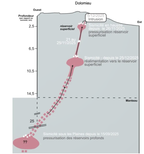
Following the resumption of seismic activity beneath the summit of Piton de la Fournaise at the end of November 2025, significant seismicity continued in December 2025 beneath the Dolomieu crater.
This seismic activity culminated on December 5, 2025, with a seismic crisis during which 227 shallow volcano-tectonic earthquakes were recorded between 6:25 PM and 7:30 PM UTC (10:25 PM and 11:30 PM local time). The majority of these earthquakes had magnitudes less than 1. Some were located and show a migration from an altitude of 300 m below the southeastern rim of the Dolomieu crater to an altitude of 800 m below the northeastern rim of the Dolomieu crater. These locations indicate a vertical migration of less than 500 m below the eastern rim of the Dolomieu crater. This seismic crisis corresponds to an injection of magma from the shallow reservoir (located around sea level below the Dolomieu crater) towards the surface, but which did not reach the surface (magmatic intrusion).

A small jerk signal (a very low-frequency transient observed in horizontal ground motion at the Rivière de l’Est seismological station, both in acceleration and inclination; Beauducel et al., 2025) was emitted (only 0.1 nm/s³), confirming that a magma intrusion had indeed occurred.
Following this intrusion, shallow seismicity continued at a fluctuating rate of 13 to 78 earthquakes per day between December 7 and 31, 2025. The location of these earthquakes is similar to that observed before the intrusion, namely along the entire annular fault—a large circular structure that encircles the summit—situated between the magma reservoir and the surface.
This seismicity indicates pressure variations within the shallow magma reservoir.
Starting on December 25, 2025, a marked increase in deep volcano-tectonic seismicity was recorded, peaking at 64 deep earthquakes on December 28. These earthquakes were located at a depth of approximately 9 km, beneath the northwest sector of the summit. The resumption of deep seismicity, although consisting mainly of low-magnitude events, suggests a reactivation that could indicate a renewed influx of deep magma into the volcano’s shallow magma supply system. Numerous (208) rockfalls were also recorded in the Dolomieu crater, at the Enclos Fouqué caldera walls, and at the Cassé de la Rivière de l’Est, as in previous months.
Summary
The reactivation of the shallow magma system of Piton de la Fournaise, observed since the end of November 2025, continued in December 2025. This pressurization triggered the seismic crisis of December 5, 2025, linked to an injection of magma from the shallow reservoir towards the surface, but which did not reach the surface (magmatic intrusion, Figure 1).
Following this intrusion, seismicity persisted, and inflation continued until December 14 before ceasing and then resuming at the end of December. The reactivation process of the magma supply system, with the pressurization of the shallow reservoir (located near sea level beneath the Dolomieu crater), therefore continued throughout December 2025, and likely with a new influx of deep magma observed from December 25, 2025, as evidenced by the resumption of deep seismicity.
Note that this pressurization process of the shallow reservoir can last from several days to several weeks – or even several months – before the rupture of the reservoir roof, thus giving rise to an injection of magma towards the surface and potentially to an eruption, but can also stop without giving rise – in the short term – to an eruption.
Source : OVPF.
Photos : Imaz Press , OVPF.
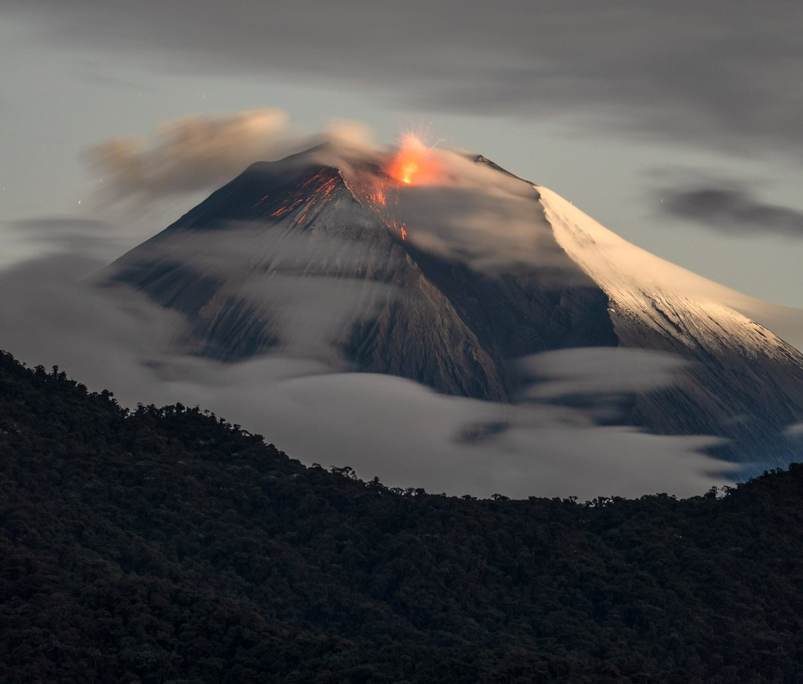
Ecuador , Sangay :
DAILY REPORT ON THE STATE OF SANGAY VOLCANO, Saturday, January 3, 2026.
Information Geophysical Institute – EPN.
Surface Activity Level: Moderate, Surface Trend: No Change
Internal Activity Level: Moderate, Internal Trend: Descending.
Seismicity: From January 2, 2026, 11:00 AM to January 3, 2026, 11:00 AM:
Due to technical problems at the monitoring stations, no seismic events could be recorded.
Rainfall/Lahars:
Rainfall occurred in the region but did not trigger any lahars. Heavy rainfall can remobilize accumulated material and generate debris-laden mudflows (lahars), which can cascade down the volcano’s flanks and flow into nearby waterways.
Emissions/Ash Columns:
Due to variable weather conditions, no emissions were observed by the monitoring camera system. However, satellite imagery detected an ash plume reaching an altitude of 800 meters above the crater, drifting southward. Regarding this activity, the Washington VAAC issued two emission reports, both reaching an altitude of 850 meters and drifting southward.
Other Monitoring Parameters:
The MIROVA-VIIRS and FIRMS satellite systems recorded two and four thermal anomalies, respectively.
Observation:
From yesterday afternoon until the writing of this report, the volcano remained mostly obscured by clouds. Despite this, it was possible to observe it briefly using cameras.
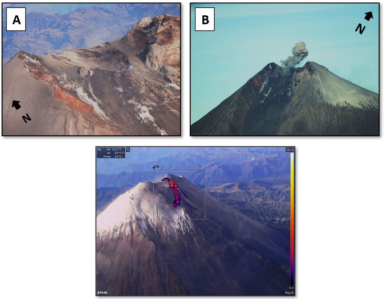
During an overflight, three main structures were identified at the summit of the volcano: the central crater (Fig. 3A), the Northwest crater (Fig. 3B), and a Northwest vent. Small explosions were observed at the Northwest crater, with plumes reaching a maximum height of approximately 500 m above the crater rim and drifting northward (Fig. 3B). The maximum apparent temperature (MAT) of this crater was estimated at 250 °C (Fig. 3C). A small, four-lobed lava flow (< 300 m long) was also observed, originating from the Northwest vent (located very close to the summit), with a MAT of 541 °C (Fig. 3C). Regarding the central crater, no surface activity was observed, as evidenced by its MAT, which is below 50 °C. Furthermore, continuous measurements of gaseous species were taken during the overflight using the MultiGAS portable instrument. However, no volcanic gas was detected because it was impossible to penetrate the plume due to the presence of ash.
Alert level: Yellow
Source : IGEPN
Photos : Robinsky , IGEPN.