December 20 , 2025.
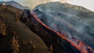
Alaska , Shishaldin :
Signs of volcanic unrest at Shishaldin Volcano continued to be observed this week. Webcam images, when clear, showed a gas plume rising from the summit crater. Additionally, satellite images captured the plume on several occasions. There has been ongoing low-level seismic activity, with frequent small earthquakes occurring each day. Infrasound signals, likely caused by gas bubbles bursting through magma deep within the volcanic vent, were also detected throughout the week, when the conditions were not too windy. There is no indication, though, that lava is present at or near the surface.
The strong winds early in the week caused resuspension of ash and other fine particles from the ground surface around Shishaldin Volcano and neighboring peaks on Unimak Island. This ash resuspension was not related to the current unrest.
Shishaldin Volcano is monitored by local seismic and infrasound sensors, web cameras, and a telemetered geodetic network. In addition to the local monitoring network, AVO uses nearby geophysical networks, regional infrasound and lighting data, and satellite data to monitor the volcano.
Source : AVO
Photo : Wetzel, Tarek ( 2016).
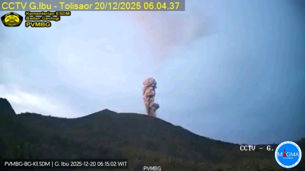
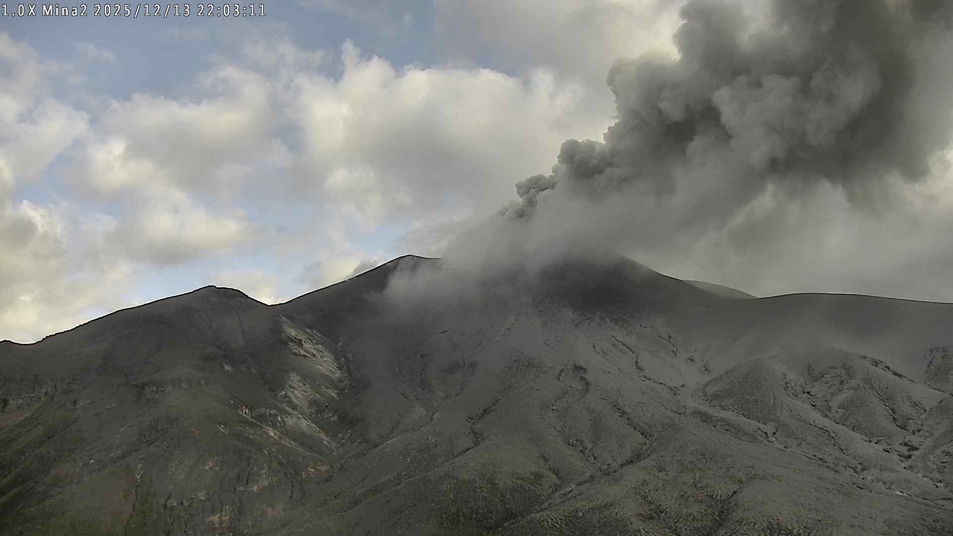
Indonesia , Ibu :
Mount Ibu erupted on Saturday, December 20, 2025, at 06:03 WIT, with an ash column approximately 500 m high above the summit (about 1,825 m above sea level). This ash column was white to gray in color, with moderate to strong intensity, and drifted northeast. The eruption was recorded by a seismograph, with a maximum amplitude of 28 mm and a duration of 40 seconds.
Seismic Observations
114 eruption earthquakes with amplitudes of 15 to 28 mm and durations of 35 to 96 seconds.
11 harmonic tremors with amplitudes of 2 to 10 mm and durations of 44 to 114 seconds.
139 low-frequency earthquakes with amplitudes of 2 to 10 mm and durations of 17 to 29 seconds.
165 shallow volcanic earthquakes with amplitudes of 2 to 8 mm and durations of 7 to 21 seconds.
3 deep volcanic earthquakes with amplitudes of 2 to 6 mm and durations of 24 to 25 seconds.
1 local tectonic earthquake with amplitudes of 20 mm and durations of 34 seconds.
Fifteen distant tectonic earthquakes, ranging in magnitude from 2 to 28 mm and lasting from 38 to 132 seconds, were recorded.
Recommendations
1. Residents living around Mount Ibu and visitors/tourists are advised to refrain from all activities within a 2 km radius and for a distance of 3.5 km towards the crater opening in the northern part of the active Mount Ibu crater.
2. In the event of ashfall, people engaging in outdoor activities are advised to wear a mask covering their nose, mouth, and eyes, as well as protective eyewear.
Source et photo : PVMBG.
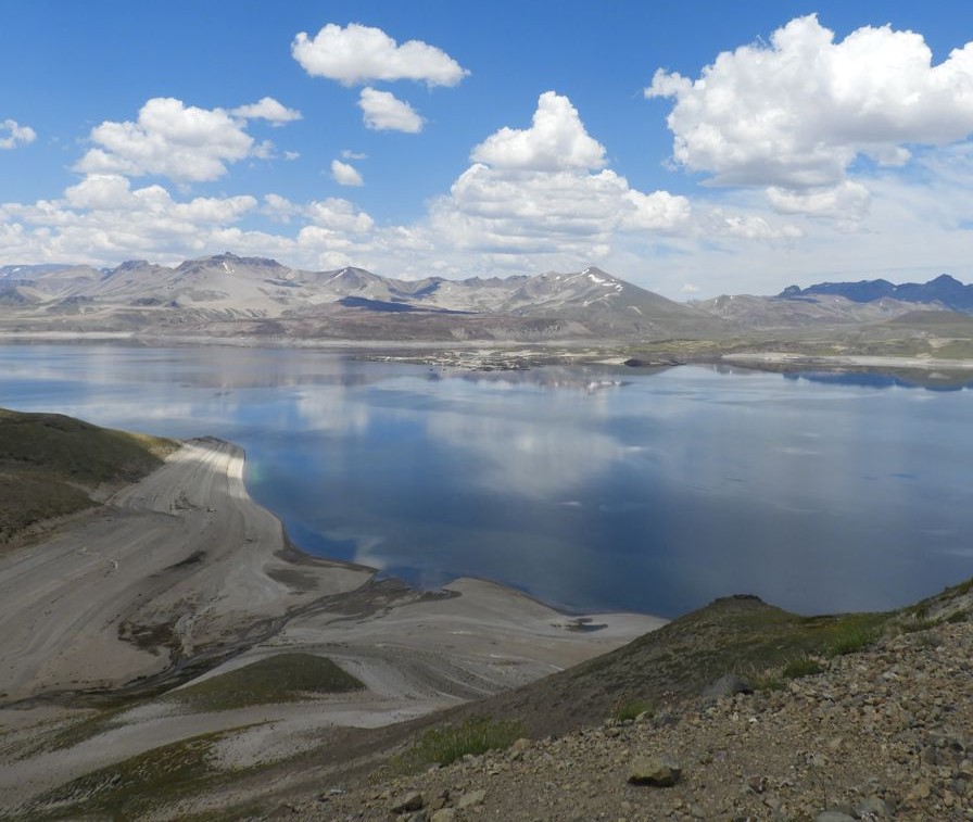
Chile , Laguna del Maule :
For the period under review, volcano-tectonic (VT) seismic activity, associated with rock fracturing within the volcano, showed a decrease in the number of recorded events compared to the previous period. However, their energy release levels were similar to those of the previous period. The highest-energy VT event recorded had a local magnitude (ML) of 3.2 and was located 7.5 km south-southwest (SSW) of the lagoon center, at a depth of 6.0 km, according to the REAV.
Seismic activity associated with fluid movement within the volcano, represented by long-period (LP) events, recorded a similar number of events to the previous period, as well as similar energy release levels. The most energetic event, measured by its reduced displacement (Dr), recorded a value of 2.4 cm².
Data from GNSS stations located near the volcanic complex showed values similar to those of the previous period, for both vertical and horizontal deformation rates. Both rates remain high compared to the reference level.
Images from surveillance cameras installed in the area near the volcanic complex did not reveal any surface activity associated with it. Furthermore, processing of the satellite images did not detect any thermal anomalies associated with the volcanic complex.
CONCLUSIONS
During the assessed period, seismic activity at the volcanic complex remained stable compared to the previous two weeks, with strong volcano-tectonic (VT) activity associated with rock fracturing within the volcano. A slight decrease in the daily frequency of events was observed during this period compared to previous months, with multiple foci distributed mainly in the southwest, east, and central sectors of the lagoon. A high-energy event, reaching a local magnitude (ML) of 3.2 according to the REAV system, was particularly noteworthy during this period.
Furthermore, the large-scale deformation process continues, exhibiting high inflation rates compared to historical instrumental data.
In this context, the continued seismic activity and the persistence of the inflation process indicate that the volcanic system remains unstable, exceeding its baseline activity levels. Therefore, as a precautionary measure, the technical alert level remains yellow. Monitoring of the volcano will continue in constant communication with the Southern Andes Volcanological Observatory (OVDAS) of Chile, and any changes will be reported.
Source : Senapred
Photo : Sernageomin
Colombia , Purace – Los Coconucos volcanic chain:
Popayán, December 19, 2025, 8:30 a.m.
Regarding the monitoring of activity in the Los Coconucos volcanic chain, the Geological Survey of Colombia (SGC), an agency under the Ministry of Mines and Energy, reports the following:
Since the publication of yesterday’s extraordinary bulletin, and continuing to this day, seismic activity related to fluid movements within the volcanic edifice has persisted. This includes long-period (LP) earthquakes, seismic pulses (TR), and continuous tremor. This seismicity has been localized beneath the Puracé volcano crater, at a depth of less than 1 km, and is linked to the internal dynamics of gases and their emission into the atmosphere. In addition, low-magnitude seismic signals associated with rock fracturing were recorded, primarily beneath the Puracé and Piocollo volcanoes, at depths of 1 to 2 km. Some of these seismic signals were associated with ash emissions that dispersed mainly to the west and southwest, following the wind direction, and reached altitudes of up to 1,700 m above the volcano summit. A total of seven (7) ash emissions were recorded, for which alerts were issued to the Civil Aviation Authority.
Ashfall has been reported in the Río Negro area and at the Paletará Indigenous Council House, and gas odors have been reported in the village of Chapa, in the municipality of Sotará, located southwest of the volcano.
Significant emissions of sulfur dioxide (SO₂) in the atmosphere continue to be detected by satellite, with a predominant dispersion southwest of the volcano’s crater. Similarly, temperatures comparable to those recorded in previous days continue to be observed in the crater area, likely related to the emission of hot gases from within the volcano. According to surface activity monitoring of the Curiquinga volcano, continuous degassing has been recorded at the fissure on the northern wall of the crater since November 18, 2025, without ash emissions.
With the orange alert remaining in effect, temporary fluctuations in volcanic activity are possible. This level may therefore decrease temporarily compared to previous days or weeks. However, this does not necessarily indicate a return to stable activity. For a return to yellow alert (a sign of greater stability), a reasonable timeframe is necessary to assess all monitored parameters and detect any trends indicating such a return.
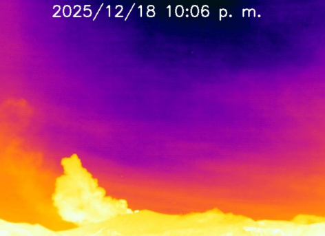
Thermal image of El Púlpito, located 6 km south-southwest of the Puracé volcano. Gas and ash plume recorded at 10:06 PM on December 18, 2025.
Given the above, the Colombian Geological Survey (SGC) recommends staying away from the Puracé volcano crater and its surroundings, closely monitoring volcanic activity through bulletins and information disseminated through official channels, and adhering to the instructions of local and departmental authorities and the National Unit for Disaster Risk Management (UNGRD).
The volcanic activity level remains at ORANGE alert: Volcano with significant variations in monitored parameters.
Source et photos : SGC
La Réunion Island , Piton de la Fournaise :
Press Release from the Paris Institute of Earth Physics / Piton de la Fournaise Volcanological Observatory
December 19, 2025 – 10:00 AM local time – 6:00 AM UTC
Seismicity
The decrease in seismic activity at the summit of Piton de la Fournaise was confirmed at the end of last week (Figure 1).
Since Friday, December 12, the number of shallow volcano-tectonic earthquakes (0 to 2.5 km above sea level) recorded beneath the summit has remained stable, with between 11 and 15 events per day. Even though this seismic activity is decreasing compared to previous weeks, it remains higher than the average observed since 2023. The continuation of this seismicity suggests that the shallow magma reservoir remains under pressure.
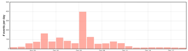
Figure 1: Histogram showing the number of shallow volcano-tectonic earthquakes per day recorded since November 26, 2025 (© OVPF-IPGP).
Deformation
The inflation (swelling) of the edifice continues, although it has slowed over the past week. Since the end of November, surface displacements recorded by the OVPF-IPGP GPS stations indicate an expansion of the summit area of approximately 2.5–3 cm, confirming the pressurization of the shallow magma supply system.
Gas Emission at the Summit
SO2 and H2S concentrations in the atmosphere at the summit of the volcano remain close to detection levels. Low concentrations of H2S and SO2 (<0.3 ppmv) are associated with vapor pulses (H2O) and correspond to emissions from the hydrothermal system within the Dolomieu crater. Detections of low sulfur concentrations above the baseline, recorded since November 10, 2025, are currently continuing.
Summary
Continued seismic activity and the slow inflation of the summit area indicate that the pressurization of the shallow magma reservoir continues, even though it has slowed down over the past week. This pressurization process can last from several days to several weeks, or even several months, before the reservoir roof ruptures, resulting in magma being injected towards the surface and potentially triggering an eruption. However, it can also cease without leading to an eruption in the short term.
Alert level: Vigilance
Source et photos : direction de l’OVPF-IPGP