December 13 , 2025.
Hawaii , Kilauea :
HAWAIIAN VOLCANO OBSERVATORY DAILY UPDATE , U.S. Geological Survey
Friday, December 12, 2025, 9:37 AM HST (Friday, December 12, 2025, 19:37 UTC)
19°25’16 » N 155°17’13 » W,
Summit Elevation 4091 ft (1247 m)
Current Volcano Alert Level: WATCH
Current Aviation Color Code: ORANGE
Activity Summary:
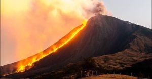
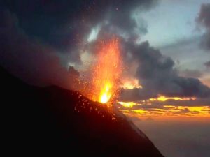
The ongoing summit eruption at Kīlauea is paused. Moderate glow continued overnight in the vents. The onset of episode 39 is likely to occur between December 21 and 27.
Summit Observations:
Glow continued overnight from both vents. Sustained tremor punctuated by gas pistoning at irregular intervals continues this morning.
Since the end of episode 38, Kīlauea has inflated 13.9 microradians as recorded on the UWD tiltmeter this morning with an increase of 1.9 microradians over yesterday.
Volcanic gas emissions have greatly decreased with the end of the eruption and are back in the normal range of 1200 to 1500 tonnes per day of SO2.
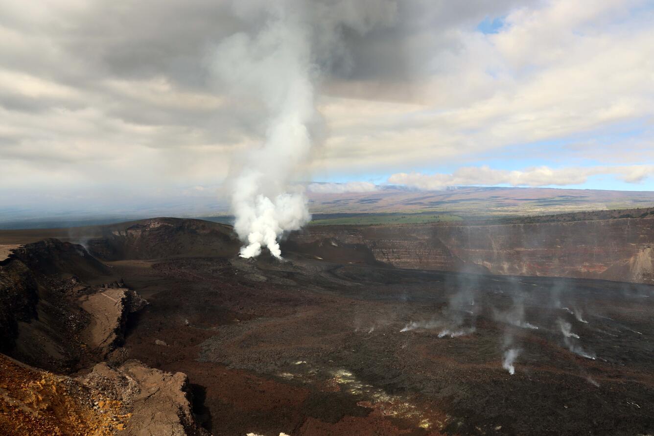
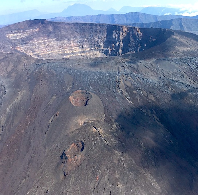
On Tuesday, December 9, USGS-Hawaiian Volcano Observatory geologists conducted a helicopter overflight of Kīlauea summit to survey changes from episode 38 lava fountaining a few days earlier. Scientists collected visual images for photogrammetry, thermal images, and collected lava samples from the caldera floor. They observed widespread deposition of tephra southwest of the vents from episode 38 fountaining, covering more of the closed portions of Crater Rim Drive. In this photo, outgassing plumes rise passively from the north and south vents.
Rift Zone Observations:
Rates of seismicity and ground deformation remain very low in the East Rift Zone and Southwest Rift Zone. SO2 emissions from the East Rift Zone remain below the detection limit.
Analysis:
The rapid rebound of inflationary tilt, continued tremor, and moderate glow from both vents overnight all indicate another fountaining episode is likely. The onset of episode 39 is likely to occur between December 21 and 27. The forecast interval may become tighter as more data becomes available.
Kīlauea has been erupting episodically since December 23, 2024, primarily from two vents (north and south) in Halema‘uma‘u. Eruptive episodes, which can last up to 12 hours, are separated by pauses that can be as long as two weeks.
HVO continues to closely monitor Kīlauea and is in contact with Hawai‘i Volcanoes National Park and the Hawai‘i County Civil Defense Agency about eruptive hazards.
Source : USGS
Photo : USGS/ C. Sealing
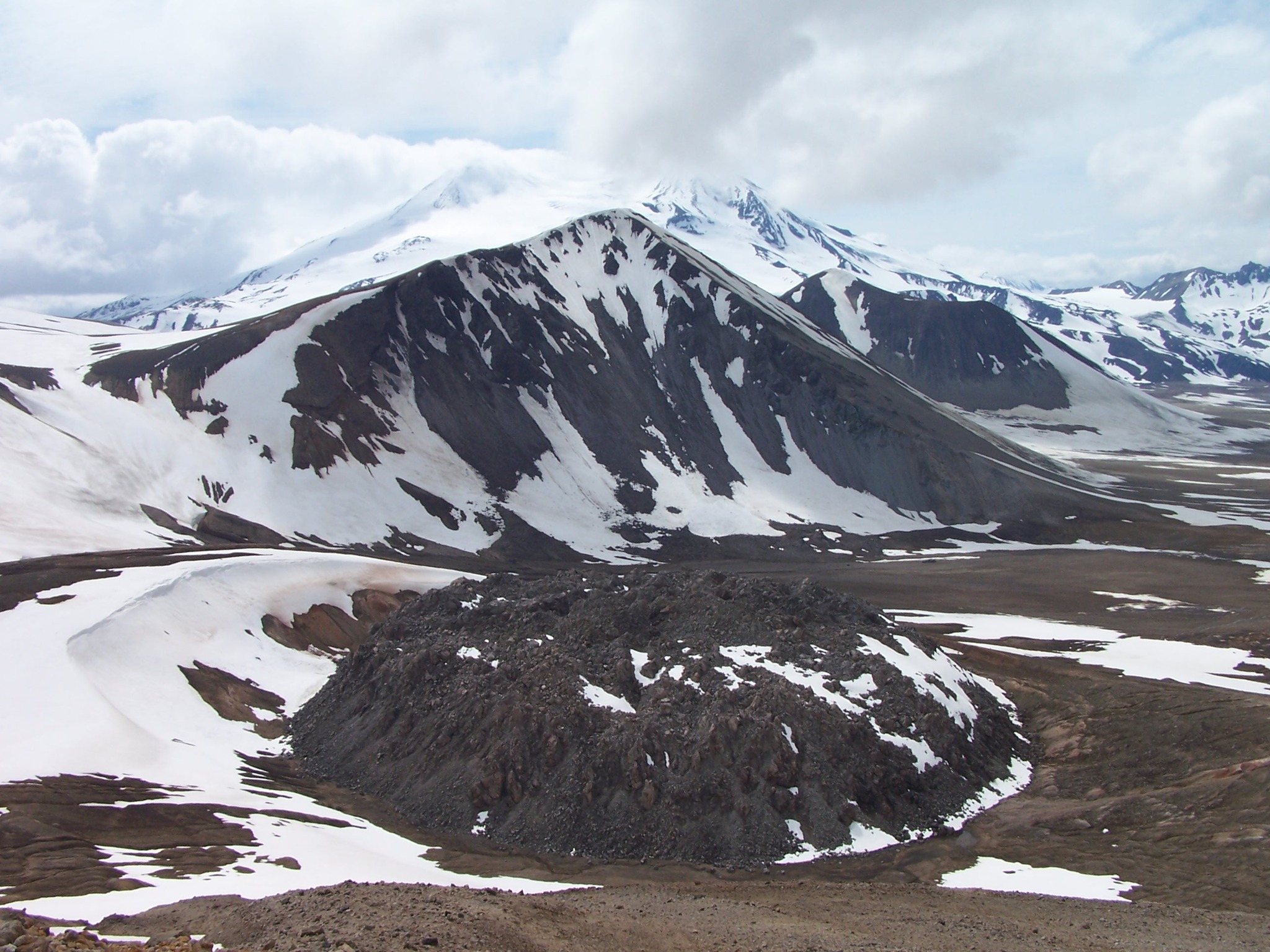
Alaska , Katmai :
ALASKA VOLCANO OBSERVATORY INFORMATION STATEMENT , U.S. Geological Survey
Friday, December 12, 2025, 1:00 PM AKST (Friday, December 12, 2025, 22:00 UTC)
58°16’44 » N 154°57’12 » W,
Summit Elevation 6716 ft (2047 m)
Current Volcano Alert Level: NORMAL
Current Aviation Color Code: GREEN
Strong northwesterly winds in the vicinity of Katmai and the Valley of Ten Thousand Smokes have picked up loose volcanic ash erupted during the 1912 Novarupta-Katmai eruption and are carrying it to the southeast. The National Weather Service has issued a SIGMET for this low-level event and suggests that the maximum cloud height is 6,000 ft (1.8 km) above sea level.
This phenomenon is not the result of recent volcanic activity and occurs during times of high winds and dry snow-free conditions in the Katmai area and other young volcanic areas of Alaska. No eruption is in progress. All of the volcanoes of the Katmai area (Griggs, Katmai, Novarupta, Mageik, Martin, Snowy and Trident) remain at Aviation Color Code GREEN and Alert Level NORMAL. Resuspended volcanic ash should be considered hazardous and could be damaging to aircraft and health.
Source : AVO
Photo : P. Izbekov, AVO/UAF-GI. USGS, DGGS .
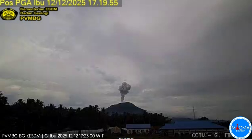
Indonesia , Ibu :
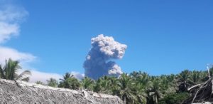
Mount Ibu erupted on Friday, December 12, 2025, at 5:18 PM WIT. An ash column was observed approximately 800 meters above the summit (at an altitude of about 2,125 meters). This ash column, white to gray in color, was moderately to strongly intense and drifted southwest. The eruption was recorded by a seismograph, with a maximum amplitude of 28 mm and a duration of 61 seconds.
Seismic Observations
85 eruption earthquakes with amplitudes of 15 to 28 mm and durations of 42 to 95 seconds.
3 emission earthquakes with amplitudes of 6 to 9 mm and durations of 57 to 78 seconds.
14 harmonic tremors with amplitudes of 2 to 15 mm and durations of 28 to 137 seconds.
110 low-frequency earthquakes with amplitudes of 2 to 13 mm and durations of 17 to 29 seconds.
133 shallow volcanic earthquakes with amplitudes of 2 to 6 mm and durations of 7 to 21 seconds.
3 deep volcanic earthquakes with amplitudes of 2 to 14 mm and durations of 17 to 20 seconds.
A local tectonic earthquake with a magnitude of 3 mm and a duration of 43 seconds was recorded.
Nine distant tectonic earthquakes with magnitudes ranging from 2 to 16 mm and durations from 29 to 164 seconds were also recorded.
Recommendations
1. Residents living around Mount Ibu and visitors/tourists are advised to refrain from all activities within a 2 km radius and a 3.5 km sector around the crater opening in the northern part of the active Mount Ibu crater.
2. In the event of ashfall, people engaging in outdoor activities are advised to wear a mask covering their nose, mouth, and eyes, as well as protective eyewear.
Source et photo : PVMBG.
Colombia , Nevado del Ruiz :
Manizales, December 9, 2025, 12:15 PM
Regarding the monitoring of activity at the Nevado del Ruiz volcano, the Colombian Geological Survey (SGC), an agency under the Ministry of Mines and Energy, reports the following:
During the week of December 2-8, 2025, the volcano continued to exhibit unstable behavior. Compared to the previous week, the main variations in monitored parameters were as follows:
– Seismicity associated with fluid dynamics in volcanic conduits, corresponding to short- and long-duration signals, decreased in the number of events and in seismic energy released. The energy levels recorded were low, and no ash emissions were confirmed in connection with these events.
– Seismic activity associated with rock fracturing processes within the volcanic edifice remained at similar levels in terms of the number of recorded earthquakes and seismic energy released. The earthquakes were primarily located within the Arenas crater, at depths of up to 2 km. Seismic activity continued along the volcano’s flanks, extending up to 12 km from the crater and at depths between 2 and 9 km from the summit. The northeast, south-southwest, and west-southwest flanks exhibited the highest concentration of seismicity. The highest recorded magnitude was 1.0, corresponding to the earthquake of December 3 at 1:30 PM, located within the Arenas crater at a depth of 1 km.
On December 4, low-intensity seismic activity related to the lava dome (protuberance or mound) at the bottom of the crater was also recorded. Emissions of water vapor and volcanic gases, primarily sulfur dioxide (SO₂), into the atmosphere continued through the Arenas crater. Estimated daily SO₂ fluxes showed variability, with low values and a decrease compared to the previous week. These values are partly explained by winds whose direction and speed remained unfavorable to the monitoring stations. Additional satellite monitoring also continued to show low levels of SO₂ emissions.
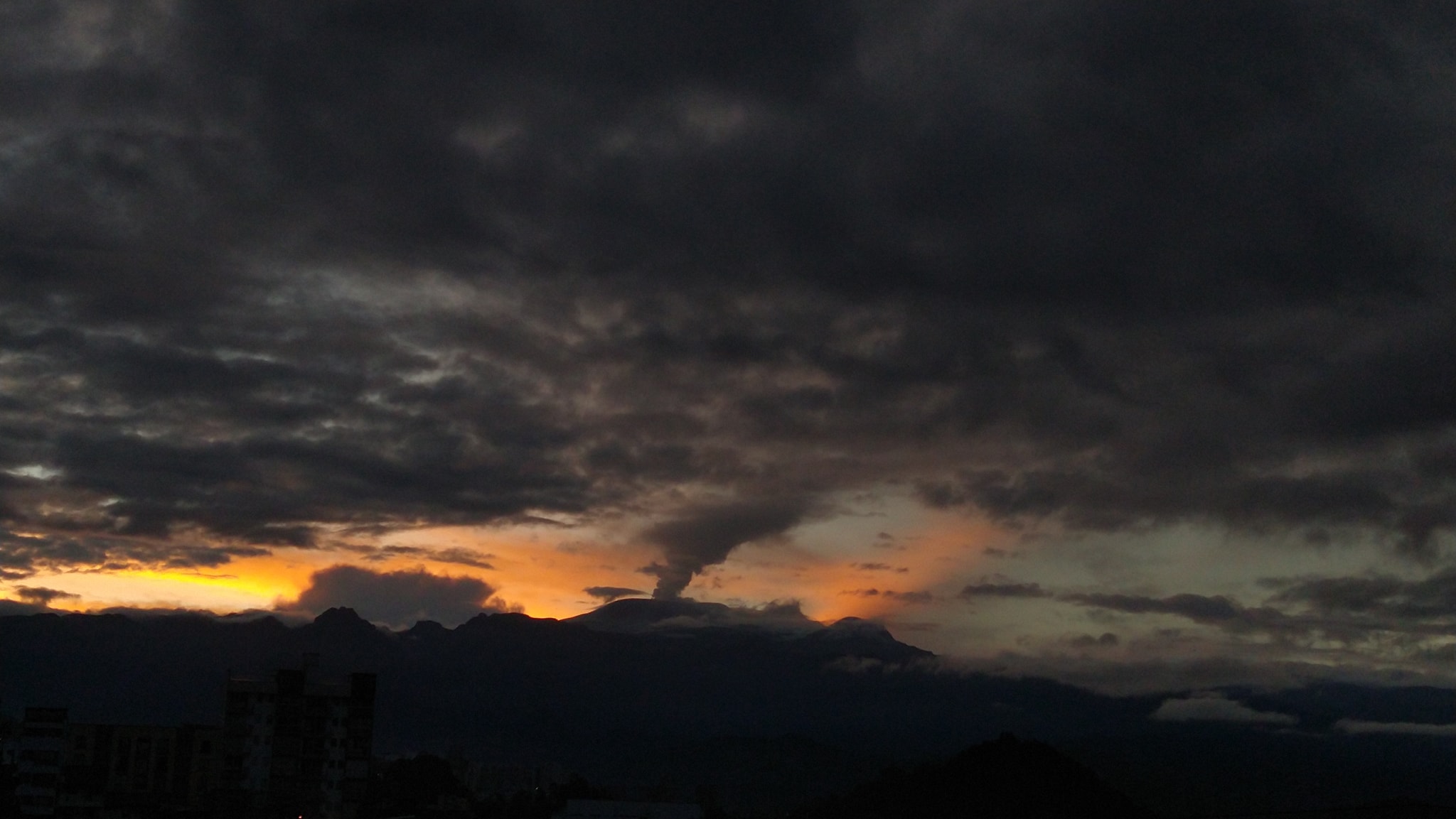
– The vertical height of the column of gas, water vapor, or ash reached a maximum of 1,000 m, measured above the summit of the volcano on the morning of December 8. The direction of dispersion of the column varied between the southeast, northwest, northeast, east-northeast, and west-southwest flanks of the volcanic structure.
– Following satellite monitoring of thermal anomalies at the bottom of Arenas Crater, several low-energy anomalies were detected.
Source : SGC.
Photo : Julian Fernando Aranzazu Henao.
La Réunion Island , Piton de la Fournaise :
Press release from the Paris Institute of Earth Physics / Piton de la Fournaise Volcanological Observatory, December 12, 2025 – 1:30 PM local time – 9:30 AM UTC
Following the magmatic intrusion that occurred during the night of December 5-6 (see press release of December 6, 2025, 6:00 PM for more details on this event), seismicity at Piton de la Fournaise has significantly decreased compared to the peak observed during the seismic crisis (397 summit volcano-tectonic earthquakes on December 5, Figure 1).
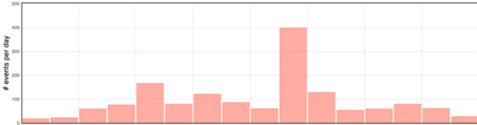
Figure 1: Histogram showing the number of shallow volcano-tectonic earthquakes per day recorded since November 26, 2025 (© OVPF-IPGP).
Seismic activity remains significant, with an average of around fifty earthquakes per day recorded over the past five days. The most recent data suggest a downward trend in activity since Tuesday, December 9, a trend that will need to be confirmed by developments in the coming days.
During the intrusion of December 5, seismicity was mainly concentrated beneath the eastern rim of the Dolomieu crater. Since then, earthquakes have once again been distributed along the entire annular fault, a large circular structure surrounding the summit, located between the magma reservoir and the surface. This trend indicates a return to a seismic regime primarily controlled by pressure variations within the magma reservoir, rather than by shallow magma injection from this reservoir to the surface.
Since the end of November, surface displacements recorded by the OVPF-IPGP GPS stations indicate an expansion of the summit zone of approximately 2 cm, reflecting slow inflation of the volcano and confirming the pressurization of the shallow magma reservoir (Figures 3 and 4). This inflation continued over the last five days. However, for the past two days, this inflation appears to have slowed considerably. This parameter will be monitored in the coming days to determine whether this slowdown leads to a halt in inflation. Deep seismicity beneath the Plaines region (particularly under the Plaine des Palmistes) continues, indicating persistent activity of the deep magmatic system.
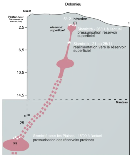
Schematic view of the Piton de la Fournaise magma supply system showing the main phases of reactivation observed since mid-September 2025. Note that the earthquakes are of very low magnitude, and most cannot be located. The white stars represent the schematic locations of the earthquakes.
SO2 and H2S concentrations in the atmosphere at the summit of the volcano remain close to detection levels.
Low concentrations of H2S and SO2 (<0.3 ppmv) are associated with steam pulses (H2O) and correspond to emissions from the hydrothermal system within the Dolomieu crater. Detections of low sulfur concentrations above the baseline, recorded since November 10, 2025, are continuing.
The continued seismicity and the slow inflation of the summit area indicate that the pressurization of the shallow magma reservoir is ongoing, even if it has slowed down in recent days. This pressurization process of the shallow reservoir can last from several days to several weeks before the reservoir roof ruptures, resulting in magma being injected towards the surface and potentially triggering an eruption. However, it can also cease without leading to an eruption in the short term.
Alert level: Vigilance
Source : direction de l’OVPF-IPGP
Photos : OVPF