December 7 , 2025.
Hawaii , Kilauea :
HVO/USGS Volcanic Activity Notice
Current Volcano Alert Level: WATCH
Current Aviation Color Code: ORANGE
Issued: Saturday, December 6, 2025, 8:48 AM HST
Source: Hawaiian Volcano Observatory
Notice Number: 2025/H535
Location: N 19 deg 25 min W 155 deg 17 min
Elevation: 4091 ft (1247 m)
Area: Hawaii
Volcanic Activity Summary:
Episode 38 of the ongoing Halemaʻumaʻu eruption began at 8:45 a.m. HST on December 6 with steeping increasing tremor and decreasing tilt. Sustained lava fountains approximately 50-100 feet (15-30 meters) in height are currently erupting from the north vent. Fountain heights are increasing rapidly and are coming from both the left and right vents within the north cone..
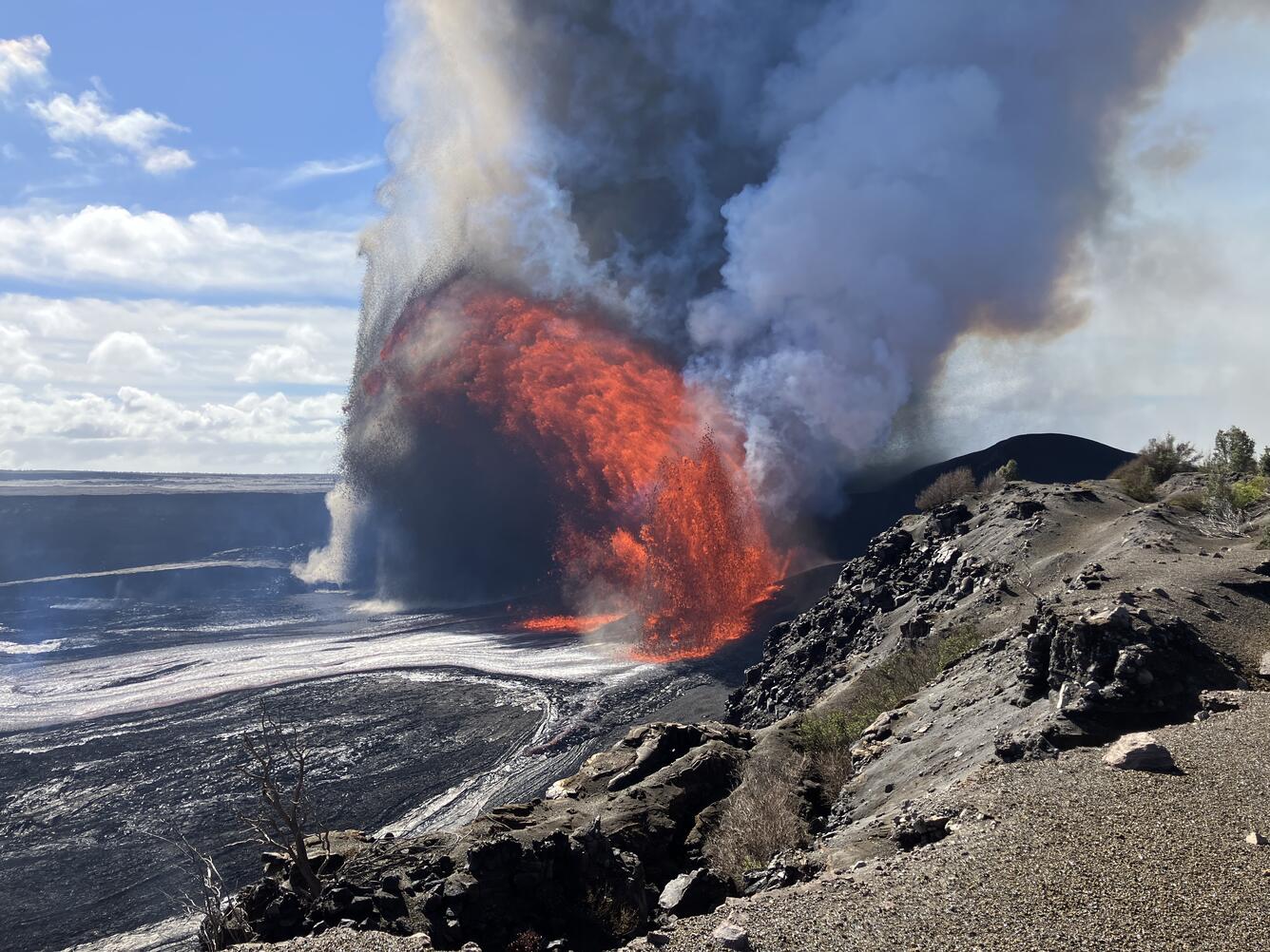
On December 6, USGS Hawaiian Volcano Observatory geologists monitored and measured the Kīlaeua summit eruption episode 38 from multiple vantage points. This photo was captured around 10:00 a.m. from the northwest rim of the crater, near the V1 live-streaming webcam, with vigorous lava fountains underway at both the north and south vents.
Past episodes have produced incandescent lava fountains over 1000 feet (300 meters) high that produce eruptive plumes up to 20,000 feet (6000 meters) above ground level. The spilt nature of the north vent suggest episode 38 may produce lower fountains similar to episode 37 when the same two vents existed in the north cone. According to the National Weather Service, winds are blowing from the north northeast at about 10 mph (5 m/s), which suggests that volcanic gas emissions and volcanic material may be distributed south of Halema’uma’u..
All eruptive activity is confined to Halemaʻumaʻu crater within Hawaiʻi Volcanoes National Park; commercial airports in Hawaii County (KOA and ITO) will not be affected by this activity.
Episode 38 was preceded by small, sporadic spatter fountains and 6 precursory overflows from the north vent that began at approximately 12:50 p.m. December 5. Continuous overflows began at 3:37 a.m. HST and increased in intensity until 8:45 a.m., when sustained fountaining began.
Inflationary tilt reached just over 16.6 microradians since the end of the last episode. Seismic tremor began increasing and tilt at UWD switched from inflationary to deflationary at about 7:45 a.m. HST, about the same time increased lava output began from the north vent.
Most episodes of Halemaʻumaʻu lava fountaining since December 23, 2024, have continued for around a day or less and have been separated by pauses in eruptive activity lasting generally at least several days.
Kīlauea Volcano Alert Level/Aviation Color Code remain at WATCH/ORANGE. All current and recent activity is within Hawaiʻi Volcanoes National Park.
Issued: Saturday, December 6, 2025, 9:08 PM HST.
Volcanic Activity Summary:
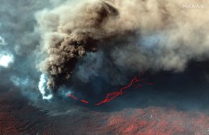
Episode 38 of the ongoing Halemaʻumaʻu eruption ended abruptly at 8:52 p.m. HST on December 6 after 12.1 hours of continuous lava fountaining.
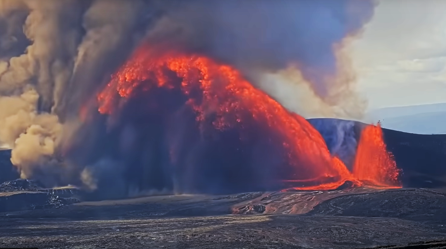
The south vent stopped erupting at approximately 8:52 p.m. HST, marking the end of the episode. The dual north vents stopped erupting much earlier at approximately 11:50 a.m. Lava fountains reached heights of up to 1,000-1,200 ft (300-370 m) during episode 38. Fountains were down to about 400 feet (120 meters) high just before the abrupt end of the eruption. Lava fountaining lasted for 12.1 hours and produced an estimated 16 million cubic yards (12 million cubic meters) of lava. The combined average eruption rate was over 250 cubic yards per second (190 cubic meters per second) from the lava fountains.
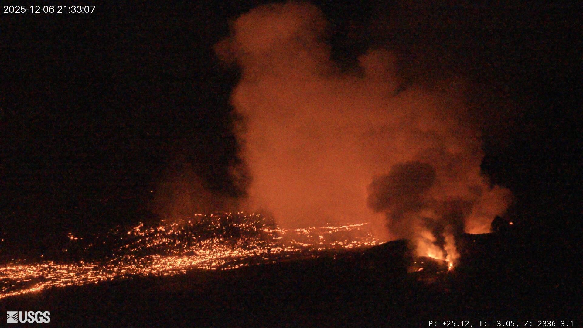
Sustained lava fountains began erupting from two vents located within the north cone at 8:45 a.m. HST on December 6 after just over 5 hours of precursory lava overflows. The south vent then began fountaining at 8:49 a.m. By 9:15 a.m. a rare triple fountain event was underway with the two north vents and the south vent all erupting together at heights of about 500 feet (150 meters). By 9:40 a.m. the south vent fountain grew to about twice as high as the north vent fountains. The highest peak or instantaneous effusion rate of 1,300 cubic yards per second (1,000 cubic meters per second) occurred just before 10 a.m. when the south vent exploded. The enlarged south vent produced an inclined fountain over 1,000 feet (300 meters) tall that sprayed the south wall of Halemaʻumaʻu crater. Hot pumice and molten spatter from this fountain destroyed the HVO « V3 » streaming camera site.
Lava flows from this episode’s fountains covered 50-60% of the floor of Halemaʻumaʻu crater. Lava flows near the vents and on the floor of Halemaʻumaʻu within the southern part of Kaluapele (Kīlauea caldera) may continue to exhibit slow movement or incandescence as they cool and solidify over the coming days.
Source : HVO.
Photos : USGS / M. Zoeller , USGS.
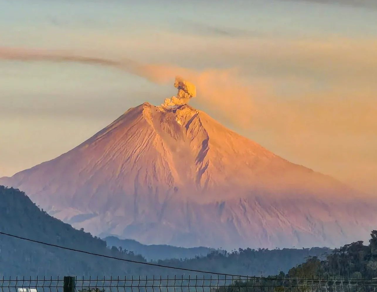
Kamchatka , Sheveluch :
VOLCANO OBSERVATORY NOTICE FOR AVIATION (VONA)
Issued: 20251207/0145Z
Volcano: Sheveluch (CAVW #300270)
Current aviation colour code: ORANGE
Previous aviation colour code: orange
Source: KVERT
Notice Number: 2025-151
Volcano Location: N 56 deg 38 min E 161 deg 18 min
Area: Kamchatka, Russia
Summit Elevation: 3283 m (10768.24 ft), the dome elevation ~2500 m (8200 ft)
Volcanic Activity Summary:
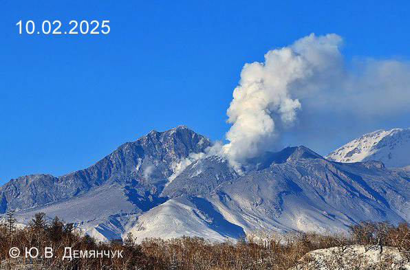
A growth of the lava dome of the Young Sheveluch volcano continues, this process is accompanied by powerful gas-steam emissions. Satellite data by KVERT showed a thermal anomaly on the volcano; an explosion sent ash up to 3.6 km a.s.l., and ash plume extended for 40 km to the northeast of the volcano.
The explosive-extrusive eruption of the volcano continues. The danger of ash explosions up to 12 km (39,400 ft) a.s.l. remains. Ongoing activity could affect international and low-flying aircraft.
Volcanic cloud height:
3600 m (11808 ft) AMSL Time and method of ash plume/cloud height determination: 20251207/0110Z – Himawari-9 14m15
Other volcanic cloud information:
Distance of ash plume/cloud of the volcano: 40 km (25 mi)
Direction of drift of ash plume/cloud of the volcano: NE / azimuth 36 deg
Time and method of ash plume/cloud determination: 20251207/0110Z – Himawari-9 14m15
Source : Kvert
Photo : Yu. Demyanchuk. IVyS Branche extrême-orientale de l’Académie des sciences de Russie, KVERT.
Chile , Planchon Peteroa :
Seismology
The seismic activity of the period was characterized by the recording of:
55 VT-type seismic events, associated with rock fracturing (volcano-tectonics). The strongest earthquake, with a local magnitude (ML) of 2.4, was located 6.9 km east-southeast of the volcanic edifice, at a depth of 9.9 km.
1,873 LP-type seismic events, associated with fluid dynamics within the volcanic system (long period). The amplitude of the largest earthquake, measured by the reduced displacement parameter (DR), was 31 cm².
3,152 TR-type seismic events, associated with sustained fluid dynamics within the volcanic system (TRemor). The amplitude of the largest earthquake, measured by the reduced displacement parameter (DR), was 11 cm².
Fluid Geochemistry
Six anomalies in sulfur dioxide (SO2) emissions into the atmosphere were reported near the volcanic complex, according to data published by Geoservice. Similarly, the Mounts platform recorded a peak emission mass of 44 tonnes for the period of November 23, which is consistent with observed surface activity and incandescence, possibly linked to a larger magmatic component during this period.
Satellite Thermal Anomalies
According to the analytical processing of images from the Sentinel-2-L2A satellite, recurring thermal radiation anomalies were recorded between November 18 and 30. These anomalies reached a maximum area of 3,200 m², estimated by the NHI Tools algorithm on November 18. Furthermore, the MIROVA (Mid-Infrared Volcanic Activity Observation) sensors recorded a thermal anomaly of 2.1 MW on VIIRS 750 on November 22, and 18 anomalous values on VIIRS 350, with a maximum of 2.4 MW on November 23. Finally, MODIS recorded three radiative power values, the highest of which was 1.9 MW, on November 18.
Surveillance Cameras
Images from fixed cameras recorded degassing and constant nighttime incandescence.
Regarding explosive activity, a decrease was observed compared to the previous period, based on the lower frequency of pyroclastic emissions and the reduced column height, with a maximum of 1,100 m above the crater rim (November 16 and 23). No ballistic projectile emissions were detected during this period.
Satellite Geomorphological Analysis
Based on the photo-interpretation of false- and true-color SkySat Collect, PlanetScope, and Sentinel-2LA satellite images, the following conclusions were drawn:
– Pyroclastic material emissions generated deposits associated with pyroclastic fallout, with a maximum range of 4.1 km to the east, 13 km to the south, and 4.3 km to the southeast. The latter two directions are primarily distributed across the national territory, while the deposits to the east are mainly located in Argentina. Areas of maximum activity are associated with events involving passive pyroclastic emissions and/or low explosivity, monitored by surveillance cameras on November 18, 25, and 26. Simultaneously, in SkySat images from November 15 and 21, impact craters and blocks associated with ballistic emissions were identified through photo-interpretation within a 230-meter radius of the center of the Southwest Crater, along with signs of higher temperatures within the crater.
Specifically, in the November 21 image, a radiance/incandescence sector was identified inside the crater.
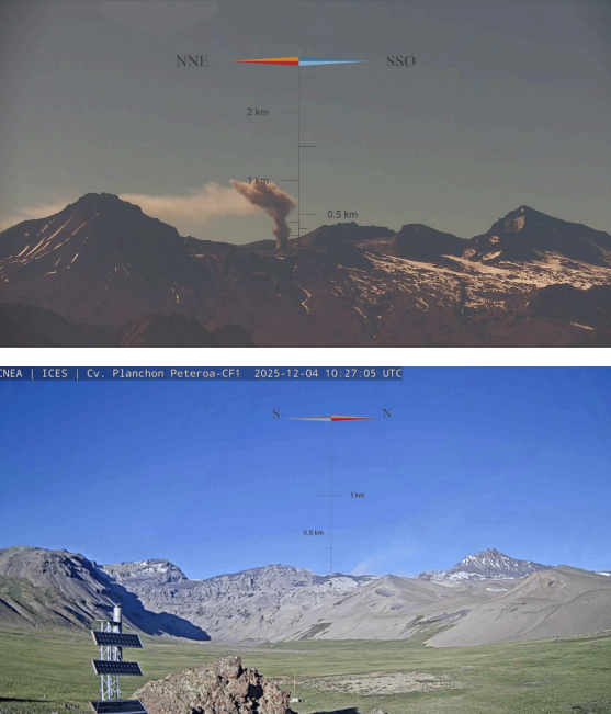
Sequence of images from the Planchón-Peteroa volcano surveillance cameras, corresponding to the time interval between the start of the eruption and the publication of this report. The emission of fine particles (volcanic ash) from the area of the active craters is observed.
– The activity visible in the satellite images is concentrated exclusively in the Southwest Crater, from which the constant emission of gas and/or pyroclasts originates. Since this period, and due to recent volcanic activity, the absence of the crater lake described previously is confirmed. Regarding the surrounding craters, an increase in the surface area of the Northwest Crater Lake has been observed, rising from 9,661 to 12,227 m² over the last two weeks. The Northeast Crater Lake has reached 637 m².
No morphological changes were detected, suggesting pyroclastic material emissions or other forms of volcanic activity from the surrounding craters.
During the second half of November, the Planchón-Peteroa volcanic complex exhibited a decrease in the energy of the continuous seismic signal (tremor) and the discrete seismicity index (LP). A decrease in processes associated with pyroclastic material emissions was also observed at the surface, with the persistence of low-power pulsatile gas emissions until the end of the month, without any recent signs of energetic pulses.
However, a radiation zone was detected inside the Southwest Crater, the area with the highest surface temperature. Furthermore, fracturing events (VT) associated with a source located in the southeast sector of the active craters have been observed. These events have historically been linked to the activity of the volcanic complex.
All of this information indicates that, despite lower energy levels in surface processes, signs persist, demonstrating the continuity of an unstable system with fluid interaction and active seismic sources. Therefore, the volcanic technical alert remains at the following level:
YELLOW TECHNICAL ALERT: Changes in volcanic activity behavior.
Source : Sernageomin
Photos : Segemar .
La Martinique , Mount Pelée :
Weekly Report, Paris Institute of Earth Physics / Martinique Volcanological and Seismological Observatory
Saint-Pierre, December 5, 2025, 2:30 p.m. local time (GMT-4)
Volcanic activity is stable this week with 27 volcanic earthquakes observed.
Between November 28, 2025, 4:00 p.m. UTC and December 5, 2025, 4:00 p.m. UTC, the Martinique Volcanological and Seismological Observatory recorded:
27 shallow volcano-tectonic earthquakes of very low energy. These earthquakes originated from the well-known seismically active zones of Mount Pelée, located between 1.0 and 1.4 km deep below the volcano’s summit. Shallow volcano-tectonic seismicity is associated with microfracturing in the volcanic edifice, linked to the overall reactivation of the volcano observed since 2019.
No earthquakes have been felt by the population.
The previous week, the OVSM (Mountain Seismological Observatory) recorded 18 volcanic earthquakes. As of December 5, 2025, and over the past four weeks, the OVSM has observed a total of 339 volcanic earthquakes, an average of 84 to 85 earthquakes per week.
During phases of volcanic reactivation of volcanoes similar to Mount Pelée, seismic activity of varying intensity and frequency is common. The probability of an eruptive activity in the short term remains low. However, considering all the observations collected since the end of 2018 and their nature, and based on recent observations from the OVSM-IPGP (Paris Institute of Earth Physics), we cannot rule out a change in the situation in the medium term (weeks, months).
For more details on observations and interpretations of volcanic activity over the longer term, please refer to the OVSM’s monthly bulletins.
The volcanic alert level, in accordance with the provisions made by the authorities, is currently YELLOW: vigilance.
Source : Direction de l’OVSM-IPGP.
Photo : Parc naturel Martinique
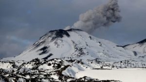
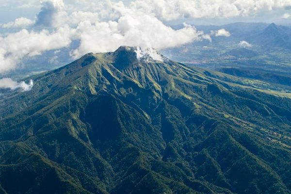
Ecuador , Sangay :
DAILY REPORT ON THE STATE OF SANGAY VOLCANO, Saturday, December 6, 2025.
Geophysical Information Institute – EPN.
Surface Activity Level: Moderate, Surface Trend: No Change
Internal Activity Level: Moderate, Internal Trend: No Change
Seismicity: From December 5, 2025, 11:00 AM to December 6, 2025, 11:00 AM:
Seismicity:
Below is the count of seismic events recorded at the reference station:
Explosion (EXP): 153
Rainfall/Lahars:
No rain has been recorded in the volcanic area. **Heavy rainfall could remobilize accumulated material, generating mudflows and debris flows that would cascade down the volcano’s flanks and flow into adjacent rivers.**
Emission/Ash Column:
Last night, the GOES-19 satellite system observed a gas and ash plume reaching an altitude of 700 meters above the crater, drifting southeast. The Washington VAAC agency also reported a gas and ash plume reaching an altitude of 600 meters above the crater, also drifting southeast.
Other monitoring parameters:
Over the past 24 hours, the FIRMS satellite system recorded 20 thermal anomalies, the MIROVA VIIRS 375 system recorded 4, the MIROVA VIIRS 750 system recorded 3, and the MIROVA MODIS system recorded 2.
Note:
At the time of writing, the area around the volcano remained mostly cloudy.
Alert level: Yellow
Source : IGEPN
Photo : Cristopher Cardenas / volcan Sangay / FB.