December 01 , 2025.
Indonesia , Ili Werung :
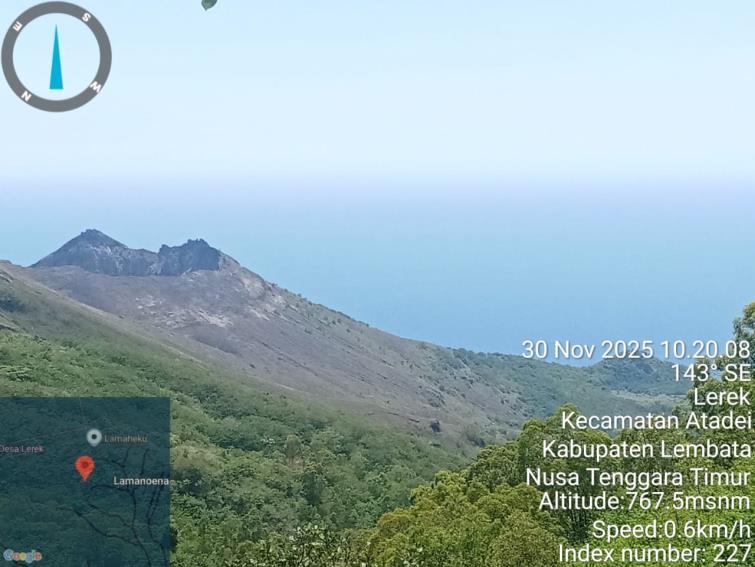
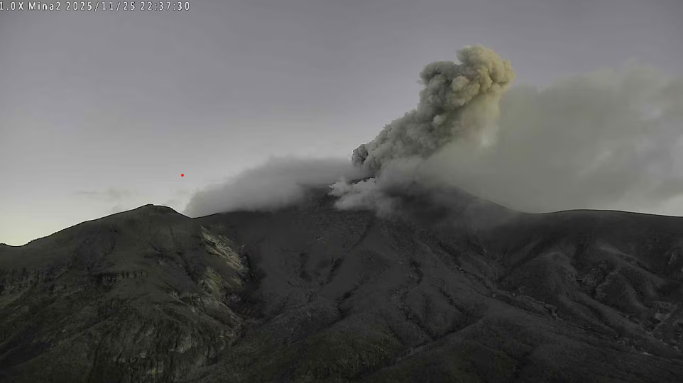
Increase in the activity level of Mount Ili Werung, in East Nusa Tenggara province, from Level I (normal) to Level II (WASPADA) on November 30, 2025.
Mount Ili Werung is a stratovolcano with a summit of 1,486 meters. It is located at coordinates 08° 32’ 24” S and 123° 35’ 24” E. Administratively, it lies within the Lembata Regency, East Nusa Tenggara province.
From November 1 to 30, 2025, no volcanic activity was observed at the crater of Mount Ili Werung, nor were there any submarine eruptions, particularly around Mounts Hobal and Wetitar. No significant changes were observed following the eruption of November 29, 2021, and therefore the crater’s activity remains relatively low.
Seismicity data from November 1st to 28th, 2025, indicates:
7 deep volcanic earthquakes,
27 local tectonic earthquakes,
18 felt earthquakes,
108 distant tectonic earthquakes.
On November 29th, 2025, the following were recorded:
19 deep volcanic earthquakes (SVP),
6 local tectonic earthquakes (ST),
1 felt earthquake,
4 distant tectonic earthquakes.
On November 30th, 2025, from midnight to 11:00 AM (local time), the following were recorded:
4 deep volcanic earthquakes,
1 local tectonic earthquake.
Seismic monitoring of Mount IliWerung indicates an increase in deep volcanic earthquakes: 21 events were recorded on January 1, 2025, 11 on September 6, 2025, and 47 on September 14, 2025. Following the earthquake felt on November 29, 2025, at 9:11 PM WITA, significant deep volcanic earthquakes were again recorded (23 events), indicating increased pressure within Mount IliWerung due to heightened magmatic activity or magma migration from depth to the surface. The evolution of Mount IliWerung’s activity will continue to be monitored. The number of recorded local tectonic earthquakes, felt earthquakes, and distant tectonic earthquakes requires increased vigilance, as heightened regional tectonic activity could affect Mount IliWerung’s activity.
The potential danger of an eruption of Mount IliWerung lies in the possibility of an explosive eruption, with risks including pyroclastic flows, lava flows, ejections of incandescent rock, and toxic gas emissions at the summit. However, caution is advised due to the potential hazards of lava flows and underwater ejections of material, particularly around Mounts Hobal and Wetitar. Volcanic activity can cause a rise in sea level around the eruption’s epicenter. Other potential hazards include the release of toxic volcanic gases such as CO₂, CO, and SO₂ in the Bualan area.
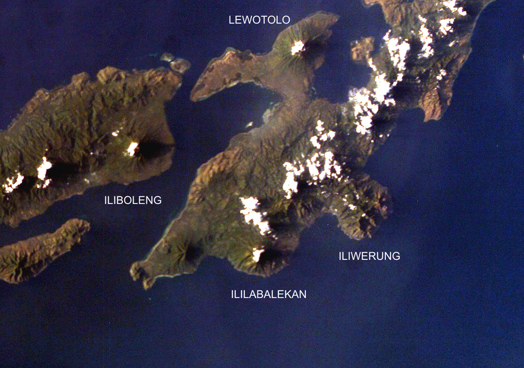
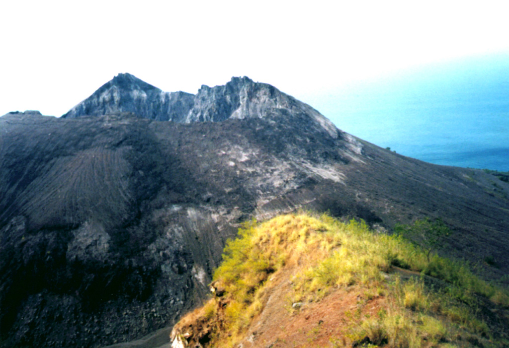
Four volcanoes are seen in this NASA International Space Station image (with north to the upper left) of Solor (lower left), Adonara (upper left), and Lembata (right) Islands. Ililabalekan volcano on SW Lembata (formerly Lomblen) Island is the only one of these without historical eruptions, although fumaroles are found near its summit. A satellitic cone was constructed on the SE flank of the steep-sided volcano, and four craters, one of which contains a lava dome and two small explosion pits, occur at the summit of Mount Labalekan
Based on visual and instrumental observations, the activity level of Mount IliWerung has been raised from level I (Normal) to level II (waspada) effective November 30, 2025 at 12:00 Central Indonesia Time (WITA).
Constructed on the southern rim of the Lerek caldera, Iliwerung forms a prominent south-facing peninsula on Lembata (formerly Lomblen) Island. Craters and lava domes have formed along N-S and NW-SE lines on the complex volcano; activity has been observed at vents from the summit to the submarine SE flank. The summit lava dome was formed during an eruption in 1870. In 1948 the Iligripe lava dome grew on the E flank at 120 m elevation. Beginning in 1973-74, when three ephemeral islands were formed, submarine eruptions began on the lower ESE flank at a vent named Hobal; several other eruptions have since taken place at this vent.
Sources : PVMBG. GVP.
Photos : PVMBG , GVP / Volcanological Survey of Indonesia , NASA International Space Station.
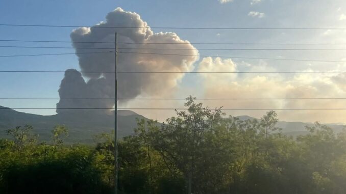
Colombia , Puracé – Los Coconucos volcanic chain:
Popayán, November 30, 2025, 8:40 a.m.
Regarding the monitoring of activity in the Los Coconucos volcanic chain, the Colombian Geological Survey (SGC), an agency under the Ministry of Mines and Energy, reports the following:
Since the Puracé volcano alert level was raised to orange and up to the date of this press release, seismic signals related to fluid movements, including tremors (TR) and long-period waves (LP), continue to be recorded. These signals indicate a continuous release of volcanic gases. Some of these emissions have been associated with small ash plumes in the atmosphere, the dispersion of which has been influenced by variations in wind patterns. Among these, the one recorded at 4:06 a.m. is particularly noteworthy.
On November 30, a continuous volcanic tremor signal was detected, with a seismic column reaching a height of over 500 meters above the summit of Mount Purace. However, due to adverse weather conditions, its maximum height was not visible on other installed cameras. The observed gas and ash plumes reached heights between 500 meters and 1.4 kilometers above the volcano’s summit. During this period, 23 alerts were issued to civil aviation authorities, including one at 4:15 a.m. this morning, corresponding to the continuous tremor signal. Very fine ashfall and strong sulfurous odors were also reported between 8:00 p.m. and 10:00 p.m. on November 29, originating from the village of Río Negro in the Paletará district, the Mina de Azufre, Agua Hirviendo, and Totoró road sectors, and the northern part of the city of Popayán.
With the orange alert still in effect, temporary fluctuations in volcanic activity are possible. This means that the level of activity may sometimes decrease compared to previous days or weeks, without necessarily indicating a return to stable activity. A reasonable amount of time is needed to assess all monitored parameters and determine trends that would indicate reliable stabilization before returning to a more stable level (yellow alert). Therefore, the recommendation to stay away from the volcano is reiterated.
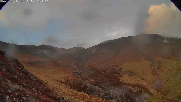
Image from the Piocollo camera located 2 km northeast of the Puracé volcano. A column of gas and fine ash is visible, with a minimum height estimated at 500 m above the summit of the Puracé volcano, although the total height is not visible on other cameras due to adverse weather conditions.
Given the above, the Geological Survey of Colombia (SGC) recommends not accessing the volcanic edifice and closely monitoring the evolution of activity by consulting special bulletins and other information disseminated through our official channels, as well as following the instructions of local and departmental authorities and the National Unit for Disaster Risk Management (UNGRD).
The volcanic activity level remains at ORANGE alert: volcano exhibiting significant variations in monitored parameters.
Source et photo : SGC.
La Martinique , Mount Pelée :
Weekly Report, Paris Institute of Earth Physics / Martinique Volcanological and Seismological Observatory
Saint-Pierre, November 28, 2025, 4:00 PM local time (GMT-4)
Volcanic activity decreased this week with 18 volcanic earthquakes observed.
Between November 21, 2025, 4:00 PM UTC and November 28, 2025, 4:00 PM UTC, the Martinique Volcanological and Seismological Observatory recorded:
15 shallow volcano-tectonic earthquakes. Among them, 2 had a magnitude (duration magnitude Md or local magnitude Mlv) greater than 0.5. The largest had a magnitude Mlv of 1.42. The others were of lower energy. These earthquakes originated from the well-known seismically active zones of Mount Pelée, located between 1.0 and 1.4 km below the volcano’s summit. Shallow volcano-tectonic seismicity is associated with micro-fracturing in the volcanic edifice linked to the global reactivation of the volcano observed since 2019.

Three shallow, low-energy hybrid earthquakes were recorded. They were located in the same area as the shallow volcano-tectonic earthquakes. Shallow hybrid earthquakes exhibit low-frequency enriched signals and are associated with the circulation of fluids (gases, hydrothermal fluids) within the volcanic edifice.
No earthquakes were felt by the population.
The previous week, the OVSM (Swiss Volcanic Observatory) had recorded 235 earthquakes of volcanic origin. As of November 28, 2025, and over the past four weeks, the OVSM has therefore observed a total of 439 volcanic earthquakes, an average of 109 to 110 earthquakes per week.
During phases of volcanic reactivation of volcanoes similar to Mount Pelée, it is common to observe seismic activity that varies in intensity and frequency. The probability of an eruptive activity in the short term remains low. However, considering all the observations collected since the end of 2018 and their nature, and based on recent observations from the OVSM-IPGP, we cannot rule out a change in the situation in the medium term (weeks, months).
The volcanic alert level, in accordance with the measures put in place by the authorities, is currently YELLOW: vigilance.
Source et photo : OVSM-IPGP.
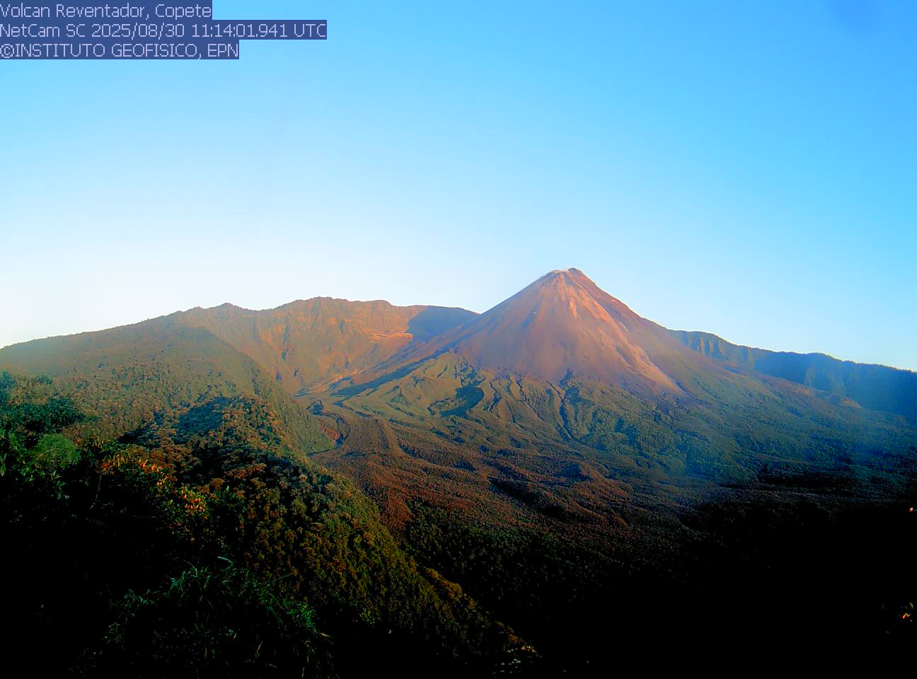
Ecuador , El Reventador :
REVENTADOR VOLCANO DAILY STATE REPORT, Sunday, November 30, 2025.
Geophysical Information Institute – EPN.
Surface Activity Level: High, Surface Trend: No Change
Internal Activity Level: Moderate, Internal Trend: No Change
From November 29, 2025, 11:00 AM to November 30, 2025, 11:00 AM:
Seismicity:
Below is the count of seismic events recorded at the reference station.
Explosion (EXP) 75
Long Period (LP) 8
Emission Tremor (TREMI) 5
Harmonic Tremor (TRARM) 3
Rainfall/Lahars:
No rainfall has been recorded in the volcano’s vicinity. **Heavy rainfall could remobilize accumulated material, generating mudflows and debris flows that would cascade down the volcano’s flanks and flow into nearby rivers.**
Emissions/Ash Plume:
Three gas and ash plumes were detected by the GOES-19 satellite system, reaching altitudes between 700 and 1,200 meters above the crater rim, drifting north-northeast, southeast, and east. The Washington VAAC issued three reports of gas and ash emissions reaching altitudes between 1,000 and 1,900 meters above the crater rim, drifting northwest, west-southwest, and southeast.
Other monitoring parameters:
The MIROVA MODIS satellite system recorded one thermal anomaly, MIROVA VIIRS recorded two, and the FIRMS satellite system recorded 23 in the last 24 hours.
Observation:
Since yesterday afternoon, the volcano has remained mostly covered in clouds.
Alert level – SGR: Orange
Source et photo : IGEPN
Nicaragua , Masaya :
Masaya Volcano Explosion: Ash Thrown Over Nearby Towns
The Santiago crater of the Masaya volcano experienced a sudden and audible explosion this Saturday, characterized by an intense emission of gas and ash. The event generated an ash column approximately 100 meters high, visible from several points within Masaya Volcano National Park.
While most of the ejected pyroclastic material fell directly back into the crater, the wind carried a thin layer of ash westward. Residents of towns such as Palo Solo, Ticuantepe, and parts of La Concepción reported hearing the explosion and observing volcanic dust falling. Surprisingly, the urban area of Masaya, despite its proximity, reported neither noise nor ashfall, highlighting the localized and limited nature of the event.
Experts have reiterated that this type of eruption is part of the normal dynamics of a constantly active volcano like Masaya. However, authorities are urging extreme caution, particularly for those living or traveling in areas affected by ashfall.
It is recommended to protect eyes and respiratory systems, avoid all outdoor exposure during ashfall, and follow official announcements. Currently, technical monitoring confirms that the volcano remains within normal activity parameters, with no major damage or imminent danger reported.
Source et photo : radio corporacion.com .