November 23 , 2025.
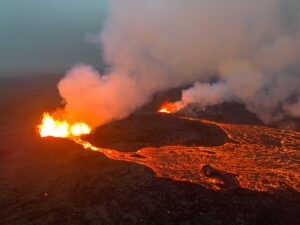
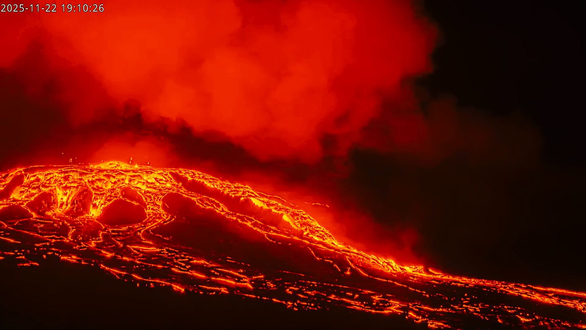
Hawaii , Kilauea :
HAWAIIAN VOLCANO OBSERVATORY DAILY UPDATE , U.S. Geological Survey
Saturday, November 22, 2025, 9:49 AM HST (Saturday, November 22, 2025, 19:49 UTC)
19°25’16 » N 155°17’13 » W,
Summit Elevation 4091 ft (1247 m)
Current Volcano Alert Level: WATCH
Current Aviation Color Code: ORANGE
Activity Summary:
Intermittent overflows began yesterday morning from both vents. Inflationary tilt is being recorded by summit tiltmeters. Models suggest that episode 37 will probably occur between today, November 22, and November 26 with highest probability between November 23-25.
Summit Observations:
Overflows began yesterday just after 9:30 a.m. HST, starting from the south vent, and continued intermittently throughout the day and overnight. There have been approximately 30 overflows since then, about 2/3 from the south vent and 1/3 from the north vent. Overflows alternated between the vents during the day yesterday, but were dominated by south vent overflows after dark and continuing this morning. One overflow event from the south vent produced a dome fountain starting at 1:30 a.m. HST, which was estimated to be 5-10 meters (15-30 feet) tall and lasted for approximately 25 minutes. This was associated with a minor increase in seismic intensity (RSAM) and brief decrease in tilt. Small tremor bursts associated with lava drain back were recorded along with low to moderate, continuous seismic tremor.
Inflation continues at the summit, but slowly. UWD recorded less than 1 microradian of inflationary tilt in the past 24 hours for a total of 20.6 microradians recorded since the end of episode 36 on November 9.
Plumes of gas are visible from both the south and north vents, and sulfur dioxide (SO2) gas emissions remain at eruption pause levels, typically between 1,200 and 1,500 tonnes per day.
Source et photo : HVO
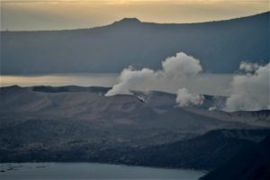
Indonesia , Semeru :
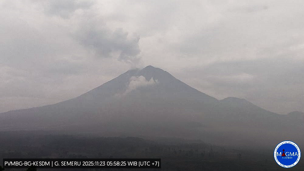
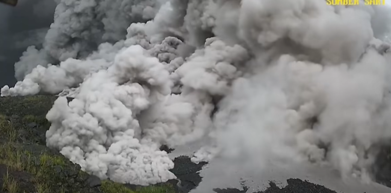
Mount Semeru erupted on Sunday, November 23, 2025, at 5:49 a.m. West Indonesian Time (WIB). An ash column was observed approximately 700 meters above the summit (about 4,376 meters above sea level). This thick, white to gray column extends southwestward. The eruption was recorded by a seismograph with a maximum amplitude of 22 mm and a duration of 125 seconds.
Seismicity observations:
36 eruption earthquakes with amplitudes ranging from 10 to 22 mm and durations of 88 to 146 seconds.
Two avalanche earthquakes with amplitudes between 2 and 4 mm and durations of 50 to 70 seconds.
Five emission earthquakes with amplitudes between 3 and 6 mm and a duration of 41 to 137 seconds.
Recommendations
1. All activity is prohibited in the southeastern sector of Besuk Kobokan, within 20 km of the summit (epicenter of the eruption). Beyond this distance, the public is advised to refrain from any activity within 500 meters of the Besuk Kobokan shoreline due to the risk of pyroclastic flow expansion and lahars.
2. All activity is prohibited within an 8 km radius of the crater/summit of Mount Semeru due to the risk of ejection of incandescent rocks.
3. Be vigilant regarding the risk of pyroclastic flows, lahar flows along rivers and valleys originating at the summit of Mount Semeru, particularly along Besuk Kobokan, Besuk Bang, Besuk Kembar and Besuk Sat, as well as the risk of lahars in the small tributary streams of Besuk Kobokan.
VOLCANO OBSERVATORY NOTICE FOR AVIATION – VONA
Issued : November 22 , 2025
Volcano : Semeru (263300)
Current Aviation Colour Code : ORANGE
Previous Aviation Colour Code : orange
Source : Semeru Volcano Observatory
Notice Number : 2025SMR3319
Volcano Location : S 08 deg 06 min 29 sec E 112 deg 55 min 12 sec
Area : East java, Indonesia
Summit Elevation : 11763 FT (3676 M)
Volcanic Activity Summary :
Eruption with volcanic ash cloud at 22h49 UTC (05h49 local).
Volcanic Cloud Height :
Best estimate of ash-cloud top is around 14003 FT (4376 M) above sea level or 2240 FT (700 M) above summit. May be higher than what can be observed clearly. Source of height data: ground observer.
Other Volcanic Cloud Information :
Ash cloud moving to southwest. Volcanic ash is observed to be white to gray. The intensity of volcanic ash is observed to be thick.
Remarks :
Eruption recorded on seismogram with maximum amplitude 22 mm and maximum duration 125 second.
Source : PVMBG
Photos : PVMBG, BMKG ( Capture d’écran )
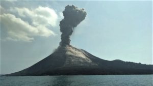
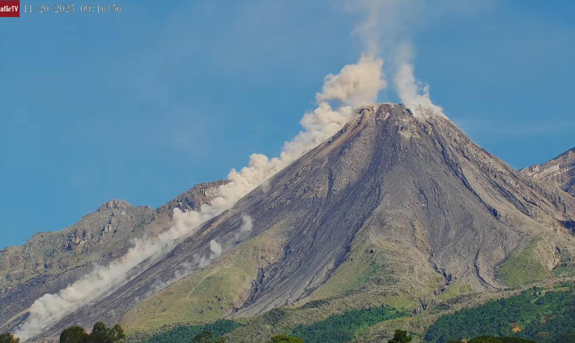
Guatemala , Santiaguito :
Atmospheric conditions: Clear skies
Wind: East
Precipitation: 0.2 mm
Activity:
Constant degassing is observed above the Caliente dome, reaching a height of 400 meters and dispersing westward. Low- to medium-intensity explosions have been recorded, with a column of gas and ash rising up to 800 meters above the dome and dispersing westward. During the night and early morning, incandescence can be observed on the dome itself and on its western and southwestern flanks, resulting from recurring avalanches cascading down these slopes.
The possibility of pyroclastic flows cannot be ruled out; therefore, it is essential to follow the recommendations of Special Bulletin BESAN-063-2025.
Given the presence of rain within the volcanic perimeter, low- to medium-intensity lahars may occur along the riverbeds on the southern flank (Nimá i Tambor, Cabello de Ángel, among others). Therefore, follow the recommendations of Special Bulletin BESAN-012-2025.
Source : Insivumeh.
Photo : Afar tv ( capture d’écran)
Ecuador , Sangay :
DAILY REPORT ON THE STATE OF SANGAY VOLCANO, Saturday, November 22, 2025.
Geophysical Information Institute – EPN.
Surface Activity Level: Moderate, Surface Trend: No Change
Internal Activity Level: Moderate, Internal Trend: No Change
Seismicity: From November 21, 2025, 11:00 AM to November 22, 2025, 11:00 AM:
Seismicity:
Below is the count of seismic events recorded at the reference station:
Explosion (EXP): 133
Rainfall/Lahars:
No rain has been recorded in the volcanic area. **Heavy rainfall could remobilize accumulated material, generating mudflows and debris flows that would cascade down the volcano’s flanks and flow into adjacent rivers.**
Emissions/Ash Column:
Due to weather conditions in the volcano’s region, no gas and/or ash emissions were observed via the monitoring camera system or the GOES-19 satellite system.
However, the Washington VAAC issued three reports of ash clouds reaching an altitude of 1,500 meters above the crater, drifting northwest and north.
Gas:
The MOUNTS satellite system recorded 86.30 tons of sulfur dioxide (SO₂) on November 21, 2025, at 1:14 p.m. local time.
Other monitoring parameters:
Over the past 24 hours, the FIRMS satellite system recorded 8 thermal anomalies and the MIROVA VIIRS (750) satellite system recorded 2.
Observation:
Due to weather conditions in the region, no incandescent material fallout was observed. At the time of writing, the volcano remained shrouded in clouds.
Alert level: Yellow
Source : IGEPN
Photo : Missael Rivadeneira / Volcan Sangay / FB.
Costa Rica , Poas :
OVSICORI-UNA Volcano Monitoring Weekly Bulletin, November 21, 2025
Latitude: 10.20°N;
Longitude: 84.23°W;
Altitude: 2,687 m
Current Activity Level: Alert
Tremor amplitude has been trending upward since the beginning of the month. On November 18, it reached its six-month peak. During some amplitude increases, the tremor becomes harmonic. Acoustic tremor remains almost nonexistent. The number of long-period events has decreased compared to last week, but remains generally high. Two nearby volcano-tectonic events were recorded. The geodetic network is recording subsidence of the volcano.
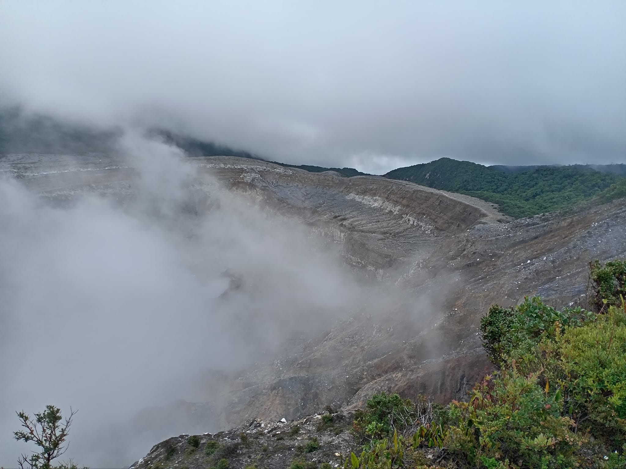
The Boca C MultiGAS station measured an average SO₂/CO₂ ratio of 0.8 ± 0.4 this week, similar to last week’s value (0.8 ± 0.2). The H₂S/SO₂ ratio increased slightly to 1.3 ± 0.1. The ExpoGAS station at the Visitor Lookout measured a maximum SO₂ concentration of 1.6 ppm this week, which is relatively low. DOAS stations detected an SO₂ flux of 249 ± 91 t/d, similar to the previous week’s (253 ± 51 t/d).
Source et photo : Ovsicori.