November 4 , 2025.
Hawaii , Kilauea :
HAWAIIAN VOLCANO OBSERVATORY DAILY UPDATE , U.S. Geological Survey
Monday, November 3, 2025, 8:37 AM HST (Monday, November 3, 2025, 18:37 UTC)
19°25’16 » N 155°17’13 » W,
Summit Elevation 4091 ft (1247 m)
Current Volcano Alert Level: WATCH
Current Aviation Color Code: ORANGE
During the lapse in appropriations, the USGS Hawaiian Volcano Observatory (HVO) continues to maintain monitoring networks and issue updates and notifications of volcanic activity via the Hazard Notification Service. Volcano monitoring data will continue to be available on the HVO website. Static website content will not be updated until further notice and information may become outdated over time.
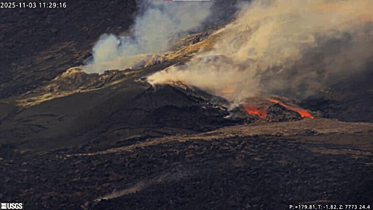
Activity Summary:
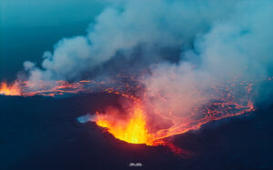
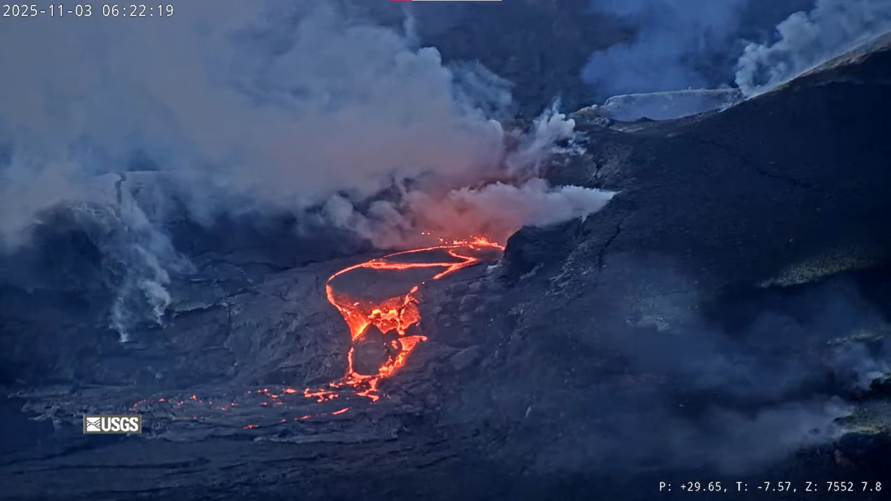
Episode 35 of the ongoing Halemaʻumaʻu eruption ended on October 18 after 7.5 hours of continuous lava fountaining. Both vents continue to exhibit strong incandescence along with minor spattering overnight. The north vent also exhibited frequent lava overflows. Kīlauea summit inflation was relatively minor in the last 24 hours; however, repeated overflows from the north vent indicate the start of episode 36 is close. Models suggest a likely forecast window of November 4–8 for episode 36 with November 5-7 most probable.
Summit Observations:
The north and south vents had strong glow and minor periods of spattering overnight and into the early morning. The north vent also had frequent lava overflow periods beginning at 12:45 am HST and continuing into the morning with a total of 11 at this time. Magma is currently filling the north vent and drainback events have been small this morning. (Note: The infrared filters were turned off on the V2 and V3 making them appear much brighter and white in color.)
Vent Start time End time Duration (hr:mm)
1 North 10/31/25 9:25 PM 10/31/25 9:28 PM 0:03
2 North 11/3/25 12:46 AM 11/3/25 12:53 AM 0:07
3 North 11/3/25 1:39 AM 11/3/25 1:42 AM 0:03
3 North 11/3/25 1:59 AM 11/3/25 2:02 AM 0:03
4 North 11/3/25 2:49 AM 11/3/25 2:55 AM 0:06
5 North 11/3/25 3:16 AM 11/3/25 3:32 AM 0:16
6 North 11/3/25 3:46 AM 11/3/25 4:00 AM 0:14
7 North 11/3/25 4:46 AM 11/3/25 4:50 AM 0:04
8 North 11/3/25 5:11 AM 11/3/25 5:18 AM 0:07
9 North 11/3/25 5:40 AM 11/3/25 5:55 AM 0:15
10 North 11/3/25 6:10 AM 11/3/25 6:57 AM 0:47
11 North 11/3/25 7:28 AM 11/3/25 7:35 AM 0:07
12 North 11/3/25 8:21 AM 11/3/25 8:31 AM 0:10
The summit continues to inflate. The Uēkahuna tiltmeter (UWD) has recorded approximately 0.9 microradian of inflationary tilt over the past 24 hours and 24.2 microradians of inflationary tilt since the end of episode 35. Tremor patterns consisted of continuous tremor with occasional bursts of stronger tremor signal overnight. Tremor is not showing the strong correlation with lava overflows and drainbacks characteristic of normal gas pistoning.
Plumes of gas continue from both vents this morning and sulfur dioxide (SO2) gas emissions remain at background levels, typically between 1,200 and 1,500 tonnes per day.
Source et photo : HVO
New Zealand , White Island :
Minor ash emission confirmed following short-lived eruptions. Volcanic Alert Level Remains at Level 3 and Aviation Colour Code remains Orange.
Published: Tue Nov 4 2025 3:00 PM
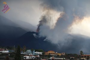
An observation flight yesterday afternoon has confirmed minor ash emissions are occurring at Whakaari/White Island but are unlikely to have reached the mainland. Two small, low energy eruptions occurred on 30 October. The Volcanic Alert Level remains at Level 3 and the Aviation Colour Code remains Orange.
Since our observations of weak eruptions at the end of last week, MetService detected volcanic ash in satellite imagery since Sunday 2 November. Sulphur dioxide (SO2) was also detected by satellite imagery on 30 October and 2 November.
The observation flight confirmed the ash plume was rising to 400 – 500 m above sea level and was blown to the southeast for 5 to 8 km. Based on our modelling, the observed activity is unlikely to impact the mainland with ashfall. As a result of the continued minor ashfall on the island, deposits of fine ash have accumulated on the main crater floor. Vent temperatures are around 250 ºC and have increased with respect to the previous two measurements prior to the most recent activity. However, temperatures are still well below the maximum of around 500 ºC observed earlier this year.
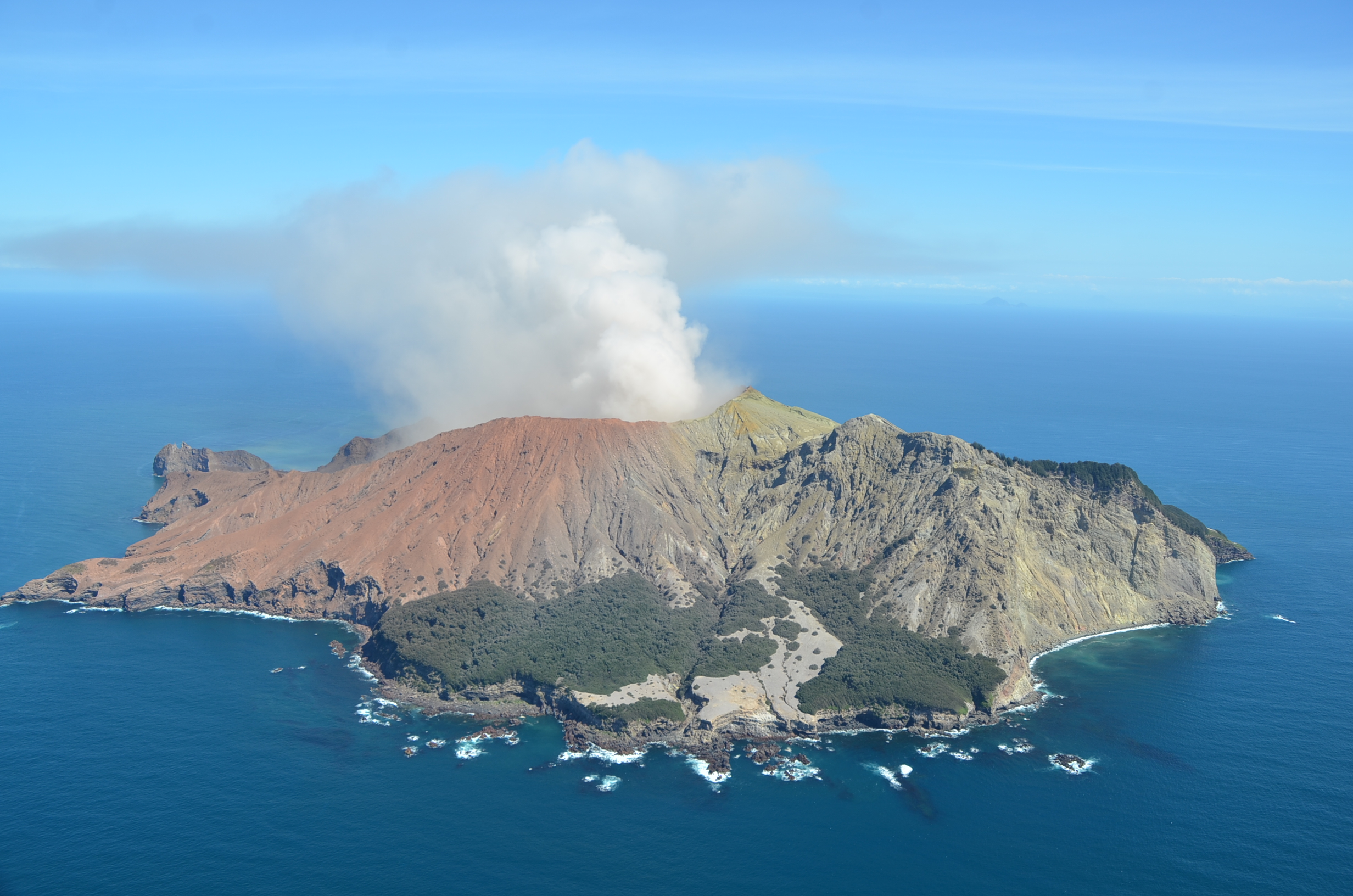
Image from observation flight from the north on 3 November 2025, showing the steam and gas plume, containing minor amounts of volcanic
Based on the recent observations, the Volcanic Alert Level remains at level 3 (minor volcanic eruption) and the Aviation Colour Code remains Orange. These levels acknowledge the predominant level of activity but also reflect the degree of uncertainty about volcanic activity due to the current lack of real-time monitoring data from the island.
To further assess the status of the volcano we will plan a gas flight when conditions are suitable. Earth Sciences NZ Volcano Monitoring Group and National Geohazards Monitoring Centre will continue to closely monitor Whakaari/White Island for any changes in activity. Without sensors on the Island, our monitoring continues to rely on remote cameras, satellite imagery, and periodic observation and gas flights to monitor Whakaari/White Island. We will provide further updates when information becomes available.
Source : Geonet / Yannik Behr / Duty Volcanologist
Photo : Craig Miller
Kamchatka , Krasheninnikov :
VOLCANO OBSERVATORY NOTICE FOR AVIATION (VONA)
Issued: 20251103/2157Z
Volcano: Krasheninnikov (CAVW #300190)
Current aviation colour code: ORANGE
Previous aviation colour code: orange
Source: KVERT
Notice Number: 2025-128
Volcano Location: N 54 deg 35 min E 160 deg 16 min
Area: Kamchatka, Russia
Summit Elevation: 1856 m (6087.68 ft)
Volcanic Activity Summary:
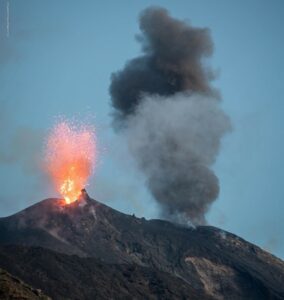
Moderate emissions of ash from the volcano continues. The explosions sent ash up to 2.4 km a.s.l., and an ash plume is extending for 80 km to the east-southeast of the volcano.
The explosive-effusive eruption of the volcano continues. The danger of ash explosions up to 6 km (19,700 ft) a.s.l. remains. Ongoing activity could affect low-flying aircraft.
Volcanic cloud height:
2400 m (7872 ft) AMSL Time and method of ash plume/cloud height determination: 20251103/2120Z – Himawari-9 14m15
Other volcanic cloud information:
Distance of ash plume/cloud of the volcano: 80 km (50 mi)
Direction of drift of ash plume/cloud of the volcano: ESE / azimuth 117 deg
Time and method of ash plume/cloud determination: 20251103/2120Z – Himawari-9 14m15
Remarks:
The first historical eruption of the volcano began on 02 August, 2025. The explosive-effusive eruption of the volcano continues. The previous effusive eruption of the volcano occurred 400-600 years ago.
Source : Kvert.
Photo : Yuri Doubik (Institute of Volcanology, Petropavlovsk), via GVP.
United States , Yellowstone :
YELLOWSTONE VOLCANO OBSERVATORY MONTHLY UPDATE , U.S. Geological Survey
Monday, November 3, 2025, 2:13 PM MST (Monday, November 3, 2025, 21:13 UTC)
44°25’48 » N 110°40’12 » W,
Summit Elevation 9203 ft (2805 m)
Current Volcano Alert Level: NORMAL
Current Aviation Color Code: GREEN
Summary
Yellowstone Caldera activity remains at background levels, with 180 located earthquakes in October (largest = M3.7). Deformation measurements indicate that the annual summertime pause in long-term caldera subsidence has ended, and subsidence has resumed.
Recent Work and News
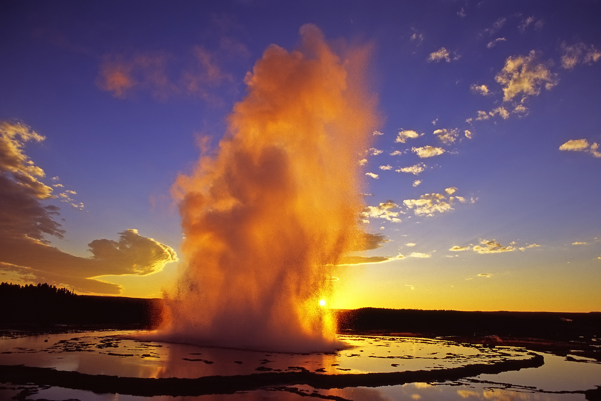
Minor eruptions of Steamboat Geyser in Norris Geyser Basin remain sporadic, indicating that a major eruption is unlikely anytime soon. There have only been 2 major eruptions of the geyser so far during 2025, and the period of frequent activity that started in 2018 has probably ended. Valentine and Guardian Geysers in Norris Geyser Basin continued intermit eruptions through mid-October.
Seismicity
During October 2025, the University of Utah Seismograph Stations, responsible for the operation and analysis of the Yellowstone Seismic Network, located 180 earthquakes in the Yellowstone National Park region. The largest event of the month was a minor earthquake of magnitude 3.7 located about 14 miles south-southwest of Mammoth Hot Springs in Yellowstone National Park on October 28 at 7:22 a.m. MDT.
October seismicity in Yellowstone was marked by four swarms:
1. A swarm that started approximately 14 miles south-southwest of Mammoth Hot Springs in Yellowstone National Park in late September continued with ongoing seismicity in early to mid October, adding 15 earthquakes to the sequence. The largest earthquake of the swarm during October was a magnitude 1.7 on October 8 at 10:06 p.m. MDT.
2. A swarm of 23 earthquakes took place approximately 4 miles southwest of West Thumb, in Yellowstone National Park, on October 15. The largest earthquake in the sequence was a magnitude 1.9 on October 15 at 4:15 a.m. MDT.
3. A swarm of 12 earthquakes occurred approximately 6 miles north of West Yellowstone, Montana, during October 28–30. The largest earthquake in the sequence was a magnitude 2.0 on October 29 at 1:25 a.m. MDT.
4. A second swarm of 42 earthquakes in the region of swarm #1 (above), approximately 14 miles south-southwest of Mammoth Hot Springs in Yellowstone National Park, took pace during October 28–31. The largest swarm earthquake is also the largest of October (described above).
Earthquake activity in Yellowstone remains at background levels.
Ground Deformation
Continuous GPS stations in Yellowstone Caldera recorded the end of the seasonal deformation signal, which is related to snowmelt and groundwater conditions. Starting in mid-October, the summertime pause in subsidence or slight uplift ended, and long-term subsidence, which has been ongoing since 2015, resumed. Deformation in the area of Norris Geyser Basin also recorded the end of the seasonal uplift signal.
Source et photo : YVO
Indonesia , Kerinci :
Increased seismic activity at Mount Kerinci, in the provinces of West Sumatra and Jambi, on November 3, 2025.
Mount Kerinci is located in the districts of Kerinci (Jambi) and South Solok (West Sumatra). Its summit reaches an altitude of 3,805 meters, at coordinates -1.697°N, 101.264°E.
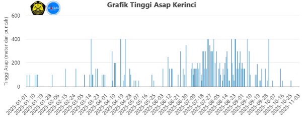
From October 16 to November 2, 2025, visual observations showed that Mount Kerinci was clearly visible until it became shrouded in fog. In clear weather, a faint to moderate white plume of smoke escaped from the main crater and rose to about 50 meters above the summit. The color of this smoke indicates a predominance of water vapor, with no rock or ash ejected. The seismic activity recorded during this period included: 265 emission earthquakes, 894 low-frequency earthquakes, 1,455 hybrid/multiphase earthquakes, 14 shallow volcanic earthquakes, 6 deep volcanic earthquakes, 1 local tectonic earthquake, 39 distant tectonic earthquakes and 1 flood-related earthquake.
On November 3, 2025, starting at 5:00 a.m. West Indonesian Time (WIB), an increase in seismicity was observed, including deep and shallow volcanic earthquakes. By 10:00 a.m., 46 shallow volcanic earthquakes had been recorded, with maximum amplitudes ranging from 0.4 to 23.9 mm and durations from 9.1 to 23.9 seconds. Thirteen deep volcanic earthquakes were recorded, with maximum amplitudes ranging from 0.8 to 10.3 mm and durations from 9.2 to 20.1 seconds.
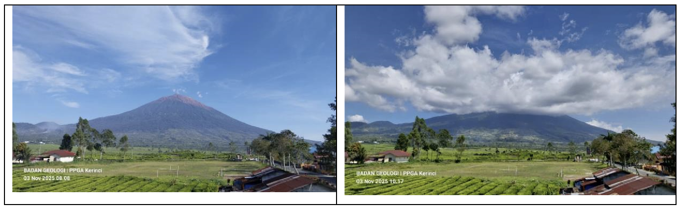
Visual observations at 8:08 a.m. on November 3 revealed no gas eruptions from the summit crater, while at 10:17 a.m. local time, the crater/summit was shrouded in mist. The RSAM graph, which reflects seismic energy, fluctuated before stabilizing until the end of the observation period. The calculated S-P values for deep volcanic earthquakes remained stable at an average of 0.7 seconds, with no apparent shortening indicating fluid migration to shallower depths. The increase in these two types of volcanic earthquakes is likely due to gas-dominated fluid activity at relatively significant depths. However, more intensive monitoring will be implemented to anticipate a more significant increase in the number of deep and shallow volcanic earthquakes, particularly if they are accompanied by shaking and/or visual changes/anomalies.
The current activity level of Mount Kerinci is Level II (Waspada). The public and visitors/tourists are advised to avoid approaching the summit crater or engaging in any activities within a 3 km radius. The main potential hazard of Mount Kerinci is the accumulation of volcanic gases in the crater/at the summit, which could lead to an explosive eruption, producing incandescent rocks and significant ashfall. Lahar flows are possible along rivers originating in the summit area. This risk is increased during periods of heavy rainfall.
Source et photo : PVMBG.