October 19 , 2025.
Hawaii , Kilauea :
HAWAIIAN VOLCANO OBSERVATORY DAILY UPDATE , U.S. Geological Survey
Saturday, October 18, 2025, 10:34 AM HST (Saturday, October 18, 2025, 20:34 UTC)
19°25’16 » N 155°17’13 » W,
Summit Elevation 4091 ft (1247 m)
Current Volcano Alert Level: WATCH
Current Aviation Color Code: ORANGE
During the lapse in appropriations, the USGS Hawaiian Volcano Observatory (HVO) continues to maintain monitoring networks and issue updates and notifications of volcanic activity via the Hazard Notification Service. Volcano monitoring data will continue to be available on the HVO website. Static website content will not be updated until further notice and information may become outdated over time.
Activity Summary:
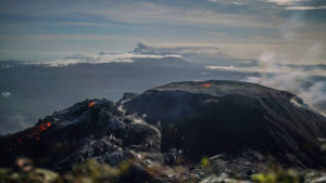
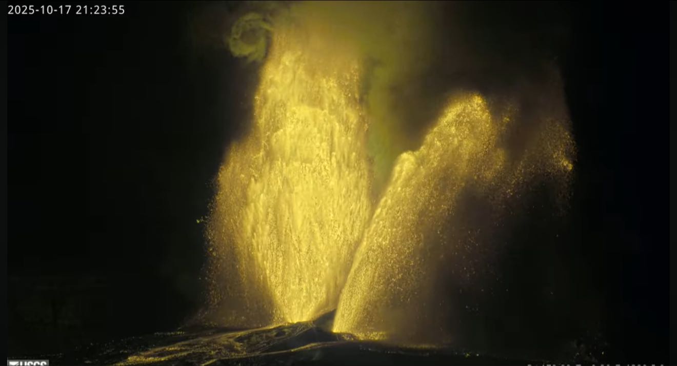
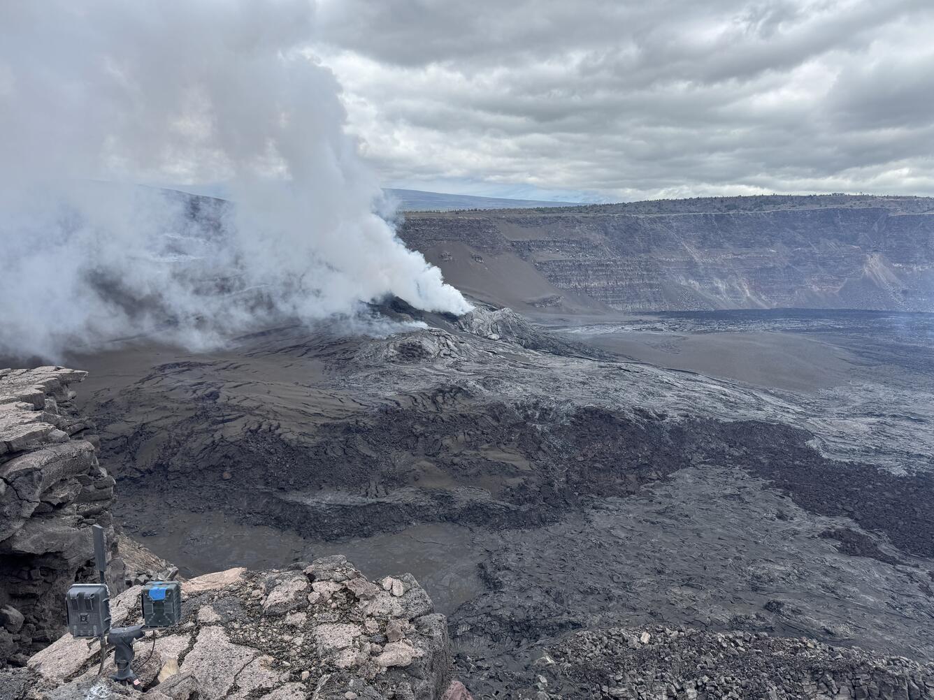
Episode 35 of the ongoing Halemaʻumaʻu eruption ended abruptly at 3:32 a.m. HST this morning, October 18, after 7.5 hours of continuous fountaining. Vent areas and lava flows may continue to exhibit slow movement and/or incandescence as they cool and solidify over the coming days. Kīlauea summit inflation resumed following the end of episode 35, indicating that another fountaining episode is possible, but likely at least two weeks away.
Summit Observations:
Episode 35 fountains began at approximately 8:05 p.m. HST on October 17 from the north vent. The north vent fountains grew rapidly to heights of 500 feet (150 meters) when the south vent began erupting at 8:50 p.m. The south vent fountains also grew rapidly and within 20 minutes had equaled the north vent fountains in size. By 9:30 p.m. fountain heights from both vents exceeded 1,000 feet (300 meters) and continued to grow. By 10:15 p.m., south vent fountains reached heights of nearly 1,500 feet (460 meters) and north vent fountains reached heights of about 1100 feet (330 meters). These were the highest single fountain and highest pair of fountains seen during this eruption so far. The south vent stopped erupting at approximately 3:29 a.m. followed by the north vent at 3:32 a.m., marking the end of episode 35.
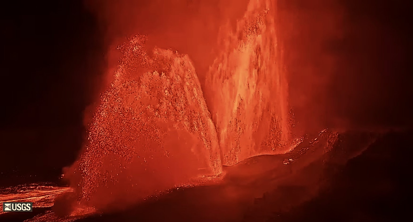
Episode 35 fountains produced an estimated 13 million cubic yards (10 million cubic meters) of lava. The combined average eruption rate was over 500 cubic yards per second (400 cubic meters per second) from the dual fountains. Lava flows from the fountains covered about two thirds of the floor of Halemaʻumaʻu crater. Vent areas and lava flows may continue to exhibit slow movement and/or incandescence as they cool and solidify over the coming days. Several secondary lava flows formed after the eruption ended as agglutinated tephra on the slopes of the cone remobilized and flowed downhill making small ʻāʻā-like flows.
Seismic tremor increased significantly, and summit tilt switched from inflation to deflation last night at about the same time that sustained fountaining began. The Uēkahuna tiltmeter (UWD) recorded about 24 microradians of inflationary tilt between the end of episode 34 and the start of episode 35. UWD recorded over 28 microradians of deflationary tilit during episode 35. The end of the eruption was coincident with a rapid change from deflation to inflation at the summit and a decrease in seismic tremor intensity. UWD has recorded about 2 microradians of inflationary tilt since the end of episode 35.
The plume of volcanic gas above episode 35 fountains extended to over 16,000 feet (5,000 meters) above ground level. [Note: this update was originally published with a typo that incorrectly stated « 16,0000 feet » instead of « 16,000 feet ».] Volcanic gas emissions greatly decreased this morning after fountaining ended and are currently estimated to be at or near normal noneruptive levels of 1,200-1,500 tonnes per day of sulfur dioxide.
The Hawaiʻi County Civil Defense Agency reported that tephra fell on Highway 11 southwest of the vents. Fine ash and Peleʻs hair can be carried long distances and may have impacted a broad area of Kaʻu along the southern and southwestern parts of Mauna Loa. Strands of volcanic glass known as Pele’s hair are present throughout the summit area of Hawaiʻi Volcanoes National Park and surrounding communities and can be remobilized by wind even after lava fountaining has ceased.
Episode 35 was preceded by a series of 35 lava overflow-drainback events at the south vent beginning on October 16 at 7:35 a.m. HST and continuous lava overflows from the north vent beginning on October 17 at 7:28 p.m.
Source : HVO
Photos : HVO , USGS / M. Patrick.
Indonesia , Ibu :
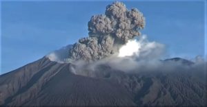
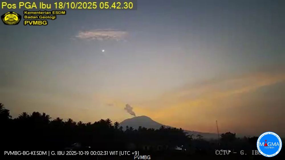
Mount Ibu erupted on Sunday, October 19, 2025, at 10:09 a.m. (local time). An ash column was observed about 600 m above the summit (about 1,925 m above sea level). The ash column was gray and of strong intensity, oriented northwest. This eruption was recorded by seismograph with a maximum amplitude of 10 mm and a duration of 66 seconds.
Seismic Observations
88 eruption earthquakes with amplitudes ranging from 15 to 28 mm and durations ranging from 32 to 76 seconds.
3 emission earthquakes with amplitudes ranging from 4 to 20 mm and durations ranging from 33 to 43 seconds.
11 harmonic tremors with amplitudes ranging from 2 to 20 mm and durations ranging from 21 to 85 seconds.
97 low-frequency earthquakes with amplitudes ranging from 2 to 10 mm and durations ranging from 17 to 29 seconds.
217 shallow volcanic earthquakes with amplitudes ranging from 2 to 6 mm and durations ranging from 7 to 22 seconds.
5 deep volcanic earthquakes with amplitudes ranging from 4 to 15 mm and durations ranging from 15 to 22 seconds.
Four local tectonic earthquakes with amplitudes of 2 to 8 mm and durations of 24 to 36 seconds.
Nine distant tectonic earthquakes with amplitudes of 2 to 20 mm and durations of 35 to 75 seconds.
Recommendations
Residents of Mount Ibu and visitors/tourists are advised to avoid all activities within a 2 km radius and a 3.5 km sectoral extension towards the crater opening, in the northern part of the active crater of Mount Ibu.
In the event of ashfall, people engaging in outdoor activities are advised to wear a mask and protective eyewear.
Source et photo : PVMBG.
Colombia , Galeras :
San Juan de Pasto, October 14, 2025, 2:40 p.m.
Regarding the monitoring of the activity of the Galeras Volcano, the Colombian Geological Survey (SGC), an entity affiliated with the Ministry of Mines and Energy, reports that:
During the week of October 7 to 13, 2025, and compared to the previous week, the main variations in the monitored parameters were:
● An increase in seismic occurrence and energy release was recorded, maintaining the predominance of seismicity associated with rock fracturing in the volcanic system.
● The localized earthquakes showed multiple sources in various sectors of the volcanic complex, with a maximum magnitude of 1.4. One of the recurring sources was located close to the main crater, less than 1.0 km away, at a depth of less than 3.1 km from the Galeras summit (4,200 m above sea level) and with a magnitude of less than 0.5. Another group of events was located to the northeast of the volcanic complex, at distances of up to 12 km, at depths between 6.6 and 8.7 km and with a maximum magnitude of 1.4.
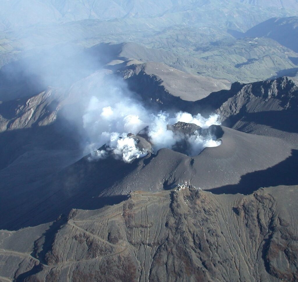
● Low gas emissions were observed, mainly from the fumarole fields of El Paisita, to the north, and Las Chavas, to the west of the active cone. The plumes were small, white, and exhibited variable dispersion depending on wind direction and speed.
● Other volcanic monitoring parameters showed stability. In light of the above, the SGC recommends closely monitoring the situation through weekly bulletins and other information published through our official channels, as well as instructions from local and departmental authorities and the National Disaster Risk Management Unit (UNGRD).
Volcanic activity remains on yellow alert: active volcano with changes in the baseline behavior of monitored parameters and other manifestations.
Source et photo : SGC.
Ecuador , El Reventador :
Special Volcanic Report – El Reventador
Summary
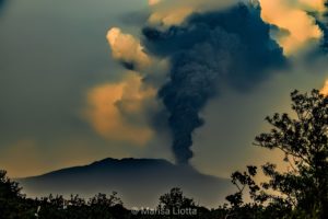
On October 12, 2025, at 6:23 p.m. LT, a pyroclastic flow was recorded on the eastern flank of El Reventador Volcano. This event generated an ash column that reached 1,500 meters above the crater and moved south-southwest. The ash cloud then reached a height of 2,300 meters. Following this increased activity, continuous emissions of gases with varying ash content continued this morning, October 13, reaching 800 meters above the crater and moving southwest of the volcano. Additionally, due to the activity recorded last night (pyroclastic flows and ash cloud) and citizen reports, a slight ash fall was confirmed in the areas of Hostería El Reventador, Salado-San Carlos Highway and Piedra Fina, in the Chaco canton, Napo province.
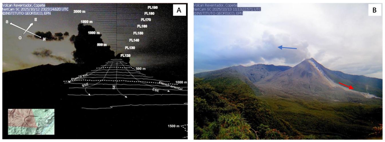
Pyroclastic cloud or burning cloud descending from the eastern flank of the volcano on the night of October 12, 2025, at 6:23 p.m. LT. B) Photograph of the El Reventador volcano on October 13, 2025. On the right, in beige (red arrow), we can see the deposit left by the pyroclastic flow of October 12, 2025, and the constant release of gas from the crater in a southwesterly direction (blue arrow).
At present, the formation of new pyroclastic flows from the volcano’s flanks cannot be ruled out; therefore, it is recommended not to approach it. Furthermore, preventive measures should be taken regarding ashfall. The accumulation of loose material generated by pyroclastic flows can be easily remobilized by rain, leading to the formation of new lahars. In this case, it is important to stay away from the volcano’s springs (Reventador, Marker, and Azuela rivers).
The IG-EPN remains vigilant and will promptly report any increase in volcanic activity.
Seismicity
The volcano’s seismic activity is characterized by 50 to 70 small explosions per day. The number of explosions has decreased slightly since October 3, 2025, giving way to the appearance of short-term tremor episodes.
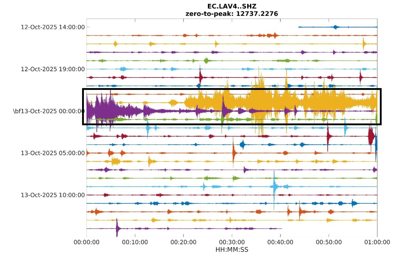
At 18:23 On October 12, at 14:00 LT (local time), a volcanic tremor signal of variable amplitude began to form and lasted for 50 minutes. This seismic signal is visible in Figure 1, inside the black box. Figure 1 represents the seismicity from October 12 at 14:00 LT to October 13 at the same time. Small explosions typical of the El Reventador volcano are also observed.
Source et photos : IGEPN
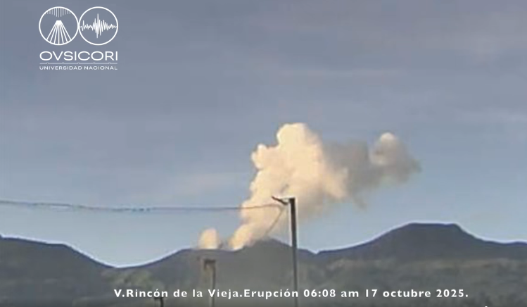
Costa Rica , Rincon de la Vieja :
Latitude: 10.83°N;
Longitude: 85.34°W;
Altitude: 1,916 m.
Current Activity Level: Alert.
Five small eruptions were recorded this week. On Friday, October 17, three eruptions were recorded in the morning: the first at 6:06 AM, the second at 7:03 AM, and the third at 8:26 AM. These eruptions did not generate lahars, but lifted a column of sediment from the crater lake, which fell back into the crater. The amplitude and frequency of ground tremor varied this week. This shaking was generally stronger than in previous weeks. Brief pulses of larger tremor were also observed. However, prior to these eruptions, the amplitude of the tremor decreased starting at 5:00 PM. On October 16, in the morning after the eruptions, the tremor became banded.
Long-period, « tornillos » events and sporadic earthquakes near the crater continued to occur. Geodetic observations show contraction of the base and displacement of the summit towards the crater. This week, DOAS stations recorded a SO2 flux of 51 ± 10 t/d, a value similar to that of the previous week (56 ± 28 t/d). The MultiGAS station measured low SO2 concentrations this week (< 1 ppm), H2S/SO2 ratios close to about 0.9, and high CO2/SO2 ratios (> 10). The last detection of SO2 in the atmosphere by satellite measurements dates back to September 7.
Source et photo : Ovsicori.