October 16 , 2025.
Indonesia , Lewotobi Laki-laki :
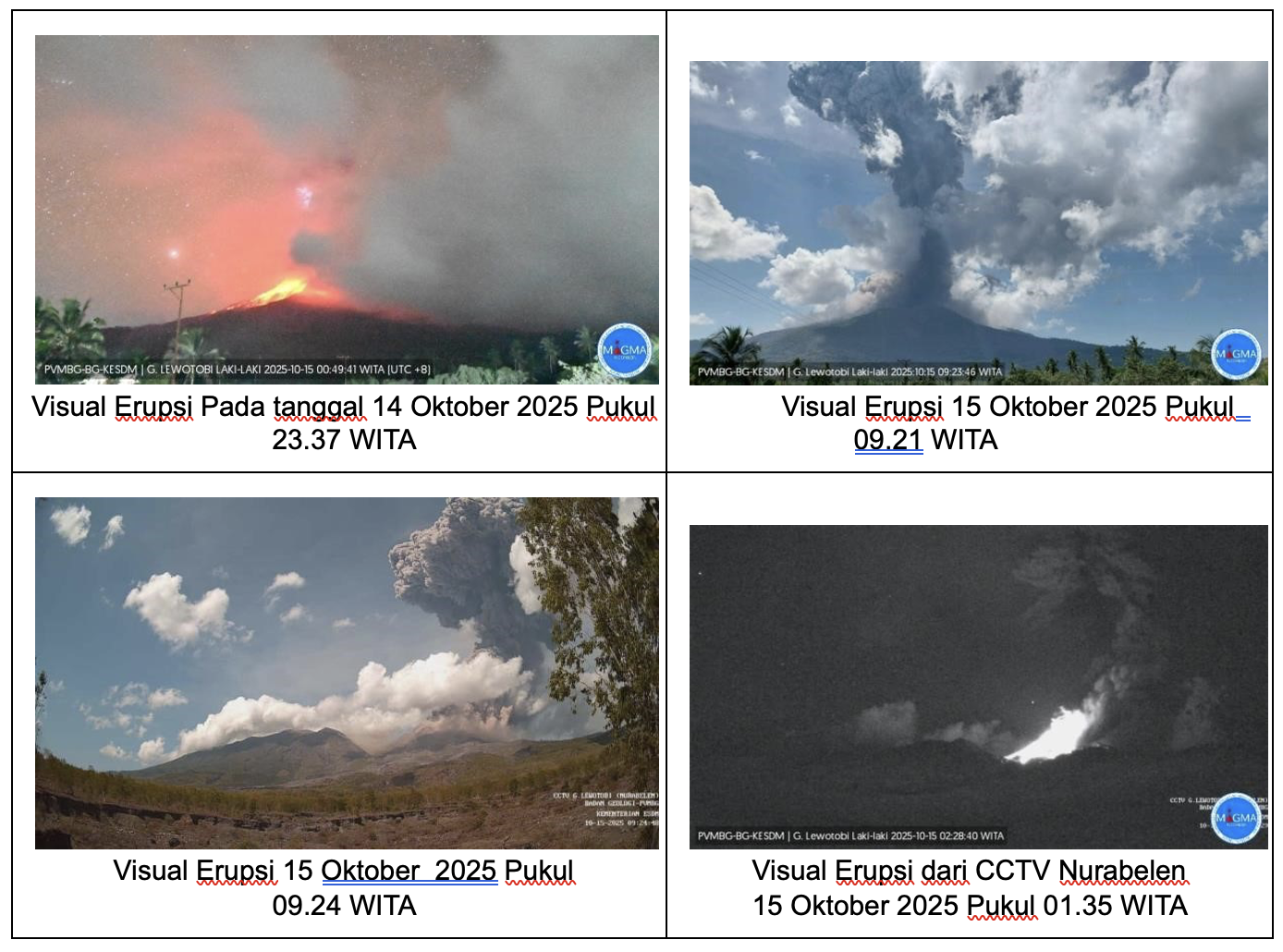
LEWOTOBI LAKI-LAKI, ACTIVITY LEVEL IV (AWAS) ON 15 October 2025.
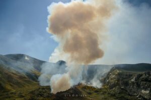
The volcano was clearly visible until it was covered by moderate fog. White smoke of fine, moderate to thick intensity was observed from the main crater, approximately 300 meters above the summit. An eruption occurred at an altitude of 8,000 to 10,000 meters above the summit, with a gray ash column. Avalanches occurred, but their distance and direction were not visually observed.
A significant increase in deep volcanic earthquake (VA) activity was observed on 14 October 2025 at 7:00 PM (local time). A few hours earlier, two large-amplitude VA earthquakes had been recorded. Therefore, the activity of Mount Lewotobi was raised to Level IV (AWAS) on October 14, 2025 at 21:30 WITA (Central Indonesia Time).
The first eruption occurred the same day at 23:37 WITA, preceded by 45 earthquakes of varying magnitude and amplitude (including two of higher magnitude) and a higher magnitude local tectonic earthquake (LT). This eruption ejected material in all directions, forming an ash column reaching approximately 9,000 meters in height, although inclinometric data indicate a downward trend.
The second eruption occurred on October 15, 2025, at 01:35 WITA, accompanied by a deafening rumble that could be heard as far away as Lewolaga, approximately 30 km from the epicenter. It was also accompanied by volcanic lightning and produced an ash column approximately 10,000 meters in height.
In the six hours preceding the third eruption, a further increase in seismic activity at Mount Lewotobi was recorded, with 33 events. This third eruption produced an ash column reaching approximately 8,000 meters.
The seismic data from October 14th and 15th, at 12:00 (local time), included:
5 eruption earthquakes,
6 avalanche earthquakes,
5 emission earthquakes,
30 nonharmonic tremors,
5 low-frequency earthquakes,
1 shallow volcanic earthquake,
156 deep volcanic earthquakes,
8 local tectonic earthquakes,
8 distant tectonic earthquakes,
1 flood earthquake.
Visually and seismically, Mount Lewotobi’s activity remains high, although tiltmeter monitoring of deformation data indicates a deflationary trend. Meanwhile, Global Navigation Satellite System (GNSS) data for the same period show an increase in the vertical component (deflation). This condition indicates a migration of magma from deep to shallow depths, indicating that internal pressure is still exerted, causing the volcano to expand. Therefore, the risk of eruption remains present.
Based on visual and instrumental analyses, the activity of Lewotobi Laki-laki volcano remains high, with its activity level remaining at Level IV (AWAS).
Source : PVMBG
Photos : Severe Weather & Natural Disasters , Capture d’écran 15/10/2025 via FB , PVMBG .
Colombia , Chiles/ Cerro Negro :
San Juan de Pasto, October 14, 2025, 2:45 p.m.
Regarding the monitoring of the activity of the Chiles-Cerro Negro Volcanic Complex (CVCCN), the Colombian Geological Survey (SGC), an entity affiliated with the Ministry of Mines and Energy,
reports that:
From October 7 to 13, 2025, and compared to the previous week, the main variations in the monitored parameters were:
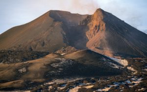
● Seismic activity and energy release increased significantly, particularly due to the predominance of seismicity associated with rock fracturing within the volcanic edifice. Recording of earthquakes related to fluid dynamics continued.
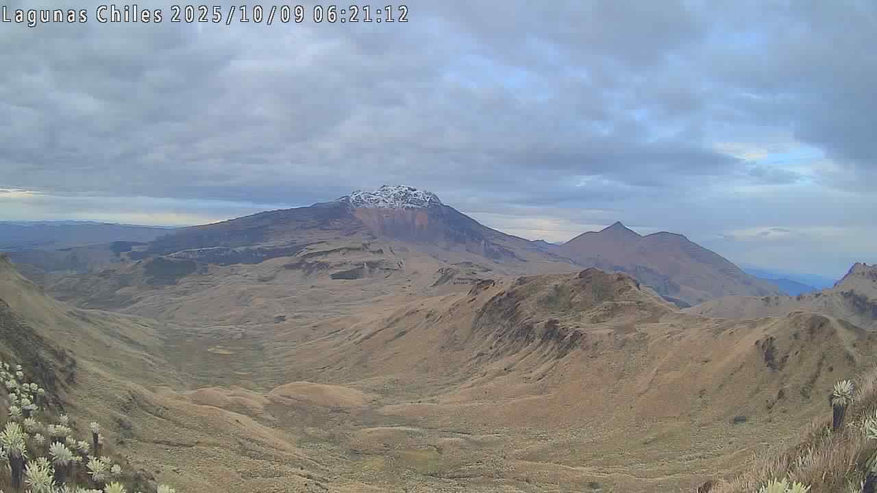
● Most of the earthquakes were concentrated at the summit of Chiles Volcano and on its western and southern flanks, within a band of approximately 3 km, at depths between 2 and 5.5 km from the summit (4,700 m above sea level). During this period, 15 earthquakes with magnitudes between 2 and 3.4 were located. The largest occurred on October 7, 2025, at 2:07 a.m. It was felt by residents of the Chiles Indigenous Reserve and was located on the western flank of the volcano, at a depth of 3.7 km.
● Analysis of information obtained from satellite sensors and ground stations continues to indicate variations related to deformation processes in the volcanic zone.
Based on the assessment and correlation of monitored parameters, the SGC recommends closely monitoring their developments through weekly bulletins and other information published through our official channels, as well as instructions from local and departmental authorities and the National Disaster Risk Management Unit (UNGRD).
Volcanic activity remains on yellow alert: active volcano with changes in the baseline behavior of monitored parameters and other manifestations.
Source et photo : SGC.
Hawaii , Kilauea :
HAWAIIAN VOLCANO OBSERVATORY DAILY UPDATE. U.S. Geological Survey
Wednesday, October 15, 2025, 8:36 AM HST (Wednesday, October 15, 2025, 18:36 UTC)
19°25’16 » N 155°17’13 » W,
Summit Elevation 4091 ft (1247 m)
Current Volcano Alert Level: WATCH
Current Aviation Color Code: ORANGE
During the lapse in appropriations, the USGS Hawaiian Volcano Observatory (HVO) continues to maintain monitoring networks and issue updates and notifications of volcanic activity via the Hazard Notification Service. Volcano monitoring data will continue to be available on the HVO website. Static website content will not be updated until further notice and information may become outdated over time.
Activity Summary:
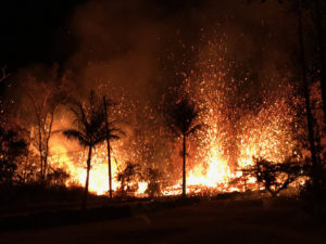
Episode 34 lava fountaining ended October 1 at 7:03 a.m. HST after approximately 6 hours of continuous activity. Incandescence was visible in both the north and south vents last night, indicating that magma within the conduits is close to the surface. Continuous seismic harmonic tremor started sometime during the day on October 14. Kīlauea’s summit region continued to inflate over the past 24 hours, with rates indicating that the next fountaining episode is likely to start between October 17 and 22.
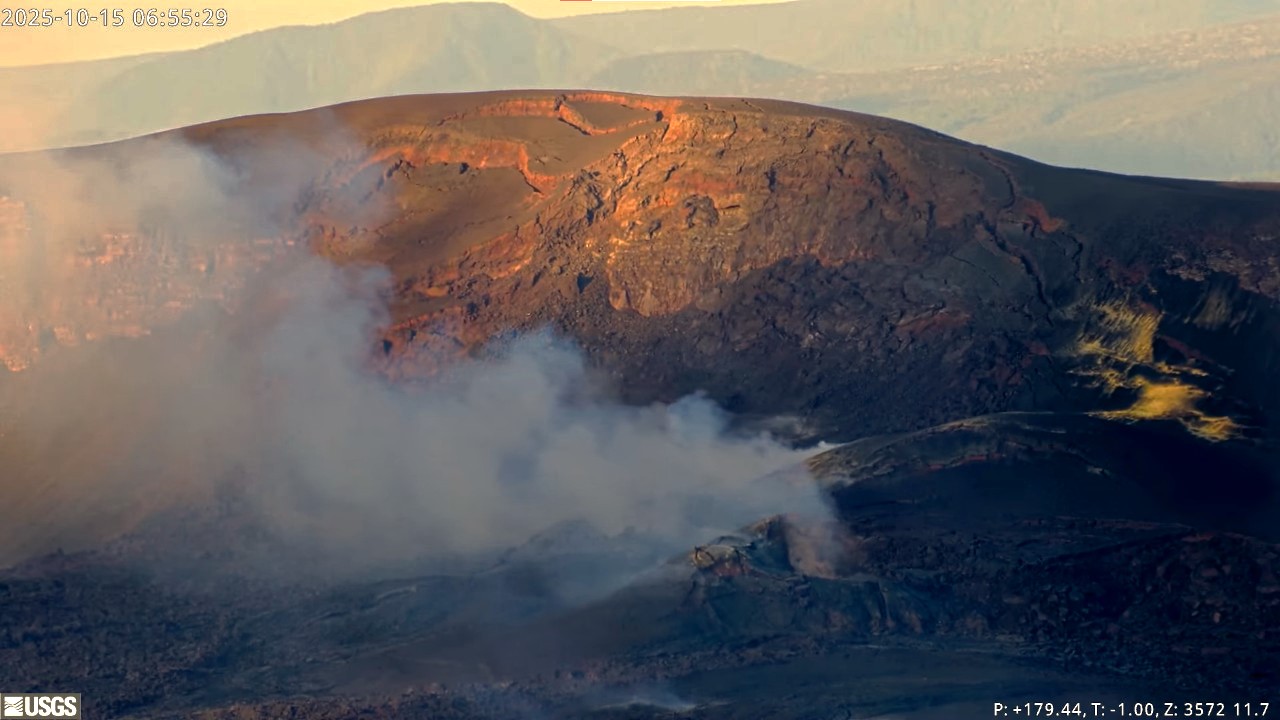
Summit Observations:
Halemaʻumaʻu continues to be quiet this morning with passive outgassing plumes rising from the north and south vents. Incandescence was visible in the north vent and south vents last night, with south vent incandesces being mostly continuous starting around 10 pm on October 14. Continuous seismic harmonic tremor started sometime during the day on October 14. The UWD tiltmeter shows continued inflationary tilt and as of this morning, the tiltmeter has recovered a total of approximately 20.6 microradians since episode 34 ended. Inflation rates since Sunday, October 12, have been lower than normal at less than 1 microradian a day.
Elevated degassing continues from the vents largely in bursts related to gas piston events. Overall, average sulfur dioxide (SO2) emission rates during pauses are typically 1,200 to 1,500 t/d, though emission rates can vary on short time scales.
Source et photo : HVO
Philippines , Kanlaon :
KANLAON VOLCANO ADVISORY , 16 October 2025 , 10:15 AM
Notice of increased seismic activity at Kanlaon Volcano.
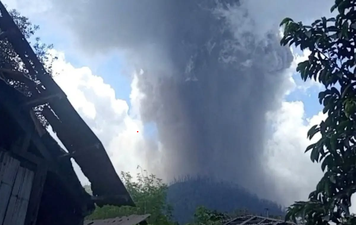
A total of eighty-one (81) volcano-tectonic or VT earthquakes have been recorded by the Kanlaon Volcano Network between 12:00 AM of 16 October 2025 and 10:00 AM today, 16 October 2025. These events ranged in strength between ML 0.1 and ML 2.9 and were generated at 0 to 6 kilometers depths beneath the northwestern flanks of the volcanic edifice. VTs are generated by rock fracturing processes and the increase in VT activity strongly indicates progressive rock-fracturing beneath the volcano as rising magma or magmatic gas drives a path towards the surface. Volcanic sulfur dioxide (SO2) gas emissions from the summit crater of Kanlaon based on campaign mDOAS measurements yesterday, 15 October 2025, averaged 1,879 tonnes/day, near the medium-term average of 1,830 tonnes/day since 1 January 2025. These parameters indicate that the blockage of volcanic gas emission (or closed-system degassing) may result in pressurization and swelling of the edifice potentially leading to moderately explosive eruption.
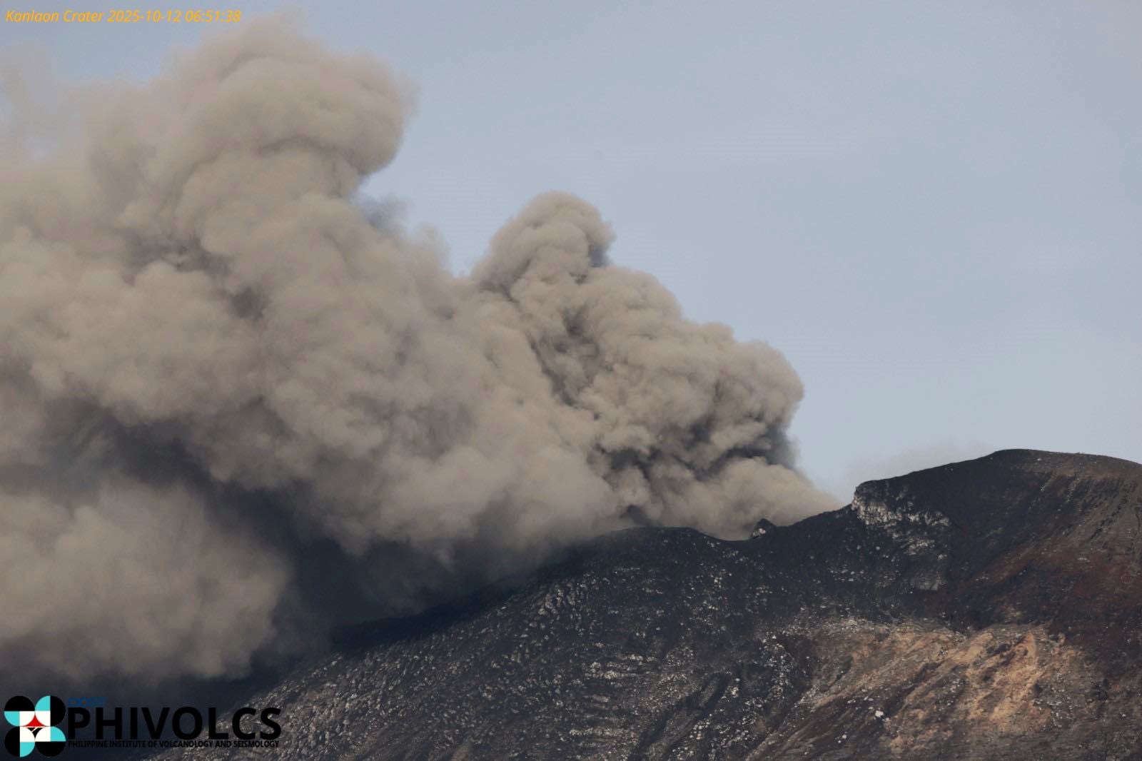
The public is reminded that Alert Level 2 prevails over Kanlaon, which means that the volcano is in a state of increased unrest. The increase in VT events could lead to increased chances of steam-driven or phreatic eruptions or short-lived weak to moderately explosive eruptions occurring at the summit that could generate life-threatening volcanic hazards such as pyroclastic density currents or PDCs, ballistic projectiles, ashfall, rockfall and other. It is strongly recommended that communities within the 4-km Permanent Danger Zone or PDZ strictly remain evacuated and those within the 6-km radius from the summit crater be vigilant and ready in case unrest worsens. In addition, increased vigilance against potential syn-eruption lahars and sediment-laden streamflows in channels draining the edifice is strongly advised should intense rains occur during eruptive unrest. Civil aviation authorities must also advise pilots to avoid flying close to the volcano’s summit as ash from any sudden eruption can be hazardous to aircraft.
DOST-PHIVOLCS maintains close monitoring of Kanlaon Volcano and any new development will be immediately communicated to all concerned stakeholders.
Source et photo : DOST-PHIVOLCS
Guatemala , Santiaguito :
Atmospheric Conditions: Cloudy
Wind: East
Precipitation: 30.0 mm
Activity
The Santiaguito Volcano Observatory reports favorable conditions for observing the dome despite cloud cover. Faint white fumaroles from degassing are observed at an altitude of 400 meters above the dome of Dome Caliente, as well as weak and sometimes moderate explosions, at a frequency of 1 to 3 per hour, raising columns of gas and ash to a height of 900 meters, which move westward with the wind.
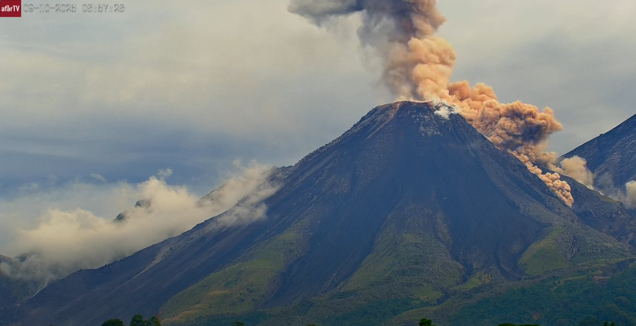
Incandescence can be observed on the dome, as well as the detachment of incandescent rock blocks towards the west and southwest flanks. Due to the wind direction, small ash particles could fall on Monte Maria, Loma Linda and the surrounding area. Due to the abundant accumulation of rocky material on the dome of Caliente Dome and on the promontory above the lava flow on its southwest flank, the latter could collapse and generate pyroclastic density currents over long distances towards the southwest, south, southeast and northeast. Therefore, the recommendations of Special Bulletin BESAN-063-2025 must be followed.
Source : Insivumeh.
Photo : Afar tv Capture d’écran 12/09 / 2025 .