September 29 , 2025.
Indonesia , Dukono :
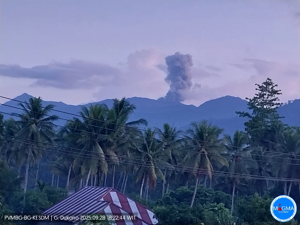
Mount Dukono erupted on Sunday, September 28, 2025, at 6:28 p.m. (local time). An ash column was observed about 700 m above the summit (about 1,787 m asl). The observed ash column was white to gray in color, with strong intensity directed toward the northwest. At the time of writing, the eruption was still ongoing.
Seismic Observations
9 eruption earthquakes with amplitudes of 5 to 7 mm and durations of 33.78 to 69.63 seconds.
1 continuous tremor with amplitudes of 2 to 6 mm, mainly 2 mm.
Recommendations
(1) Residents living around Mount Dukono and visitors/tourists are advised to avoid all activities, climbing, and approaching the Malupang Warirang crater within a 3 km radius.
(2) Given that volcanic ash eruptions occur periodically and their distribution depends on wind direction and speed, making the ash coverage area unstable, residents living around Mount Dukono are advised to always have masks/nose and mouth coverings available when needed to prevent the respiratory hazards of volcanic ash.
Source et photo : Magma Indonésie .
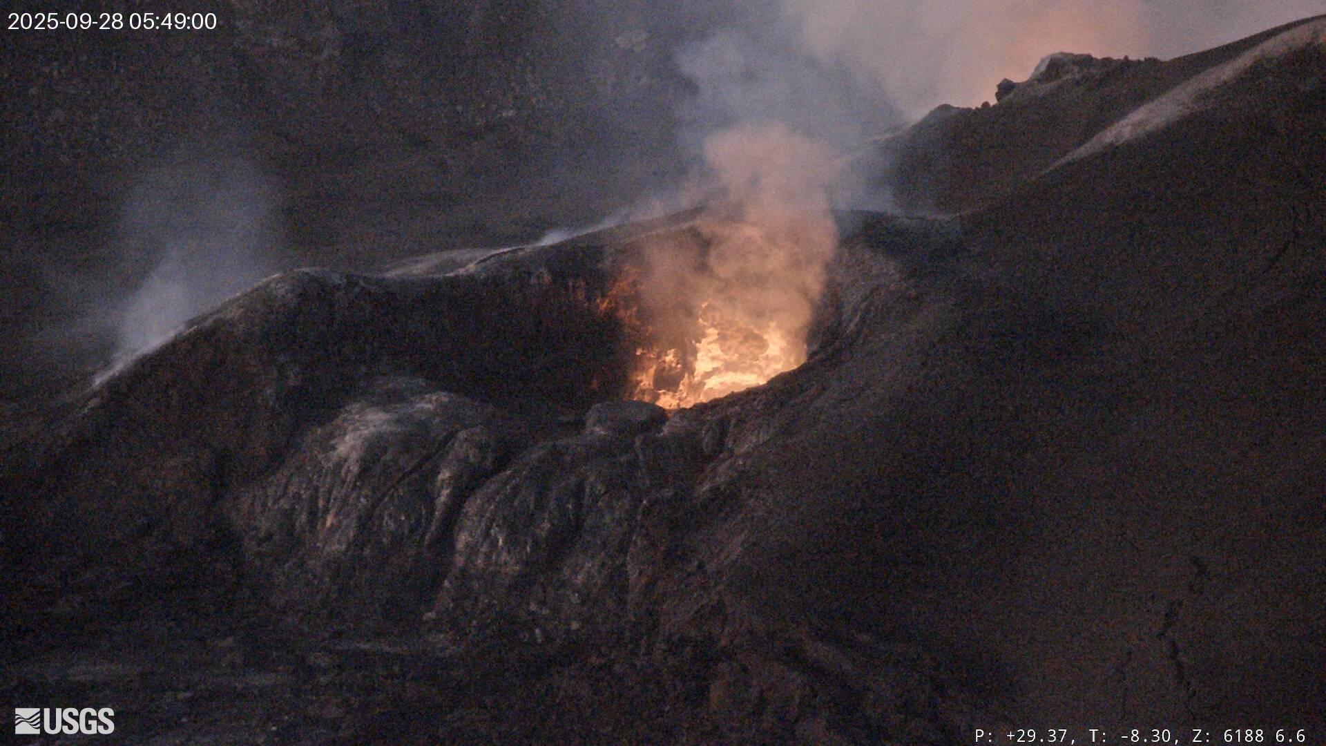
Hawaii , Kilauea :
HAWAIIAN VOLCANO OBSERVATORY DAILY UPDATE, U.S. Geological Survey
Sunday, September 28, 2025, 8:30 AM HST (Sunday, September 28, 2025, 18:30 UTC)
19°25’16 » N 155°17’13 » W,
Summit Elevation 4091 ft (1247 m)
Current Volcano Alert Level: WATCH
Current Aviation Color Code: ORANGE
Activity Summary:
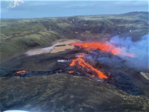
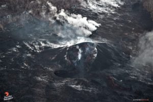
Episode 33 lava fountaining ended on September 19. Glow from both north and south vents was observed overnight, with rare weak spatter from north vent. The summit is reinflating, and models indicate that episode 34 is likely to start between today and October 1. No significant activity has been noted along Kīlauea’s East Rift Zone or Southwest Rift Zone.
Summit Observations:
Episode 33 lava fountaining ended at 12:08 p.m. HST on Friday, September 19. The UWD tiltmeter shows that the summit has been reinflating since the end of the fountaining episode, with 15 microradians of inflationary tilt. Overnight, HVO webcams showed persistent glow from north vent with rare weak spatter and occasional flames, and intermittent strong glow from south vent. This morning, the caldera is quiet with a passive outgassing plume rising from the vents.
Elevated degassing continues from the vent. Average sulfur dioxide (SO2) emission rates during pauses are typically 1,200 to 1,500 t/d, though emission rates can vary on short time scales.
Source et photo : HVO.
Chile , Laguna del Maule :
Seismology
Seismological activity during this period was characterized by:
32,808 VT-type earthquakes, associated with rock fracturing (volcano-tectonics). The most energetic earthquake, with a local magnitude (LM) of 4.1, occurred 5.0 km to the south-southwest and at a depth of 10.6 km from the center of the lagoon.
Six LP-type earthquakes, associated with fluid dynamics within the volcanic system (Long Period). The most energetic earthquake exhibited a reduced displacement (RD) of 5 cm².
One TR-type earthquake, associated with sustained fluid dynamics within the volcanic system (TRemor), exhibited a reduced displacement (RD) of 7 cm².
An HB-type earthquake, associated with both rock fracturing and fluid dynamics within the volcanic system (Hybrid). This earthquake, with a reduced displacement (RD) value of 9 cm² and a local magnitude (LM) of 1.1, occurred 8.7 km west-southwest and at a depth of 0.9 km from the center of the lagoon.
Fluid Geochemistry
No atmospheric sulfur dioxide (SO₂) emission anomalies have been reported near the volcanic complex, according to data published by the Tropospheric Monitoring Instrument (TROPOMI) and the Sulfur Dioxide Group of the Ozone Monitoring Instrument (OMI).
Satellite Thermal Anomalies
During this period, no thermal alerts were recorded in the area associated with the volcanic complex, according to analytical processing of Sentinel 2-L2A satellite images, combined with false-color bands.
Geodesy
Geodetic activity for the period was characterized by:
– GNSS vertical deformation rates, with maximum magnitude variations of 5.3 cm/month at the station closest to the center of the lagoon, indicating an increase in internal activity reflected at the surface, compared to the increase in activity measured from mid-May to the end of July of this year.
– Horizontal variation rates at GNSS monitoring stations, with variations of around 3.5 cm/month, a value considered high.
– An increase in the variation rate of GNSS monitoring lines (distance between GNSS stations), reaching a maximum of 4.5 cm/month for the period considered, a value consistent with the increase in activity measured using the previous parameters.
InSAR (Infrastructured Satellite Imagery) of Sentinel 1A (Single Look Complex-SLC) images reveals few signs of deformation due to poor coherence caused by the high presence of snow in the region.
Consequently, activity associated with deformation of the volcanic system remains above the historical average, demonstrating a continued increase in the volcanic complex’s internal activity.
Satellite Geomorphological Analysis
No morphological variations associated with volcanic activity were identified in Planet Scope and Sentinel 2 L2A satellite images.
After a period of intense seismic activity between September 1 and 9 (high occurrence and presence of energetic events of magnitudes 4.1 and 3.9), this activity gradually decreased, while remaining above its reference threshold. Interestingly, a sustained seismic swarm was recorded for at least 8 days, with events primarily located in the Troncoso-Nieblas (southwest), east, northwest, and center of the lagoon, near the zone of maximum deformation. The emergence of seismicity associated with fluid dynamics is notable, with the identification of a seismic tremor and two hybrids located in the Nieblas sector, these hybrids being the first recorded in this area.
These processes occurred in parallel with a steady increase in deformation rates measured by GNSS stations, particularly the PUEL-MAU2 line, which reached peak levels in historical monitoring records. The integration of these historical events, along with the temporal and spatial progression of activity observed in instrumental records, demonstrates a recent diversification of the complex’s internal dynamics.
The scenario suggests a continued evolution of volcanic activity, consistent with a technical alert status:
YELLOW TECHNICAL ALERT: Changes in the behavior of volcanic activity
Source : Sernageomin
Photo : Álvaro Vivanco , Photo prise au Sud-Ouest de la lagune de Maule.
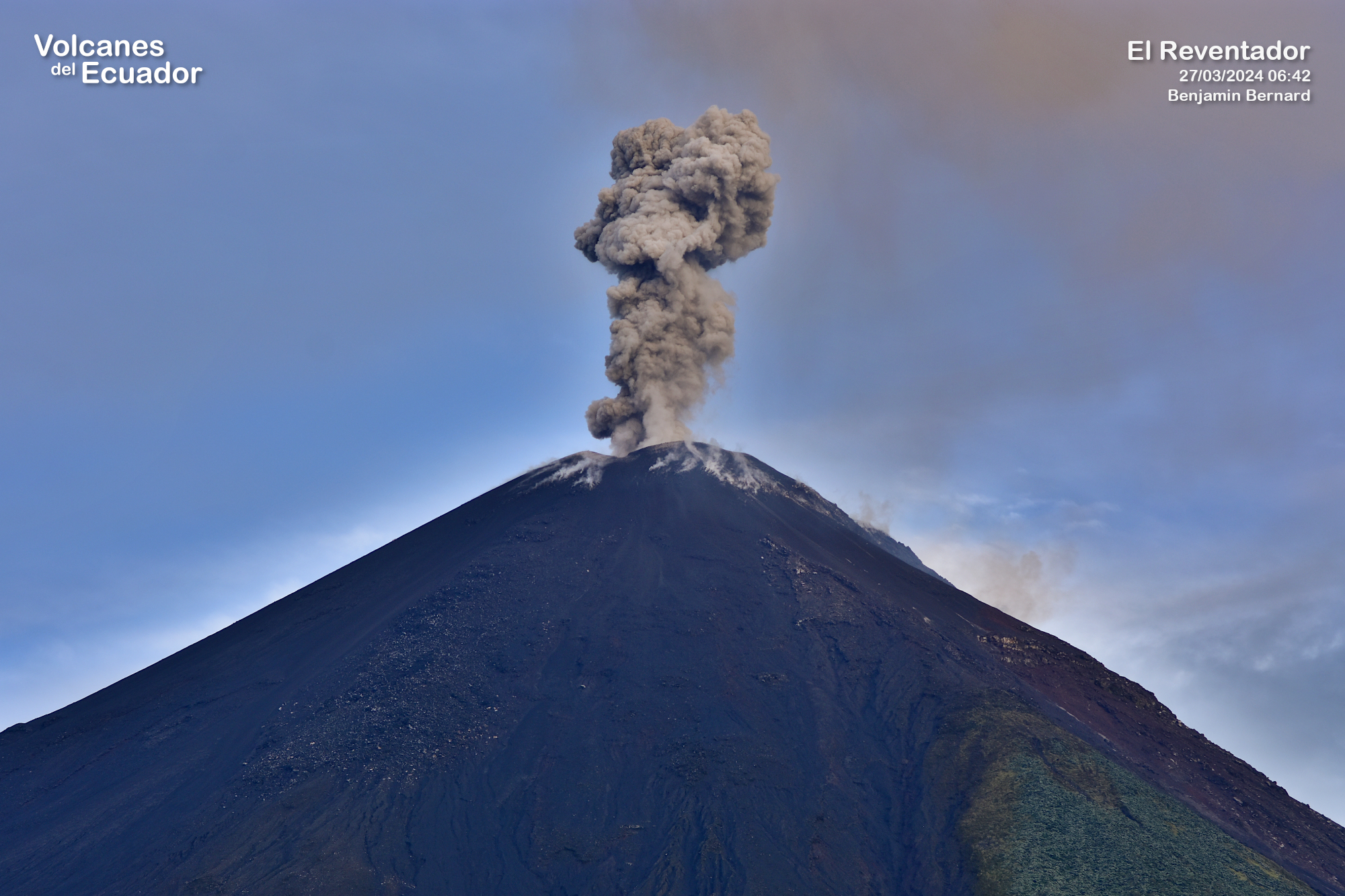
Ecuador , El Reventador :
DAILY STATUS REPORT OF REVENTADOR VOLCANO, Sunday, September 28, 2025.
Information Geophysical Institute – EPN.
Surface Activity Level: High, Surface Trend: No Change
Internal Activity Level: Moderate, Internal Trend: No Change
From September 27, 2025, 11:00 a.m. to September 28, 2025, 11:00 a.m.:
Seismicity:
Below is the count of seismic events recorded at the reference station.
Explosion (EXP) 87
Long Period (LP) 13
Emission Tremor (TREMI) 5
Harmonic Tremor (TRARM) 11
Precipitation/Lahars:
Precipitation was recorded in the volcanic area without generating mudflows or debris flows. **In the event of heavy rainfall, this could remobilize accumulated material, generating mudflows and debris flows that would cascade down the volcano’s flanks and flow into adjacent rivers.**
Emission/Ash Plume:
Thanks to the surveillance camera system, several gas and ash emissions were observed at heights between 500 and 1,100 meters above the crater level, in a northwesterly direction. As part of this activity, the Washington VAAC agency published two reports of ash emissions at heights of 700 meters above the crater level, in a west-northwest direction.
Other monitoring parameters:
Over the past 24 hours, the MIROVA-MODIS satellite system recorded two thermal anomalies, while the MIROVA-VIIRS 750 system recorded three, and the MIROVA-VIIRS 375 system recorded three.
Observation:
From last night until early morning, the monitoring system recorded several episodes of incandescent material descending up to 1,100 meters below the crater level. At the time of writing, the volcano is cloudy.
Alert Level – SGR: Orange
Source : IGEPN
Photo : Benjamin Bernard.
Costa Rica , Rincon de la Vieja :
Latitude: 10.83°N;
Longitude: 85.34°W;
Altitude: 1,916 m.
Current Activity Level: Warning.
This week, two eruptions and one exhalation were recorded. The eruption on September 21 at 7:14 p.m. was the most intense recorded since May 2023. It ejected ballistic projectiles and sediment from the crater toward the northern and northwest rims, but did not generate hot lahars. Residents of the communities of Buenos Aires and Gavilán reported a few days later that the Azul and Pénjamo rivers had whitish sediments following rainfall, resembling a secondary lahar.
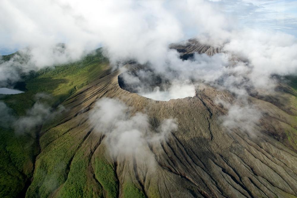
After the September 21 eruption, the background tremor increased slightly and remains continuous, with frequencies between 3 and 6 Hz. Long-period « tornillos »-type phenomena continue to occur. Geodetic observations show a contraction of the base and a displacement of the summit towards the crater. This week, DOAS stations detected an SO₂ flux of 65 ± 41 t/d. The MultiGAS station measured low gas concentrations (< 1 ppm SO₂). The last detection of SO₂ in the atmosphere by satellite measurement was on September 7. Direct observations suggest very little convective activity before the September 21 eruption.
Source et photo : Ovsicori