
September 25 , 2025.
Japan , Meakandake :
The Japan Meteorological Agency (JMA) reported eruptive activity at Me-Akan (also known as Meakan-dake, which means Meakan Peak) of the Akan volcanic complex during 16-23 September. Seismicity near Ponmachineshiri Crater that increased on 11 September continued to fluctuate at elevated levels. The seismic network recorded 27-50 daily volcanic earthquakes. Tilt in the direction of the crater continued at a low rate. Minor ashfall around the crater was visible on 16 September. During 17-23 September the volume of white steam-and-gas plumes rising from 96-1 Crater within Ponmachineshiri continued to be high; the plumes rose 200-800 m above the crater rim and drifting E and SE. The Alert Level remained at 2 (the second lowest level on a 5-level scale) and the public was warned to exercise caution within 500 m of Ponmachineshiri Crater.
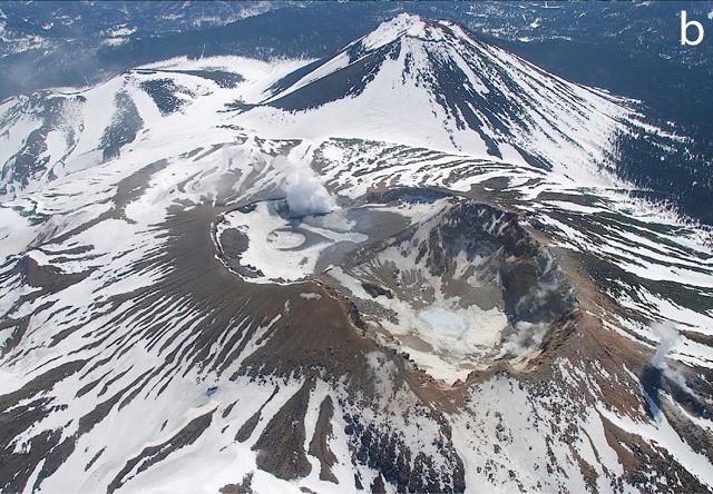
Akan is a 13 x 24 km caldera located immediately SW of Kussharo caldera. The elongated, irregular outline of the caldera rim reflects its incremental formation during major explosive eruptions from the early to mid-Pleistocene. Growth of four post-caldera stratovolcanoes, three at the SW end of the caldera and the other at the NE side, has restricted the size of the caldera lake. Conical Oakandake was frequently active during the Holocene. The 1-km-wide Nakamachineshiri crater of Meakandake was formed during a major pumice-and-scoria eruption about 13,500 years ago. Within the Akan volcanic complex, only the Meakandake group, east of Lake Akan, has been historically active, producing mild phreatic eruptions since the beginning of the 19th century. Meakandake is composed of nine overlapping cones. The main cone of Meakandake proper has a triple crater at its summit. Historical eruptions at Meakandake have consisted of minor phreatic explosions, but four major magmatic eruptions including pyroclastic flows have occurred during the Holocene.
Sources: Japan Meteorological Agency (JMA), GVP
Photo : Keiji Wada et JMA. – via GVP/ Bernard Duyck / FB.
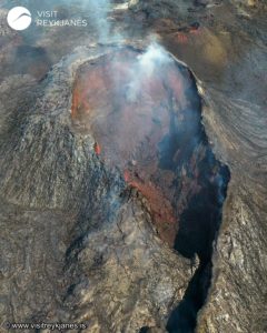
Iceland , Reykjanes Peninsula :
Magma accumulation under Svartsengi continues
The volume is approaching the amount that flowed out during the last event
Updated 23 September
Around 10 million cubic meters of magma have accumulated under Svartsengi since the last eruption.
The volume that flowed from Svartsengi during the last eruption was estimated at about 11–13 million cubic meters.The lower threshold of this volume is expected to be reached over the weekend.
The hazard assessment remains unchanged but will be reassessed on Thursday.
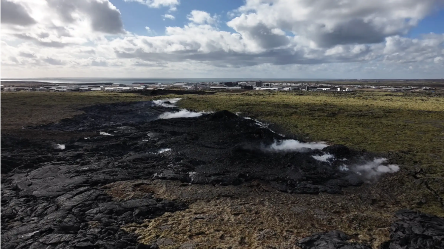
Land uplift and magma accumulation continue under Svartsengi and have been at a steady rate in recent weeks. Since the last eruption, which began on 16 July, about 10 million cubic meters of magma have reaccumulated in the magma storage area beneath Svartsengi.
Based on previous events on the Sundhnúkur crater row, the likelihood of a new magma outflow and eruption increases once an amount of magma equal to the last event has accumulated beneath Svartsengi. The volume that flowed from the magma storage area during that eruption is estimated at about 11–13 million cubic meters. If the accumulation rate remains unchanged, the lower threshold of this volume is expected to be reached over the weekend.
Therefore, the hazard assessment will remain unchanged until this lower threshold is reached and will next be updated on Thursday, 25 September.
Experience shows, however, that the thresholds for when an event begins vary between eruptions. The uncertainty in the timing of the next event is therefore considerable, and the current period of magma accumulation could be prolonged.
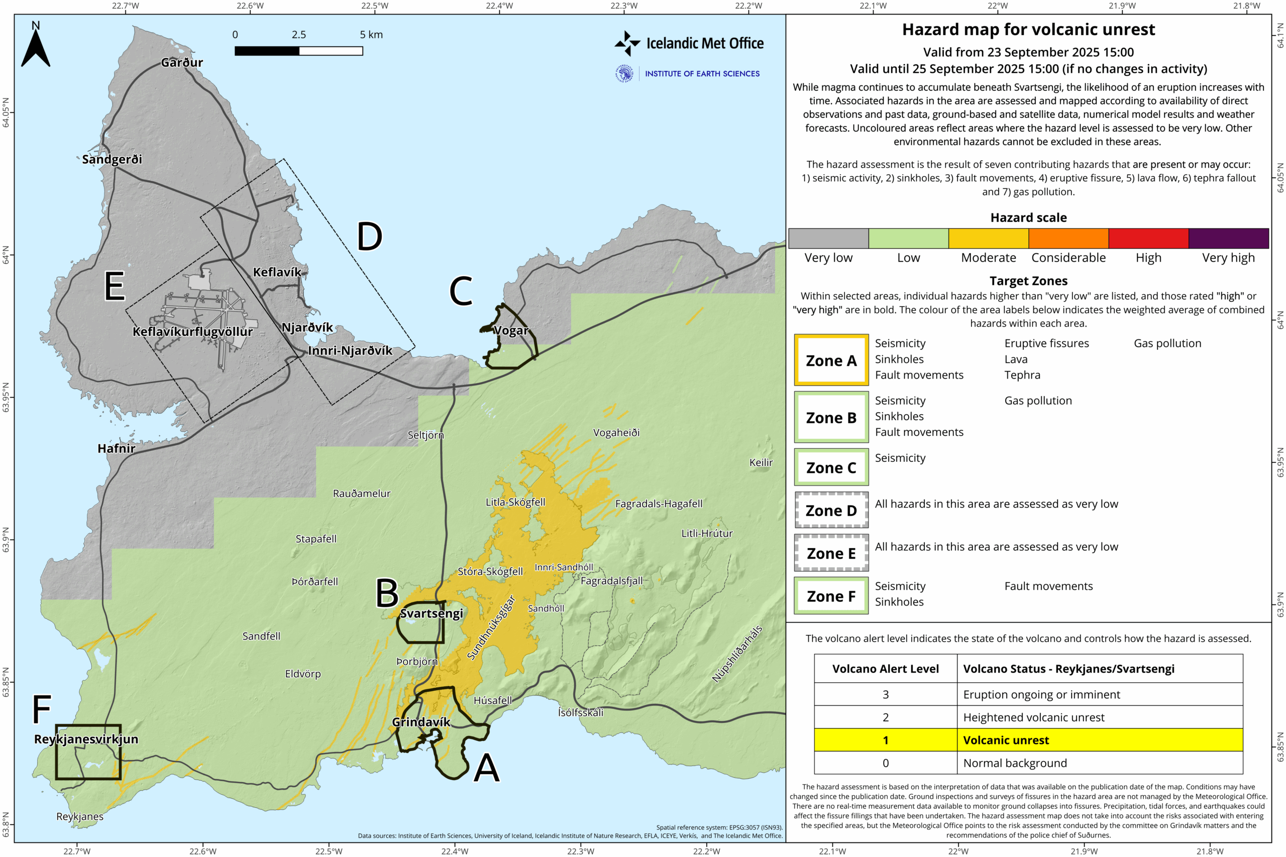
Ongoing seismic activity and subsidence west of Kleifarvatn
Seismic activity around the Sundhnúkur crater row remains very low, with only occasional small earthquakes below magnitude 1.0.
Seismic activity near Kleifarvatn and to the west of it continues, with several tens of earthquakes measured there on most days. The majority of these earthquakes are small, below magnitude 2.0. Subsidence measured west of Kleifarvatn continues at a steady rate.
Source : IMO.
Photos : IMO ,
Philippines , Mayon :
LAHAR ADVISORY FOR MAYON VOLCANO UNDER TROPICAL CYCLONE “OPONG”
24 September 2025 , 09:00 PM
Based on the Weather Advisory #21 issued at 05:00 PM today by the Philippine Atmospheric Geophysical and Astronomical Services Administration (PAGASA), the passage of Tropical Cyclone “OPONG” is expected to bring heavy to intense rains over the Bicol Region tomorrow afternoon (25 September 2025) to Friday afternoon (26 September 2025). These rains could generate volcanic sediment flows or lahars, muddy streamflows or muddy run-off in rivers and drainage areas on Mayon Volcano. DOST-PHIVOLCS thus strongly recommends increased vigilance and readiness of communities in pre-determined zones of lahar and related hazards.
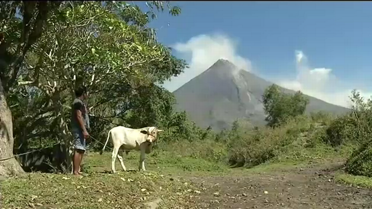
Heavy to intense rainfall can generate post-eruption lahars on major channels draining Mayon Volcano by incorporating loose material from remnant pyroclastic density current (PDC) deposits of the 2018 and 2023 Mayon eruptions. The bulk of erodible PDC deposits occupies the watershed areas of the Miisi, Mabinit, Buyuan and Basud Channels. In addition, older and erodible eruption deposits that occupy the watershed areas on the eastern and western slopes of the edifice and can be remobilized as non-eruption lahars by erosion of banks and channel beds. Mayon lahars can threaten communities downstream of the above channels with inundation, burial and wash away. Potential lahars and sediment-laden streamflows may occur along the Miisi, Binaan, Anoling, Quirangay, Maninila, Masarawag, Muladbucad, Nasisi, Mabinit, Matanag, Basud and Bulawan Channels in Albay Province.
DOST-PHIVOLCS strongly advises the communities and local government units of the above identified areas of risk to continually monitor the rainfall conditions and take pre-emptive response measures for their safety.
Source : DOST-PHIVOLCS
Photo : Auteur Inconnu .
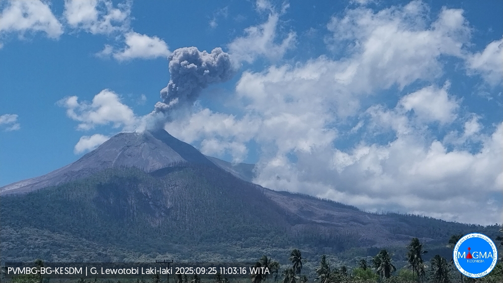
Indonesia , Lewotobi Laki-laki :
An eruption occurred at Lewotobi Laki-laki on Thursday, September 25, 2025, at 11:01 a.m. (local time). An ash column was observed about 1,200 m above the summit (about 2,784 m above sea level). The observed ash column was white to gray in color, with moderate to thick intensity, oriented southwest and west. At the time of writing, the eruption was still ongoing.
VOLCANO OBSERVATORY NOTICE FOR AVIATION – VONA
Issued : September 25 , 2025
Volcano : Lewotobi Laki-laki (264180)
Current Aviation Colour Code : ORANGE
Previous Aviation Colour Code : orange
Source : Lewotobi Laki-laki Volcano Observatory
Notice Number : 2025LWK446
Volcano Location : S 08 deg 32 min 20 sec E 122 deg 46 min 06 sec
Area : East Nusa Tenggara, Indonesia
Summit Elevation : 5069 FT (1584 M)
Volcanic Activity Summary :
Eruption with volcanic ash cloud at 03h01 UTC (11h01 local).
Volcanic Cloud Height :
Best estimate of ash-cloud top is around 8909 FT (2784 M) above sea level or 3840 FT (1200 M) above summit. May be higher than what can be observed clearly. Source of height data: ground observer.
Other Volcanic Cloud Information :
Ash cloud moving from southwest to west. Volcanic ash is observed to be white to gray. The intensity of volcanic ash is observed from medium to thick.
Remarks :
Eruption recorded on seismogram with maximum amplitude 29.6 mm and maximum duration 67 second.
The Pusat Vulkanologi dan Mitigasi Bencana Geologi (PVMBG) reported that on 19 September the seismic network at Lewotobi Laki-laki recorded an increase in the number of low-frequency earthquakes, followed by an eruption at 14h32 that produced ash plumes that rose 500-1,000 m above the summit. The Alert Level was raised to 4 (the highest level on a scale of 1-4) at 21h00 and the exclusion zone was increased to 6 km from the center of Laki-laki and 7 km in a semicircle clockwise from the SW to the NE. At 21h58 eruptive activity became continuous and remained continuous at least through 22h29, with ash plumes rising 800-1,500 m above the summit and drifting SW. At 22h46 an ash plume rose around 6 km above the summit and drifted W and SW and a webcam at that same time showed incandescent material on the upper flanks. Incandescent material being ejected straight up above the summit and falling onto the upper flanks was visible in a 22h54 webcam image. Ash plumes rose 3 km above the summit and drifted W and SW at 23h07, at 23h27, and at 23h41. Ash-and-gas emissions were continuous for most of 20 September. Multiple eruptive events produced ash plumes that rose as high as 3 km above the summit and drifted NW, W, and SW. Summit incandescence was visible in a few of the webcam images. According to a news report three flights using the Komodo International Airport, around 300 km W, were canceled on 20 September and two were rescheduled for the next day. Multiple eruptive events were recorded on 21 September. Ash plumes again rose as high as 3 km above the summit and drifted N, NW, W, and SW. Ash plumes during 22-23 September rose 600-2,000 m above the summit and drifted NW, W, and SW. Minor incandescence at the summit was visible in a webcam image at 19h15 on 22 September.
Sources : PVMBG , GVP.
Photo : PVMBG
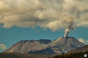
Colombia , Chiles / Cerro Negro :
San Juan de Pasto, September 23, 2025, 3:00 p.m.
Following monitoring of the activity of the Chiles-Cerro Negro Volcanic Complex (CVCCN), the Colombian Geological Survey (SGC), an entity affiliated with the Ministry of Mines and Energy, reports that:
From September 16 to 22, 2025, the main variations in the monitored parameters compared to the previous week were as follows:
• Seismic occurrence increased slightly; however, the energy released decreased by an order of magnitude. Seismicity associated with rock fracturing continues to predominate, followed by seismicity related to fluid dynamics.
• Localized seismicity was concentrated in two main groups. The first group was located within a 1.5 km radius of the summit of Chiles Volcano (4,700 m above sea level), with a northwest/southeast orientation. The earthquakes occurred at depths between 2.0 and 5.0 km. The maximum magnitude earthquake occurred between 2.1 and 0.3 km east-southeast of the summit, at a depth of 3.5 km. A second group was recorded between the two volcanoes, at depths between 2.0 and 4.5 km.
• Analysis of information obtained from satellite sensors and ground stations continues to indicate variations related to deformation processes in the volcanic area.
Based on the assessment and correlation of monitored parameters, the SGC recommends closely monitoring their developments through weekly bulletins and other information published through our official channels, as well as instructions from local and departmental authorities and the National Disaster Risk Management Unit (UNGRD).
Volcanic activity remains on yellow alert: active volcano with changes in the baseline behavior of monitored parameters and other manifestations.
Source et photo : SGC
Je lisais avec attention ce rapport sur les activités volcaniques mondiales, et jai été frappé par la diversité des phénomènes décrits – de lactivité seismique à la formation de lahars. La vigilance recommandée par les autorités comme le DOST-PHIVOLCS est vraiment justifiée, surtout face à la puissance de volcans comme Mayon et Lewotobi Laki-laki. Ces mises en garde nous rappellent à quel point la nature peut être imprévisible et redoutable. Il est encourageant de voir des mesures préventives prises, mais cela souligne aussi notre dépendance vis-à-vis des institutions qui nous protègent. Jespère que les populations concernées prendront ces conseils au sérieux et que les secours seront efficaces en cas durgence. La préparation, après tout, est notre meilleure arme face à ces forces uncontrollables.labubu live wallpaper