September 7 , 2025.
Philippines , Mayon :
MAYON VOLCANO ADVISORY , 06 September 2025 , 5:30 PM
Notice of increased seismic activity in Mayon Volcano.
Since 12:00 AM today, 6 September 2025, a total of 26 volcanic earthquakes have been recorded by the Mayon Volcano Network. These events registered at strengths of ML0.4-ML2.7 and most originated at depths of 5-10 kilometers beneath the northeast flank of the Mayon edifice. Mayon has been exhibiting non-uniform inflation or swelling in its northeastern sector since October 2024 and its south to southwestern sectors since March 2025 based on continuous GPS, electronic tilt and EDM ground deformation data. Sulfur dioxide SO2 emissions have remained near background levels, averaging 430 tonnes/day this year with the latest measurements on 3 September 2025 averaging 609 tonnes/day. Increased seismicity today as well as longer-term swelling of the edifice could indicate that deep magma intrusion may be taking place beneath the volcano, which could increase the chances of steam-driven or phreatic eruptions occurring at the crater.
DOST-PHIVOLCS would like to remind the public that Mayon Volcano is at Alert Level 1, which means that it is at an abnormal condition. Although this means that no magmatic eruption is imminent as of present, the public is strongly advised to refrain from entering the 6-kilometer radius Permanent Danger Zone (PDZ) due to life-threatening hazards such as rockfall, landslides/avalanches, ballistic projectiles and short pyroclastic density currents (PDCs) or “uson” that could be generated by a sudden phreatic eruption from the summit. Active stream/river channels and those identified as perennially lahar-prone areas on all sectors of the volcano should also be avoided especially during extreme weather conditions when there is heavy and prolonged rainfall. Civil aviation authorities must advise pilots to avoid flying close to the volcano’s summit as airborne ash and ballistic fragments from sudden explosions and PDCs may pose hazards to aircraft.
DOST-PHIVOLCS maintains close monitoring of Mayon Volcano and any new development will be communicated to all concerned stakeholders.
Source : DOST-PHIVOLCS
Photo : Auteur Inconnu
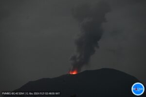
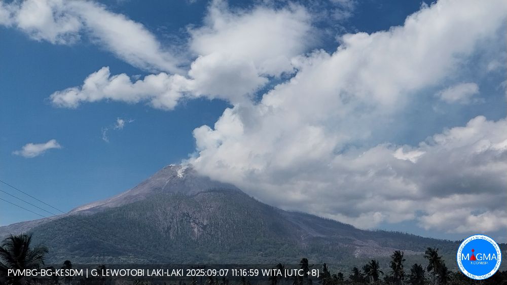
Indonesia , Lewotobi Laki-laki :
An eruption occurred at Lewotobi Laki-laki on Saturday, September 6, 2025, at 6:06 PM (local time). The observed ash column rose about 1,000 m above the summit (about 2,584 m above sea level). The ash column was gray, moderate to thick in intensity, and oriented southwest, west, and northwest. At the time of writing, the eruption was still ongoing.
VOLCANO OBSERVATORY NOTICE FOR AVIATION – VONA
Issued : September 6 , 2025
Volcano : Lewotobi Laki-laki (264180)
Current Aviation Colour Code : ORANGE
Previous Aviation Colour Code : orange
Source : Lewotobi Laki-laki Volcano Observatory
Notice Number : 2025LWK405
Volcano Location : S 08 deg 32 min 20 sec E 122 deg 46 min 06 sec
Area : East Nusa Tenggara, Indonesia
Summit Elevation : 5069 FT (1584 M)
Volcanic Activity Summary :
Eruption with volcanic ash cloud at 10h05 UTC (18h05 local).
Volcanic Cloud Height :
Best estimate of ash-cloud top is around 8269 FT (2584 M) above sea level or 3200 FT (1000 M) above summit. May be higher than what can be observed clearly. Source of height data: ground observer.
Other Volcanic Cloud Information :
Ash cloud moving from southwest, west to northwest. Volcanic ash is observed to be gray. The intensity of volcanic ash is observed from medium to thick.
Remarks :
Eruption recorded on seismogram with maximum amplitude 5.9 mm and maximum duration 153 second. Tremor recorded on seismogram with maximum amplitude 5.9 mm.
Source et photo : PVMBG
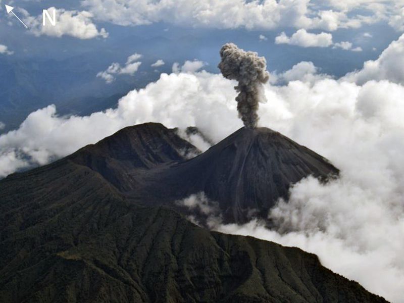
Colombia , Galeras :
San Juan de Pasto, September 2, 2025, 6:55 p.m.
Regarding the monitoring of the activity of the Galeras Volcano, the Colombian Geological Survey (SGC), an entity affiliated with the Ministry of Mines and Energy, reports that:
During the week of August 26 to September 1, 2025, the main variations in the monitored parameters compared to the previous week were:
● A decrease in the number of earthquakes was recorded, accompanied by an increase in the seismic energy released. Seismicity related to rock fracturing processes
within the volcanic edifice continued to predominate. ● In general, earthquakes associated with rock fracturing have been located at two sources: one near the main crater, at a depth of less than 2 km, and the other about 6 km northeast of the active cone, at depths between 6 and 11 km. Of note is the earthquake that occurred on August 30 at 6:18 p.m., felt by residents of the municipalities of Psto, El Tambo, Chachaguí, La Florida, Consacá, La Unión, Buesaco, Guaitarilla and Túqierres, in the department of Nariño. This earthquake, located 6 km northeast of the active cone, at a depth of 8 km, had a magnitude of 3.6. Subsequently, an earthquake that occurred at 5:13 a.m. on August 31, with a magnitude of 2.5, located 12 km from the municipality of Buesaco and at a depth of 9 km, was also felt in the municipality of Buesaco, in the department of Nariño.
● Gas emissions were recorded in the fumarole fields of El Paisita, to the north, Las Chavas, to the west of the active cone, and the main crater floor area, with low white columns whose dispersion varies depending on the wind direction.
● Other volcanic monitoring parameters remained stable.
Based on the above, the SGC recommends closely monitoring their development through weekly bulletins and other information published through our official channels, as well as instructions from local and departmental authorities and the National Disaster Risk Management Unit (UNGRD).
Volcanic activity remains on alert. Yellow: Active volcano with changes in the baseline behavior of monitored parameters and other manifestations.
Source et photo : SGC
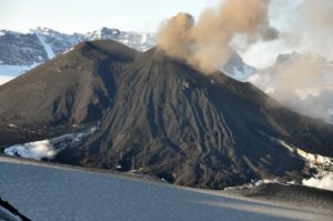
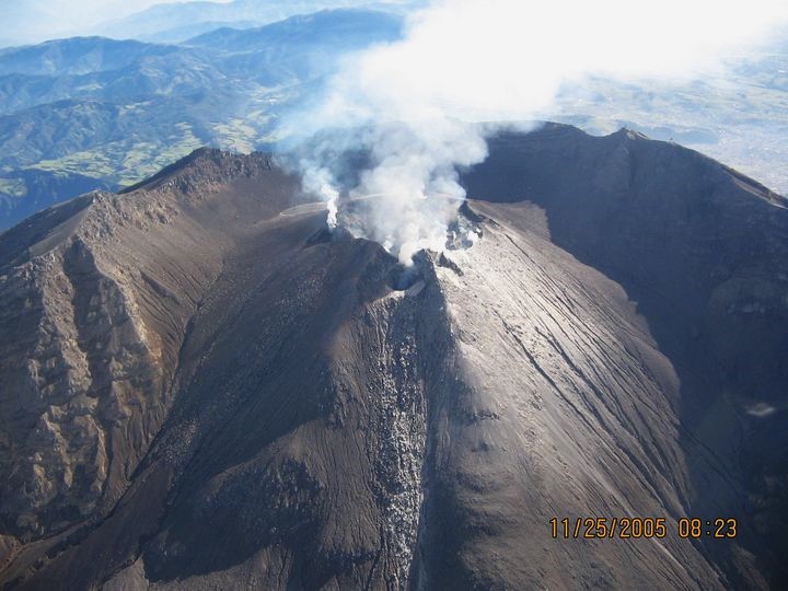
Ecuador , El Reventador :
DAILY STATUS REPORT OF REVENTADOR VOLCANO, Saturday, September 6, 2025.
Information Geophysical Institute – EPN.
Surface Activity Level: High, Surface Trend: No change
Internal Activity Level: Moderate, Internal Trend: No change
From September 5, 2025, 11:00 a.m. to September 6, 2025, 11:00 a.m.:
Seismicity:
Below is the count of seismic events recorded at the reference station.
Explosion (EXP) 93
Long Period (LP) 9
Emission Tremor (TREMI) 12
Harmonic Tremor (TRARM) 5
Rainfall/Lahars:
No rainfall has been recorded in the volcanic area. **Heavy rainfall could remobilize accumulated material, generating mud and debris flows that would cascade down the volcano’s flanks and flow into adjacent rivers.
Emission/Ash Column:
Since yesterday afternoon, several gas and ash emissions have been observed by surveillance cameras. The ash columns reached heights between 300 and 1,100 meters above the crater, in a westerly direction. In this regard, the Washington VAAC has issued three reports of ash clouds projecting westward, at heights between 700 and 1,000 meters above the crater.
Other monitoring parameters:
The MIROVA-MODIS satellite system recorded one thermal anomaly, and the FIRMS satellite system another, over the past 24 hours.
Observation:
During last night and early this morning, surveillance cameras recorded several episodes of incandescent material falling on the volcano’s flanks, up to 1,000 meters below the crater level. At the time of writing, the volcano remained cloudy.
Alert Level – SGR: Orange
Source : IGEPN
Photo : f-Naranjo , GVP.
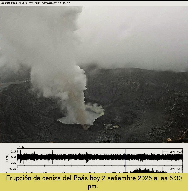
Costa Rica , Poas :
OVSICORI-UNA Weekly Volcano Monitoring Bulletin, September 5, 2025
Latitude: 10.20°N;
Longitude: 84.23°W;
Altitude: 2,687 m
Current Activity Level: Alert
On the afternoon of September 2, two ash emissions were recorded. They occurred without a seismic signal, but with a slight increase in the intensity of the acoustic tremor. The amplitude of the background seismic tremor remains stable compared to recent months. Between August 31 and September 2, a sequence of short, low-amplitude tremors, with a repetition period of approximately one minute, was recorded. The acoustic tremor emanating from Vent A continues to be of variable intensity. This week, a distal volcano-tectonic event was recorded, and the number of long-period events has increased.
In recent weeks, no significant deformation of the volcano’s crust has been detected. MultiGAS stations measured an average SO2/CO2 ratio of 1.4 ± 0.5 this week, identical to last week.
The H2S/SO2 ratio has remained very low (< 0.1) in recent weeks.
Based on observed reports, the gases are interpreted to be originating from a surface magmatic source.
The ExpoGAS station located at the visitor lookout measured a maximum of 3.4 ppm SO2 this week. DOAS stations measured an SO2 flux of 400 ± 22 t/d. Furthermore, satellite measurements of atmospheric SO2 show a decrease, with few plume detections this week (an SO2 mass between 150 and 250 tons). On August 29, a maximum temperature of 923 degrees Celsius was measured remotely at night from the visitor lookout at Mouth A using a handheld thermograph and a special FLIR germanium infrared lens for maximum magnification measurements. Consequently, a significant heat flux persists at the crater floor. The level of the new hyperacid lake at Mouth C continues to rise and is approaching Mouth A, which is experiencing a significant flow of gas and heat. This contact could generate significant phreatic eruptions that could affect visited areas of the national park (e.g., ballistic projections projected toward the lookout).
Level 2 (Caution) does not exclude ballistic events in visited areas. Each phase of activity carries a potential risk.
Source et photo : Ovsicori