September 5 , 2025.
Hawaii , Kilauea :
HAWAIIAN VOLCANO OBSERVATORY DAILY UPDATE , U.S. Geological Survey
Thursday, September 4, 2025, 9:17 AM HST (Thursday, September 4, 2025, 19:17 UTC)
19°25’16 » N 155°17’13 » W,
Summit Elevation 4091 ft (1247 m)
Current Volcano Alert Level: WATCH
Current Aviation Color Code: ORANGE
Activity Summary:
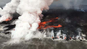
Episode 32 of the ongoing Halemaʻumaʻu eruption ended abruptly at 8:01 p.m. HST on September 2 after 13.4 hours of continuous fountaining. Minor incandescence of the cones and lava flow field was observed overnight as these regions cooled. The high rate of inflation indicates another episode is likely no earlier than late next week.
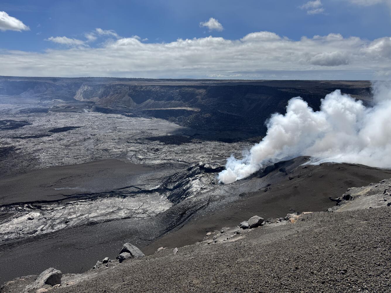
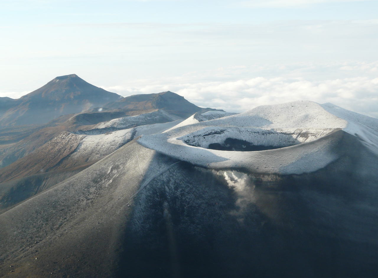
USGS Hawaiian Volcano Observatory geologists visited the caldera rim at Kīlauea summit to assess the aftermath of episode 32 lava fountaining. The vent was quiet, with no audible sounds, and a thick outgassing plume rose from the vents. The broad lava channel that was fed from episode 32 lava fountaining can be seen here extending to the left side of the image.
Summit Observations:
Lava flows from episode 32 covered 40-50% of the floor of Halemaʻumaʻu within the southern part of Kaluapele (Kīlauea caldera) and continued to show minor incandescence overnight.
The Uēkahuna tiltmeter (UWD) recorded about 25 microradians of deflationary tilt during this episode. The end of the eruption was coincident with a rapid change from deflation to inflation at the summit and a decrease in seismic tremor intensity. The Uēkahuna tiltmeter (UWD) has recorded approximately 4.3 microradians of inflationary tilt since the episode ended. Patterns of tremor indicate that gas pistoning is probably occurring deeper within the vent and is marked by low frequency bursts every 2-5 minutes.
Elevated degassing continues from the vent. Average sulfur dioxide (SO2) emission rates during inter-episode pauses are typically 1,200 to 1,500 t/d, though emission rates vary on short time scales in association with gas-pistoning.
Source : HVO
Photo : USGS / M. Patrick.
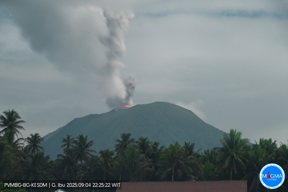
Indonesia , Ibu :
Mount Ibu erupted on Thursday, September 4, 2025, at 10:25 p.m. (local time). An ash column was observed about 800 m above the summit (about 2,125 m above sea level). The ash column was white to gray in color, with intense intensity, oriented northwest. This eruption was recorded by seismograph with a maximum amplitude of 28 mm and a duration of 46.29 seconds.
Seismic Observations
43 eruption earthquakes with amplitudes ranging from 4 to 28 mm and durations ranging from 37 to 63 seconds.
3 emission earthquakes with amplitudes ranging from 6 to 9 mm and durations ranging from 37 to 46 seconds.
12 harmonic tremors with amplitudes ranging from 2 to 5 mm and durations ranging from 37 to 179 seconds.
51 low-frequency earthquakes with amplitudes ranging from 2 to 10 mm and durations ranging from 20 to 27 seconds.
78 shallow volcanic earthquakes with amplitudes ranging from 2 to 10 mm and durations ranging from 7 to 22 seconds.
2 deep volcanic earthquakes with amplitudes ranging from 7 mm and durations ranging from 23 to 29 seconds.
Nine distant tectonic earthquakes with amplitudes ranging from 2 to 28 mm, and lasting from 26 to 113 seconds.
Recommendations
1. Residents of the vicinity of Mount Ibu and visitors/tourists are advised to avoid all activities within a 2 km radius and within a 3.5 km radius of the crater opening, in the northern part of the active crater of Mount Ibu.
2. In the event of ashfall, those engaging in outdoor activities are advised to wear face masks and protective eyewear.
Source et photo : Magma Indonésie .
Italy , Campi Flegrei :
Weekly Bulletin, from August 25, 2025 to August 31, 2025. (Publication date: September 2, 2025)
SUMMARY OF ACTIVITIES
Based on monitoring data, the following points are highlighted:
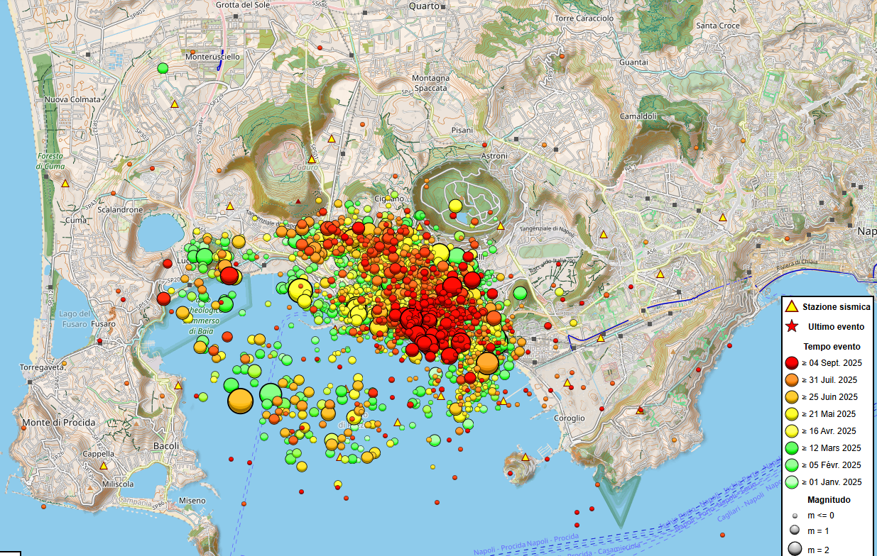
1) SEISMOLOGY: During the week of August 25 to 31, 2025, 109 earthquakes with a magnitude Md ≥ 0.0 (Mdmax = 3.3 ± 0.3) were recorded in the Phlegraean Fields region.
2) DEFORMATIONS: Since the beginning of April 2025, ground uplift has continued to be recorded, with a monthly average of approximately 15 ± 3 mm/month. 3) GEOCHEMISTRY: During the reporting week, no significant changes in monitored geochemical parameters were reported, compared to the already known trends of increased flow rates and warming of the hydrothermal system.
SEISMOLOGY
From August 25 to 31, 2025, 109 earthquakes with a magnitude Md ≥ 0.0 (Mdmax = 3.3 ± 0.3) were recorded in the Phlegraean Fields region.
73 earthquakes were recorded during three seismic swarms:
1. On August 26, 2025, at 05:27 UTC, 8 earthquakes with a magnitude 0.0 ≤ Md ≤ 1.6 (± 0.3) occurred in the Pozzuoli-Agnano region;
2. On August 29, 2025, at 09:45 UTC, four earthquakes with a magnitude of 0.0 ≤ Md ≤ 2.3 (± 0.3) occurred in the Pozzuoli-Accademia region;
3. From 14:09 UTC on August 31, 2025, until midnight of the same day, 61 earthquakes with a magnitude of ≤ 0.0 ≤ Md ≤ 3.3 (± 0.3) occurred in the Solfatara-Accademia-Agnano region. This swarm continued until 18:26 on September 1, 2025, with another 55 earthquakes with a magnitude of ≤ 0.0 ≤ Md ≤ 4.0 (± 0.3) occurring in the same area.
GROUND DEFORMATIONS
Data collected after the earthquake swarm of February 15-19, 2025, showed an increase in the rate of ground uplift, with a monthly average value of approximately 30 ± 5 mm/month until the end of March. Since the beginning of April, ground uplift has continued to be recorded, with a monthly average value of approximately 15 ± 3 mm/month.
The total uplift recorded at the RITE GNSS station is approximately 32 cm since January 2024.
.
GEOCHEMISTRY
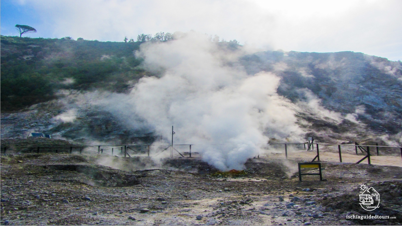
During the reporting week, continuous data monitored by the geochemical network did not show any significant variations in the acquired parameters, although they confirmed the warming and pressurization trends of the hydrothermal system, as well as the increase in the flow rate of emitted fluids. In the Pisciarelli area (northeastern external slope of the Solfatara), which has experienced the greatest variations in the degassing process in recent years, the soil CO2 flux values continuously recorded by the FLXOV8 station highlight the persistence of the multi-year trends already identified. Last week, the soil CO2 fluxes measured by the FLXOV8 station did not show any significant variations compared to previous periods.
During the last week, the average temperature reached approximately 94°C, a temperature close to the condensation point of the fumarolic fluid. At the Pisciarelli site, variations in basin fluid level and emission temperatures, derived from continuous data, show an increasing control of meteorological conditions on the local degassing process, suggesting a local decrease in the latter. Conversely, in the Solfatara crater area, during the reference week, temperatures measured by the FLXOV5 station of the main fumarole (BG) confirm this increasing trend, with a measured mean value of about 165 °C, similarly to the increase in diffuse flows and equilibrium temperatures of the hydrothermal system.
Source : INGV vulcani .
Photos : INGV, Ischia guide tours . com
Iceland , Reykjanes Peninsula:
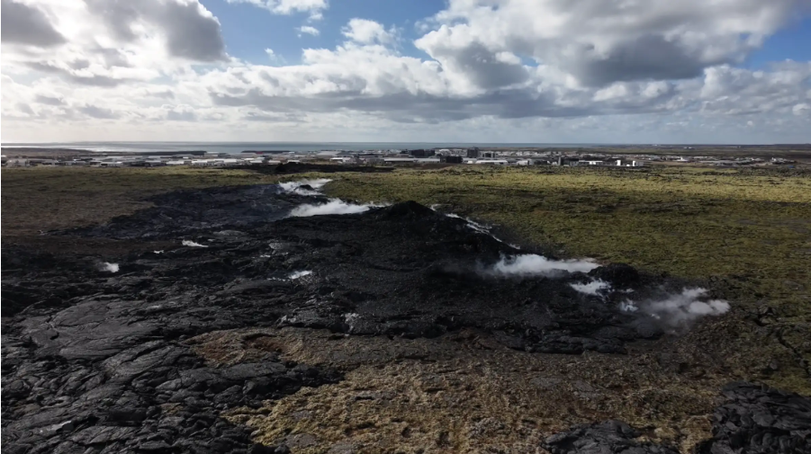
Considerable uncertainty about the timing of the next possible eruption on the Sundhnúkur crater row , 4.9.2025
Uplift and magma accumulation under Svartsengi continues
Around 6 to 7 million cubic meters of magma have accumulated beneath Svartsengi since the last eruption.
It is assumed that when about 12 million cubic meters have accumulated, the likelihood of a new event increases.
If the current rate of magma accumulation remains steady, the likelihood of a new event will increase in the latter half of September.
A new hazard assessment is valid until 16 September.
There is still some hazard on and around the new lava field.
Uplift and magma accumulation beneath Svartsengi continues and the rate of accumulation has been steady in recent weeks. Model calculations estimate that around 6 to 7 million cubic meters of magma have accumulated beneath Svartsengi since the eruption that began on 16 July. The volume of magma released from the storage area beneath Svartsengi during that eruption is estimated at around 12 million cubic meters.
Based on experience from eruptions on the Sundhnúkur crater row, it is expected that the probability of a new dike intrusion and eruption increases once approximately the same volume of magma has accumulated beneath Svartsengi as was released in the previous event. Looking at the most recent eruption, this suggests that once 12 million cubic meters have built up again, the probability of a new event will rise. At the current rate of accumulation, this volume will be reached in the latter half of September.
An eruption should be expected, but its timing remains highly uncertain
It is important to note that the volume of magma released from Svartsengi in each eruption since March 2024 has varied considerably, ranging from 12 to 31 million cubic meters. It is therefore unwise to assume that the next event will behave exactly like the last one. The previous event may have been unusual in terms of how much magma had to accumulate beneath Svartsengi to trigger an eruption. Experience from recent events also shows that even small changes in the accumulation rate can shift the timing of the next possible eruption by several weeks. The uncertainty in timing is therefore considerable, and the current accumulation period could last longer than expected.
Monitoring and preparedness assume an eruption could begin at any time
IMO’s model calculations provide indications of when the likelihood of the next event may increase, but monitoring and preparedness plans are based on the assumption that an eruption could start at any time.
If an eruption does occur, the most likely source area is between Sundhnúkur and Stóra-Skógfell. Signs of an imminent eruption include microseismic activity and sharp deformation changes detected by fiber-optic and GPS instruments, as well as pressure changes in boreholes. The expected warning time before an eruption is short, as in previous events, ranging from 20 minutes up to just over 4 hours.
Source : IMO .
Photo : RÚV – Víðir Hólm Ólafsson Capture d’écran 2025-04-05
Colombia , Puracé – Chaîne volcanique Los Coconucos :
Popayán, September 2, 2025, 3:00 p.m.
Regarding the monitoring of the activity of the Puracé volcano and the Los Coconucos volcanic chain, the Colombian Geological Survey (SGC), an entity affiliated with the Ministry of Mines and Energy, reports that:
During the week of August 26 to September 1, 2025, a decrease in the number of seismic events related to rock fracturing processes was recorded. These events were located mainly between the Puracé and Piocollo volcanoes, at depths between 1 and 3 km, with calculated magnitudes below 1.0. The earthquakes related to fluid movements were characterized by low energy input and were mainly located beneath the western flank of the Puracé volcano crater, at a depth of less than 1 km.
Satellite and ground-based instruments have recorded moderate levels of sulfur dioxide (SO2) emissions. Furthermore, the slow deformation process detected after the eruption of Curiquinga Volcano on January 20, 2025, persists.
Visible and infrared webcam images continue to show degassing processes and thermal anomalies inside the Puracé Volcano crater and in the fumarole field on its outer rim.
In conclusion, the variations observed at the Puracé volcano and the Los Coconucos volcanic chain indicate that the system remains active and that monitoring parameters remain above their baseline.
In the yellow alert status, phenomena such as sporadic ash emissions (minor eruptions of limited magnitude and effects, whose dispersion depends on wind direction), the presence of incandescence, small explosions in the crater, low-energy thermal anomalies, noise, felt earthquakes, odors, precipitation of elemental sulfur near the crater and in hot springs and fumaroles, as well as degassing in areas other than the crater, may occur. Minor fissures and lahars, among others, may also form.
The alert status for volcanic activity remains yellow: active volcano with changes in the baseline behavior of monitored parameters and other manifestations.
Source et photo : SGC.