August 24 , 2025 .
Hawaii , Kilauea :
HVO/USGS Volcanic Activity Notice
Current Volcano Alert Level: WATCH
Current Aviation Color Code: ORANGE
Issued: Saturday, August 23, 2025, 3:23 AM HST
Source: Hawaiian Volcano Observatory
Notice Number: 2025/H373
Location: N 19 deg 25 min W 155 deg 17 min
Elevation: 4091 ft (1247 m)
Area: Hawaii
Volcanic Activity Summary:
Episode 31 of the ongoing Halemaʻumaʻu eruption ended abruptly at 2:52 a.m. HST on August 23 after 12.6 hours of continuous fountaining.
The north vent stopped erupting at approximately 2:52 a.m. HST marking the end of episode 31. The south and intermediate vents stopped erupting earlier at approximately 12:40 a.m. and 2:46 a.m. HST. Lava fountains from the north vent reached up to 325 ft (100 m) and sustained this height during most of this episode. Fountains from the south and intermediate vents remained small, less than 33 feet (10 meters) for most of the time, but the intermediate vent fountains increased to 60-100 ft (20-30 m) by the evening of August 22. Approximately 10,900,000 cubic yards (8,400,000 cubic meters) of lava were erupted at an average of 240 cubic yards per second (185 cubic meters per second) during the fountaining phase. Lava flows from this episode covered more than 75% of the floor of Halemaʻumaʻu within the southern part of Kaluapele (Kīlauea caldera) and may continue to exhibit slow movement or incandescence as they cool and solidify over the coming days.
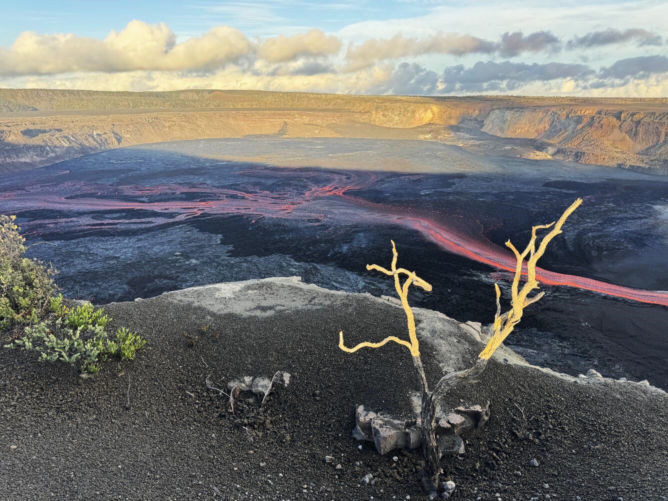
31 episodes of lava fountaining at the summit of Kīlauea since December 23, 2024, have covered the floor of Halemaʻumaʻu with a patchwork of lava flows of varying ages. With each episode, more of the crater floor is covered and in total, the lava flows have filled over 260 (80 meters) of the crater with new lava.
Voluminous fountaining was preceded by continuous spattering in the north vent that began at approximately 8:30 a.m. HST and continued to increase in intensity until 11:45 a.m. HST, when sustained lava overflows began. During this period, a cone was built inside the north vent sealing off part of the old vent.
Fountaining in the north vent began increasing significantly at 2:04 p.m. HST accompanied by deflationary tilt and increasing tremor. The north vent transitioned to an arcuate fountain approximately 100 feet (30 meters) high feeding multiple lava streams at 2:18 p.m. HST corresponding with the change to steep deflation and high tremor. Sometime around 4-5 p.m. HST, low spatter fountains began to feed a small flow from the south vent. At 7:23 p.m. HST, a new intermediate vent opened up in the area of glowing cracks between the north and south vents.
Volcanic gas emissions have greatly decreased since the end of the episode.
The Uēkahuna tiltmeter (UWD) recorded about 22 microradians of deflationary tilt during this episode. The end of the eruption was coincident with a rapid change from deflation to inflation at the summit and a decrease in seismic tremor intensity.
Source : HVO.
Photo : USGS / M. Patrick.
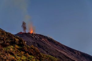
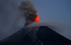
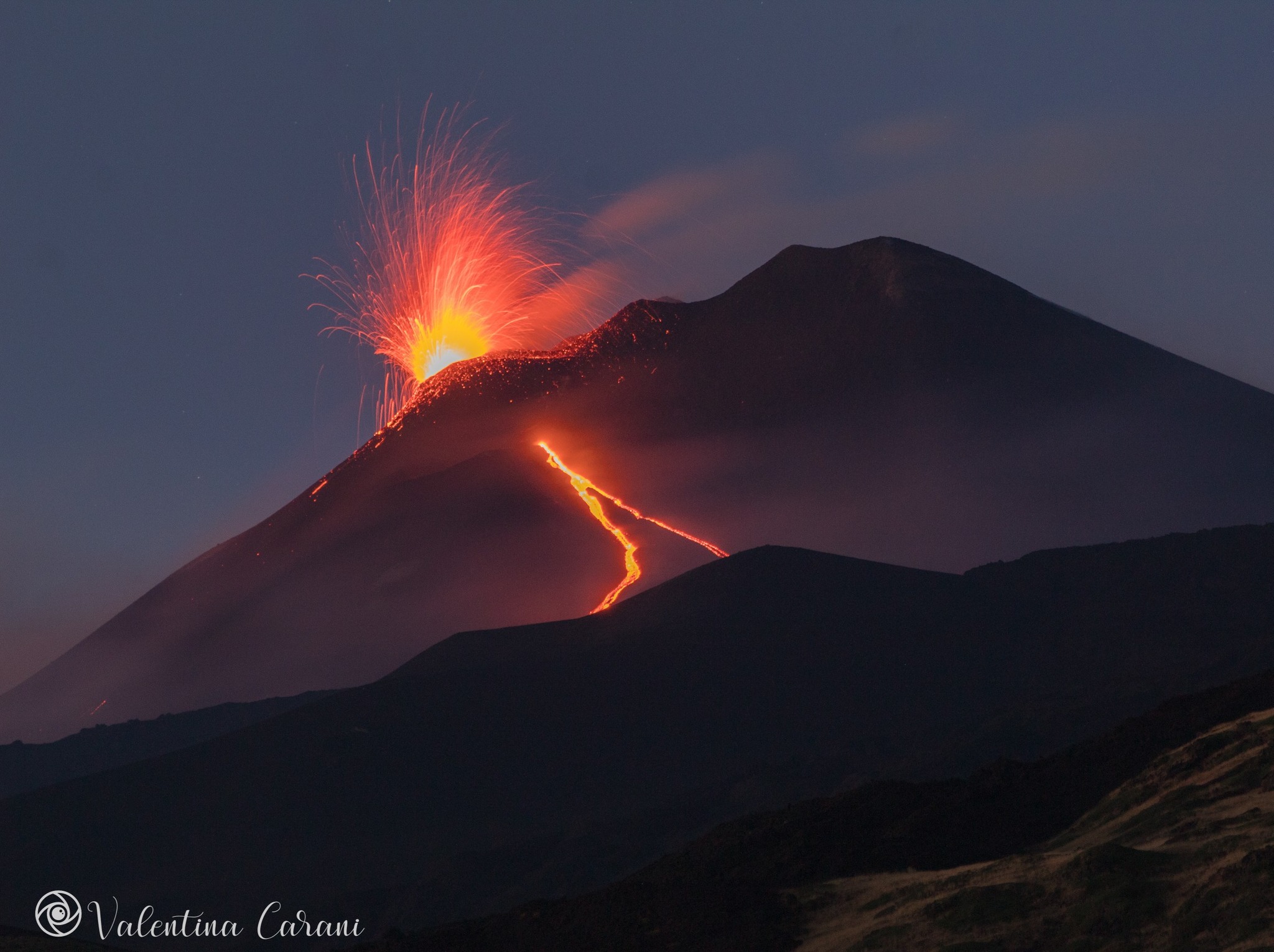
Italy / Sicily , Etna :
Etna Activity Statement, August 23, 2025, 9:12 PM (7:12 PM UTC).
The National Institute of Geophysics and Volcanology, Osservatorio Etneo, announces that, according to volcanological observations made by INGV personnel at the summit and analysis of images acquired by the video surveillance network, effusive activity is continuing at the vent located at an altitude of 2,980 m. This vent feeds a southwesterly lava field, whose most advanced front is located at an altitude of approximately 2,250 m. Effusive activity is also continuing at the vent located at an altitude of approximately 3,200 m, on the southern flank of the southeast crater, and at the vent located at an altitude of 3,100 m, whose fronts are located at an altitude of approximately 3,000 m. Strombolian activity also continues in the Southeast Crater, with eruptions of pyroclastic products falling beyond the crater rim.
Since the last update yesterday, August 22nd, the average amplitude of the seismic tremor has remained high. After a further increase recorded late last night, the signal has decreased slightly since 02:40 UTC today.
The amplitude is currently stable, despite slight oscillations, always in the high frequencies. The centroid of the tremor sources remains located in the southeast crater area, at approximately 3,000 meters above sea level. Regarding infrasound activity, monitoring is partially affected by the presence of strong winds in the summit area. However, based on the available locations and seismogram analysis, sustained infrasound activity, with low-amplitude events, located in the southeast crater, is evident. Ground deformation signals recorded by GNSS and inclinometer networks currently show no significant variation.
The DRUV dilatometer station continues to show a slow variation in decompression, accumulating a total of approximately -25 nanostrains since the beginning of the current effusive activity.
Updates will be provided shortly.
Source : INGV.
Photo : Valentina Carani .
Indonesia , Lewotobi Laki-laki :
MOUNT LEWOTOBI LAKI-LA’S ACTIVITY LEVEL CHANGE FROM LEVEL IV (AWAS) TO LEVEL III (SIAGA) ON AUGUST 23, 2025, 6:00 PM WITA
Mount Lewotobi Laki-laki is an active volcano in East Nusa Tenggara Province that periodically exhibits increased volcanic activity. Recently, Mount Lewotobi Laki-laki has exhibited increased activity, characterized by eruptions, volcanic tremors, and shallow earthquakes. According to visual and instrumental monitoring, the volcano’s activity level was previously at Level IV (Awas). However, recent advances in visual and seismic data analysis indicate a decrease in the intensity of activity.
The monitoring results for Mount Lewotobi Laki-laki are as follows:
The volcano is clearly visible, to the point of being covered by a thin layer of fog. An eruption occurred at an altitude of 800 to 1,000 meters above the summit, producing a column of gray ash.
Seismic data from August 22 and 23, 2025, at 12:00 WITA (Central Indonesia Time), included:
4 eruption earthquakes,
29 emission earthquakes,
32 nonharmonic tremors,
26 low-frequency earthquakes,
8 deep volcanic earthquakes,
12 distant tectonic earthquakes.
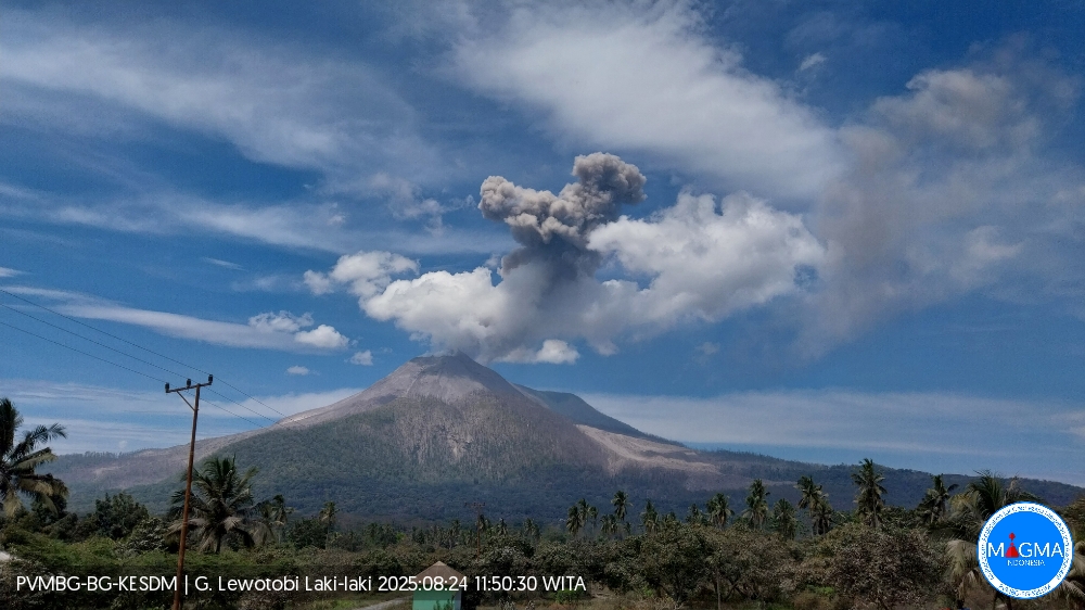
An eruption of Mount Lewotobi Laki-laki occurred on Sunday, August 24, 2025, at 11:47 WITA. The observed ash column was ± 1,500 m above the summit (± 3,084 m above sea level). The ash column was gray and of strong intensity, oriented southwest and west. This eruption was recorded by a seismograph with a maximum amplitude of 10.5 mm and a duration of 122 seconds.
Seismic data indicate a decreasing trend in volcanic activity toward short-term stability, dominated by shallow earthquakes and surface earthquakes. Four eruptions occurred following the rise of magma at shallow depths. The incandescence around the summit appears weak, indicating that the incandescent material is beginning to cool. Current seismic activity is dominated by shallow earthquakes. However, an increase in low-frequency earthquakes has been recorded over the past three days, indicating that the magmatic system remains unstable, allowing for a continued influx of gas and magma.
Tiltmeter monitoring over the past three days shows a fluctuating but relatively stable trend, indicating the absence of magma influx at shallow depths. Meanwhile, Global Navigation Satellite System (GNSS) data over the past five days indicate an inflationary trend, but a deflation of the vertical component has been observed over the past two days. This situation indicates that new magma is slowly moving from the depths to lower depths, with no significant influx observed to date. The process of magma migration from the depths to lower depths is still ongoing, raising the risk of a small-scale eruption.
Based on the results of a comprehensive analysis and evaluation of visual and instrumental monitoring, the activity level of Mount Lewotobi Laki-laki has been lowered from Level IV (AWAS) to Level III (SIAGA) effective August 23, 2025 at 18:00 WITA with the following recommendations: the public and tourists are advised not to carry out activities within a 6 km radius of the eruption center, to remain calm, and to follow the directives of the local government.
Source et photo : PVMBG.
Colombia , Galeras :
San Juan de Pasto, August 19, 2025, 3:30 p.m.
Regarding the monitoring of the activity of the Galeras Volcano, the Colombian Geological Survey (SGC), an entity affiliated with the Ministry of Mines and Energy, reports that:
During the week of August 12 to 18, 2025, the main variations in the monitored parameters compared to the previous week were:
● An increase in the occurrence and released seismic energy was observed. The predominance of seismic activity related to rock fracture processes within the volcanic edifice continued.
● Fracture earthquakes were mainly located near the volcanic crater, at depths less than 3 km from the summit of the Galeras Volcano (4,200 m above sea level). A few others were scattered around the volcanic edifice, reaching depths of up to 10 km. The most intense event, with a magnitude of 1.3, was recorded on August 18 at 7:47 a.m., 4.4 km northeast of the main crater.
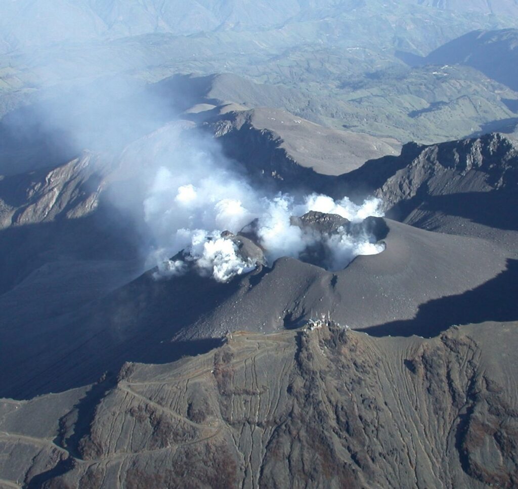
● Low gas emissions were observed, mainly from the fumarole fields of El Paisita, to the north, and Las Chavas, to the west of the active cone, with low white columns and variable dispersion depending on the wind direction.
● Other volcanic monitoring parameters showed stability.
In view of the above, the SGC recommends closely monitoring developments through weekly bulletins and other information published through our official channels, as well as instructions from local and departmental authorities and the National Disaster Risk Management Unit (UNGRD).
Volcanic activity remains on alert. Yellow: Active volcano with changes in the baseline behavior of monitored parameters and other manifestations.
Source et photo : SGC.
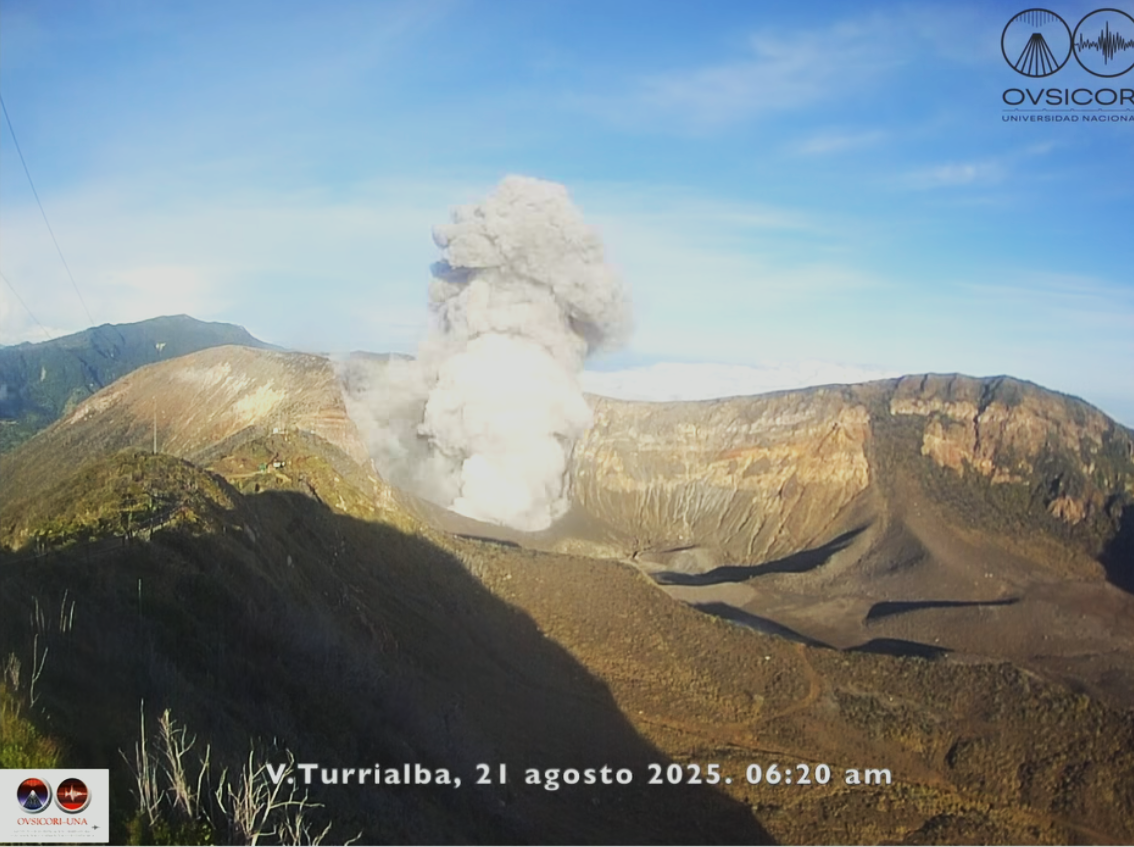
Costa Rica , Turrialba :
Latitude: 10.02°N;
Longitude: 83.76°W;
Altitude: 3,325 m
Current activity level: Warning.
Seismo-acoustic monitoring parameters are stable. No eruption has been recorded. Long-period, biphase, and coda events have been recorded. Material from the inner crater wall (rocks and fine solid particles) fell on August 21 at 6:20 PM, 7:04 PM, and 9:19 PM, generating an ash plume due to collapse. Geodetic monitoring detects stable crustal deformation with contraction and subsidence, mainly in the crater region.
The MultiGAS station recorded a weekly average H₂S/SO₂ of 0.3 ± 0.04, a value similar to previous weeks, while a CO₂/SO₂ ratio of 10.4 was measured; these values are slightly above normal, but within the range observed this year. The DOAS stations estimated an SO2 flux of 51 ± 46 t/d. SO2 was detected in the atmosphere by satellite measurements on August 16 and 19, with a maximum value below 10 tons.
The volcanic plume in the West Crater is showing increased vigor due to the abundant influx of rainwater into the volcanic edifice.
Source and photo : Ovsicori .